|
Indiana State Road 203
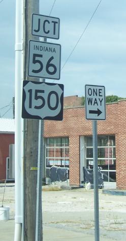
State Road 203 is a 14-mile north–south highway in the U.S. state of Indiana Indiana () is a U.S. state in the Midwestern United States. It is the 38th-largest by area and the 17th-most populous of the 50 States. Its capital and largest city is Indianapolis. Indiana was admitted to the United States as the 19th s ... that runs mostly in Scott County. Route description At the south end, State Road 203 begins just within Clark County at State Road 362 and passes north through the town of Lexington. It is concurrent with both State Road 3 and State Road 56 east of Scottsburg, and then continues north to State Road 256 near New Frankfort. History In September 2012, the section of SR 203 in Clark County was decommissioned. Major intersections References External links 203 Transportation in Clark County, Indiana Transportation in Scott County, Indiana {{Indiana-road-stub ... [...More Info...] [...Related Items...] OR: [Wikipedia] [Google] [Baidu] |
New Frankfort, Indiana
New Frankfort is an unincorporated community in Johnson Township, Scott County, in the U.S. state of Indiana Indiana () is a U.S. state in the Midwestern United States. It is the 38th-largest by area and the 17th-most populous of the 50 States. Its capital and largest city is Indianapolis. Indiana was admitted to the United States as the 19th s .... History New Frankfort was founded in 1838, and named after Frankfort, Kentucky, the native home of a large share of the early settlers. A post office was established at New Frankfort in 1838, and remained in operation until it was discontinued in 1901. References Unincorporated communities in Scott County, Indiana Unincorporated communities in Indiana {{ScottCountyIN-geo-stub ... [...More Info...] [...Related Items...] OR: [Wikipedia] [Google] [Baidu] |
Clark County, Indiana
Clark County is a county in the U.S. state of Indiana, located directly across the Ohio River from Louisville, Kentucky. At the 2020 census, the population was 121,093. The county seat is Jeffersonville. Clark County is part of the Louisville/Jefferson County, KY–IN Metropolitan Statistical Area. History Clark County lies on the north bank of the Ohio River. A significant gateway to the state of Indiana, Clark County's settlement began in 1783. The state of Virginia rewarded General George Rogers Clark and his regiment for their victorious capture of Forts Kaskaskia, Cahokia, and Vincennes from the British, by granting them of land. A small portion of this land, , became known as Clarksville, the first authorized American settlement in the Northwest Territory, founded the next year in 1784. Clark County Genealogical Records (accessed 21 January ... [...More Info...] [...Related Items...] OR: [Wikipedia] [Google] [Baidu] |
Scott County, Indiana
Scott County is a county located in the U.S. state of Indiana. As of 2010, the population was 24,181. The county seat is Scottsburg. History Scott County was formed in 1820 from portions of Clark, Jackson, Jefferson, Jennings, and Washington counties. It was named for Gen. Charles Scott, who was Governor of Kentucky from 1808 to 1812. Geography According to the 2010 census, the county has a total area of , of which (or 98.78%) is land and (or 1.22%) is water. Cities and towns * Austin * Scottsburg * Lexington Unincorporated towns * Blocher * Nabb * Vienna * Leota Townships * Finley * Jennings * Johnson * Lexington * Vienna Adjacent counties * Jennings County (north) * Jefferson County (east) * Clark County (south) * Washington County (west) * Jackson County (northwest) Major highways * Interstate 65 * U.S. Route 31 * State Road 3 * State Road 56 * State Road 160 * State Road 203 * State Road 256 * State Road 356 * State Road 362 Clima ... [...More Info...] [...Related Items...] OR: [Wikipedia] [Google] [Baidu] |
Indiana
Indiana () is a U.S. state in the Midwestern United States. It is the 38th-largest by area and the 17th-most populous of the 50 States. Its capital and largest city is Indianapolis. Indiana was admitted to the United States as the 19th state on December 11, 1816. It is bordered by Lake Michigan to the northwest, Michigan to the north, Ohio to the east, the Ohio River and Kentucky to the south and southeast, and the Wabash River and Illinois to the west. Various indigenous peoples inhabited what would become Indiana for thousands of years, some of whom the U.S. government expelled between 1800 and 1836. Indiana received its name because the state was largely possessed by native tribes even after it was granted statehood. Since then, settlement patterns in Indiana have reflected regional cultural segmentation present in the Eastern United States; the state's northernmost tier was settled primarily by people from New England and New York, Central Indiana by migrants fro ... [...More Info...] [...Related Items...] OR: [Wikipedia] [Google] [Baidu] |
Indiana State Road 362
State Road 362 in the U.S. state of Indiana is a short seven-mile (11 km) route in the southeastern portion of the state. Route description State Road 362 straddles the Clark County border with Scott and Jefferson Jefferson may refer to: Names * Jefferson (surname) * Jefferson (given name) People * Thomas Jefferson (1743–1826), third president of the United States * Jefferson (footballer, born 1970), full name Jefferson Tomaz de Souza, Brazilian foo ... counties. It begins at State Road 3 near Garry's Trucking Service and runs directly east along the county line, intersecting with State Road 203 and passing through the town of Nabb. It terminates where it reaches State Road 62 north of New Washington. Major intersections References External links Indiana Highway Ends - SR 362 362 Transportation in Clark County, Indiana Transportation in Jefferson County, Indiana Transportation in Scott County, Indiana {{Indiana-road-stub ... [...More Info...] [...Related Items...] OR: [Wikipedia] [Google] [Baidu] |
Lexington, Indiana
Lexington is an unincorporated community in Lexington Township, Scott County, in the U.S. state of Indiana, located about 10 miles west of the Ohio River and 28 miles north of Louisville, Kentucky. The town itself was founded before Indiana became the 19th state in 1816 and was located in Jefferson County at the time it was platted. It was the original county seat from 1820 to 1874, before local leaders decided on a more central location at nearby Scottsburg, which created animosity between the residents of the two towns for several decades afterwards. History Lexington was originally settled in 1804 and platted in 1810. It was one of eight towns that were considered for the first state capital of Indiana, with Corydon gaining the honor. It was originally in Jefferson County until 1820, when Scott County was created from parts of Jennings, Jefferson, Clark, Washington and Jackson counties. This area of the state was largely settled by people from the Upper South, traveling by ... [...More Info...] [...Related Items...] OR: [Wikipedia] [Google] [Baidu] |
Indiana State Road 56
State Road 56 in the U.S. state of Indiana is a route that travels the south central part of the state from west to east. Route description The western terminus of SR 56 is near Hazleton at U.S. Route 41. SR 56 heads northeast to Hazleton. After Hazleton SR 56 turns southeast then back northeast, until State Road 65 (SR 65). Where SR 56 heads east towards Petersburg, in Petersburg SR 56 is Concurrent with State Road 57 (SR 57), until the intersection with State Road 61 (SR 61). SR 56 leaves Petersburg concurrent with SR 61 heading south, until SR 56 turns east. South of Otwell SR 56 has an intersection with State Road 257. SR 56 enters Jasper on the west side and then has an intersection with U.S. Route 231, the two routes are concurrent until they leave Jasper on the north side of town. North of Jasper SR 56 turns east towards Paoli passing through French Lick. East of Paoli SR 56 heads towa ... [...More Info...] [...Related Items...] OR: [Wikipedia] [Google] [Baidu] |
Scottsburg, Indiana
Scottsburg is a city within Vienna Township and the county seat of Scott County, in the U.S. state of Indiana, about north of Louisville, Kentucky. The population of Scottsburg was 7,345 at the 2020 census. History Scottsburg was platted in 1871. The city was named for Horace Scott, a railroad official. A post office has been in operation at Scottsburg since 1873. The Scott County Home, Scottsburg Courthouse Square Historic District, and Scottsburg Depot are listed on the National Register of Historic Places. Geography Scottsburg is located at (38.685361, -85.769597). According to the 2010 census, Scottsburg has a total area of , of which (or 99.63%) is land and (or 0.37%) is water. Climate The climate in this area is characterized by hot, humid summers and cold Midwest winters. According to the Köppen Climate Classification system, Scottsburg has a humid subtropical climate, abbreviated "Cfa" on climate maps. Demographics In 2003 Scott County was removed from the ... [...More Info...] [...Related Items...] OR: [Wikipedia] [Google] [Baidu] |
Indiana State Road 256
State Road 256 (SR 256) in the U.S. State of Indiana runs mostly through Scott and Jefferson counties, with short portions in Jackson and Washington counties. The western terminus is Indiana 39. The eastern terminus is Indiana 56 near Madison. Route description SR 256 heads east from its western terminus toward Austin. In Austin SR 256 has an interchange with Interstate 65 and then it has an intersection In mathematics, the intersection of two or more objects is another object consisting of everything that is contained in all of the objects simultaneously. For example, in Euclidean geometry, when two lines in a plane are not parallel, their i ... with U.S. Route 31. After Austin SR 256 has an intersection with State Road 203. Then SR 256 enters Jefferson County, where it has an intersection with State Road 3. Then SR 256 has an eastern terminus at an intersection with State Road 62 and State Road 56. Major intersections ... [...More Info...] [...Related Items...] OR: [Wikipedia] [Google] [Baidu] |
State Highways In Indiana
State may refer to: Arts, entertainment, and media Literature * ''State Magazine'', a monthly magazine published by the U.S. Department of State * ''The State'' (newspaper), a daily newspaper in Columbia, South Carolina, United States * ''Our State'', a monthly magazine published in North Carolina and formerly called ''The State'' * The State (Larry Niven), a fictional future government in three novels by Larry Niven Music Groups and labels * States Records, an American record label * The State (band), Australian band previously known as the Cutters Albums * ''State'' (album), a 2013 album by Todd Rundgren * ''States'' (album), a 2013 album by the Paper Kites * ''States'', a 1991 album by Klinik * ''The State'' (album), a 1999 album by Nickelback Television * ''The State'' (American TV series), 1993 * ''The State'' (British TV series), 2017 Other * The State (comedy troupe), an American comedy troupe Law and politics * State (polity), a centralized political organizatio ... [...More Info...] [...Related Items...] OR: [Wikipedia] [Google] [Baidu] |
Transportation In Clark County, Indiana
Transport (in British English), or transportation (in American English), is the intentional movement of humans, animals, and goods from one location to another. Modes of transport include air, land (rail and road), water, cable, pipeline, and space. The field can be divided into infrastructure, vehicles, and operations. Transport enables human trade, which is essential for the development of civilizations. Transport infrastructure consists of both fixed installations, including roads, railways, airways, waterways, canals, and pipelines, and terminals such as airports, railway stations, bus stations, warehouses, trucking terminals, refueling depots (including fueling docks and fuel stations), and seaports. Terminals may be used both for interchange of passengers and cargo and for maintenance. Means of transport are any of the different kinds of transport facilities used to carry people or cargo. They may include vehicles, riding animals, and pack animals. Vehicles may inclu ... [...More Info...] [...Related Items...] OR: [Wikipedia] [Google] [Baidu] |


