|
Imperial (PA)
Imperial is a census-designated place (CDP) in Allegheny County, Pennsylvania, United States and part of the Pittsburgh metropolitan area. The community was formerly part of the Imperial-Enlow CDP before splitting into two separate CDP's. The population was 2,541 at the 2010 census. The CDP is located in North Fayette and Findlay Townships, and geographically close to Pittsburgh International Airport. History Imperial was established as a mining town in about 1879 by the Imperial Coal Company. It sits along Montour Run on land that had been the farm of Robert Wilson. Known at first as Montour City, the town soon took the name of the coal company, with a post office under the name Imperial opening in 1880. The town and nearby mines were served by the Montour Railroad. Geography Imperial is located at (40.4536 N, 80.2498 W). According to the U.S. Census Bureau, the CDP has a total area of , all of it land. In terms of road access to Imperial, U.S. Route 30 passes through the ... [...More Info...] [...Related Items...] OR: [Wikipedia] [Google] [Baidu] |
Census-designated Place
A census-designated place (CDP) is a concentration of population defined by the United States Census Bureau for statistical purposes only. CDPs have been used in each decennial census since 1980 as the counterparts of incorporated places, such as self-governing cities, towns, and villages, for the purposes of gathering and correlating statistical data. CDPs are populated areas that generally include one officially designated but currently unincorporated community, for which the CDP is named, plus surrounding inhabited countryside of varying dimensions and, occasionally, other, smaller unincorporated communities as well. CDPs include small rural communities, edge cities, colonias located along the Mexico–United States border, and unincorporated resort and retirement communities and their environs. The boundaries of any CDP may change from decade to decade, and the Census Bureau may de-establish a CDP after a period of study, then re-establish it some decades later. Most unin ... [...More Info...] [...Related Items...] OR: [Wikipedia] [Google] [Baidu] |
Imperial-Enlow, Pennsylvania
Imperial-Enlow was a census-designated place (CDP) in Allegheny County, Pennsylvania, United States, for the 2000 census. The population at the time was 3,514. The 2010 census recognized two separate census-designated places, Imperial and Enlow. The CDP was located in North Fayette and Findlay townships. Geography Imperial-Enlow was located at (40.451404, -80.242353). According to the United States Census Bureau, the CDP had a total area of , all of it land. Demographics As of the census of 2000, there were 3,514 people, 1,418 households, and 979 families residing in the CDP. The population density was 869.6 people per square mile (335.8/km). There were 1,492 housing units at an average density of 369.2/sq mi (142.6/km). The racial makeup of the CDP was 96.41% White, 1.65% African American, 0.17% Native American, 0.57% Asian, 0.03% Pacific Islander, 0.17% from other races, and 1.00% from two or more races. Hispanic or Latino of any race were 0.48% of the population. ... [...More Info...] [...Related Items...] OR: [Wikipedia] [Google] [Baidu] |
Poverty Level
The poverty threshold, poverty limit, poverty line or breadline is the minimum level of income deemed adequate in a particular country. The poverty line is usually calculated by estimating the total cost of one year's worth of necessities for the average adult.Poverty Lines – Martin Ravallion, in The New Palgrave Dictionary of Economics, 2nd Edition, London: Palgrave Macmillan The cost of housing, such as the rent for an apartment, usually makes up the largest proportion of this estimate, so economists track the real estate market and other housing cost indicators as a major influence on the poverty line. Individual factors are often used to account for various circumstances, such as whether one is a parent, elderly, a child, married, etc. The poverty threshold may be adjusted annually. In practice, like the definition of poverty, the official or common understanding of the poverty line is significantly higher in developed countries than in developing countries. In October 20 ... [...More Info...] [...Related Items...] OR: [Wikipedia] [Google] [Baidu] |
Pennsylvania Route 576
Pennsylvania Route 576 (PA Turnpike 576), also known as the Southern Beltway, is a tolled freeway in the southern and western suburbs of Pittsburgh, Pennsylvania, United States. It is envisioned to serve as a southern beltway around the Greater Pittsburgh area between Pittsburgh International Airport and the historic Steel Valley of the Monongahela River. The first segment of the highway between PA 60 (now I-376) and Pittsburgh International Airport in Findlay Township and US 22 in Robinson Township opened to traffic on October 11, 2006. The second segment of the highway between US 22 and I-79 in Cecil Township near the National Cemetery of the Alleghenies opened to traffic on October 15, 2021. The status of the final segment of the highway between I-79 and PA Turnpike 43 (the Mon–Fayette Expressway) is still pending, [...More Info...] [...Related Items...] OR: [Wikipedia] [Google] [Baidu] |
Interstate 376
Interstate 376 (I-376) is a major auxiliary route of the Interstate Highway System in the US state of Pennsylvania, located within the Allegheny Plateau. It runs from I-80 near Sharon south and east to a junction with the Pennsylvania Turnpike (I-76, its parent) in Monroeville, after having crossed the Pennsylvania Turnpike at an interchange in Big Beaver. The route serves Pittsburgh and its surrounding areas and is the main access road to Pittsburgh International Airport (PIT). Portions of the route are known as the Beaver Valley Expressway, Southern Expressway, and Airport Parkway. Within Allegheny County, the route runs along the majority of the Penn-Lincoln Parkway, known locally as Parkway West and Parkway East. It is currently the ninth-longest auxiliary Interstate route in the system and second only to I-476 within Pennsylvania. I-376 is signed east–west despite running north–south for nearly three-quarters of its length; however, it does run east–west thro ... [...More Info...] [...Related Items...] OR: [Wikipedia] [Google] [Baidu] |
Montour Railroad
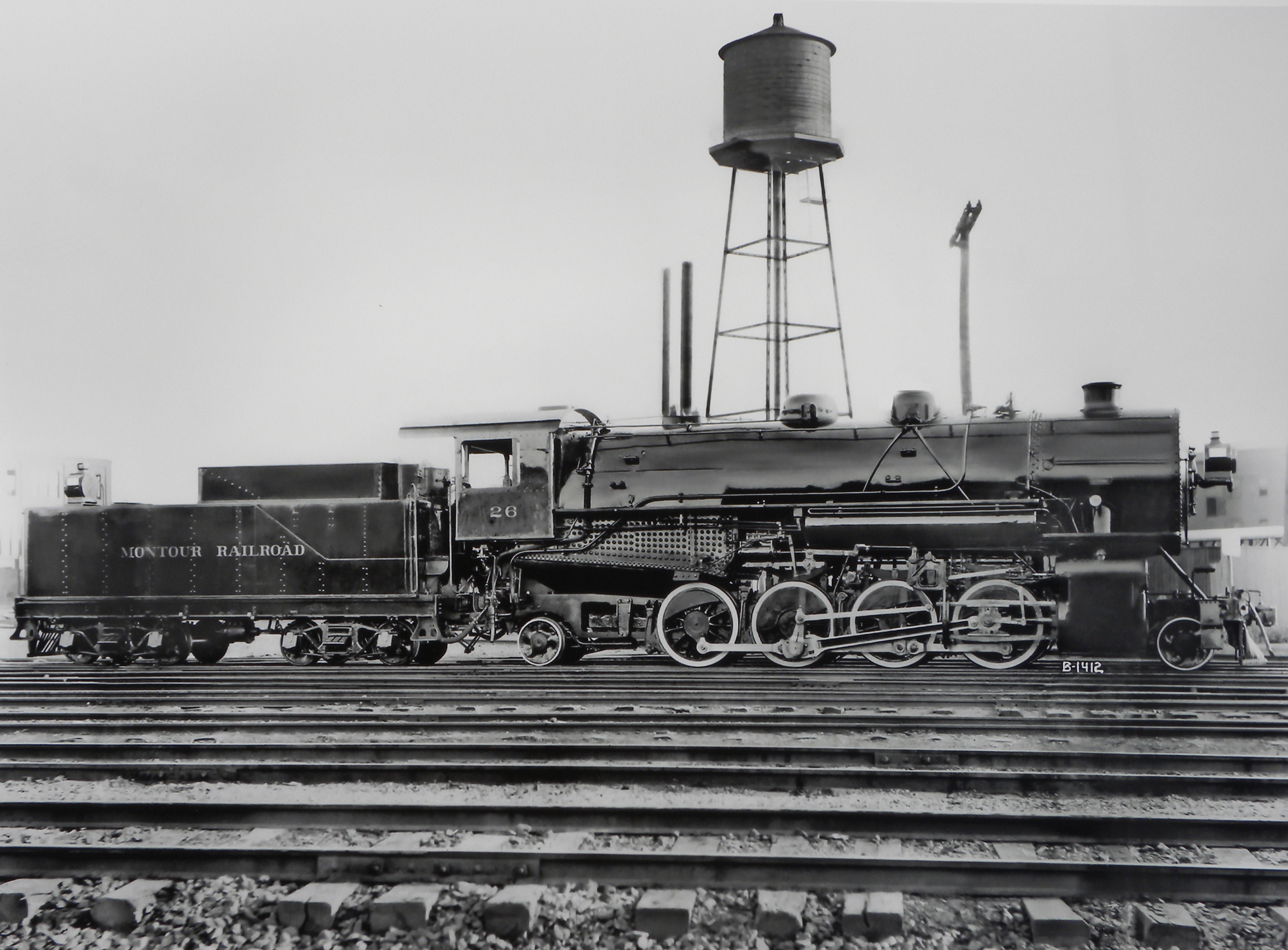
The Montour Railroad was a short line railroad company operating passenger and freight service in southwestern Pennsylvania. At its height in the 1930s, the railroad served 27 mines transporting nearly seven million tons of coal annually in Allegheny and Washington Counties. History The Montour Railroad Company was chartered in 1877 as a wholly owed subsidiary of the Imperial Coal Company. The first segment constructed extended from the Pittsburgh and Lake Erie Railroad line at Montour Junction, near Coraopolis, Pennsylvania to the Imperial Coal Company mines at Imperial, Pennsylvania. In 1901 the Pittsburgh Coal Company assumed control of the railroad. A major expansion was undertaken in 1912 to reach new coal mines and factories. By 1914 the railroad reached the town of West Mifflin, Pennsylvania on the Monongahela River. The Montour Railroad became an important feeder line and eventually all five major railroads in the southwestern Pennsylvania market were linked to the Mon ... [...More Info...] [...Related Items...] OR: [Wikipedia] [Google] [Baidu] |
Mining Town
A mining community, also known as a mining town or a mining camp, is a community that houses miners. Mining communities are usually created around a mine or a quarry. Historic mining communities Australia * Ballarat, Victoria * Bendigo, Victoria Austria *Schwaz *Eisenerz, Styria Former Austria-Hungary Upper Austrio-Hungarian mining towns *Göllnitz, today Gelnica *Jossau, today Jasov *Nemecká Ľupča, today Partizánska Ľupča *Schmöllnitz, today Smolník *Rosenau, today Rožňava *Ruda, today Rudabánya in Hungary *Telken, today Telkibánya in Hungary *Zipser Neudorf, today Spišská Nová Ves Lower Austrio-Hungarian mining towns *Dilln, today Banská Belá *Königsberg, today Nová Baňa *Kremnitz, today Kremnica *Libethen, today Ľubietová *Neusohl, today Banská Bystrica *Pukanz, today Pukanec *Schemnitz, today Banská Štiavnica Bosnia and Herzegovina * Banovići * Kakanj *Tuzla *Zenica Canada * Cobalt, Ontario * Glace Bay, Nova Scotia *Dawson ... [...More Info...] [...Related Items...] OR: [Wikipedia] [Google] [Baidu] |
Pittsburgh International Airport
Pittsburgh International Airport , formerly Greater Pittsburgh International Airport, is a civil–military international airport in Findlay Township and Moon Township, Pennsylvania. Located about 10 miles (15 km) west of downtown Pittsburgh, it is the primary international airport serving the Greater Pittsburgh Region as well as adjacent areas in West Virginia and Ohio. The airport is owned and operated by the Allegheny County Airport Authority and offers passenger flights to destinations throughout North America and Europe. PIT has four runways and covers . First opened in 1952, the airport was initially served by five airlines and became a small hub for Trans World Airlines for over two decades. The airport underwent a massive $1 billion rebuilding and expansion which was largely designed to US Airways' specification so it could become one of their major hubs. Completed in 1992, the new airport was one of the most innovative in the world, dubbed the "airport of the futur ... [...More Info...] [...Related Items...] OR: [Wikipedia] [Google] [Baidu] |
Findlay Township, Pennsylvania
Findlay Township is a township located west of Pittsburgh in Allegheny County, Pennsylvania, United States. The population was 6,370 at the 2020 census. The township is the home of Pittsburgh International Airport, which it shares with neighboring Moon Township to the east. Geography According to the United States Census Bureau, the township has a total area of , all of it land. Surrounding neighborhoods Findlay Township has four borders, including the townships of Moon to the east and northeast, North Fayette to the southeast, Robinson in Washington County to the southwest, and Independence in Beaver County to the northwest. Demographics As of the census of 2000, there were 5,145 people, 2,028 households, and 1,460 families residing in the township. The population density was 157.9 people per square mile (61.0/km2). There were 2,128 housing units at an average density of 65.3/sq mi (25.2/km2). The racial makeup of the township was 96.17% White, 1.63% African America ... [...More Info...] [...Related Items...] OR: [Wikipedia] [Google] [Baidu] |
North Fayette Township, Pennsylvania
North Fayette Township is a township in Allegheny County, Pennsylvania, United States. The township is a suburb of Pittsburgh. The population was 13,680 at the 2010 census. The township has been home to the Park Lane Office center since 1989. Geography According to the United States Census Bureau, the township has a total area of 27 square miles (65.0 km2), all of it land. Surrounding neighborhoods North Fayette Township has eight borders, including Findlay Township to the northwest, Robinson Township to the northeast, Moon Township to the north, Collier Township to the east, Oakdale and South Fayette Township to the southeast, McDonald to the south, and Robinson Township in Washington County from the southwest to the west. Economy The Pointe at North Fayette is located within the township and includes several retail plazas, big box stores, hotels, and office buildings. The Pointe at North Fayette sits adjacent to major shopping destinations Robinson Town Ce ... [...More Info...] [...Related Items...] OR: [Wikipedia] [Google] [Baidu] |
United States Census Bureau
The United States Census Bureau (USCB), officially the Bureau of the Census, is a principal agency of the U.S. Federal Statistical System, responsible for producing data about the American people and economy. The Census Bureau is part of the U.S. Department of Commerce and its director is appointed by the President of the United States. The Census Bureau's primary mission is conducting the U.S. census every ten years, which allocates the seats of the U.S. House of Representatives to the states based on their population. The bureau's various censuses and surveys help allocate over $675 billion in federal funds every year and it assists states, local communities, and businesses make informed decisions. The information provided by the census informs decisions on where to build and maintain schools, hospitals, transportation infrastructure, and police and fire departments. In addition to the decennial census, the Census Bureau continually conducts over 130 surveys and programs ... [...More Info...] [...Related Items...] OR: [Wikipedia] [Google] [Baidu] |


