|
Ik Kil
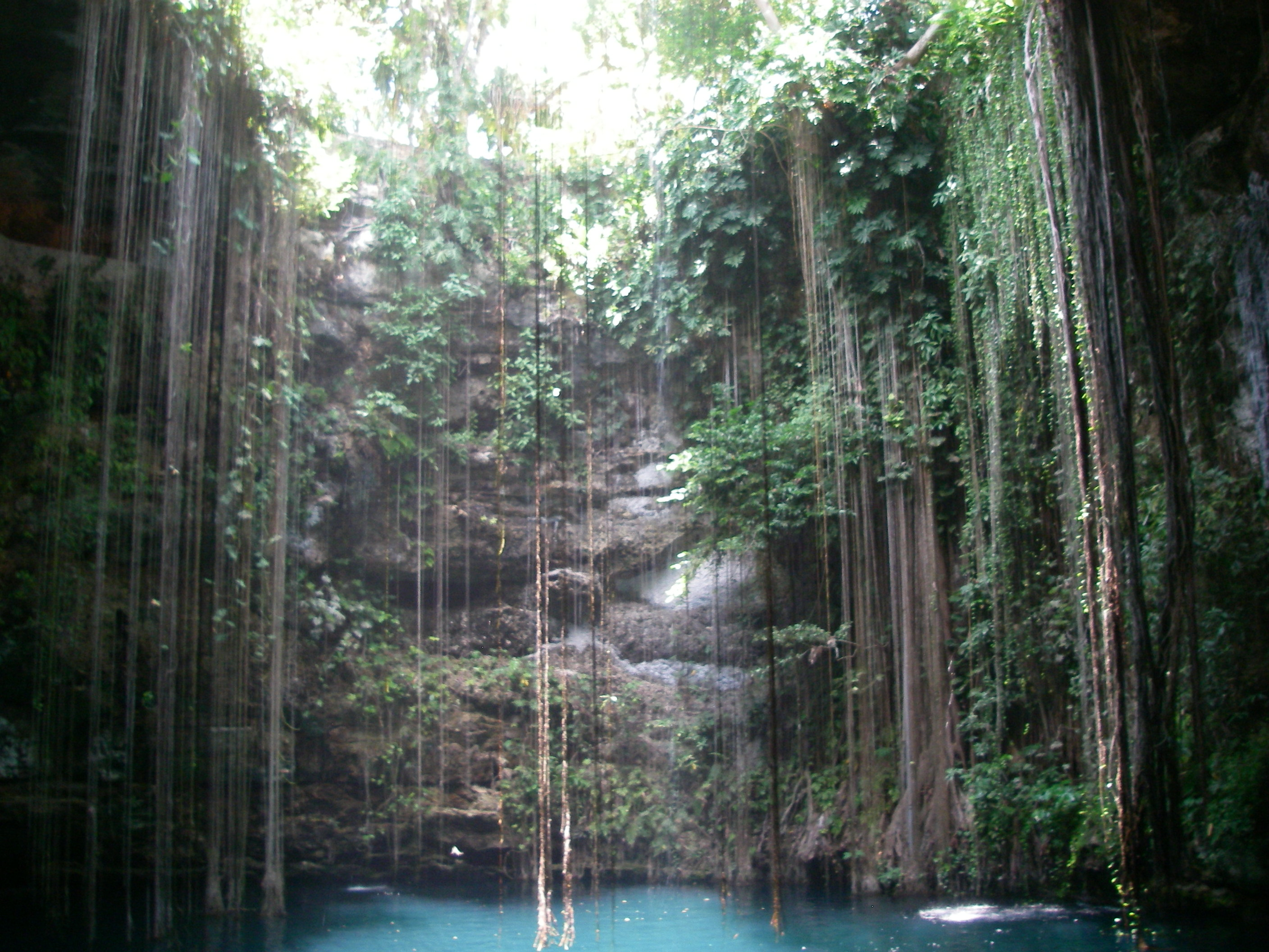
Ik Kil is a cenote outside Pisté in the Tinúm Municipality, Yucatán, Mexico. It is located in the northern center of the Yucatán Peninsula and is part of the Ik Kil Archeological Park near Chichen Itza. It is open to the public for swimming. Description The cenote is open to the sky with the water level about below ground level. There is a carved stairway that leads down to a swimming platform. The cenote is about in diameter and about deep. Cenote Ik Kil is near the Mayan ruins of Chichen Itza, on the highway to Valladolid. Ik Kil was considered sacred by the Mayans who used the site as a location for human sacrifice to their rain god, Chaac. Bones and pieces of jewelry were found in the deep waters of this cenote by archaeologists and speleologists. The cenote is part of a complex that includes a restaurant and hotel. [...More Info...] [...Related Items...] OR: [Wikipedia] [Google] [Baidu] |
Cenote
A cenote ( or ; ) is a natural pit, or sinkhole, resulting from the collapse of limestone bedrock that exposes groundwater. The regional term is specifically associated with the Yucatán Peninsula of Mexico, where cenotes were commonly used for water supplies by the ancient Maya, and occasionally for sacrificial offerings. The term derives from a word used by the lowland Yucatec Maya——to refer to any location with accessible groundwater. Similar rock-sided sinkholes like cenotes are common geological forms in low-altitude regions, particularly on islands, coastlines, and platforms with young post-Paleozoic limestone with little soil development. The term ''cenote'' has also been used to describe similar karst features in other countries such as Cuba and Australia. Definition and description Cenotes are surface connections to subterranean water bodies. While the best-known cenotes are large open-water pools measuring tens of meters in diameter, such as those at Chichen It ... [...More Info...] [...Related Items...] OR: [Wikipedia] [Google] [Baidu] |
Pisté, Yucatán
Pisté is a village in Tinum Municipality in the center of Yucatán State, Mexico. It is best known for the Mayan archaeological site Chichen Itza and the cenote Ik Kil. Fed 180 connects Pisté to Valladolid Valladolid () is a Municipalities of Spain, municipality in Spain and the primary seat of government and de facto capital of the Autonomous communities of Spain, autonomous community of Castile and León. It is also the capital of the province o ..., about away, and Mérida, the capital of Yucatán, about away. There are a variety of hotels serving the tourist sites. References Populated places in Yucatán Tourism in Mexico {{Yucatán-geo-stub ... [...More Info...] [...Related Items...] OR: [Wikipedia] [Google] [Baidu] |
Yucatán (state)
Yucatán (, also , , ; yua, Yúukatan ), officially the Free and Sovereign State of Yucatán,; yua, link=no, Xóot' Noj Lu'umil Yúukatan. is one of the 31 states which comprise the federal entities of Mexico. It comprises 106 separate municipalities, and its capital city is Mérida. It is located on the northern part of the Yucatán Peninsula. It is bordered by the states of Campeche to the southwest and Quintana Roo to the southeast, with the Gulf of Mexico off its northern coast. Before the arrival of Spaniards in the Yucatán Peninsula, the name of this region was ''Mayab''. In the Yucatec Maya language, ''mayab'' means "flat", and is the source of the word "Maya" itself. The peninsula was a very important region for the Maya civilization, which reached the peak of its development here, where the Mayans founded the cities of Chichen Itza, Izamal, Motul, Mayapan, Ek' Balam and Ichcaanzihóo (also called Ti'ho), now Mérida. After the Spanish conquest of Yucatán (e ... [...More Info...] [...Related Items...] OR: [Wikipedia] [Google] [Baidu] |
Mexico
Mexico (Spanish: México), officially the United Mexican States, is a country in the southern portion of North America. It is bordered to the north by the United States; to the south and west by the Pacific Ocean; to the southeast by Guatemala, Belize, and the Caribbean Sea; and to the east by the Gulf of Mexico. Mexico covers ,Mexico ''''. . making it the world's 13th-largest country by are ... [...More Info...] [...Related Items...] OR: [Wikipedia] [Google] [Baidu] |
Yucatán Peninsula
The Yucatán Peninsula (, also , ; es, Península de Yucatán ) is a large peninsula in southeastern Mexico and adjacent portions of Belize and Guatemala. The peninsula extends towards the northeast, separating the Gulf of Mexico to the north and west of the peninsula from the Caribbean Sea to the east. The Yucatán Channel, between the northeastern corner of the peninsula and Cuba, connects the two bodies of water. The peninsula is approximately in area. It has low relief, and is almost entirely composed of porous limestone. The peninsula lies east of the Isthmus of Tehuantepec, the narrowest point in Mexico separating the Atlantic Ocean, including the Gulf of Mexico and Caribbean Sea, from the Pacific Ocean. Some consider the isthmus to be the geographic boundary between Central America and the rest of North America, placing the peninsula in Central America. Politically all of Mexico, including the Yucatán, is generally considered part of North America, while Guatemala an ... [...More Info...] [...Related Items...] OR: [Wikipedia] [Google] [Baidu] |
Chichen Itza
Chichen Itza , es, Chichén Itzá , often with the emphasis reversed in English to ; from yua, Chiʼchʼèen Ìitshaʼ () "at the mouth of the well of the Itza people" was a large pre-Columbian city built by the Maya people of the Terminal Classic period. The archeological site is located in Tinúm Municipality, Yucatán State, Mexico. Chichen Itza was a major focal point in the Northern Maya Lowlands from the Late Classic (c. AD 600–900) through the Terminal Classic (c. AD 800–900) and into the early portion of the Postclassic period (c. AD 900–1200). The site exhibits a multitude of architectural styles, reminiscent of styles seen in central Mexico and of the Puuc and Chenes styles of the Northern Maya lowlands. The presence of central Mexican styles was once thought to have been representative of direct migration or even conquest from central Mexico, but most contemporary interpretations view the presence of these non-Maya styles more as the result of cultural ... [...More Info...] [...Related Items...] OR: [Wikipedia] [Google] [Baidu] |
Cenote En Chichén Itzá, Yucatán, México
A cenote ( or ; ) is a natural pit, or sinkhole, resulting from the collapse of limestone bedrock that exposes groundwater. The regional term is specifically associated with the Yucatán Peninsula of Mexico, where cenotes were commonly used for water supplies by the ancient Maya, and occasionally for sacrificial offerings. The term derives from a word used by the lowland Yucatec Maya——to refer to any location with accessible groundwater. Similar rock-sided sinkholes like cenotes are common geological forms in low-altitude regions, particularly on islands, coastlines, and platforms with young post-Paleozoic limestone with little soil development. The term ''cenote'' has also been used to describe similar karst features in other countries such as Cuba and Australia. Definition and description Cenotes are surface connections to subterranean water bodies. While the best-known cenotes are large open-water pools measuring tens of meters in diameter, such as those at Chichen It ... [...More Info...] [...Related Items...] OR: [Wikipedia] [Google] [Baidu] |
Valladolid, Yucatán
Valladolid (; Saki in Maya) is a city located in the eastern region of the Mexican state of Yucatán. It is the seat of Valladolid Municipality. As of the 2020 census the population of the city was 56,494 inhabitants (the third-largest community in the state after Kanasín), and that of the municipality was 85,460. The municipality has an areal extent of 945.22 km2 (364.95 sq mi) and includes many outlying communities, the largest of which are Popolá, Kanxoc, Yalcobá, and Xocén. Valladolid is located approximately 170 km (105 mi) east of the state capital Mérida, 40 km (25 mi) east of Chichén Itzá, and 150 km (93 mi) west of Cancún. On August 30, 2012, Valladolid became part of the ''Pueblo Mágico'' promotional initiative led by the Mexican tourism department. History Named after Valladolid, at the time the capital of Spain. The name derives from the Arabic name Balad al-Walid بلد الوليد, which means "city of al-Walid", referr ... [...More Info...] [...Related Items...] OR: [Wikipedia] [Google] [Baidu] |
Chaac
Chaac (also spelled Chac or, in Classic Mayan, Chaahk ) is the name of the Maya god of rain, thunder, and lighting. With his lightning axe, Chaac strikes the clouds, causing them to produce thunder and rain. Chaac corresponds to Tlaloc among the Aztecs. Rain deities and rain makers Like other Maya gods, Chaac is both one and manifold. Four Chaacs are based in the cardinal directions and wear the directional colors. In 16th-century Yucatán, the directional Chaac of the east was called ''Chac Xib Chaac'' 'Red Man Chaac', only the colors being varied for the three other ones. Contemporary Yucatec Maya farmers distinguish many more aspects of the rainfall and the clouds and personify them as different, hierarchically-ordered rain deities. The Chorti Maya have preserved important folklore regarding the process of rain-making, which involved rain deities striking rain-carrying snakes with their axes. The rain deities had their human counterparts. In the traditional Mayan (and ... [...More Info...] [...Related Items...] OR: [Wikipedia] [Google] [Baidu] |
Red Bull Cliff Diving World Series
The Red Bull Cliff Diving World Series, established in 2009 and created by Red Bull, is an annual international series of cliff diving events in which a limited number of competitors determine the Cliff Diving World Series winner. Divers jump from a platform at a height ranging from 26 to 28 m (85–92 ft). Competitions are held in a limited number of venues around the globe. Tour ranking Every athlete scores a number of points in every competition as distributed here: Points system from 2012 In 2012 the Series introduced a new point system that was continued to be used also during the 2013 season. Cliff Diving World Series champion is the athlete who scored the highest cumulated number of points in all competitions during the season. The top 6 divers in the overall ranking at the end of the season will pre-qualify automatically for the next season. Previous winners Men Women Tour events 1 Divers jumped at 4 different sites: Wang Long Bay ... [...More Info...] [...Related Items...] OR: [Wikipedia] [Google] [Baidu] |
Mexico Cave Steps
Mexico (Spanish: México), officially the United Mexican States, is a country in the southern portion of North America. It is bordered to the north by the United States; to the south and west by the Pacific Ocean; to the southeast by Guatemala, Belize, and the Caribbean Sea; and to the east by the Gulf of Mexico. Mexico covers ,Mexico ''''. . making it the world's 13th-largest country by are ... [...More Info...] [...Related Items...] OR: [Wikipedia] [Google] [Baidu] |


.png)

