|
Ifrane, Morocco
Ifrane (Berber: ⵉⴼⵔⴰⵏ; ar, إفران) is a city in the Middle Atlas region of northern Morocco (population 14,659 as of November 2014). The capital of Ifrane Province in the region of Fès-Meknès, Ifrane is located at an elevation of . "Climatological Information for Ifrane, Morocco", Hong Kong Observatory, 2003, web: -->mor_al/infrane_e.htm HKO-Ifrane In the regional Tamazight language, "ifran" means ''caves''. The modern town of Ifrane was established by the French administration in 1928 during the protectorate era for their administration due to its Alpine climate. Ifrane was conceived as a "hill station" or colonial type of settlement. It is a resort town set high up in the mountains so that Europeans could find relief from the summer heat of the interior plains of Morocco. Ifrane is also a popular altitude training destination. The first permanent settlement of the area dates to the 16th century, when the Sharif of Sîdî 'Abd al-Salâm established his ... [...More Info...] [...Related Items...] OR: [Wikipedia] [Google] [Baidu] |
Barbary Macaque
The Barbary macaque (''Macaca sylvanus''), also known as Barbary ape, is a macaque species native to the Atlas Mountains of Algeria, Libya, Tunisia and Morocco, along with a small introduced population in Gibraltar. It is the type species of the genus ''Macaca''. The species is of particular interest because males play an atypical role in rearing young. Because of uncertain paternity, males are integral to raising all infants. Generally, Barbary macaques of all ages and sexes contribute in alloparental care of young. The diet of the Barbary macaque consists primarily of plants and insects and they are found in a variety of habitats. Males live to around 25 years old while females may live up to 30 years. Besides humans, they are the only free-living primates in Europe. Although the species is commonly referred to as the "Barbary ape", the Barbary macaque is actually a true monkey. Its name refers to the Barbary Coast of Northwest Africa. The population of the Barbary macaques i ... [...More Info...] [...Related Items...] OR: [Wikipedia] [Google] [Baidu] |
Garden City Movement
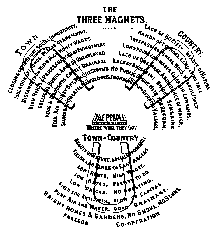
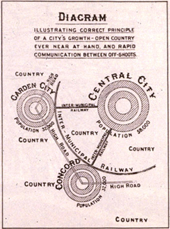
The garden city movement was a 20th century urban planning movement promoting satellite communities surrounding the central city and separated with greenbelts. These Garden Cities would contain proportionate areas of residences, industry, and agriculture. Ebenezer Howard first posited the idea in 1898 as a way to capture the primary benefits of the countryside and the city while avoiding the disadvantages presented by both. In the early 20th century, Letchworth, Brentham Garden Suburb and Welwyn Garden City were built in or near London according to Howard's concept and many other garden cities inspired by his model have since been built all over the world. History Conception Inspired by the utopian novel ''Looking Backward'' and Henry George's work ''Progress and Poverty'', Howard published the book '': a Peaceful Path to Real Reform'' in 1898 (which was reissued in 1902 as ''Garden Cities of To-morrow''). His idealised garden city would house 32,000 people on a site of , pl ... [...More Info...] [...Related Items...] OR: [Wikipedia] [Google] [Baidu] |
Bou Regreg
The Bou Regreg ( ar, أبو رقراق) is a river located in western Morocco which discharges to the Atlantic Ocean between the cities of Rabat and Salé. The estuary of this river is termed Wadi Sala. The river is 240 kilometres long, with a tidal estuary of approximately 24 kilometres extending upriver. Its average discharge is 23 m3/s and can reach 1500 m3/s during periods of flooding. The source of the river originates from the Middle Atlas mountains at an altitude of 1627 meters on the level of Jbel Mtourzgane (Province of Khemisset) and of Grou (Province of Khénifra) and descends to its mouth at the Atlantic Ocean separating the cities of Rabat to the south and Salé to the north. Water quality Water quality issues of the Bou Regreg include tidal saltwater intrusion, excessive runoff of nitrates from agricultural land uses and mercury contamination thought to arise from use of certain pesticides within the drainage basin. History The Phoenicians and the Carthaginians ... [...More Info...] [...Related Items...] OR: [Wikipedia] [Google] [Baidu] |
Sebou River
Sebou (Berber language, Berber: Asif en Sbu, ar, سبو) is a river in northern Morocco. At its source in the Middle Atlas mountains it is known as the Guigou River (Berber: Asif n Gigu). The river is 496 kilometers long and has an average water flow of 137 m3/s, which makes it the largest North African river by volume. It passes near the city of Fes, Morocco, Fes and discharges to the Atlantic Ocean at Mehdya, Morocco, Mehdya. Sebou is navigable for only 16 km as far as the city of Kenitra, which has the only river port in Morocco. Its most important tributaries are the Ouergha River, Baht River and Inaouen River. The river supports irrigation in Morocco's most fertile region: the Gharb-Chrarda-Béni Hssen, Gharb. History Sebou was known in antiquity as Sububus. Pliny the Elder states that it was "magnificus et navigabilis" (grand and navigable), flowing near the towns of Iulia Valentia Banasa, Banasa (near the city of Mechra Bel Ksiri) and Thamusida. There is scant hist ... [...More Info...] [...Related Items...] OR: [Wikipedia] [Google] [Baidu] |
Moulouya
The Moulouya River (Berber language, Berber: ''iɣẓer en Melwect'', ) is a 520 km-long river in Morocco. Its sources are located in the Jbel Ayachi, Ayashi mountain in the Middle Atlas. It empties into the Mediterranean Sea near Saïdia, in northeast Morocco. Water level in the river often fluctuates. The river is used for irrigation and is dammed by the Hassan II Dam, Hassan II and Mohamed V Dams. History Before French colonisation, the Moulouya River was considered as the border between Ottoman Algeria and the dynasties that controlled Morocco. A Battle of Moulouya, battle between the Algerians and the Alawites took place in 1692 at the ford of this river. The Romans called this river ''River Malvam, Malva''. In medieval British pseudo-history, it was mentioned as a location along the route supposedly travelled by the ancestors of the Scotti, and by Brutus of Troy. The Moulouya River formed the eastern border of the kingdom of Mauretania since King Bocchus I, and more r ... [...More Info...] [...Related Items...] OR: [Wikipedia] [Google] [Baidu] |
Cèdre Gouraud Forest
Cèdre Gouraud Forest is a woodland area in the Middle Atlas Mountain Range in Morocco. It was named for the French general Henri Gouraud. This forest is located on National Route 8 between Azrou and Ifrane. The forest is notable as a habitat for a sub-population of Barbary macaques, ''Macaca sylvanus''.C. Michael Hogan, 2008 See also * Atlas cedar * Atlas Mountains The Atlas Mountains are a mountain range in the Maghreb in North Africa. It separates the Sahara Desert from the Mediterranean Sea and the Atlantic Ocean; the name "Atlantic" is derived from the mountain range. It stretches around through Moroc ... * Mediterranean woodlands and forests References * C. Michael Hogan, (2008''Barbary Macaque: Macaca sylvanus'', Globaltwitcher.com, ed. Nicklas Stromberg* Justin McGuinness (2003) ''Morocco: The Travel Guide'', Footprint Press Travel Guides, 560 pages Line notes Mediterranean forests, woodlands, and scrub Forests of Morocco Geography of Fès-Meknès {{D ... [...More Info...] [...Related Items...] OR: [Wikipedia] [Google] [Baidu] |
Limestone
Limestone ( calcium carbonate ) is a type of carbonate sedimentary rock which is the main source of the material lime. It is composed mostly of the minerals calcite and aragonite, which are different crystal forms of . Limestone forms when these minerals precipitate out of water containing dissolved calcium. This can take place through both biological and nonbiological processes, though biological processes, such as the accumulation of corals and shells in the sea, have likely been more important for the last 540 million years. Limestone often contains fossils which provide scientists with information on ancient environments and on the evolution of life. About 20% to 25% of sedimentary rock is carbonate rock, and most of this is limestone. The remaining carbonate rock is mostly dolomite, a closely related rock, which contains a high percentage of the mineral dolomite, . ''Magnesian limestone'' is an obsolete and poorly-defined term used variously for dolomite, for limes ... [...More Info...] [...Related Items...] OR: [Wikipedia] [Google] [Baidu] |
Chalet
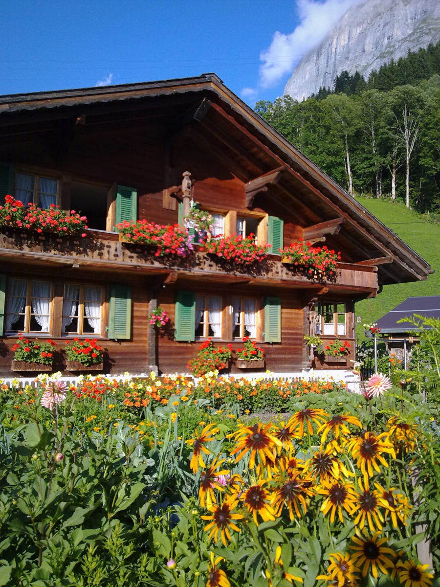
A chalet (pronounced in British English; in American English usually ), also called Swiss chalet, is a type of building or house, typical of the Alpine region in Europe. It is made of wood, with a heavy, gently sloping roof and wide, well-supported eaves set at right angles to the front of the house. Definition and origin The term ''chalet'' comes from the Arpitan-speaking part of Switzerland and the French Savoy region, and originally referred to the hut of a herder. It was often embedded in the ground for the sake of temperature buffering. Many chalets in the European Alps were originally used as seasonal farms for dairy cattle, which would be brought up from the lowland pastures during the summer months. The herders would live in the chalet and make butter and cheese in order to preserve the milk produced. These products would then be taken, with the cattle, back to the low valleys before the onset of the alpine winter. The chalets would remain locked and unused during t ... [...More Info...] [...Related Items...] OR: [Wikipedia] [Google] [Baidu] |
Public Housing
Public housing is a form of housing tenure in which the property is usually owned by a government authority, either central or local. Although the common goal of public housing is to provide affordable housing, the details, terminology, definitions of poverty, and other criteria for allocation vary within different contexts. Public housing developments are classified as housing projects that are owned by a city's Housing authority or Federally subsidized public housing operated through HUD. Social housing is any rental housing that may be owned and managed by the state, by non-profit organizations, or by a combination of the two, usually with the aim of providing affordable housing. Social housing is generally rationed by a government through some form of means-testing or through administrative measures of housing need. One can regard social housing as a potential remedy for housing inequality. Private housing is a form of housing tenure in which the property is owned by an i ... [...More Info...] [...Related Items...] OR: [Wikipedia] [Google] [Baidu] |
Garden City Movement
The garden city movement was a 20th century urban planning movement promoting satellite communities surrounding the central city and separated with greenbelts. These Garden Cities would contain proportionate areas of residences, industry, and agriculture. Ebenezer Howard first posited the idea in 1898 as a way to capture the primary benefits of the countryside and the city while avoiding the disadvantages presented by both. In the early 20th century, Letchworth, Brentham Garden Suburb and Welwyn Garden City were built in or near London according to Howard's concept and many other garden cities inspired by his model have since been built all over the world. History Conception Inspired by the utopian novel ''Looking Backward'' and Henry George's work ''Progress and Poverty'', Howard published the book '': a Peaceful Path to Real Reform'' in 1898 (which was reissued in 1902 as ''Garden Cities of To-morrow''). His idealised garden city would house 32,000 people on a site of , pl ... [...More Info...] [...Related Items...] OR: [Wikipedia] [Google] [Baidu] |
Zâwiya
A ''zawiya'' or ''zaouia'' ( ar, زاوية, lit=corner, translit=zāwiyah; ; also spelled ''zawiyah'' or ''zawiyya'') is a building and institution associated with Sufis in the Islamic world. It can serve a variety of functions such a place of worship, school, monastery and/or mausoleum. In some regions the term is interchangeable with the term ''khanqah'', which serves a similar purpose. In the Maghreb, the term is often used for a place where the founder of a Sufi order or a local saint or holy man (e.g. a '' wali'') lived and was buried. In the Maghreb the word can also be used to refer to the wider ''tariqa'' (Sufi order or brotherhood) and its membership. Maghreb Religious and social functions In the Maghreb (Morocco, Algeria, Tunisia and Libya) the zawiya is primarily a place for religious activities and religious instruction. It is typically associated with a particular religious leader (''shaykh'') or a local Muslim saint (''wali''), who is housed here along with h ... [...More Info...] [...Related Items...] OR: [Wikipedia] [Google] [Baidu] |


.jpg)