|
Hurricane Gaston (2004)
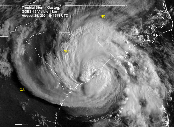
Hurricane Gaston was a minimal hurricane that made landfall in South Carolina on August 29, 2004. It then crossed North Carolina and Virginia before exiting to the northeast and dissipating. The storm killed nine people – eight of them directly – and caused $130 million (2004 USD) in damage. Gaston produced torrential downpours that inundated Richmond, Virginia. Although originally designated a tropical storm, Gaston was reclassified as a hurricane when post-storm analysis revealed it had maximum sustained winds of 75 mph (120 km/h). Meteorological history On August 22, 2004, a cold front—the same front which eventually spawned Tropical Storm Hermine—moved off the coast of the Carolinas and drifted southward before stalling on August 24. On August 25, Surface observations indicated that a broad low pressure area developed along the deteriorating frontal boundary. Convection remained sporadic and disorganized, until thunderstorm activity began to incr ... [...More Info...] [...Related Items...] OR: [Wikipedia] [Google] [Baidu] |
South Carolina
)''Animis opibusque parati'' ( for, , Latin, Prepared in mind and resources, links=no) , anthem = " Carolina";" South Carolina On My Mind" , Former = Province of South Carolina , seat = Columbia , LargestCity = Charleston , LargestMetro = Greenville (combined and metro) Columbia (urban) , BorderingStates = Georgia, North Carolina , OfficialLang = English , population_demonym = South Carolinian , Governor = , Lieutenant Governor = , Legislature = General Assembly , Upperhouse = Senate , Lowerhouse = House of Representatives , Judiciary = South Carolina Supreme Court , Senators = , Representative = 6 Republicans1 Democrat , postal_code = SC , TradAbbreviation = S.C. , area_rank = 40th , area_total_sq_mi = 32,020 , area_total_km2 = 82,932 , area_land_sq_mi = 30,109 , area_land_km2 = 77,982 , area_water_sq_mi = 1,911 , area_water_km2 = 4,949 , area_water_percent = 6 , population_rank = 23rd , population_as_of = 2022 , 2010Pop = 5282634 , population ... [...More Info...] [...Related Items...] OR: [Wikipedia] [Google] [Baidu] |
Awendaw, South Carolina
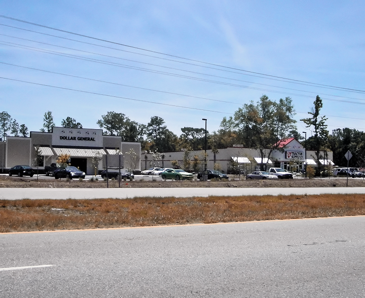
Awendaw is a small fishing town in Charleston County, South Carolina, United States. The population was 1,294 at the 2010 census. Awendaw is part of the Charleston, South Carolina metropolitan area. History Awendaw was named by the Sewee tribe. Awendaw is thought to mean "Red Clay". It is also home to an oyster shell mound created by the Sewee tribe. It is the northernmost shell ring in a group that stretches south to the tip of Florida. Most of the mound is still intact. The rest of it was destroyed to construct roads and homes for the citizens of Awendaw. Awendaw was settled in 1696 as Wappetaw by settlers from Salem, Massachusetts, who had left after the Salem Witch Trials. The town was heavily damaged by Hurricane Hugo in September 1989, but did not receive as significant damage in 2004 when Hurricane Gaston made landfall in the region. In 1992, the town of Awendaw was first incorporated and elected Willam H. Alston as the first mayor. Alston served as mayor until 2009. Th ... [...More Info...] [...Related Items...] OR: [Wikipedia] [Google] [Baidu] |
Joseph P
Joseph is a common male given name, derived from the Hebrew Yosef (יוֹסֵף). "Joseph" is used, along with "Josef", mostly in English, French and partially German languages. This spelling is also found as a variant in the languages of the modern-day Nordic countries. In Portuguese and Spanish, the name is "José". In Arabic, including in the Quran, the name is spelled '' Yūsuf''. In Persian, the name is "Yousef". The name has enjoyed significant popularity in its many forms in numerous countries, and ''Joseph'' was one of the two names, along with ''Robert'', to have remained in the top 10 boys' names list in the US from 1925 to 1972. It is especially common in contemporary Israel, as either "Yossi" or "Yossef", and in Italy, where the name "Giuseppe" was the most common male name in the 20th century. In the first century CE, Joseph was the second most popular male name for Palestine Jews. In the Book of Genesis Joseph is Jacob's eleventh son and Rachel's first son, and k ... [...More Info...] [...Related Items...] OR: [Wikipedia] [Google] [Baidu] |
Barrier Island
Barrier islands are coastal landforms and a type of Dune, dune system that are exceptionally flat or lumpy areas of sand that form by wave and tidal action parallel to the mainland coast. They usually occur in chains, consisting of anything from a few islands to more than a dozen. They are subject to change during storms and other action, but absorb energy and protect the coastlines and create areas of protected waters where wetlands may flourish. A barrier chain may extend uninterrupted for over a hundred kilometers, excepting the tidal inlets that separate the islands, the longest and widest being Padre Island of Texas, United States. Sometimes an important inlet may close permanently, transforming an island into a peninsula, thus creating a barrier peninsula, often including a beach, barrier beach. The length and width of barriers and overall morphology of barrier coasts are related to parameters including tidal range, wave energy, Sediment transport, sediment supply, Sea leve ... [...More Info...] [...Related Items...] OR: [Wikipedia] [Google] [Baidu] |
Little River (Horry County, South Carolina)
The Little River flows through Little River, South Carolina, briefly touching the border with North Carolina before emptying into the Atlantic Ocean at the Little River Inlet. A large portion of the river forms part of the Atlantic Intracoastal Waterway. Due to USGS weather buoy off Little River Inlet, the Little River Inlet is often referred to in weather forecasts. See also * List of rivers in North Carolina * List of rivers in South Carolina *Waterways forming and crossings of the Atlantic Intracoastal Waterway This is a list of waterways that form the Atlantic Intracoastal Waterway, sometimes called the Intracoastal Canal, and crossings (bridges, tunnels and ferries) of it. Florida * Florida Bay * Baker Cut (manmade) * Buttonwood Sound * Groupe ... References Rivers of Horry County, South Carolina Rivers of North Carolina Rivers of South Carolina {{SouthCarolina-river-stub ... [...More Info...] [...Related Items...] OR: [Wikipedia] [Google] [Baidu] |
Savannah River
The Savannah River is a major river in the southeastern United States, forming most of the border between the states of South Carolina and Georgia. Two tributaries of the Savannah, the Tugaloo River and the Chattooga River, form the northernmost part of the border. The Savannah River drainage basin extends into the southeastern side of the Appalachian Mountains just inside North Carolina, bounded by the Eastern Continental Divide. The river is around long.U.S. Geological Survey. National Hydrography Dataset high-resolution flowline dataThe National Map, accessed April 26, 2011 The Savannah was formed by the confluence of the Tugaloo River and the Seneca River. Today this confluence is submerged beneath Lake Hartwell. The Tallulah Gorge is located on the Tallulah River, a tributary of the Tugaloo River that forms the northwest branch of the Savannah River. Two major cities are located along the Savannah River: Savannah and Augusta, Georgia. They were nuclei of early Eng ... [...More Info...] [...Related Items...] OR: [Wikipedia] [Google] [Baidu] |
Fernandina Beach, Florida
Fernandina Beach is a city in northeastern Florida and the county seat of Nassau County, Florida, Nassau County, Florida, United States. It is the northernmost city on Florida's Atlantic coast, situated on Amelia Island, and is one of the principal municipalities comprising Greater Jacksonville. The area was first inhabited by the Timucuan Indian people. Known as the "Isle of 8 Flags", Amelia Island has had the flags of the following nations flown over it: France, Spain, Great Britain, Spain (again), the Republic of East Florida (1812), the Republic of the Floridas (1817), Mexico, the Confederate States of America, and the United States. The French, English, and Spanish all maintained a presence on Amelia Island at various times during the 16th, 17th, and 18th centuries, but the Spanish established Fernandina. The town of Fernandina, which was about a mile from the present city, was named in honor of King Ferdinand VII of Spain by the governor of the Spanish province of East Flor ... [...More Info...] [...Related Items...] OR: [Wikipedia] [Google] [Baidu] |
Surf City, North Carolina
Surf City is a town in Pender and Onslow counties in the U.S. state of North Carolina. The population was 1,853 at the 2010 census. It is located on Topsail Island. The Pender County portion of Surf City is part of the Wilmington Metropolitan Statistical Area, while the Onslow County portion is part of the Jacksonville Metropolitan Statistical Area. Geography Surf City is located at (34.428137, -77.543198). According to the United States Census Bureau, Surf City has a total area of 5.3 square miles (13.7 km), of which 4.2 square miles (10.9 km) is land and 1.1 square miles (2.8 km) (20.45%) is water. Recent annexations have extended the town limits on the mainland west of Highway 17. Climate Demographics 2020 census As of the 2020 United States census, there were 3,867 people, 1,272 households, and 870 families residing in the town. 2000 census As of the census of 2000 there were 1,393 people, 689 households, and 403 families residi ... [...More Info...] [...Related Items...] OR: [Wikipedia] [Google] [Baidu] |
Reykjavík
Reykjavík ( ; ) is the capital and largest city of Iceland. It is located in southwestern Iceland, on the southern shore of Faxaflói bay. Its latitude is 64°08' N, making it the world's northernmost capital of a sovereign state. With a population of around 131,136 (and 233,034 in the Capital Region), it is the centre of Iceland's cultural, economic, and governmental activity, and is a popular tourist destination. Reykjavík is believed to be the location of the first permanent settlement in Iceland, which, according to Landnámabók, was established by Ingólfr Arnarson in 874 CE. Until the 18th century, there was no urban development in the city location. The city was officially founded in 1786 as a trading town and grew steadily over the following decades, as it transformed into a regional and later national centre of commerce, population, and governmental activities. It is among the cleanest, greenest, and safest cities in the world. History According to lege ... [...More Info...] [...Related Items...] OR: [Wikipedia] [Google] [Baidu] |
Nova Scotia
Nova Scotia ( ; ; ) is one of the thirteen provinces and territories of Canada. It is one of the three Maritime provinces and one of the four Atlantic provinces. Nova Scotia is Latin for "New Scotland". Most of the population are native English-speakers, and the province's population is 969,383 according to the 2021 Census. It is the most populous of Canada's Atlantic provinces. It is the country's second-most densely populated province and second-smallest province by area, both after Prince Edward Island. Its area of includes Cape Breton Island and 3,800 other coastal islands. The Nova Scotia peninsula is connected to the rest of North America by the Isthmus of Chignecto, on which the province's land border with New Brunswick is located. The province borders the Bay of Fundy and Gulf of Maine to the west and the Atlantic Ocean to the south and east, and is separated from Prince Edward Island and the island of Newfoundland by the Northumberland and Cabot straits, ... [...More Info...] [...Related Items...] OR: [Wikipedia] [Google] [Baidu] |
Extratropical Cyclone
Extratropical cyclones, sometimes called mid-latitude cyclones or wave cyclones, are low-pressure areas which, along with the anticyclones of high-pressure areas, drive the weather over much of the Earth. Extratropical cyclones are capable of producing anything from cloudiness and mild showers to severe gales, thunderstorms, blizzards, and tornadoes. These types of cyclones are defined as large scale (synoptic) low pressure weather systems that occur in the middle latitudes of the Earth. In contrast with tropical cyclones, extratropical cyclones produce rapid changes in temperature and dew point along broad lines, called weather fronts, about the center of the cyclone. Terminology The term " cyclone" applies to numerous types of low pressure areas, one of which is the extratropical cyclone. The descriptor ''extratropical'' signifies that this type of cyclone generally occurs outside the tropics and in the middle latitudes of Earth between 30° and 60° latitude. They are term ... [...More Info...] [...Related Items...] OR: [Wikipedia] [Google] [Baidu] |
Delmarva Peninsula
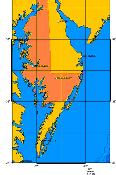
The Delmarva Peninsula, or simply Delmarva, is a large peninsula and proposed state on the East Coast of the United States, occupied by the vast majority of the state of Delaware and parts of the Eastern Shore regions of Maryland and Virginia. The peninsula is long. In width, it ranges from near its center, to at the isthmus on its northern edge, to less near its southern tip of Cape Charles. It is bordered by the Chesapeake Bay on the west, Pocomoke Sound on the southwest, and the Delaware River, Delaware Bay, and the Atlantic Ocean on the east. Etymology In older sources, the peninsula between Delaware Bay and Chesapeake Bay was referred to variously as the Delaware and Chesapeake Peninsula or simply the Chesapeake Peninsula. The toponym ''Delmarva'' is a clipped compound of Delaware, Maryland, and Virginia ( official abbreviation ''VA''), which in turn was modeled after Delmar, a border town named after two of those states. While Delmar was founded and named in 1859, ... [...More Info...] [...Related Items...] OR: [Wikipedia] [Google] [Baidu] |


.jpg)


