|
Hube (ridge)
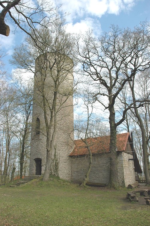
The Hube is a ridge, up to , in the Leine Uplands and district of Northeim, in the German state of Lower Saxony. Geography The densely wooded Hube lies immediately northeast of the town of Einbeck, with its pretty, timber-framed houses, west of the River Leine and north of the Ilme valley. Although the ridge, which measures some 8.5 x 5.5 kilometres, is west of the Leine it is counted as part of the southwestern Harz Foreland in Germany's official natural regional classification. The highest elevation on the Hube is the Fuchshöhlenberg with its transmission mast at 346.2 m. About 150 metres southeast of the tower is the highest point of the actual summit. On the northern edge of the Greene Forest, the northern part of the Hube, are the ruins of Greene Castle above the town of Greene with good views from the castle tower. In the southern part of the Hube, 570 metres north of the Altendorfer Berg and between Einbeck and Negenborn stands the Emperor Fred ... [...More Info...] [...Related Items...] OR: [Wikipedia] [Google] [Baidu] |
Grubenhagen Castle (Einbeck)
Grubenhagen Castle (german: Burg Grubenhagen) is a ruined medieval castle in North Germany dating to the 13th century. It is not far from the town of Einbeck in southern Lower Saxony. Location The ruins are located in the district of Northeim on a hill summit on the Ahlsburg ridge, south-southwest of Einbeck and east of the Solling hills, between the basin of the River Ilme and the valley of the Leine. The castle may be reached via a narrow forest path from Rotenkirchen, a village south of Einbeck, which is on the northern edge of the ridge and below the castle ruins and not far to the northeast. Architecture The hill castle of Grubenhagen was built in the 13th century. Only the round, bergfried remains today. Attached to its southeastern side is a building from the 19th/20th century. The raised plateau of the inner ward, with its relatively small area, is oval and slightly kidney-shaped. It is about 63 metres long and 32 metres wide. Below it is the outer ward. The site ... [...More Info...] [...Related Items...] OR: [Wikipedia] [Google] [Baidu] |
Kreiensen
Kreiensen is a village and a former municipality in the district of Northeim, in Lower Saxony, Germany. Since 1 January 2013, it is part of the town Einbeck. Geography Kreiensen is situated on the river Leine, approx. north of Northeim, and south of Hildesheim. It lies in southern Niedersachsen in the foothills of the Harz and Solling Mountains. On the north are the heights of the Helleberg, on the southwest the Hube, and on the northwest the Selter. The Gande, a northeastern tributary of the Leine, flows through the center of Kreiensen. Religion The Roman Catholic church building stems from 1967. The evangelical lutheran church was built in Nazi Germany in 1935 as one of a few examples of those times. Transport Kreiensen railway station is known as a railroad hub with five lines interchanging. In 1865, Altenbeken–Kreiensen railway was connected with Hanoverian Southern Railway that already existed. One year thereafter, Vienenburg–Goslar railway was connected. Betw ... [...More Info...] [...Related Items...] OR: [Wikipedia] [Google] [Baidu] |
Normalnull
("standard zero") or (short N. N. or NN ) is an outdated official vertical datum used in Germany. Elevations using this reference system were to be marked (“meters above standard zero”). has been replaced by (NHN). History In 1878 reference heights were taken from the Amsterdam Ordnance Datum and transferred to the New Berlin Observatory in order to define the . has been defined as a level going through an imaginary point 37.000 m below . When the New Berlin Observatory was demolished in 1912 the reference point was moved east to the village of Hoppegarten (now part of the town of Müncheberg, Brandenburg, Germany Germany,, officially the Federal Republic of Germany, is a country in Central Europe. It is the second most populous country in Europe after Russia, and the most populous member state of the European Union. Germany is situated betwe ...).S. German: ''Was ist "Normal-Null"?''. In: ''Physikalische Blätter'' 1958, vol 14, issue 2, p. ... [...More Info...] [...Related Items...] OR: [Wikipedia] [Google] [Baidu] |
Bunter Sandstone
The Buntsandstein (German for ''coloured'' or ''colourful sandstone'') or Bunter sandstone is a lithostratigraphic and allostratigraphic unit (a sequence of rock strata) in the subsurface of large parts of west and central Europe. The Buntsandstein predominantly consists of sandstone layers of the Lower Triassic series and is one of three characteristic Triassic units, together with the Muschelkalk and Keuper that form the Germanic Trias Supergroup. The Buntsandstein is similar in age, facies and lithology with the Bunter of the British Isles. It is normally lying on top of the Permian Zechstein and below the Muschelkalk. In the past the name Buntsandstein was in Europe also used in a chronostratigraphic sense, as a subdivision of the Triassic system. Among reasons to abandon this use was the discovery that its base lies actually in the latest Permian. Origin The Buntsandstein was deposited in the Germanic Basin, a large sedimentary basin that was the successor of the smal ... [...More Info...] [...Related Items...] OR: [Wikipedia] [Google] [Baidu] |


