|
Hotellneset
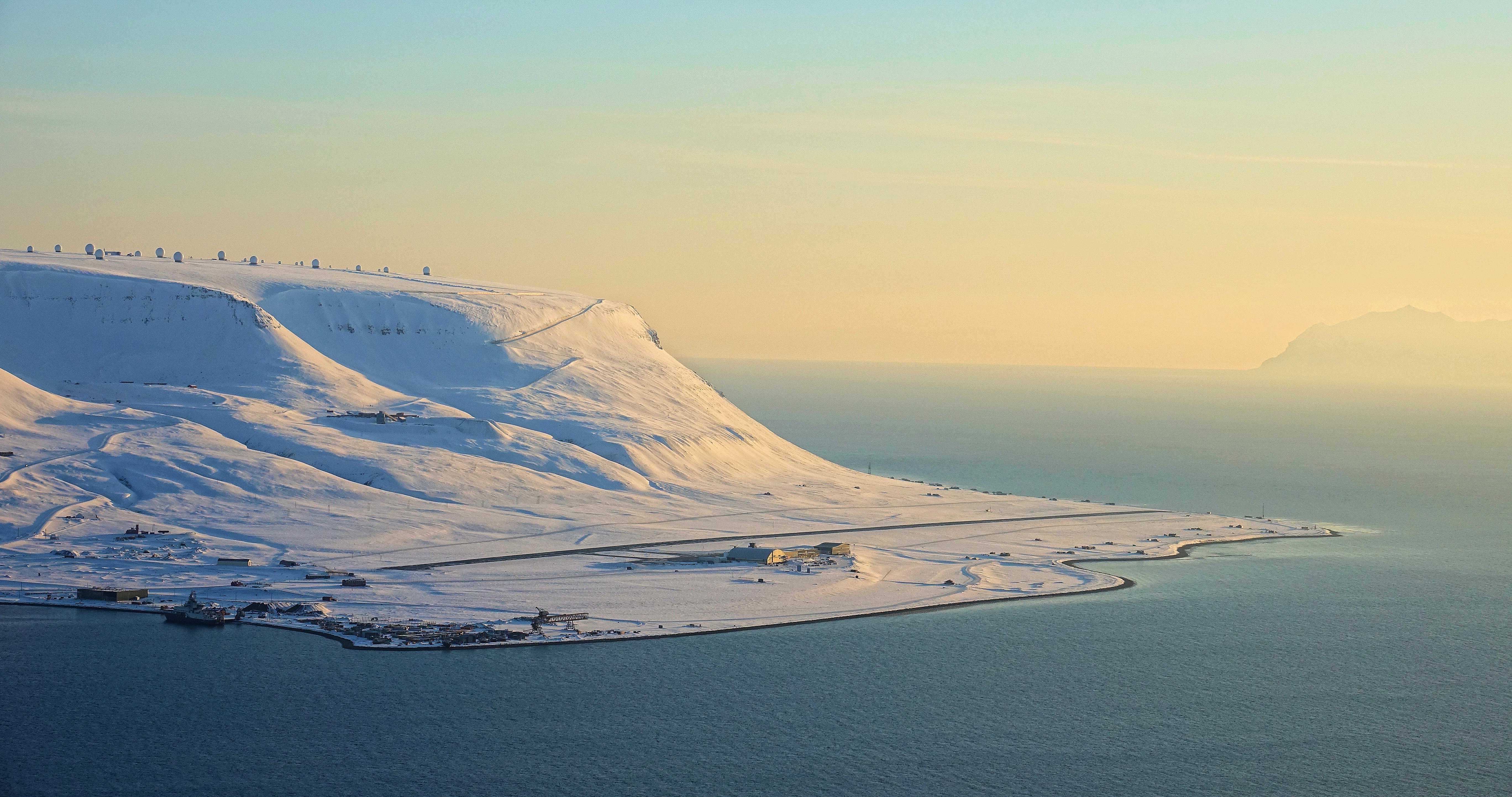
Hotellneset ("Hotel Point") is a peninsula north-west of Longyearbyen in Svalbard, Norway, sticking out into Adventfjorden. It is the location of Svalbard Airport, Longyear and the port for shipping of coal from Longyearbyen. Above Hotellneset is Platåberget, which is the location for Svalbard Satellite Station Svalbard Satellite Station ( no, Svalbard satellittstasjon) or SvalSat is a satellite ground station located on Platåberget near Longyearbyen in Svalbard, Norway. Opened in 1997, it is operated by Kongsberg Satellite Services (KSAT), a joint .... References Longyearbyen Peninsulas of Spitsbergen {{Spitsbergen-geo-stub ... [...More Info...] [...Related Items...] OR: [Wikipedia] [Google] [Baidu] |
Longyearbyen
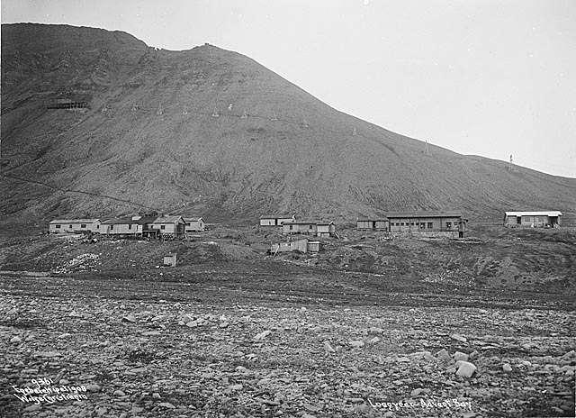
Longyearbyen (, locally �lɔ̀ŋjɑrˌbyːən "The Longyear Town") is the world's northernmost settlement with a population greater than 1,000 and the largest inhabited area of Svalbard, Norway. It stretches along the foot of the left bank of the Longyear Valley and on the shore of Adventfjorden, the short estuary leading into Isfjorden on the west coast of Spitsbergen, the island's broadest inlet. As of 2002 Longyearbyen Community Council became an official Norwegian municipality. It is the seat of the Governor of Svalbard. The town's mayor is Arild Olsen. Known as Longyear City until 1926, the town was established by and named after American John Munro Longyear, whose Arctic Coal Company started coal-mining there in 1906. Store Norske Spitsbergen Kulkompani (SNSK) took over the mining operations in 1916, and still conducts mining. The German ''Kriegsmarine'' almost completely destroyed the town on 8 September 1943, but rebuilding took place after the Second World Wa ... [...More Info...] [...Related Items...] OR: [Wikipedia] [Google] [Baidu] |
Svalbard Airport, Longyear
Svalbard Airport ( no, Svalbard lufthavn; ) is the main airport serving Svalbard in Norway. It is northwest of Longyearbyen on the west coast, and is the northernmost airport in the world with scheduled public flights. The first airport near Longyearbyen was constructed during World War II. In 1959, it was first used for occasional flights, but could only be used a few months a year. Construction of the new airport at Hotellneset started in 1973, and the airport was opened on 2 September 1975. It is owned and operated by state-owned Avinor. In 2014, the airport handled 154,261 passengers. Scandinavian Airlines operates daily flights to Tromsø and Oslo in mainland Norway. Lufttransport provides services to the two other airports on Svalbard: Ny-Ålesund and Svea, using Dornier 228 turboprop aircraft. There are also regular charter flights. History Adventdalen The first airstrip on Svalbard was constructed in Adventdalen, near Longyearbyen, by the Luftwaffe during World War II. ... [...More Info...] [...Related Items...] OR: [Wikipedia] [Google] [Baidu] |
Svalbard
Svalbard ( , ), also known as Spitsbergen, or Spitzbergen, is a Norwegian archipelago in the Arctic Ocean. North of mainland Europe, it is about midway between the northern coast of Norway and the North Pole. The islands of the group range from 74° to 81° north latitude, and from 10° to 35° east longitude. The largest island is Spitsbergen, followed by Nordaustlandet and . The largest settlement is Longyearbyen. The islands were first used as a base by the whalers who sailed far north in the 17th and 18th centuries, after which they were abandoned. Coal mining started at the beginning of the 20th century, and several permanent communities were established. The Svalbard Treaty of 1920 recognizes Norwegian sovereignty, and the 1925 Svalbard Act made Svalbard a full part of the Kingdom of Norway. They also established Svalbard as a free economic zone and a demilitarized zone. The Norwegian Store Norske and the Russian remain the only mining companies in place. Res ... [...More Info...] [...Related Items...] OR: [Wikipedia] [Google] [Baidu] |
Platåberget
Platåberget is a mountain in Nordenskiöld Land on the island of Spitsbergen in Svalbard, Norway. It is tall and has a distinct plateau shape, for which it is named. It is bordered to the west by Bjørndalen, to the east by Blomsterdalen and to the north by Hotellneset and Adventfjorden. The mountain is a few kilometers from Longyearbyen and is next to Svalbard Airport, Longyear. It is the site of Svalbard Satellite Station and Svalbard Global Seed Vault. On 30 April 1995, a 22-year-old Norwegian college student Nina Olaussen was killed by a polar bear The polar bear (''Ursus maritimus'') is a hypercarnivorous bear whose native range lies largely within the Arctic Circle, encompassing the Arctic Ocean, its surrounding seas and surrounding land masses. It is the largest extant bear specie ... on Platåberget, only a few kilometers from Longyearbyen. [...More Info...] [...Related Items...] OR: [Wikipedia] [Google] [Baidu] |
Peninsula
A peninsula (; ) is a landform that extends from a mainland and is surrounded by water on most, but not all of its borders. A peninsula is also sometimes defined as a piece of land bordered by water on three of its sides. Peninsulas exist on all continents. The size of a peninsula can range from tiny to very large. The largest peninsula in the world is the Arabian Peninsula. Peninsulas form due to a variety of causes. Etymology Peninsula derives , which is translated as 'peninsula'. itself was derived , or together, 'almost an island'. The word entered English in the 16th century. Definitions A peninsula is usually defined as a piece of land surrounded on most, but not all sides, but is sometimes instead defined as a piece of land bordered by water on three of its sides. A peninsula may be bordered by more than one body of water, and the body of water does not have to be an ocean or a sea. A piece of land on a very tight river bend or one between two rivers is sometimes s ... [...More Info...] [...Related Items...] OR: [Wikipedia] [Google] [Baidu] |
Norway
Norway, officially the Kingdom of Norway, is a Nordic country in Northern Europe, the mainland territory of which comprises the western and northernmost portion of the Scandinavian Peninsula. The remote Arctic island of Jan Mayen and the archipelago of Svalbard also form part of Norway. Bouvet Island, located in the Subantarctic, is a dependency of Norway; it also lays claims to the Antarctic territories of Peter I Island and Queen Maud Land. The capital and largest city in Norway is Oslo. Norway has a total area of and had a population of 5,425,270 in January 2022. The country shares a long eastern border with Sweden at a length of . It is bordered by Finland and Russia to the northeast and the Skagerrak strait to the south, on the other side of which are Denmark and the United Kingdom. Norway has an extensive coastline, facing the North Atlantic Ocean and the Barents Sea. The maritime influence dominates Norway's climate, with mild lowland temperatures on the se ... [...More Info...] [...Related Items...] OR: [Wikipedia] [Google] [Baidu] |
Adventfjorden
Adventfjorden (Advent Bay) is a 7 km long and 4 km wide bay running south-eastwards from the southern side of Isfjorden, on the west coast of Spitsbergen in Svalbard. The name represents a corruption of ''Adventure Bay'' - probably named after the Hull-built whaleship ''Adventure'', which operated in Isfjorden in 1656. The fjord was originally known as ''Klass Billen Bay''. At the head of Adventfjorden is Adventdalen (Advent Valley). The former mining-camp of Longyearbyen (now Svalbard's main town) lies on the fjord's southwestern shore, while another former mining-camp, Hiorthhamn, is located on its northeastern shore. References *Conway, W. M. 1906. No Man's Land: A History of Spitsbergen from Its Discovery in 1596 to the Beginning of the Scientific Exploration of the Country. Cambridge: At the University Press. * Norwegian Polar Institute The Norwegian Polar Institute (NPI; no, Norsk Polarinstitutt) is Norway's central governmental institution for scientific res ... [...More Info...] [...Related Items...] OR: [Wikipedia] [Google] [Baidu] |
Norwegian Polar Institute
The Norwegian Polar Institute (NPI; no, Norsk Polarinstitutt) is Norway's central governmental institution for scientific research, mapping and environmental monitoring in the Arctic and the Antarctic. The NPI is a directorate under Norway's Ministry of Climate and Environment. The institute advises Norwegian authorities on matters concerning polar environmental management and is the official environmental management body for Norwegian activities in Antarctica. Activities The institute's activities are focused on environmental research and management in the polar regions. The NPI's researchers investigate biodiversity, climate and environmental toxins in the Arctic and Antarctic, and in this context the institute equips and organizes large-scale expeditions to both polar regions. The institute contributes to national and international climate work, and is an active contact point for the international scientific community. The institute collects and analyses data on the environm ... [...More Info...] [...Related Items...] OR: [Wikipedia] [Google] [Baidu] |
Svalbard Satellite Station
Svalbard Satellite Station ( no, Svalbard satellittstasjon) or SvalSat is a satellite ground station located on Platåberget near Longyearbyen in Svalbard, Norway. Opened in 1997, it is operated by Kongsberg Satellite Services (KSAT), a joint venture between Kongsberg Defence & Aerospace and the Norwegian Space Centre (NSC). SvalSat and KSAT's Troll Satellite Station (TrollSat) in Antarctica are the only ground stations that can see a low altitude polar orbiting satellite (e.g., in sun-synchronous orbit) on every revolution as the earth rotates. As of December 2019 the facility consists of almost 100 multi-mission and customer-dedicated antennas which operate in the C, L, S, X and K bands. The station provides ground services to more satellites than any other facility in the world. Customers with their own installations include the European Organisation for the Exploitation of Meteorological Satellites (EUMETSAT), the National Aeronautics and Space Administration (NASA), ... [...More Info...] [...Related Items...] OR: [Wikipedia] [Google] [Baidu] |


