|
Horomatangi Reef
The Horomatangi Reef or reefs is a feature of Lake Taupō, in the central North Island of New Zealand. The reef is named after Horomātangi (Horo-matangi), the tāniwha or water monster of the lake, who is said to reside in a cave adjacent to the nearby Motutaiko Island to the south. The name Horomatangi Reefs perhaps better reflects its complex inner and outer structure with the shallow reefs separated by very deep areas, so tends to be used in the geological literature, while the term reef tends to be used geographically. Geology The reefs are at a high heat-output geothermal hot spot area within the Taupō Volcano. This is related to rhyolitic lava domes extruded after explosive volcanism including the VEI 7 Hatepe eruption of 232 ± 10 CE that ejected over of material (also known as Horomatangi Reef Unit Y eruption) and its linear line of eruption centres, as well as its own namesake Horomatangi, Unit S VEI 6 eruption of about 1460 BCE. Accordingly th ... [...More Info...] [...Related Items...] OR: [Wikipedia] [Google] [Baidu] |
Hatepe Eruption
The Hatepe eruption, named for the Hatepe Plinian pumice tephra layer, sometimes referred to as the Taupō eruption or Horomatangi Reef Unit Y eruption, is dated to 232 CE ± 10 and was Taupō Volcano's most recent major eruption. It is thought to be New Zealand's largest eruption within the last 20,000 years. The eruption ejected some of material, of which just over was ejected in a few minutes. This makes it one of the largest eruptions in the last 5,000 years, comparable to the Minoan eruption in the 2nd millennium BCE, the 946 eruption of Paektu Mountain, the 1257 eruption of Mount Samalas, and the 1815 eruption of Mount Tambora. Stages of the eruption The eruption went through several stages, with six distinct marker horizons identified. Despite the uniform composition of the erupted magma, a wide variety of eruptive styles were displayed, including weak phreatomagmatism, Plinian eruptions, and a huge pyroclastic flow. Rhyolitic lava domes were extruded some ye ... [...More Info...] [...Related Items...] OR: [Wikipedia] [Google] [Baidu] |
Lake Taupō
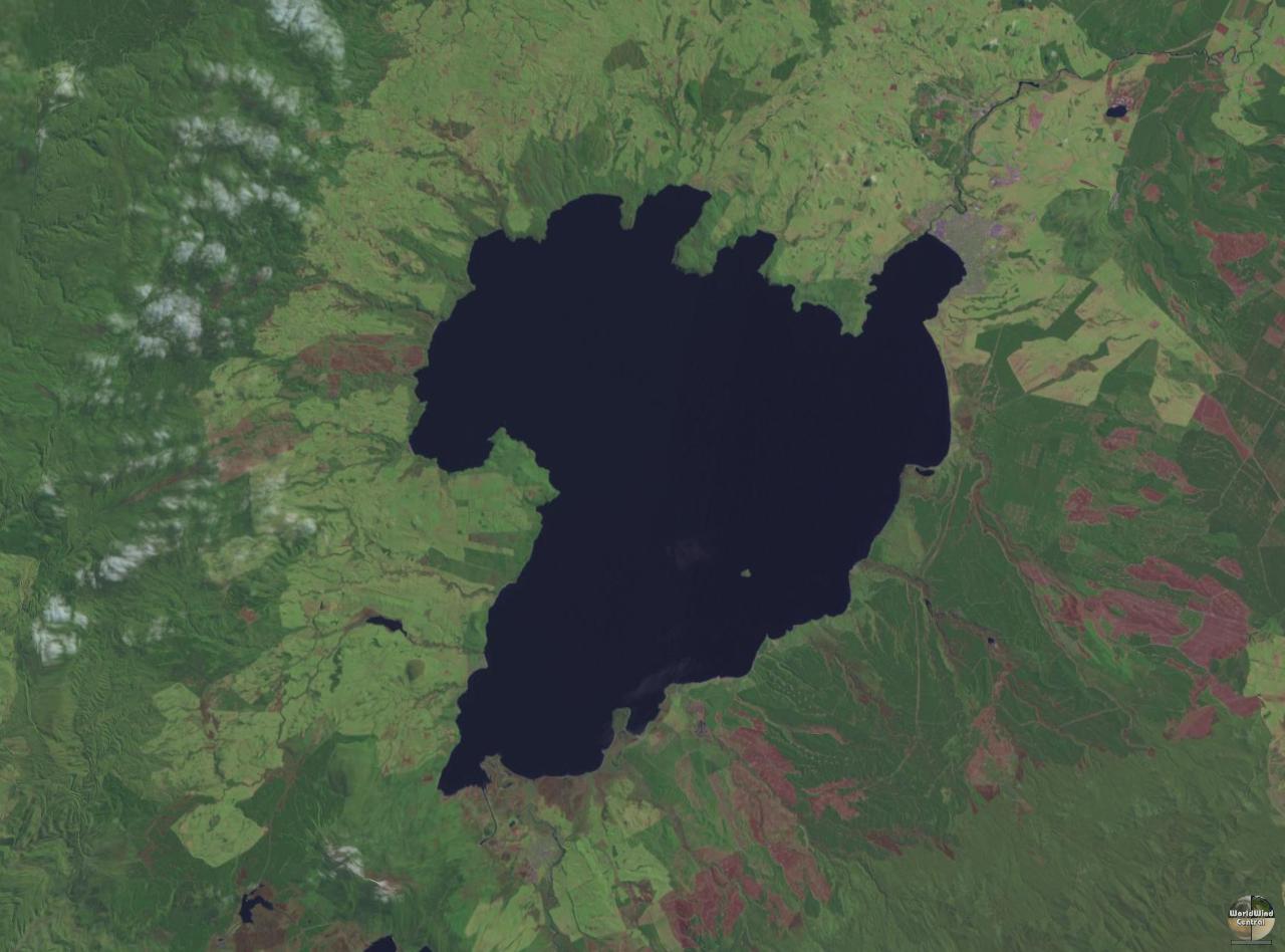
Lake Taupō (also spelled Taupo; mi, Taupō-nui-a-Tia or ) is a large crater lake in New Zealand's North Island, located in the caldera of the Taupō Volcano. The lake is the namesake of the town of Taupō, which sits on a bay in the lake's northeastern shore. With a surface area of , it is the largest lake by surface area in New Zealand, and the second largest freshwater lake by surface area in geopolitical Oceania after Lake Murray in Papua New Guinea. Motutaiko Island lies in the southeastern area of the lake. Lake Taupō has a perimeter of approximately and a maximum depth of . It is drained by the Waikato River (New Zealand's longest river), and its main tributaries are the Waitahanui River, the Tongariro River, and the Tauranga Taupō River. It is a noted trout fishery with stocks of introduced brown and rainbow trout. The level of the lake is controlled by Mercury Energy, the owner of the eight hydroelectric dams on the Waikato River downstream of Lake Taupō, usin ... [...More Info...] [...Related Items...] OR: [Wikipedia] [Google] [Baidu] |
Phreatomagmatic Eruption
Phreatomagmatic eruptions are volcanic eruptions resulting from interaction between magma and water. They differ from exclusively magmatic eruptions and phreatic eruptions. Unlike phreatic eruptions, the products of phreatomagmatic eruptions contain juvenile (magmatic) clasts.Heiken, G. & Wohletz, K. 1985. Volcanic Ash. University of California Press, Berkeley It is common for a large explosive eruption to have magmatic and phreatomagmatic components. Mechanisms Several competing theories exist as to the exact mechanism of ash formation. The most common is the theory of explosive thermal contraction of particles under rapid cooling from contact with water. In many cases the water is supplied by the sea, for example with Surtsey. In other cases the water may be present in a lake or caldera-lake, for example Santorini, where the phreatomagmatic component of the Minoan eruption was a result of both a lake and later the sea. There have also been examples of interaction between magma a ... [...More Info...] [...Related Items...] OR: [Wikipedia] [Google] [Baidu] |
North Island
The North Island, also officially named Te Ika-a-Māui, is one of the two main islands of New Zealand, separated from the larger but much less populous South Island by the Cook Strait. The island's area is , making it the world's 14th-largest island. The world's 28th-most-populous island, Te Ika-a-Māui has a population of accounting for approximately % of the total residents of New Zealand. Twelve main urban areas (half of them officially cities) are in the North Island. From north to south, they are Whangārei, Auckland, Hamilton, Tauranga, Rotorua, Gisborne, New Plymouth, Napier, Hastings, Whanganui, Palmerston North, and New Zealand's capital city Wellington, which is located at the south-west tip of the island. Naming and usage Although the island has been known as the North Island for many years, in 2009 the New Zealand Geographic Board found that, along with the South Island, the North Island had no official name. After a public consultation, the board officially ... [...More Info...] [...Related Items...] OR: [Wikipedia] [Google] [Baidu] |
New Zealand
New Zealand ( mi, Aotearoa ) is an island country in the southwestern Pacific Ocean. It consists of two main landmasses—the North Island () and the South Island ()—and over 700 smaller islands. It is the sixth-largest island country by area, covering . New Zealand is about east of Australia across the Tasman Sea and south of the islands of New Caledonia, Fiji, and Tonga. The country's varied topography and sharp mountain peaks, including the Southern Alps, owe much to tectonic uplift and volcanic eruptions. New Zealand's capital city is Wellington, and its most populous city is Auckland. The islands of New Zealand were the last large habitable land to be settled by humans. Between about 1280 and 1350, Polynesians began to settle in the islands and then developed a distinctive Māori culture. In 1642, the Dutch explorer Abel Tasman became the first European to sight and record New Zealand. In 1840, representatives of the United Kingdom and Māori chiefs ... [...More Info...] [...Related Items...] OR: [Wikipedia] [Google] [Baidu] |
Taniwha
In Māori mythology, taniwha () are large supernatural beings that live in deep pools in rivers, dark caves, or in the sea, especially in places with dangerous currents or deceptive breakers (giant waves). They may be considered highly respected kaitiaki (protective guardians) of people and places, or in some traditions as dangerous, predatory beings, which for example would kidnap women to have as wives. Etymology and Pacific analogues Linguists have reconstructed the word ''taniwha'' to Proto-Oceanic *''tanifa'', with the meaning "shark species". In Tongan and Niuean, ''tenifa'' refers to a large dangerous shark, as does the Samoan ''tanifa''; the Tokelauan ''tanifa'' is a sea-monster that eats people. In most other Polynesian languages, the cognate words refer to sharks or simply fish. Some anthropologists have stated that the taniwha has "analogues that appear within other Polynesian cosmologies".A. Asbjørn Jøn,The Road and the Taniwha in ''Australian Folklore: A Yearly ... [...More Info...] [...Related Items...] OR: [Wikipedia] [Google] [Baidu] |
Motutaiko Island
Motuaiko Island is the only island within Lake Taupō on the North Island of New Zealand. It sits near the town of Motutere. The name "Motutaiko" is from the Māori language, with "motu" meaning island, and "taiko" being a name for the black petrel ('' Procellaria parkinsoni''). Natural features Geology Motutaiko Island is formed out of a column of rhyolitic lava, connected to the geologic systems of the Taupō Volcano. The island was likely formed after an underwater magma vent's releases cooled and hardened into a cone, with Motutaiko forming the apex at above sea level. There has recently been little volcanic seismicity directly under Motutaiko Island compared to adjacent areas of Lake Taupo. Biology Several endangered species live on the island, including '' Wainuia clarki''. Other animals present on the island include a colony of cormorants and the small-scaled skink. The type specimen for this small skink was captured there in 1971 before being found elsewhere in the cen ... [...More Info...] [...Related Items...] OR: [Wikipedia] [Google] [Baidu] |
Taupō Volcano
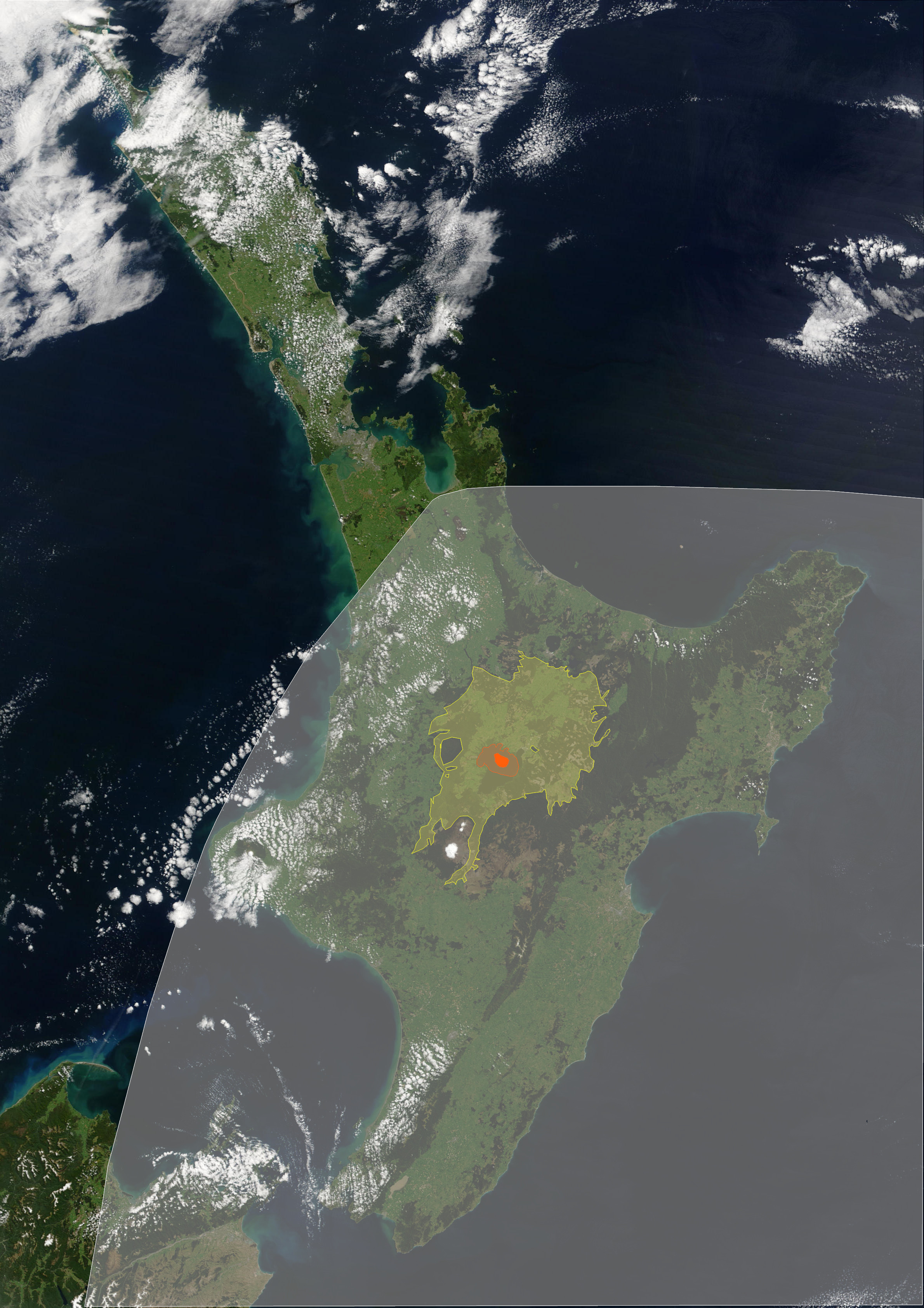
Lake Taupō, in the centre of New Zealand's North Island, is the caldera of the Taupō Volcano, a large rhyolitic supervolcano. This huge volcano has produced two of the world's most violent eruptions in geologically recent times. ImageSize = width:320 height:800 PlotArea = right:50 top:10 left:50 bottom:10 DateFormat = yyyy TimeAxis = orientation:vertical order:reverse Period = from:-10000 till:2050 AlignBars = early ScaleMajor = unit:year increment:1000 start:-10000 Colors = id:canvas value:rgb(1,1,0.85) BackgroundColors = canvas:canvas PlotData = width:15 color:white bar:test from:-10000 till:1200 # Pre Maori PlotData = width:15 color:yellow bar:test from:1200 till:1840 # Pre accurate PlotData = width:15 color:orange bar:test from:1840 till:2050 # Accurate PlotData = at:-9999 shift:(30,0) text: Recent eruptions of Taupō caldera at:-9999 shift:(200,0) textcolor:red text: Eruptive at:-9850 shift:(80,-1) textcolor:red fontsize:S text:(Er ... [...More Info...] [...Related Items...] OR: [Wikipedia] [Google] [Baidu] |
Rhyolite
Rhyolite ( ) is the most silica-rich of volcanic rocks. It is generally glassy or fine-grained (aphanitic) in texture, but may be porphyritic, containing larger mineral crystals (phenocrysts) in an otherwise fine-grained groundmass. The mineral assemblage is predominantly quartz, sanidine, and plagioclase. It is the extrusive equivalent to granite. Rhyolitic magma is extremely viscous, due to its high silica content. This favors explosive eruptions over effusive eruptions, so this type of magma is more often erupted as pyroclastic rock than as lava flows. Rhyolitic ash-flow tuffs are among the most voluminous of continental igneous rock formations. Rhyolitic tuff has been extensively used for construction. Obsidian, which is rhyolitic volcanic glass, has been used for tools from prehistoric times to the present day because it can be shaped to an extremely sharp edge. Rhyolitic pumice finds use as an abrasive, in concrete, and as a soil amendment. Description Rhyolite i ... [...More Info...] [...Related Items...] OR: [Wikipedia] [Google] [Baidu] |
Complex Volcano
A complex volcano, also called a compound volcano or a volcanic complex, is a mixed landform consisting of related volcanic centers and their associated lava flows and pyroclastic rock. They may form due to changes in eruptive habit or in the location of the principal vent area on a particular volcano. Stratovolcanoes can also form a large caldera that gets filled in by a lava dome, or else multiple small cinder cones, lava domes and craters may develop on the caldera's rim. Although a comparatively unusual type of volcano, they are widespread in the world and in geologic history. Metamorphosed ash flow tuffs are widespread in the Precambrian rocks of northern New Mexico, which indicates that caldera complexes have been important for much of Earth's history. Yellowstone National Park is on three partly covered caldera complexes. The Long Valley Caldera in eastern California is also a complex volcano; the San Juan Mountains in southwestern Colorado are formed on a group of N ... [...More Info...] [...Related Items...] OR: [Wikipedia] [Google] [Baidu] |
Taupō Volcanic Zone
The Taupō Volcanic Zone (TVZ) is a volcanic area in the North Island of New Zealand that has been active for the past two million years and is still highly active. Mount Ruapehu marks its south-western end and the zone runs north-eastward through the Taupō and Rotorua areas and offshore into the Bay of Plenty. It is part of the larger Central Volcanic Region that extends further westward through the western Bay of Plenty to the eastern side of the Coromandel Peninsula and has been active for four million years. At Taupō the rift volcanic zone is widening east–west at the rate of about 8 mm per year while at Mount Ruapehu it is only 2–4 mm per year but this increases at the north eastern end at the Bay of Plenty coast to 10–15 mm per year. It is named after Lake Taupō, the flooded caldera of the largest volcano in the zone, the Taupō Volcano and contains a large central volcanic plateau as well as other landforms associated with its containing tectonic i ... [...More Info...] [...Related Items...] OR: [Wikipedia] [Google] [Baidu] |


