|
Holmeswood
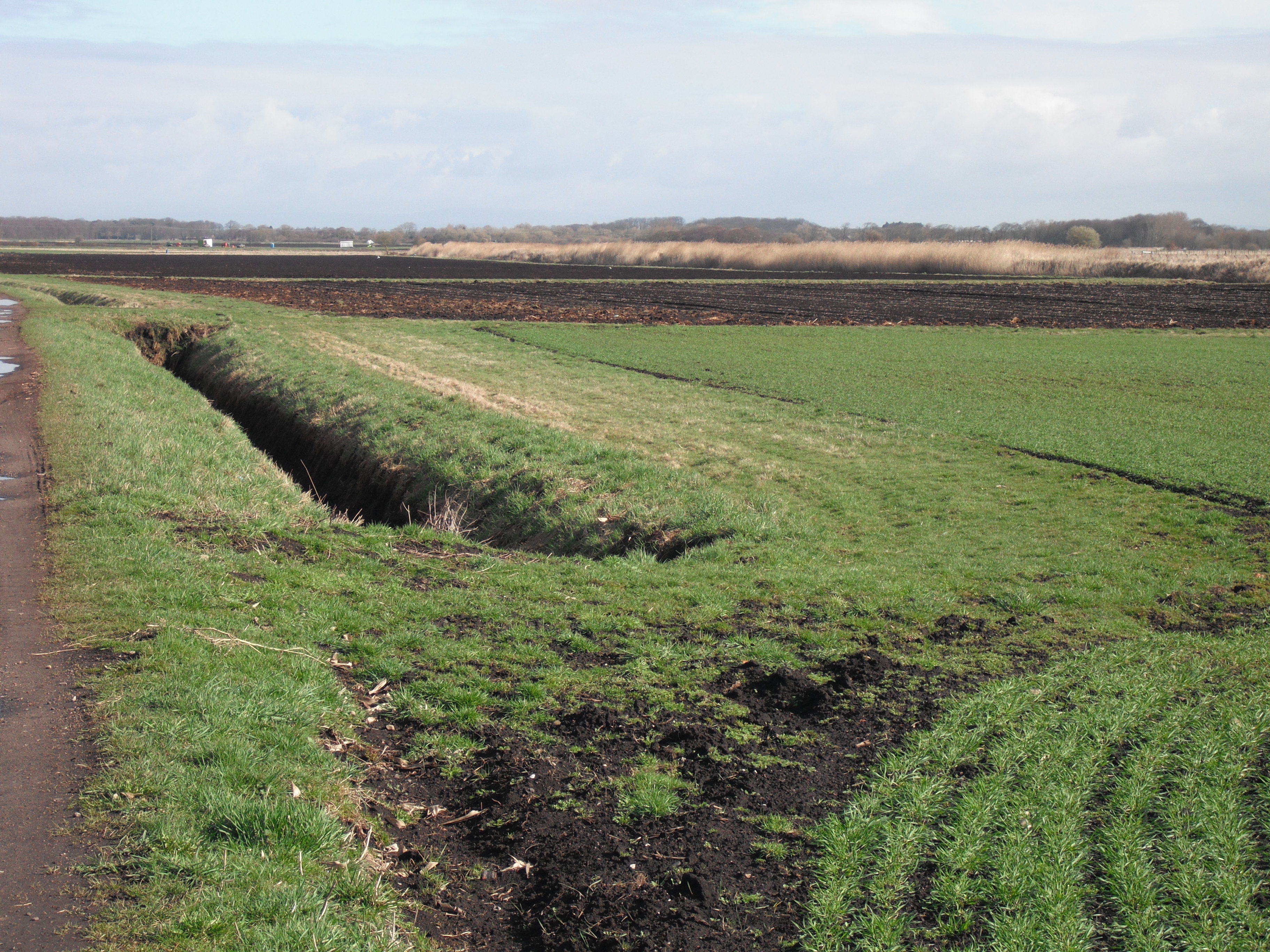
Holmeswood is a small agricultural village in West Lancashire, in the north-west of England. It lies just north of the Martin Mere Wetland Centre and to the south of North Meols about six miles east of the Irish Sea coast at Southport. The village's position on the West Lancashire Coastal Plain lends it very fertile soil; unsurprisingly, agriculture (primarily of vegetables, though also some grain) is the economic mainstay of the village. Some smaller-scale pastoral farming is also seen, too. In contrast to the more northerly villages around Banks, Holmeswood has remained largely undeveloped, although it is conveniently placed for commuting to the nearby towns of Southport, Preston, Burscough and Ormskirk. For local matters, the village falls under Rufford Parish Council. The village lies almost wholly on the B5246, which runs from Mere Brow to Rufford. As befits an agricultural village of its size, Holmeswood has a small village hall (now home to the village nursery s ... [...More Info...] [...Related Items...] OR: [Wikipedia] [Google] [Baidu] |
Rufford, Lancashire
Rufford is a village in West Lancashire, England, where the Leeds and Liverpool Canal, Liverpool, Ormskirk and Preston Railway, the A59 road, A59 and the River Douglas, Lancashire, River Douglas meet. Rufford is also a civil parish, which includes the neighbouring village of Holmeswood, and in 2011 had a population of 2,049. History Rufford's name derives from the Old English ''rūh'' and ''ford'', the rough Ford (crossing), ford. It was a crossing place over the River Douglas. Rufford was recorded as Ruchford in 1212, Rufford in 1285, Roughford in 1318, Rughford in 1332 and Roghforth in 1411. Part of the manor was granted by Richard Bussel, baron of Penwortham to Richard Fitton in the reign of Henry I of England, Henry I. In 1278 his descendant and heiress Dame Maude Fitton married Sir William Hesketh. Sir William's grandson married the daughter of Edmund Fitton, who owned the other moiety title, moiety of the manor which then descended with the Heskeths. In 1339 Sir William ... [...More Info...] [...Related Items...] OR: [Wikipedia] [Google] [Baidu] |
Martin Mere
Martin Mere is a Mere (lake), mere near Burscough, in Lancashire, England, on the West Lancashire Coastal Plain. The mere is a vast marsh, around that was, until it was drained, the largest body of fresh water in England. History Martin Mere was formed at the end of the Last Glacial Period, last ice age, when water filled a depression in the Glacial Drift, glacial drift. Since then its size has varied as water levels have risen and fallen. The original giant lake can be seen on Christopher Saxton's map from 1579 and stretched from Rufford, Lancashire, Rufford in the east, to Churchtown, Merseyside, Churchtown (then known as North Meols) in the west. To the north of the lake were the villages of Mere Brow and Holmeswood, the site of Holmeswood Hall, built by the Heskeths as a hunting lodge. South of the lake was the Scarisbrick Hall estate, Martin Hall and Tarlefarwood, now known as Tarlscough. The mere originally drained out in two places; at the western end the arm of the me ... [...More Info...] [...Related Items...] OR: [Wikipedia] [Google] [Baidu] |
Holmes, Lancashire
Holmes is a hamlet in West Lancashire, England. It is adjacent to the larger village of Mere Brow, which is between the much larger villages of Banks to the west and Tarleton to the east. It is directly situated on the A565 road, which gives the village good links with Preston, Southport and Liverpool. Historically, the village was an agricultural settlement, due to the excellent soil, and farming is still important. The hamlet is administered by West Lancashire District Council and Tarleton parish council. Holmes and neighbouring Mere Brow were part of the ancient parish of North Meols North Meols is a civil parish and electoral ward in the West Lancashire district of Lancashire, England. The parish covers the village of Banks and the hamlet of Hundred End. The population of the parish/ward at the 2011 census was 4,146. Hi ... but now are part of Tarleton parish. Holmes has a small church. The main business is Huntapac, a farming company that grows and supplies vegeta ... [...More Info...] [...Related Items...] OR: [Wikipedia] [Google] [Baidu] |
Sollom
Sollom is a hamlet in the parish of Tarleton, in Lancashire, England. It lies south of Tarleton and north of Rufford on the A59 road, giving the village good links to Preston, Southport and Liverpool. Historically, the village was primarily an agricultural village thanks to the excellent soil, and farms in the area are still in use today. Governance The village is administered by West Lancashire District Council and Tarleton parish council. Transport The A59 road meets with the A565 road at a cross road junction with traffic lights on the border of Sollom and Tarleton. The A59 is the main road that runs through the hamlet. The nearest railway station is at Rufford, which is on the Preston-Ormskirk Branch service. The Rufford branch of the Leeds and Liverpool Canal The Leeds and Liverpool Canal is a canal in Northern England, linking the cities of Leeds and Liverpool. Over a distance of , crossing the Pennines, and including 91 locks on the main line. The Leeds and Live ... [...More Info...] [...Related Items...] OR: [Wikipedia] [Google] [Baidu] |
Scarisbrick
Scarisbrick () is a village and civil parish in West Lancashire, England. The A570, the main road between Ormskirk and Southport, runs through Scarisbrick, and much of the village lies along it. As a result, it does not have a traditional village centre, though the junction with the A5147 is close to the geographic centre. Toponymy Scarisbrick literally means "Skar's slope" and comes from the Old Norse ''Skar'' (a personal name) + ''-es'' ( possessive) + ''brekka'' ("slope"). It is thought that the personal name is Danish, though the second element suggests Norwegian settlement. The "slope" may refer to a slight incline between two streams near the site of Scarisbrick Hall. The name was recorded as ''Scharisbrec'' c.1200, ''Skaresbrek'' in 1238, and finally ''Scarisbrick'' c.1240. History In its early history, travellers tended to avoid Scarisbrick parish. Martin Mere, a large lake with associated marshlands and peat bogs, made the immediate area quite difficult to cross. Mu ... [...More Info...] [...Related Items...] OR: [Wikipedia] [Google] [Baidu] |
Southport
Southport is a seaside town in the Metropolitan Borough of Sefton in Merseyside, England. At the 2001 census, it had a population of 90,336, making it the eleventh most populous settlement in North West England. Southport lies on the Irish Sea coast and is fringed to the north by the Ribble estuary. The town is north of Liverpool and southwest of Preston. Within the boundaries of the historic county of Lancashire, the town was founded in 1792 when William Sutton, an innkeeper from Churchtown, built a bathing house at what is now the south end of Lord Street.''North Meols and Southport – a History'', Chapter 9, Peter Aughton (1988) At that time, the area, known as South Hawes, was sparsely populated and dominated by sand dunes. At the turn of the 19th century, the area became popular with tourists due to the easy access from the nearby Leeds and Liverpool Canal. The rapid growth of Southport largely coincided with the Industrial Revolution and the Victorian er ... [...More Info...] [...Related Items...] OR: [Wikipedia] [Google] [Baidu] |
West Lancashire Coastal Plain
The West Lancashire Coastal Plain is a large area in the south west of Lancashire, England. The plain stretches from the Rimrose Valley in Seaforth, near Liverpool on the Mersey, to the south, to Preston on the Ribble, to the north. To the east, the plain is bounded by the foothills of the Pennines, while the western edge of the plain is separated from the sea by sand dunes. It is very flat, and much of it is only a few metres above sea level. The terrain is mostly glacial in origin. The area has been inhabited since Neolithic times, though large areas would have been marshy and contained Martin Mere. The WWT Martin Mere near the villages of Holmeswood and Tarlscough gives a glimpse of what this area may have looked like prior to reclamation. The mere as it was before drainage of the area was the second largest body of fresh water in England, behind Windermere. The rivers Mersey, Alt and Ribble feed into the plain and the flood plains add to the flatness. Large areas have ... [...More Info...] [...Related Items...] OR: [Wikipedia] [Google] [Baidu] |
West Lancashire
West Lancashire is a local government district with borough status in Lancashire, England. The council is based in Ormskirk, and the largest town in the borough is Skelmersdale. At the 2011 Census, the population of the borough was 110,685. History The district was created on 1 April 1974 under the Local Government Act 1972, as a non-metropolitan district, with Lancashire County Council as the higher tier authority providing county-level services. West Lancashire covered the whole territory of two former districts and parts of another two districts, all of which were abolished at the same time: *Ormskirk Urban District *Skelmersdale and Holland Urban District *West Lancashire Rural District (majority of former district's territory; remainder went to Merseyside) *Wigan Rural District (parishes of Dalton, Parbold and Wrightington; remainder went to Greater Manchester) In 2009 the district was awarded borough status, causing the council to change its name from West Lancashir ... [...More Info...] [...Related Items...] OR: [Wikipedia] [Google] [Baidu] |
Mere Brow
Mere Brow is a small village in Lancashire, England, situated between Tarleton and Banks, just off the A565 road. It is 6 miles (9 km) east of Southport and 10 miles (15 km) south west of Preston. It is administered by the West Lancashire Borough Council and the Tarleton parish council. It is in the West Lancashire parliamentary constituency. Mere Brow is the second largest village in the parish of Tarleton, the largest being Tarleton and the smallest being Holmes and Sollom. History Mere Brow and the neighbouring village of Holmes were part of the ancient parish of North Meols but now are part of Tarleton parish. The name Mere Brow is believed to have come from the time when it was the most northerly settlement on Martin Mere. Economy Mere Brow was primarily an agricultural village due to the excellent soil, although there was fishing activity for many years. Production of flowers and vegetables is common on the farms around the village. The village has a public ho ... [...More Info...] [...Related Items...] OR: [Wikipedia] [Google] [Baidu] |
Rufford Old Hall
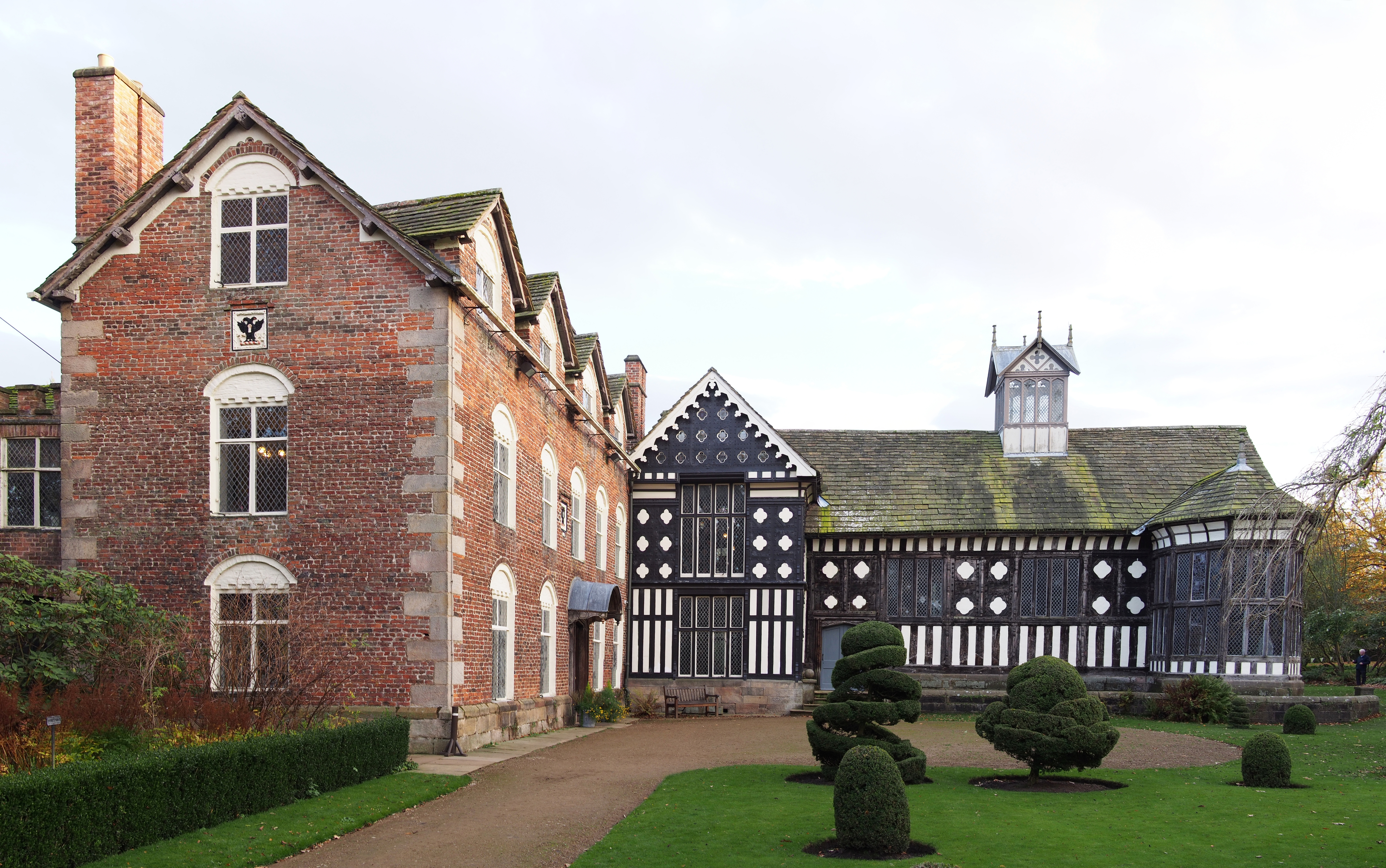
Rufford Old Hall is a National Trust property in Rufford, Lancashire, England. Built in about 1530 for Sir Robert Hesketh, only the Great Hall survives from the original structure. A brick-built wing in the Jacobean style was added in 1661, at right angles to the Great Hall, and a third wing was added in the 1820s. Rufford Old Hall is designated by English Heritage as a Grade I listed building, The hall's cottage, coach house and stables, about to the east, are designated Grade II. History Until 1936, Rufford Old Hall was in the continuous ownership of the Hesketh family who were lords of the manor of Rufford from the 15th century. The Heskeths moved to Rufford New Hall in 1798. In 1846 Sir Thomas George Hesketh, 5th Baronet married Lady Anna Maria Arabella Fermor, sister and heiress of George Richard William Fermor, 5th and last Earl of Pomfret. In 1936 Rufford Old Hall, with its collection of arms and armour and 17th-century oak furniture, was donated to the National Tr ... [...More Info...] [...Related Items...] OR: [Wikipedia] [Google] [Baidu] |
Hesketh Baronets
Hesketh may refer to: People * Baron Hesketh: the various barons or lords Hesketh, who lived at Easton Neston in Northamptonshire, England ** Lord Hesketh: the Conservative Party politician, formally titled Alexander Fermor-Hesketh, 3rd Baron Hesketh *** Hesketh Racing: the 1970s Formula One racing team, formed by Alexander Hesketh *** Hesketh Motorcycles: the motorcycle brand, formed by Alexander Hesketh * Chris Hesketh, English rugby league footballer * Kenneth Hesketh, British composer * Jake Hesketh, English association footballer * Karne Hesketh, New Zealand-born Japanese rugby player * Philip Hesketh, British Anglican priest and current Dean of Rochester * Sean Hesketh, English rugby league footballer * Thomas Hesketh, English politician * Victoria Hesketh, English musician better known by her stage name Little Boots Places * Hesketh, Alberta: a Canadian hamlet * Hesketh Bank: a small agricultural village in Lancashire Etymology The name came, as a placename, from Old Norse ' ... [...More Info...] [...Related Items...] OR: [Wikipedia] [Google] [Baidu] |
Lancashire Records Office
The Lancashire Archives, previously known as the Lancashire Record Office, is a county record office located in the city of Preston which serves Lancashire, England. It was established in 1940. Early history In 1808 the Lancashire Justices first took an interest in the records, ordering the Clerk of the Peace to "arrange the Public Records in his office in such a manner as to him shall appear to be the most proper, for their preservation and utility". In 1879, the Justices obtained an Act of Parliament allowing them to build offices for "county business". This included a room for keeping the county records. Sessions House was built in 1903 with rooms for documents in it.Article written by R. Sharpe France, 1952 for ARCHIVES, No.7, in the Lancashire Archives, LCC 968 In December 1937, the Preston and mid-Lancashire branch of the Historical Association sent a petition to Lancashire County Council, asking whether the council could "sanction and establish a depository for document ... [...More Info...] [...Related Items...] OR: [Wikipedia] [Google] [Baidu] |


