|
Holden (Martian Crater)
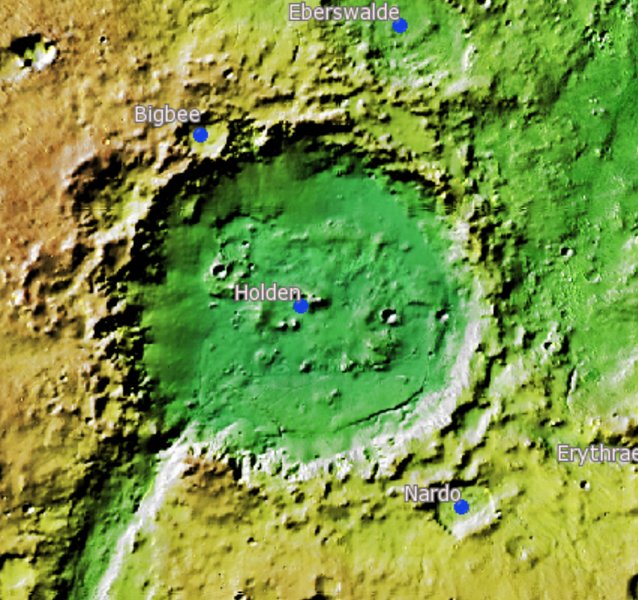
Holden is a 140 km wide crater situated within the Margaritifer Sinus quadrangle (MC-19) region of the planet Mars, located with the southern highlands. It is named after American astronomer Edward Singleton Holden. It is part of the Uzboi-Landon-Morava (ULM) system. Description Like Gusev, it is notable for an outlet channel, Uzboi Vallis, that runs into it, and for many features that seem to have been created by flowing water. It's believed that Holden crater was formed by an impact during the Noachian or Hesperian periods.Grant, J. et al. 2008. HiRISE imaging of impact megabreccia and sub-meter aqueous strata in Holden Crater, Mars. Geology: 36, 195-198. The crater's rim is cut with gullies, and at the end of some gullies are fan-shaped deposits of material transported by water. The crater is of great interest to scientists because it has some of the best-exposed lake deposits. One of the layers has been found by the '' Mars Reconnaissance Orbiter'' to cont ... [...More Info...] [...Related Items...] OR: [Wikipedia] [Google] [Baidu] |
Thermal Emission Imaging System
The Thermal Emission Imaging System (THEMIS) is a camera on board the 2001 Mars Odyssey orbiter. It images Mars in the visible and infrared parts of the electromagnetic spectrum in order to determine the thermal properties of the surface and to refine the distribution of minerals on the surface of Mars as determined by the Thermal Emission Spectrometer (TES). Additionally, it helps scientists to understand how the mineralogy of Mars relates to its landforms, and it can be used to search for thermal hotspots in the Martian subsurface. THEMIS is managed from the Mars Space Flight Facility at Arizona State University and was built by the Santa Barbara Remote Sensing division of Raytheon Technologies Corporation, an American multinational conglomerate headquartered in Waltham, Massachusetts. The instrument is named after Themis, the goddess of justice in ancient Greek mythology. Infrared camera THEMIS detects thermal infrared energy emitted by the Martian surface at nin ... [...More Info...] [...Related Items...] OR: [Wikipedia] [Google] [Baidu] |
Gale (crater)
Gale is a crater, and probable dry lake, at in the northwestern part of the Aeolis quadrangle on Mars. It is in diameter and estimated to be about 3.5–3.8 billion years old. The crater was named after Walter Frederick Gale, an amateur astronomer from Sydney, Australia, who observed Mars in the late 19th century. Aeolis Mons is a mountain in the center of Gale and rises high. Aeolis Palus is the plain between the northern wall of Gale and the northern foothills of Aeolis Mons. Peace Vallis, a nearby outflow channel, 'flows' down from the hills to the Aeolis Palus below and seems to have been carved by flowing water. Several lines of evidence suggest that a lake existed inside Gale shortly after the formation of the crater. The NASA Mars rover ''Curiosity'', of the Mars Science Laboratory (MSL) mission, landed in "Yellowknife" ''Quad 51'' of Aeolis Palus in Gale at 05:32 UTC August 6, 2012. NASA named the landing location Bradbury Landing on August 22, 2012. ''Curios ... [...More Info...] [...Related Items...] OR: [Wikipedia] [Google] [Baidu] |
List Of Craters On Mars
__NOTOC__ This is a list of craters on Mars. Impact craters on Mars larger than exist by the hundreds of thousands, but only about one thousand of them have names. Names are assigned by the International Astronomical Union after petitioning by relevant scientists, and in general, only craters that have a significant research interest are given names. Martian craters are named after famous scientists and science fiction authors, or if less than in diameter, after towns on Earth. Craters cannot be named for living people, and names for small craters are rarely intended to commemorate a specific town. Latitude and longitude are given as planetographic coordinates with west longitude. Catalog of named craters The catalog is divided into three partial lists: * List of craters on Mars: A–G * List of craters on Mars: H–N * List of craters on Mars: O–Z Names are grouped into tables for each letter of the alphabet, containing the crater's name (linked if article exists), co ... [...More Info...] [...Related Items...] OR: [Wikipedia] [Google] [Baidu] |
PSP 001666 1530 Holden
PSP may refer to: Organisations Politics *Pak Sarzameen Party, a defunct political party in Pakistan * Pacifist Socialist Party (Dutch: ''Pacifistisch Socialistische Partij''), a former Dutch political party *Partido Socialista Popular (Cuba) *People's Services Party, a political party in Vanuatu *Popular Socialist Party (Argentina) ( es, Partido Socialista Popular), a former political party in Argentina * Popular Socialist Party, a post World War II Socialist Party of Chile * Popular Socialist Party (Haiti) (french: Parti Socialiste Populaire), a former communist political party in Haiti *Popular Socialist Party (Mexico) ( es, Partido Popular Socialista, ''PPS''), a communist party in Mexico *Popular Socialist Party (Spain) ( es, Partido Socialista Popular), a former Spanish political party that has merged with the Spanish Socialist Workers' Party (PSOE) *Praja Socialist Party, a former Indian political party * Progress Singapore Party, a political party in Singapore *Progressive ... [...More Info...] [...Related Items...] OR: [Wikipedia] [Google] [Baidu] |
Meridiani Planum
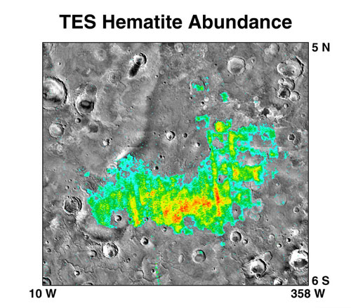
The Meridiani Planum (alternately Meridiani plain, Meridiani plains, Terra Meridiani, or Terra Meridiani plains) is either a large plain straddling the equator of Mars and covered with a vast number of spherules containing a lot of iron oxide or a region centered on this plain that includes some adjoining land. The plain sits on top of an enormous body of sediments that contains a lot of bound water. The iron oxide in the spherules is crystalline (grey) hematite (Fe203). The Meridiani Planum is one of the most thoroughly investigated regions of Mars. Many studies were carried out by the scientists involved with NASA's Mars Exploration Rover (MER) ''Opportunity''. Two outstanding features found by these investigations are the actions of water flow and aqueous chemistry in this plain's geological history and, particularly specific to the plain, an abundance and ubiquity of small spherules composed mainly of grey-hematite that sit loosely on top of the plain's soils and underneath ... [...More Info...] [...Related Items...] OR: [Wikipedia] [Google] [Baidu] |
Nili Fossae
Nili Fossae is a group of large, concentric grabens on Mars, in the Syrtis Major quadrangle. They have been eroded and partly filled in by sediments and clay-rich ejecta from a nearby giant impact crater, the Isidis basin. It is at approximately 22°N, 75°E, and has an elevation of . Nili Fossae was on the list of potential landing sites of the Mars Science Laboratory, arriving in 2012, but was dropped before the final four sites were determined. Although not among the last finalists, in September 2015 it was selected as a potential landing site for the Mars 2020 rover, which will use the same design as ''Curiosity'', but with a different payload focused on astrobiology. A large exposure of olivine is in Nili Fossae. In December 2008, NASA's Mars Reconnaissance Orbiter found that rocks at Nili Fossae contain carbonate minerals, a geologically significant discovery. Other minerals found by MRO are aluminum smectite, iron/magnesium smecite, hydrated silica, kaolinite group mi ... [...More Info...] [...Related Items...] OR: [Wikipedia] [Google] [Baidu] |
Miyamoto (crater)
Miyamoto is a crater within the Margaritifer Sinus quadrangle (MC-19) region of the planet Mars, west of the Plains of Meridiani. It is wide. Its northeastern half is filled with rocks formed in the presence of water and include minerals of iron and sulfur, which likely settled on lake bottoms or in groundwater systems. In the southwestern half of the crater floor, erosion has stripped these materials away, revealing clays and other materials like those found in the most ancient Martian rocks. More than 3.5 billion years old, they date to the Noachian era at which time, liquid water was likely present at the surface and could have created an environment favorable to life. Miyamoto was considered as a possible landing site for the Mars Science Laboratory. Mars Science Laboratory Several sites in the Margaritifer Sinus quadrangle have been proposed as areas to send NASA's next major Mars rover, the Mars Science Laboratory. Miyamoto Crater was in the top seven sites chosen. ... [...More Info...] [...Related Items...] OR: [Wikipedia] [Google] [Baidu] |
Mawrth Vallis
Mawrth Vallis () (Mawrth means "Mars" in Welsh) is a valley on Mars, located in the Oxia Palus quadrangle at 22.3°N, 343.5°E with an elevation approximately two kilometers below datum. Situated between the southern highlands and northern lowlands, the valley is a channel formed by massive flooding which occurred in Mars’ ancient past. It is an ancient water outflow channel with light-colored clay-rich rocks. Prior to the selection of Gale Crater for the Mars Science Laboratory (MSL) ''Curiosity'' rover mission, Mawrth Vallis was considered as a potential landing site because of the detection of a stratigraphic section rich in clay minerals. Clay minerals have implications for past aqueous environments as well as the potential to preserve biosignatures, making them ideal targets for the search for life on Mars. Although Mawrth Vallis was not chosen as a landing target, there is still interest in understanding the mineralogy and stratigraphy of the area. Until a rover missio ... [...More Info...] [...Related Items...] OR: [Wikipedia] [Google] [Baidu] |
Curiosity (rover)
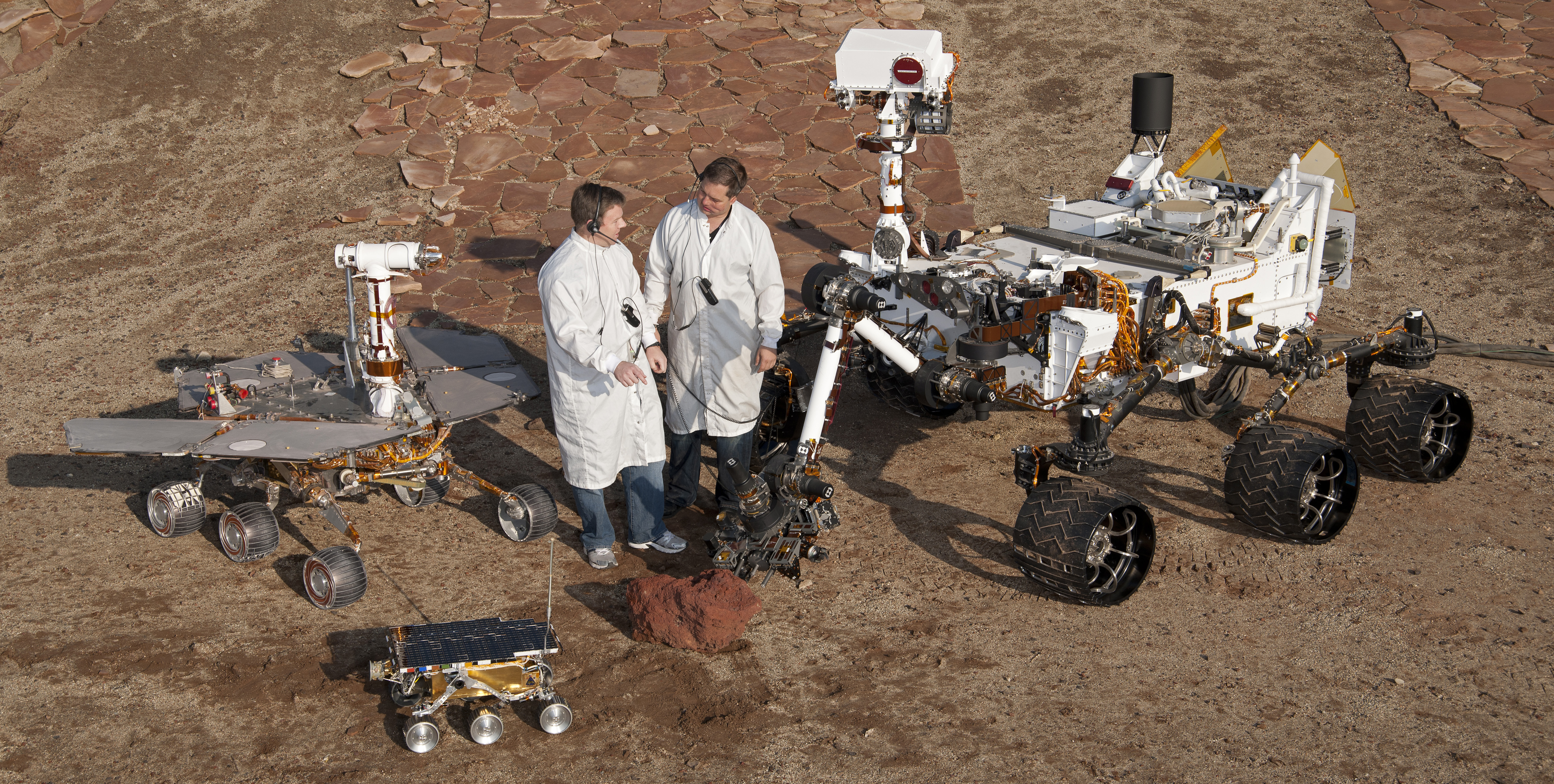
''Curiosity'' is a car-sized Mars rover designed to explore the Gale crater on Mars as part of NASA's Mars Science Laboratory (MSL) mission. ''Curiosity'' was launched from Cape Canaveral (CCAFS) on November 26, 2011, at 15:02:00 UTC and landed on Aeolis Palus inside Gale crater on Mars on August 6, 2012, 05:17:57 UTC. The Bradbury Landing site was less than from the center of the rover's touchdown target after a journey. Mission goals include an investigation of the Martian climate and geology, assessment of whether the selected field site inside Gale has ever offered environmental conditions favorable for microbial life (including investigation of the role of water), and planetary habitability studies in preparation for human exploration. In December 2012, ''Curiosity'' two-year mission was extended indefinitely, and on August 5, 2017, NASA celebrated the fifth anniversary of the ''Curiosity'' rover landing. On August 6, 2022, a detailed overview of accomplishmen ... [...More Info...] [...Related Items...] OR: [Wikipedia] [Google] [Baidu] |
Nirgal Vallis
Nirgal Vallis is a long river channel bordering the Coprates quadrangle and Margaritifer Sinus quadrangle of Mars at 28.4° south latitude and 42° west longitude. It is 610 km long and is named after Nergal, the Babylonian god of war and counterpart to the Roman god of war Mars. Nirgal Vallis had a discharge of 4800 cubic meters/second. The western half of Nirgal Valles is a branched system, but the eastern half is a tightly sinuous, deeply entrenched valley. Nirgal Valles ends at Uzboi Vallis. Tributaries are very short and end in steep-walled valley heads, often called "amphitheater-headed valleys." The shape of these valley heads is like cirques on the Earth. Water from Nirgal Vallis contributed to a great flood that went through the rim of Holden Crater and helped form a lake in the crater. It's estimated that Nirgal Vallis had a discharge of 4800 cubic meters/second. Water from Nirgal Vallis was inbounded in Uzboi Vallis because the rim of Holden Crater bloc ... [...More Info...] [...Related Items...] OR: [Wikipedia] [Google] [Baidu] |
Argyre Basin
Argyre Planitia is a plain located within the impact basin Argyre in the southern highlands of Mars. Its name comes from a map produced by Giovanni Schiaparelli in 1877; it refers to Argyre, a mythical island of silver in Greek mythology. Argyre is centered at and lies between 35° and 61° S and 27° and 62° W in the Argyre quadrangle. The basin is approximately wide and drops below the surrounding plains; it is the second deepest impact basin on Mars after Hellas. The crater Galle, located on the east rim of Argyre at , strongly resembles a smiley face. The basin was formed by a giant impact during the Late Heavy Bombardment of the early Solar System, approximately 3.9 billion years ago, and may be one of the best preserved ancient impact basins from that period. Argyre is surrounded by rugged massifs which form concentric and radial patterns around the basin. Several mountain ranges are present, some of these mountain ranges include Charitum and Nereidum Montes. [...More Info...] [...Related Items...] OR: [Wikipedia] [Google] [Baidu] |
HiWish Program
HiWish is a program created by NASA so that anyone can suggest a place for the HiRISE camera on the Mars Reconnaissance Orbiter to photograph. It was started in January 2010. In the first few months of the program 3000 people signed up to use HiRISE. The first images were released in April 2010. Over 12,000 suggestions were made by the public; suggestions were made for targets in each of the 30 quadrangles of Mars. Selected images released were used for three talks at the 16th Annual International Mars Society Convention. Below are some of the over 4,224 images that have been released from the HiWish program as of March 2016. Glacial features Some landscapes look just like glaciers moving out of mountain valleys on Earth. Some have a hollowed-out appearance, looking like a glacier after almost all the ice has disappeared. What is left are the moraines—the dirt and debris carried by the glacier. The center is hollowed out because the ice is mostly gone. These supposed alp ... [...More Info...] [...Related Items...] OR: [Wikipedia] [Google] [Baidu] |


