|
Hjalmar Uggla
Hjalmar Frederik Karl Uggla (March 17, 1908 – March 13, 1983) was a Polish soil scientist, professor, and head of the Department of Soil Science at the Higher Agricultural School in Olsztyn (later renamed to the Academy of Agriculture and Technology, now University of Warmia and Mazury in Olsztyn). During World War II, he was a member of a Polish resistance movement. He was also awarded the Righteous Among the Nations prize. Hjalmar Uggla was born in Warsaw in an intelligentsia family from the Swedish aristocracy residing in the nineteenth century in Finland, which at that time was part of the Russian Empire. The professor's ancestors were sent by the tsarist authorities as empire officials to the Congress Poland. After two generations, the family Polonized and during the wars clearly defined its Polish national identity. He was the father of Andrzej Nils Uggla, a literary studies professor at Uppsala University. Education and scientific career H. Uggla studied at the Facul ... [...More Info...] [...Related Items...] OR: [Wikipedia] [Google] [Baidu] |
Polish People
Poles,, ; singular masculine: ''Polak'', singular feminine: ''Polka'' or Polish people, are a West Slavic nation and ethnic group, who share a common history, culture, the Polish language and are identified with the country of Poland in Central Europe. The preamble to the Constitution of the Republic of Poland defines the Polish nation as comprising all the citizens of Poland, regardless of heritage or ethnicity. The majority of Poles adhere to Roman Catholicism. The population of self-declared Poles in Poland is estimated at 37,394,000 out of an overall population of 38,512,000 (based on the 2011 census), of whom 36,522,000 declared Polish alone. A wide-ranging Polish diaspora (the '' Polonia'') exists throughout Europe, the Americas, and in Australasia. Today, the largest urban concentrations of Poles are within the Warsaw and Silesian metropolitan areas. Ethnic Poles are considered to be the descendants of the ancient West Slavic Lechites and other tribes that inhabite ... [...More Info...] [...Related Items...] OR: [Wikipedia] [Google] [Baidu] |
Polesia
Polesia, Polesie, or Polesye, uk, Полісся (Polissia), pl, Polesie, russian: Полесье (Polesye) is a natural and historical region that starts from the farthest edge of Central Europe and encompasses Eastern Europe, including Eastern Poland, the Belarus–Ukraine border region and Southwestern Russia. Extent One of the largest forest areas on the continent, Polesia is located in the southwestern part of the Eastern-European Lowland, the Polesian Lowland. On the western side, Polesia originates at the crossing of the Bug River valley in Poland and the Pripyat River valley of Western Ukraine. The swampy areas of central Polesia are known as the Pinsk Marshes (after the major local city of Pinsk). Large parts of the region were contaminated after the Chernobyl disaster and the region now includes the Chernobyl Exclusion Zone and Polesie State Radioecological Reserve, named after the region. Name The names ''Polesia/Polissia/Polesye'', etc. may reflect the Slavi ... [...More Info...] [...Related Items...] OR: [Wikipedia] [Google] [Baidu] |
Pseudonym
A pseudonym (; ) or alias () is a fictitious name that a person or group assumes for a particular purpose, which differs from their original or true name (orthonym). This also differs from a new name that entirely or legally replaces an individual's own. Many pseudonym holders use pseudonyms because they wish to remain anonymous, but anonymity is difficult to achieve and often fraught with legal issues. Scope Pseudonyms include stage names, user names, ring names, pen names, aliases, superhero or villain identities and code names, gamer identifications, and regnal names of emperors, popes, and other monarchs. In some cases, it may also include nicknames. Historically, they have sometimes taken the form of anagrams, Graecisms, and Latinisations. Pseudonyms should not be confused with new names that replace old ones and become the individual's full-time name. Pseudonyms are "part-time" names, used only in certain contexts – to provide a more clear-cut separation between o ... [...More Info...] [...Related Items...] OR: [Wikipedia] [Google] [Baidu] |
Home Army
The Home Army ( pl, Armia Krajowa, abbreviated AK; ) was the dominant resistance movement in German-occupied Poland during World War II. The Home Army was formed in February 1942 from the earlier Związek Walki Zbrojnej (Armed Resistance) established in the aftermath of the German and Soviet invasions in September 1939. Over the next two years, the Home Army absorbed most of the other Polish partisans and underground forces. Its allegiance was to the Polish government-in-exile in London, and it constituted the armed wing of what came to be known as the Polish Underground State. Estimates of the Home Army's 1944 strength range between 200,000 and 600,000. The latter number made the Home Army not only Poland's largest underground resistance movement but, along with Soviet and Yugoslav partisans, one of Europe's largest World War II underground movements. The Home Army sabotaged German transports bound for the Eastern Front in the Soviet Union, destroying German supplies and ty ... [...More Info...] [...Related Items...] OR: [Wikipedia] [Google] [Baidu] |
Union Of Armed Struggle
Związek Walki Zbrojnej ( abbreviation: ''ZWZ''; Union of Armed Struggle;Thus rendered in Norman Davies, ''God's Playground: A History of Poland'', vol. II, p. 464. also translated as ''Union for Armed Struggle'', ''Association of Armed Struggle'' or ''Association for Armed Struggle'') was an underground army formed in Poland following its invasion in September 1939 by Germany and the Soviet Union that opened World War II. It existed from 13 November 1939 until 14 February 1942, when it was renamed into Home Army (''Armia Krajowa, AK''). ZWZ was created from an earlier organization, Service for Poland's Victory (''SZP''). In January 1940, it was divided into two parts: *areas under German occupation — commanded by Colonel Stefan Rowecki, headquartered in Warsaw; *areas under Soviet occupation — commanded by General Michał Karaszewicz-Tokarzewski, headquartered in Lwów. Formally, the ZWZ was directed from Paris, by General Kazimierz Sosnkowski (nom de guerre Jozef God ... [...More Info...] [...Related Items...] OR: [Wikipedia] [Google] [Baidu] |
Soil Science Society Of Poland
The Soil Science Society of Poland (SSSP) ( pl, Polskie Towarzystwo Gleboznawcze), is a scientific and professional society of Polish soil scientists. The society was founded in 1937 on the initiative of Feliks Terlikowski, Jan Włodek and Tadeusz Mieczyński. The aim of SSSP is to promote and stimulate the development of soil science, pedology, agricultural chemistry and agricultural microbiology in Poland and organize the community of Polish soil scientists. in 2017 the society gathers ca. 450 members organized in 14 regional divisions and 4 thematic divisions (1. Soils in Space and Time, 2. Soil Properties and Processes, 3. Soil Use, 4. The Role of Soils in Sustaining Society and the Environment). Soil Science Society of Poland is a member of the International Union of Soil Sciences (IUSS) and cooperate with European Geosciences Union (EGU), German Society of Soil Science, Dokuchajev Society of Soil Science, Lithuanian Society of Soil Science, Ukraine Soil Science Society, ... [...More Info...] [...Related Items...] OR: [Wikipedia] [Google] [Baidu] |
Soil Protection
Soil conservation is the prevention of loss of the topmost layer of the soil from erosion or prevention of reduced fertility caused by over usage, acidification, salinization or other chemical soil contamination. Slash-and-burn and other unsustainable methods of subsistence farming are practiced in some lesser developed areas. A sequel to deforestation is typically large-scale erosion, loss of soil nutrients and sometimes total desertification. Techniques for improved soil conservation include crop rotation, cover crops, conservation tillage and planted windbreaks, affect both erosion and fertility. When plants die, they decay and become part of the soil. Code 330 defines standard methods recommended by the U.S. Natural Resources Conservation Service. Farmers have practiced soil conservation for millennia. In Europe, policies such as the Common Agricultural Policy are targeting the application of best management practices such as reduced tillage, winter cover crops, plant residue ... [...More Info...] [...Related Items...] OR: [Wikipedia] [Google] [Baidu] |
Erosion
Erosion is the action of surface processes (such as water flow or wind) that removes soil, rock, or dissolved material from one location on the Earth's crust, and then transports it to another location where it is deposited. Erosion is distinct from weathering which involves no movement. Removal of rock or soil as clastic sediment is referred to as ''physical'' or ''mechanical'' erosion; this contrasts with ''chemical'' erosion, where soil or rock material is removed from an area by dissolution. Eroded sediment or solutes may be transported just a few millimetres, or for thousands of kilometres. Agents of erosion include rainfall; bedrock wear in rivers; coastal erosion by the sea and waves; glacial plucking, abrasion, and scour; areal flooding; wind abrasion; groundwater processes; and mass movement processes in steep landscapes like landslides and debris flows. The rates at which such processes act control how fast a surface is eroded. Typically, physical erosion procee ... [...More Info...] [...Related Items...] OR: [Wikipedia] [Google] [Baidu] |
Soil Map
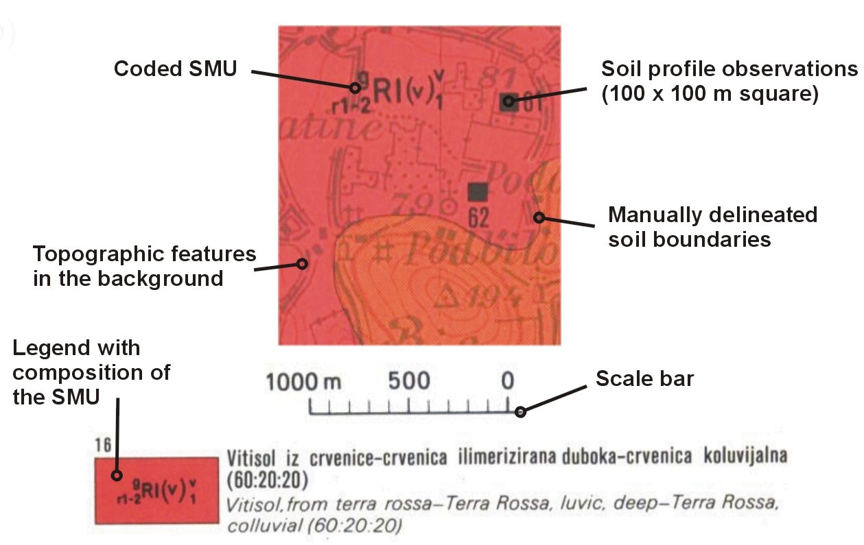
Soil map is a geographical representation showing diversity of soil types and/or soil properties (soil pH, soil texture, textures, organic matter, depths of soil horizons, horizons etc.) in the area of interest. It is typically the end result of a soil survey inventory, i.e. soil survey. Soil maps are most commonly used for land evaluation, spatial planning, agricultural extension, environmental protection and similar projects. Traditional soil maps typically show only general distribution of soils, accompanied by the soil survey report. Many new soil maps are derived using digital soil mapping techniques. Such maps are typically richer in context and show higher spatial detail than traditional soil maps. Soil maps produced using (geo)statistical techniques also include an estimate of the model uncertainty. In the digital era, soil maps come in various digital vector and raster formats and are used for various applications in geosciences and environmental sciences. In this context ... [...More Info...] [...Related Items...] OR: [Wikipedia] [Google] [Baidu] |
Forest Soils
A forest is an area of land dominated by trees. Hundreds of definitions of forest are used throughout the world, incorporating factors such as tree density, tree height, land use, legal standing, and ecological function. The United Nations' Food and Agriculture Organization (FAO) defines a forest as, "Land spanning more than 0.5 hectares with trees higher than 5 meters and a canopy cover of more than 10 percent, or trees able to reach these thresholds ''in situ''. It does not include land that is predominantly under agricultural or urban use." Using this definition, '' Global Forest Resources Assessment 2020'' (FRA 2020) found that forests covered , or approximately 31 percent of the world's land area in 2020. Forests are the predominant terrestrial ecosystem of Earth, and are found around the globe. More than half of the world's forests are found in only five countries (Brazil, Canada, China, Russia, and the United States). The largest share of forests (45 percent) are in t ... [...More Info...] [...Related Items...] OR: [Wikipedia] [Google] [Baidu] |


