|
Hiw Island
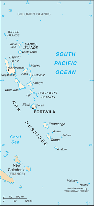
Hiw (sometimes spelled ''Hiu'') is the northernmost island in Vanuatu, located in Torba Province. Name The island's name ''Hiw'' is taken from the local Hiw language; it is known as ''Hiu'' in neighboring Lo-Toga. Etymologically, these forms reflect Proto-Torres-Banks *''siwo'', from Proto-Oceanic *''sipo'' “(go) down”, understood here in its geocentric sense of “located northwest”. Geography Hiw is the largest island in the Torres Islands in Torba Province. It is situated east of the Torres Trench, south of Vanikoro in the Solomon Islands. It has an area of . The highest point is Mount Wonvara (. Hiw's climate is humid tropical. The average annual rainfall is about 4000 mm. The island is subject to frequent cyclones and earthquakes. ''Vewoag Point'' (locally called ''Ngrë Twome''), the northern cape of Hiw, is the northernmost point of land of Vanuatu. of Hiw is a submerged coral reef, ''Ngwey Gakwe'' (formerly ''Recif Giraudeau''), over which the waves br ... [...More Info...] [...Related Items...] OR: [Wikipedia] [Google] [Baidu] |
Pacific Ocean
The Pacific Ocean is the largest and deepest of Earth's five oceanic divisions. It extends from the Arctic Ocean in the north to the Southern Ocean (or, depending on definition, to Antarctica) in the south, and is bounded by the continents of Asia and Oceania in the west and the Americas in the east. At in area (as defined with a southern Antarctic border), this largest division of the World Ocean—and, in turn, the hydrosphere—covers about 46% of Earth's water surface and about 32% of its total surface area, larger than Earth's entire land area combined .Pacific Ocean . '' Britannica Concise.'' 2008: Encyclopædia Britannica, Inc. The centers of both the |
Torres Trench
Torres may refer to: People *Torres (surname), a Spanish and Portuguese surname *Torres (musician), singer-songwriter Mackenzie Scott ** ''Torres'' (album), 2013 self-titled album by Torres Places Americas *Torres, Colorado, an unincorporated community *Torres, Rio Grande do Sul, a city in the state of Rio Grande do Sul in Brazil *Torres, Riverside County, California, Cahuilla village site in California *Torres Municipality, Lara, Venezuela *Torres del Paine, a mountain group in Torres del Paine National Park in the Patagonia region of Chile Europe *Porto Torres, a commune and city in the Sassari province of Sardinia (Italy) *Torres Novas, a municipality in the Santarém district of Portugal *Torres Vedras, a city and a municipality in the Lisbon district of Portugal * Logudoro/Torres, historical region, Sardinia, Italy Spain * Torres, a municipality in the province of Jaén, Andalusia * Torres de Albánchez, a municipality in the province of Jaén * Torres Torres, a municipa ... [...More Info...] [...Related Items...] OR: [Wikipedia] [Google] [Baidu] |
Hiw Island
Hiw (sometimes spelled ''Hiu'') is the northernmost island in Vanuatu, located in Torba Province. Name The island's name ''Hiw'' is taken from the local Hiw language; it is known as ''Hiu'' in neighboring Lo-Toga. Etymologically, these forms reflect Proto-Torres-Banks *''siwo'', from Proto-Oceanic *''sipo'' “(go) down”, understood here in its geocentric sense of “located northwest”. Geography Hiw is the largest island in the Torres Islands in Torba Province. It is situated east of the Torres Trench, south of Vanikoro in the Solomon Islands. It has an area of . The highest point is Mount Wonvara (. Hiw's climate is humid tropical. The average annual rainfall is about 4000 mm. The island is subject to frequent cyclones and earthquakes. ''Vewoag Point'' (locally called ''Ngrë Twome''), the northern cape of Hiw, is the northernmost point of land of Vanuatu. of Hiw is a submerged coral reef, ''Ngwey Gakwe'' (formerly ''Recif Giraudeau''), over which the waves br ... [...More Info...] [...Related Items...] OR: [Wikipedia] [Google] [Baidu] |
Linua
Linua is an island in the Torres Islands archipelago in Torba Province of Vanuatu in the southwestern Pacific Ocean. Geography Linua has a length of 2.8 km and diameter of 1 km. The estimated terrain elevation above sea level is 23 meters. Linua lies about 60 miles (100 km) north of Espiritu Santo Island between islands of Tegua and Lo. The island is surrounded by coral reefs. There is an airstrip on the island opened in 1983 that provides the only regular transportation flights with the rest of Vanuatu. The island is used mostly in times of plane landing, and is not settled permanently; the people there are based in the neighbouring village of Lungharegi, on Lo island. Linua has a small tourist hamlet, Kamilisa, consisting of four bungalows and a capacity of up to 20 people. Climate Linua has a tropical rainforest climate (Af) with very heavy rainfall year-round. Name The island is locally called ''Linue'' in Lo-Toga. The official name ''Linua'' is spelled ... [...More Info...] [...Related Items...] OR: [Wikipedia] [Google] [Baidu] |

.jpg)