|
Hertford East Branch Line
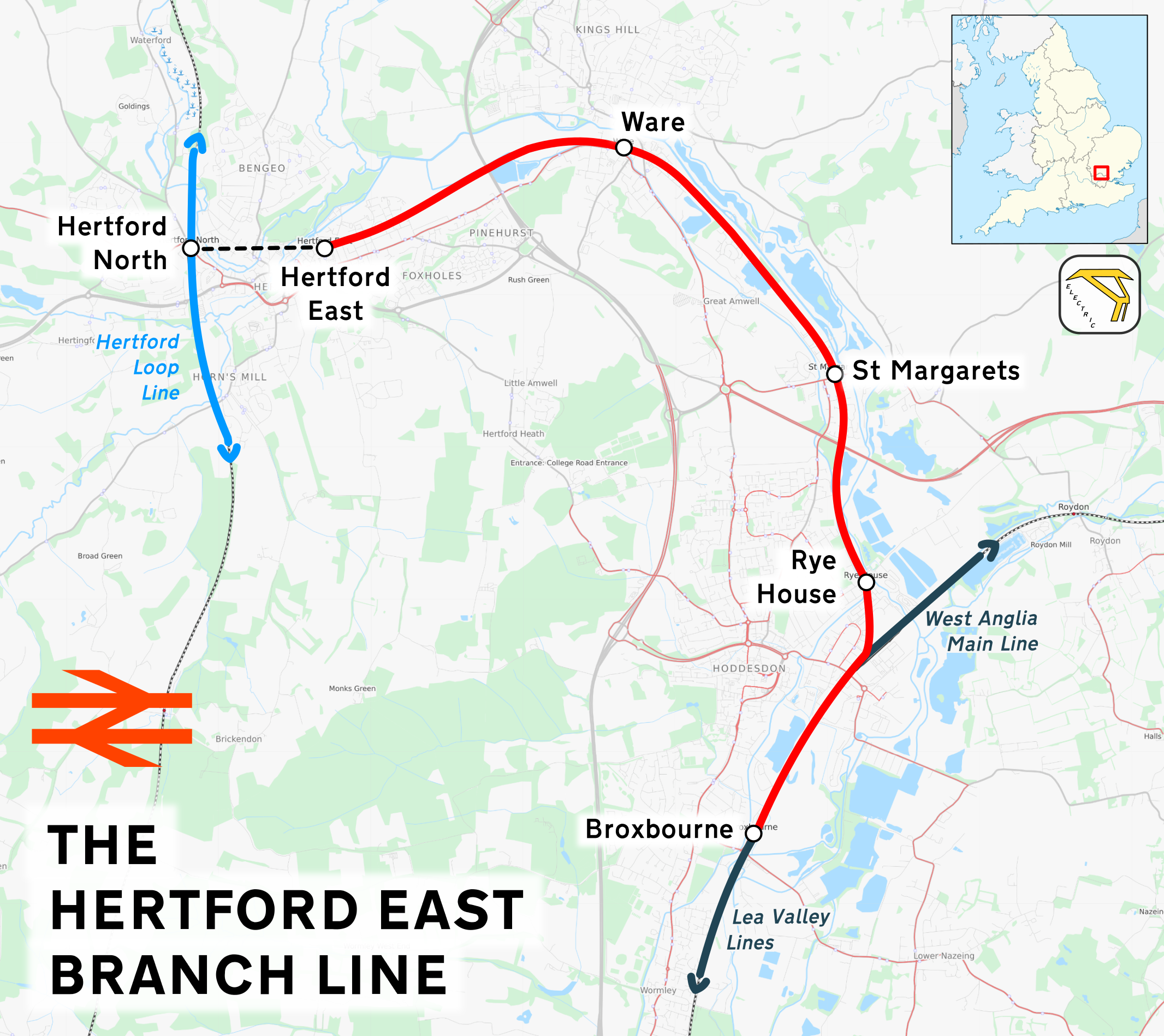
The Hertford East branch line is a railway line in Hertfordshire in the United Kingdom, running between Hertford East and . The line follows the route of the Lea Valley, serving intermediate towns and villages. It branches off the West Anglia Main Line north of , and could be seen as part of the Lea Valley lines—a collection of commuter routes into London. It is in length. History In June 1841 the Northern and Eastern Railway (N&ER) was given parliamentary assent to construct a branch from Broxbourne to Hertford. Work on the line began early in 1843 and the branch (and all stations on it) was opened as a single track on 31 October of that year. Operation by the N&ER was short-lived as it had already agreed that the Eastern Counties Railway would lease its lines (then from Stratford to Bishop's Stortford as well as the Hertford East branch). The line was doubled in October 1846. The original Hertford station was opened in 1843. It was sited to avoid two nearby schools, but l ... [...More Info...] [...Related Items...] OR: [Wikipedia] [Google] [Baidu] |
Heavy Rail
Various terms are used for passenger railway lines and equipment; the usage of these terms differs substantially between areas: Rapid transit A rapid transit system is an electric railway characterized by high speed (~) and rapid acceleration. It uses passenger railcars operating singly or in multiple unit trains on fixed rails. It operates on separate rights-of-way from which all other vehicular and foot traffic are excluded (i.e. is fully grade-separated from other traffic). It uses sophisticated signaling systems, and high platform loading. Originally, the term ''rapid transit'' was used in the 1800s to describe new forms of quick urban public transportation that had a right-of-way separated from street traffic. This set rapid transit apart from horsecars, trams, streetcars, omnibuses, and other forms of public transport. A variant of the term, ''mass rapid transit (MRT)'', is also used for metro systems in Southeast Asia and Taiwan. Though the term was almost alway ... [...More Info...] [...Related Items...] OR: [Wikipedia] [Google] [Baidu] |
Eastern Counties Railway
The Eastern Counties Railway (ECR) was an English Rail transport, railway company incorporated in 1836 intended to link London with Ipswich via Colchester, and then extend to Norwich and Great Yarmouth, Yarmouth. Construction began in 1837 on the first nine miles at the London end. Construction was beset by engineering and other problems, leading to severe financial difficulties. As a result, the project was truncated at Colchester in 1843 but through a series of acquisitions (including the Eastern Union Railway who completed the link between Colchester and Norwich) and opening of other lines, the ECR became the largest of the East Anglian railways. In 1862 ECR was merged with a number of other companies to form the Great Eastern Railway. Opening In 1835 a surveyor called Henry Sayer presented a plan for a new railway from London to York via Cambridge to London solicitors Dimes & Boyman. Together with John Clinton Robertson who was to become the first secretary of the ECR and e ... [...More Info...] [...Related Items...] OR: [Wikipedia] [Google] [Baidu] |
Stanstead St Margarets
Stanstead St Margarets, often abbreviated to just St Margarets, is a village and civil parish in the district of East Hertfordshire, Hertfordshire, England. It is located halfway between the towns of Hoddesdon and Ware. The village is separated from the village of Stanstead Abbotts by the River Lea, and had a population of 1,318 at the census of 2001, increasing to 1,652 at the 2011 Census. Geography The Greenwich Meridian (longitude 0°) passes through the village with its exact position marked by Meridian obelisks which were erected in 1984 to commemorate the centenary of the adoption of the prime meridian line. The current line is one of many that have existed, however the Global Positioning Satellite (GPS) system uses a prime meridian that is about 100 metres east of the Greenwich Meridian at Stanstead Abbotts. Transport The village is served by St Margarets station on the Hertford East Line, operated by Abellio Greater Anglia. St Margarets station was formerly the jun ... [...More Info...] [...Related Items...] OR: [Wikipedia] [Google] [Baidu] |
Hoddesdon
Hoddesdon () is a town in the Borough of Broxbourne, Hertfordshire, lying entirely within the London Metropolitan Area and Greater London Urban Area. The area is on the River Lea and the Lee Navigation along with the New River. Hoddesdon is the second most populated town in Broxbourne with a population of 42,253 according to the United Kingdom's 2011 census. It borders Ware to the North, Nazeing in Essex to the East, and Broxbourne to the South. The Prime Meridian passes just to the east of Hoddesdon. The town is served by Rye House railway station and nearby Broxbourne railway station. History Early history The name "Hoddesdon" is believed to be derived from a Saxon or Danish personal name combined with the Old English suffix "don", meaning a down or hill. The earliest historical reference to the name is in the Domesday Book within the hundred of Hertford. Hoddesdon was situated about north of London on the main road to Cambridge and to the north. The road forked in ... [...More Info...] [...Related Items...] OR: [Wikipedia] [Google] [Baidu] |
Rye House, Hertfordshire
Rye House in Hoddesdon, Hertfordshire is a former fortified manor house, located in what is now the Lee Valley Regional Park. The gatehouse is the only surviving part of the structure and is a Grade I listed building. The house gave its name to the Rye House Plot The Rye House Plot of 1683 was a plan to assassinate King Charles II of England and his brother (and heir to the throne) James, Duke of York. The royal party went from Westminster to Newmarket to see horse races and were expected to make the ..., an assassination attempt of 1683 that was a violent consequence of the Exclusion Crisis in British politics at the end of the 1670s. History The ownership of Rye House was very stable over four centuries; but the fabric gradually ran down, and the buildings diminished. Foundation Andres Pedersen, a Danish soldier who took part in the Hundred Years' War, was denization, denizenised in England in 1433, becoming Sir Andrew Ogard. In 1443 he was allowed to impark part of th ... [...More Info...] [...Related Items...] OR: [Wikipedia] [Google] [Baidu] |
Broxbourne
Broxbourne is a town and former civil parish, now in the unparished area of Hoddesdon, in the Broxbourne district, in Hertfordshire, England, north of London, with a population of 15,303 at the 2011 Census.Broxbourne Town population 2011 It is located to the south of Hoddesdon and to the north of Cheshunt. The town is near the River Lea, which forms the boundary with Essex, and north of the M25 motorway. To the west of the town are Broxbourne Woods, a national nature reserve. The Prime Meridian runs just east of Broxbourne. The town of Broxbourne is not to be confused with the Borough of Broxbourne. The town has the same name as the borough, but is much smaller. Name The name is believed to derive from the Old English words ''brocc'' and ''burna'' meaning ''Badger stream''. History Broxbourne grew around inns on the Great Cambridge Road, now known as the A10. A number of old houses and inns dating from the 16th to the 19th centuries still line the High Street (now the ... [...More Info...] [...Related Items...] OR: [Wikipedia] [Google] [Baidu] |
Lee Navigation
The Lee Navigation is a canalised river incorporating the River Lea (also called the River Lee along the sections that are navigable). It flows from Hertford Castle Weir to the River Thames at Bow Creek; its first lock is Hertford Lock and its last Bow Locks. Name The Lee Navigation is named by Acts of Parliament and is so marked on Ordnance Survey maps. Constructed elements and human features are spelled Lee, such as the canal system and Lee Valley Park. The un-canalized river is spelled Lea, along with other natural features such as Lower Lea Valley. History The River Lea is a major tributary of the River Thames. It has a long association with navigation, as the marshes of Walthamstow have produced a dugout canoe from the Bronze Age and parts of a Saxon barge. According to the ''Anglo-Saxon Chronicle'', the river was used by Viking raiders, and King Alfred changed the level of the river to strand Guthrum and his fleet. In more peaceful times, it became important for the ... [...More Info...] [...Related Items...] OR: [Wikipedia] [Google] [Baidu] |
River Lea
The River Lea ( ) is in South East England. It originates in Bedfordshire, in the Chiltern Hills, and flows southeast through Hertfordshire, along the Essex border and into Greater London, to meet the River Thames at Bow Creek. It is one of the largest rivers in London and the easternmost major tributary of the Thames. The river's significance as a major east–west barrier and boundary has tended to obscure its importance as north–south trade route. Below Hertford the river has since medieval times had alterations made to make it more navigable for boats between the Thames and eastern Hertfordshire and Essex, known as the Lee Navigation. This stimulated much industry along its banks. The navigable River Stort, the main tributary, joins it at Hoddesdon. While the lower Lea remains somewhat polluted, its upper stretch and tributaries, classified as chalk streams, are a major source of drinking water for London. An artificial waterway known as the New River, opened in 1613, ... [...More Info...] [...Related Items...] OR: [Wikipedia] [Google] [Baidu] |
New River (London)
The New River is an artificial waterway in England, opened in 1613 to supply London with fresh drinking water taken from Chadwell and Amwell Springs near Ware in Hertfordshire, and later the River Lea and other sources. Originally conceived by Edmund Colthurst and completed by Hugh Myddelton, it was operated by the New River Company for nearly 300 years until London's water supply was taken over by the Metropolitan Water Board in 1904. Although it was at one time threatened with closure, a large section of the New River remains part of London's water supply infrastructure, more than 400 years after it was first constructed. It is now operated by Thames Water. The New River originally followed the land contours but certain parts have been straightened over the centuries. There is a designated walking route along the canal called the New River Path. It is a 28-mile (45 km) long-distance footpath which follows the course of the New River as closely as possible from its s ... [...More Info...] [...Related Items...] OR: [Wikipedia] [Google] [Baidu] |
London
London is the capital and largest city of England and the United Kingdom, with a population of just under 9 million. It stands on the River Thames in south-east England at the head of a estuary down to the North Sea, and has been a major settlement for two millennia. The City of London, its ancient core and financial centre, was founded by the Romans as '' Londinium'' and retains its medieval boundaries.See also: Independent city § National capitals The City of Westminster, to the west of the City of London, has for centuries hosted the national government and parliament. Since the 19th century, the name "London" has also referred to the metropolis around this core, historically split between the counties of Middlesex, Essex, Surrey, Kent, and Hertfordshire, which largely comprises Greater London, governed by the Greater London Authority.The Greater London Authority consists of the Mayor of London and the London Assembly. The London Mayor is distinguished fr ... [...More Info...] [...Related Items...] OR: [Wikipedia] [Google] [Baidu] |
Buntingford
Buntingford is a market town and civil parish in the district of East Hertfordshire and county of Hertfordshire in England. It lies next to the River Rib and is located on the historic Roman road, Ermine Street. As a result of its location, it grew mainly as a staging post with many coaching inns and has an 18th-century one-cell prison known as The Cage, by the ford at the end of Church Street. It has a population of 6,844, as of the 2020 UK Census. Name Despite popular belief, the name of Buntingford does not come from the bunting bird. Instead, it likely originates from the Saxon chieftain or tribe Bunta and the local ford running over the River Rib. Buntingford was the name of the ford and its surrounding areas, with Bunting being the name of a village located six miles to its north, which is translated from Old English as "place or people of Bunta". The earliest forms of the name Buntingford are ''Buntas Ford'' and ''Buntingeford'', both of which date back to 1185. Th ... [...More Info...] [...Related Items...] OR: [Wikipedia] [Google] [Baidu] |


_p13_-_Our_Starting_Train.jpg)


