Heddon-on-the-Wall
   HOME
*


picture info

Heddon-on-the-Wall
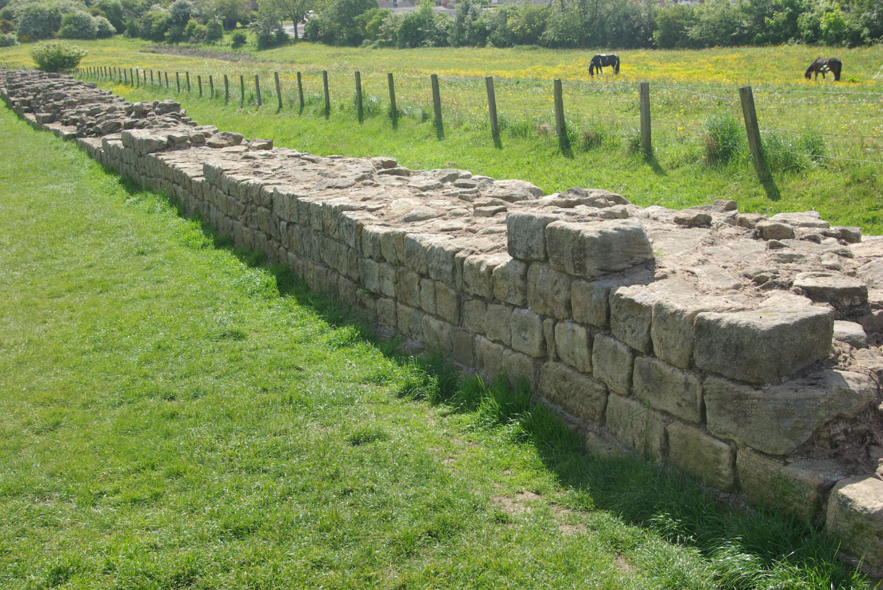
Heddon-on-the-Wall is a village in Northumberland, England, located on Hadrian's Wall. Heddon-on-the-Wall is roughly west of the centre of Newcastle upon Tyne, and just outside Throckley. The place-name 'Heddon' means 'hill where heather grew'. Etymology The place-name ' Heddon on the Wall' is first attested in the Pipe Rolls for 1175, where it appears as ''Hedun''. It appears as ''Heddun'' in 1262 and as ''Hedon super murum'' ('Heddon above the wall') in 1242. The name comes from the Old English ''hæth-dūn'', meaning 'hill where heather grew'. The name should not be confused with that of East Heddon and West Heddon, where the name means 'Hidda's pasture'. History A Roman milecastle (' Milecastle 12') was located at the site of the present-day village, under what is now Town Farm, but no traces of it are currently visible. Prior to the 1960s, Heddon-on-the-Wall was a small village with an economy based strongly on traditional industry including farming and coal mining. La ...
[...More Info...]      
[...Related Items...]     OR:     [Wikipedia]   [Google]   [Baidu]  


Heddon On The Wall Railway Station
Heddon-on-the-Wall railway station served the village of Heddon-on-the-Wall, Northumberland, England from 1881 to 1958. History The station opened in July 1881 by the Scotswood, Newburn and Wylam Railway. It was situated where Station Road (southeast of Heddon village) meets the National Cycle Route, which follows the railway trackbed. Lemington colliery had to be moved north to accommodate the up platform. Nearby were Heddon Colliery and firebrick works, Bank Farm and Sir John Jackson sidings. In 1911, 14,124 tickets were sold but this dropped to 2,428 in 1951. The station closed to both passengers and goods traffic on 15 September 1958. References External links

Disused railway stations in Northumberland Former North Eastern Railway (UK) stations Railway stations in Great Britain opened in 1881 Railway stations in Great Britain closed in 1958 1881 establishments in England 1958 disestablishments in England {{NorthEastEngland-railstation-stub ...
[...More Info...]      
[...Related Items...]     OR:     [Wikipedia]   [Google]   [Baidu]  


Milecastle 12
Milecastle 12 (Heddon) was a milecastle of the Roman Hadrian's Wall. Its remains lay under Town Farm, Heddon-on-the-Wall, (just opposite the farm house) with nothing visible on the surface. Construction Milecastle 12 is of unknown axis and gateway types. Excavations and investigations *circa 1746 - During construction of the Military Road, two inscriptions were discovered (presumed to be from the Heddon-on-the-Wall area). These attest rebuilding work by the Legio VI Victrix. One reads "LEG·VI·V·P·F·REF·TER·ET·SAC·COS", referring to Tertullus and Sacerdos (Consuls for 158AD). *1752 – A large hoard of coins in wooden boxes is found here. *1820 – A small hoard of coins is found near here. These comprise coins from Emperor Maximian (286 – 305 AD) to Emperor Arcadius (383 – 408 AD). *1926 – The north gate is recorded as having been found. *1928–29 – A further search is made, without success. *1966 – English Heritage Field Investigation. It was noted ...
[...More Info...]      
[...Related Items...]     OR:     [Wikipedia]   [Google]   [Baidu]  


picture info

Hadrian's Wall Path
Hadrian's Wall Path is a long-distance footpath in the north of England, which became the 15th National Trail in 2003. It runs for , from Wallsend on the east coast of England to Bowness-on-Solway on the west coast. For most of its length it is close to the remains of Hadrian's Wall, the defensive wall built by the Romans on the northern border of their empire. This is now recognised as part of the " Frontiers of the Roman Empire" World Heritage Site. Path description Though muddy in places, the walking is relatively easy, as the highest point on the path is only 345 m (1130 ft) high and for much of its length the path is more or less flat. Most of the Wall runs through remote countryside but there are sections that pass through the cities and suburbs of Newcastle and Carlisle. The path is well signposted. For most of the walk there are many signs of human activity, and many other walkers in summer. Though there are villages and farms near to the path, there ar ...
[...More Info...]      
[...Related Items...]     OR:     [Wikipedia]   [Google]   [Baidu]  


picture info

Throckley
Throckley is a village located in Newcastle upon Tyne, North East England, approximately west of Newcastle city centre. Hadrian's Wall passed through the village, its course traced by the village's main road, Hexham Road. Throckley lies within the historic county of Northumberland. Throckley was a colliery village, being adjacent to Throckley Colliery, but with the decline in the coal-mining industry the village has become more urbanised. One of Throckley's more notable residents was William Brown, a consulting engineer in the 18th century, and part owner of Throckley Colliery, who was responsible for the construction of many colliery waggonways throughout the North East of England. As a youngster, George Stephenson worked on Dewley farm which lies to the north of the A69. Throckley neighbours the villages of Newburn, Walbottle, Blucher, and across the border in Northumberland, Heddon-on-the-Wall. The village expanded with a number of new housing estates having been develope ...
[...More Info...]      
[...Related Items...]     OR:     [Wikipedia]   [Google]   [Baidu]  


picture info

2001 UK Foot And Mouth Crisis
The outbreak of foot-and-mouth disease in the United Kingdom in 2001 caused a crisis in British agriculture and tourism. This epizootic saw 2,000 cases of the disease in farms across most of the British countryside. Over 6 million cows and sheep were killed in an eventually successful attempt to halt the disease. Cumbria was the worst affected area of the country, with 893 cases. With the intention of controlling the spread of the disease, public rights of way across land were closed by order. This damaged the popularity of the Lake District as a tourist destination and led to the cancellation of that year's Cheltenham Festival, as well as the British Rally Championship for the 2001 season and delaying that year's general election by a month. Crufts, the dog-based festival had to be postponed by 2 months from March to May 2001. By the time that the disease was halted in October 2001, the crisis was estimated to have cost the United Kingdom £8bn. Background Britain's ...
[...More Info...]      
[...Related Items...]     OR:     [Wikipedia]   [Google]   [Baidu]  


picture info

Hexham (UK Parliament Constituency)
Hexham is a constituency in Northumberland represented in the House of Commons of the UK Parliament since 2010 by Guy Opperman, a Conservative. As with all constituencies, the constituency elects one Member of Parliament (MP) by the first past the post system of election at least every five years. The seat was created as one of four single member divisions of the county of Northumberland under the Redistribution of Seats Act 1885. Constituency profile The second-largest constituency by land area in England (covering 250,992 hectares), Hexham reaches to the Pennines and is traversed by Hadrian's Wall, which runs almost due east–west through England. It includes substantial agricultural holdings, forestry, wood processing, food, minerals, and manufactured hardware industries. In the midst of the northwest of the constituency is Kielder Water; running between this area and the middle of the seat is the southern portion of Kielder Forest, and in the west, the attractions of the ...
[...More Info...]      
[...Related Items...]     OR:     [Wikipedia]   [Google]   [Baidu]  


picture info

Northumberland
Northumberland () is a county in Northern England, one of two counties in England which border with Scotland. Notable landmarks in the county include Alnwick Castle, Bamburgh Castle, Hadrian's Wall and Hexham Abbey. It is bordered by land on three sides; by the Scottish Borders region to the north, County Durham and Tyne and Wear to the south, and Cumbria to the west. The fourth side is the North Sea, with a stretch of coastline to the east. A predominantly rural county with a landscape of moorland and farmland, a large area is part of Northumberland National Park. The area has been the site of a number of historic battles with Scotland. Name The name of Northumberland is recorded as ''norð hẏmbra land'' in the Anglo-Saxon Chronicle, meaning "the land north of the Humber". The name of the kingdom of ''Northumbria'' derives from the Old English meaning "the people or province north of the Humber", as opposed to the people south of the Humber Estuary. History ...
[...More Info...]      
[...Related Items...]     OR:     [Wikipedia]   [Google]   [Baidu]  


picture info

Wylam Brewery
Exhibition Park is a public park connected to the south-eastern corner of the Town Moor, Newcastle upon Tyne, England. The park is home to numerous facilities including sports areas, a boating lake, playgrounds and a skatepark. History The Town Moor Improvement Act 1870 determined that two parcels of land, each of , would be developed for recreation. One would become Leazes Park with the other at the Town Moor. The original location of the park was to be the Bull Park where the City’s bull was penned for stud. The site was the wedge of land at the corner of Claremont Road and the Great North Road. Later this land became the Hancock Museum. The committee realised that the Bull Park was too small for the Exhibition and requested Town Moor recreation ground. This is where the current park is now. The Royal Mining Engineering Jubilee Exhibition was held in 1887 and proved to be a tremendous success, attracting 2,000,000 visitors. The name Exhibition Park was first used duri ...
[...More Info...]      
[...Related Items...]     OR:     [Wikipedia]   [Google]   [Baidu]  


picture info

Agriculture
Agriculture or farming is the practice of cultivating plants and livestock. Agriculture was the key development in the rise of sedentary human civilization, whereby farming of domesticated species created food surpluses that enabled people to live in cities. The history of agriculture began thousands of years ago. After gathering wild grains beginning at least 105,000 years ago, nascent farmers began to plant them around 11,500 years ago. Sheep, goats, pigs and cattle were domesticated over 10,000 years ago. Plants were independently cultivated in at least 11 regions of the world. Industrial agriculture based on large-scale monoculture in the twentieth century came to dominate agricultural output, though about 2 billion people still depended on subsistence agriculture. The major agricultural products can be broadly grouped into foods, fibers, fuels, and raw materials (such as rubber). Food classes include cereals (grains), vegetables, fruits, cooking oils, meat, milk, ...
[...More Info...]      
[...Related Items...]     OR:     [Wikipedia]   [Google]   [Baidu]  


picture info

Salmon
Salmon () is the common name for several list of commercially important fish species, commercially important species of euryhaline ray-finned fish from the family (biology), family Salmonidae, which are native to tributary, tributaries of the North Atlantic (genus ''Salmo'') and North Pacific (genus ''Oncorhynchus'') basin. Other closely related fish in the same family include trout, Salvelinus, char, Thymallus, grayling, Freshwater whitefish, whitefish, lenok and Hucho, taimen. Salmon are typically fish migration, anadromous: they hatch in the gravel stream bed, beds of shallow fresh water streams, migrate to the ocean as adults and live like sea fish, then return to fresh water to reproduce. However, populations of several species are restricted to fresh water throughout their lives. Folklore has it that the fish return to the exact spot where they hatched to spawn (biology), spawn, and tracking studies have shown this to be mostly true. A portion of a returning salmon run ma ...
[...More Info...]      
[...Related Items...]     OR:     [Wikipedia]   [Google]   [Baidu]  


picture info

River Tyne
The River Tyne is a river in North East England. Its length (excluding tributaries) is . It is formed by the North Tyne and the South Tyne, which converge at Warden Rock near Hexham in Northumberland at a place dubbed 'The Meeting of the Waters'. The Tyne Rivers Trust measure the whole Tyne catchment as , containing of waterways. Course North Tyne The North Tyne rises on the Scottish border, north of Kielder Water. It flows through Kielder Forest, and in and out of the border. It then passes through the village of Bellingham before reaching Hexham. South Tyne The South Tyne rises on Alston Moor, Cumbria and flows through the towns of Haltwhistle and Haydon Bridge, in a valley often called the Tyne Gap. Hadrian's Wall lies to the north of the Tyne Gap. Coincidentally, the source of the South Tyne is very close to those of the Tees and the Wear. The South Tyne Valley falls within the North Pennines Area of Outstanding Natural Beauty (AONB) – the second largest of the ...
[...More Info...]      
[...Related Items...]     OR:     [Wikipedia]   [Google]   [Baidu]  


picture info

Limestone
Limestone ( calcium carbonate ) is a type of carbonate sedimentary rock which is the main source of the material lime. It is composed mostly of the minerals calcite and aragonite, which are different crystal forms of . Limestone forms when these minerals precipitate out of water containing dissolved calcium. This can take place through both biological and nonbiological processes, though biological processes, such as the accumulation of corals and shells in the sea, have likely been more important for the last 540 million years. Limestone often contains fossils which provide scientists with information on ancient environments and on the evolution of life. About 20% to 25% of sedimentary rock is carbonate rock, and most of this is limestone. The remaining carbonate rock is mostly dolomite, a closely related rock, which contains a high percentage of the mineral dolomite, . ''Magnesian limestone'' is an obsolete and poorly-defined term used variously for dolomite, for limes ...
[...More Info...]      
[...Related Items...]     OR:     [Wikipedia]   [Google]   [Baidu]