|
Hatfield Neolithic Trackway
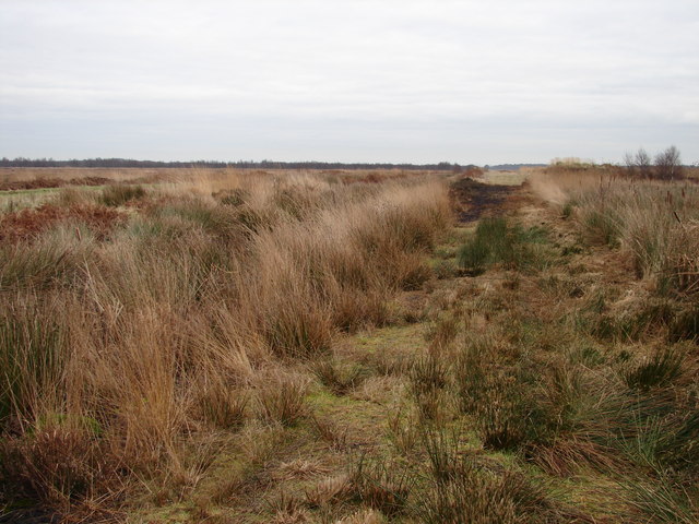
The Hatfield Neolithic Trackway (Lindholme Trackway) was discovered in 2004, and is one of the oldest known ancient timber trackways in England. The trackway is the second confirmed archaeological structure from Hatfield and Thorne Moors. The Lindholme Trackway dates to around 2900–2500 BC. Context Situated in the Humberhead Levels, Hatfield Moor and Thorne Moor form part of the largest raised peat mire in England. The moors have been drained, improved for agriculture and the peat extracted for fuel and compost since the Bronze Age; however, these processes were continually industrialised from the 17th century until the late 20th century. Hatfield Moor and Thorne Moor are currently undergoing a long term management plan of restoration and conservation. Discovery In October 2004 a number of worked wooden poles were discovered by a local man, Mick Oliver, who was walking across the site. The site is sometimes known as the Oliver Track (presumably in comparison to the Swee ... [...More Info...] [...Related Items...] OR: [Wikipedia] [Google] [Baidu] |
Ancient Trackway
Historic roads (historic trails in USA and Canada) are paths or routes that have historical importance due to their use over a period of time. Examples exist from prehistoric times until the early 20th century. They include ancient trackways, long-lasting roads, important trade routes, and migration trails. Many historic routes, such as the Silk Road, the Amber Road, and the Royal Road of the Persian Empire, covered great distances and their impact on human settlements remain today. The Post Track, a prehistoric causeway in the valley of the River Brue in the Somerset Levels, England, is one of the oldest known constructed trackways and dates from around 3800 BCE. The world's oldest known paved road was constructed in Egypt some time between 2600 and 2200 BC. The Romans were the most significant road builders of the ancient world. At the peak of the Roman Empire there were more than of roads, of which over were stone-paved.Gabriel, Richard A. ''The Great Armies of Anti ... [...More Info...] [...Related Items...] OR: [Wikipedia] [Google] [Baidu] |
Humberhead Levels
The Humberhead Levels is a national character area covering a large expanse of flat, low-lying land towards the western end of the Humber estuary in northern England. The levels occupy the former Glacial Lake Humber, an area bounded to the east by the Yorkshire Wolds and the northern Lincolnshire Edge, a limestone escarpment, and to the west by the southern part of the Yorkshire magnesian limestone ridge. In the north the levels merge into the slightly more undulating Vale of York close to the Escrick glacial moraine, and to the south merge into the Trent Vale. Glacial Lake Humber During the last ice age, a glacier extended across this area almost to where Doncaster now is. The main glacial front was at Escrick where the Escrick moraine marks its furthest extension. This was the northern limit of an extensive lake which was impounded by the blocking of the Humber Gap by another ice front. The lake bottom gradually filled with clay sediments which are up to 20 metres thick. Th ... [...More Info...] [...Related Items...] OR: [Wikipedia] [Google] [Baidu] |
Thorne And Hatfield Moors
Thorne and Hatfield Moors form the largest area of lowland raised peat bog in the United Kingdom. They are situated in South Yorkshire, to the north-east and east of Doncaster near the town of Thorne, and are part of Hatfield Chase. They had been used for small-scale extraction of peat for fuel from medieval times, and probably much earlier, but commercial extraction of the peat for animal bedding began in the 1880s. The peat was cut on the moors and, once it had dried, transported to several works on narrow gauge tramways, always called trams locally. The wagons were pulled by horses to works at Creyke's Siding, Moorends, Medge Hall, Swinefleet and Hatfield. There was also a network of canals supplying the Moorends Works. The industry suffered a downturn between the two world wars, as working horses were replaced by lorries and peat demand dropped, but after the Second World War peat was used by the horticultural industry in increasing volumes, and harvesting expanded again ... [...More Info...] [...Related Items...] OR: [Wikipedia] [Google] [Baidu] |
Peat
Peat (), also known as turf (), is an accumulation of partially decayed vegetation or organic matter. It is unique to natural areas called peatlands, bogs, mires, moors, or muskegs. The peatland ecosystem covers and is the most efficient carbon sink on the planet, because peatland plants capture carbon dioxide (CO2) naturally released from the peat, maintaining an equilibrium. In natural peatlands, the "annual rate of biomass production is greater than the rate of decomposition", but it takes "thousands of years for peatlands to develop the deposits of , which is the average depth of the boreal orthernpeatlands", which store around 415 gigatonnes (Gt) of carbon (about 46 times 2019 global CO2 emissions). Globally, peat stores up to 550 Gt of carbon, 42% of all soil carbon, which exceeds the carbon stored in all other vegetation types, including the world's forests, although it covers just 3% of the land's surface. ''Sphagnum'' moss, also called peat moss, is one of th ... [...More Info...] [...Related Items...] OR: [Wikipedia] [Google] [Baidu] |
Mire
A mire, peatland, or quagmire is a wetland area dominated by living peat-forming plants. Mires arise because of incomplete decomposition of organic matter, usually litter from vegetation, due to water-logging and subsequent anoxia. All types of mires share the common characteristic of being saturated with water, at least seasonally with actively forming peat, while having their own ecosystem. Like coral reefs, mires are unusual landforms that derive mostly from biological rather than physical processes, and can take on characteristic shapes and surface patterning. A quagmire is a floating (quaking) mire, bog, or any peatland being in a stage of hydrosere or hydrarch (hydroseral) succession, resulting in pond-filling yields underfoot. Ombrotrophic types of quagmire may be called quaking bog (quivering bog). Minerotrophic types can be named with the term quagfen. There are four types of mire: bog, fen, marsh and swamp. A bog is a mire that, due to its location relative to the ... [...More Info...] [...Related Items...] OR: [Wikipedia] [Google] [Baidu] |
Sweet Track
The Sweet Track is an ancient trackway, or causeway, in the Somerset Levels, England, named after its finder, Ray Sweet. It was built in 3807 BC (determined using dendrochronology) and is the second-oldest timber trackway discovered in the British Isles, dating to the Neolithic. It is now known that the Sweet Track was predominantly built along the course of an earlier structure, the Post Track. The track extended across the now largely drained marsh between what was then an island at Westhay and a ridge of high ground at Shapwick, a distance close to or around . The track is one of a network that once crossed the Somerset Levels. Various artifacts and prehistoric finds, including a jadeitite ceremonial axe head, have been found in the peat bogs along its length. Construction was of crossed wooden poles, driven into the waterlogged soil to support a walkway that consisted mainly of planks of oak, laid end-to-end. The track was used for a period of only around ten years a ... [...More Info...] [...Related Items...] OR: [Wikipedia] [Google] [Baidu] |
Paleoecology
Paleoecology (also spelled palaeoecology) is the study of interactions between organisms and/or interactions between organisms and their environments across geologic timescales. As a discipline, paleoecology interacts with, depends on and informs a variety of fields including paleontology, ecology, climatology and biology. Paleoecology emerged from the field of paleontology in the 1950s, though paleontologists have conducted paleoecological studies since the creation of paleontology in the 1700s and 1800s. Combining the investigative approach of searching for fossils with the theoretical approach of Charles Darwin and Alexander von Humboldt, paleoecology began as paleontologists began examining both the ancient organisms they discovered and the reconstructed environments in which they lived. Visual depictions of past marine and terrestrial communities have been considered an early form of paleoecology. Overview of paleoecological approaches * Classic paleoecology uses data from ... [...More Info...] [...Related Items...] OR: [Wikipedia] [Google] [Baidu] |
University Of Birmingham
, mottoeng = Through efforts to heights , established = 1825 – Birmingham School of Medicine and Surgery1836 – Birmingham Royal School of Medicine and Surgery1843 – Queen's College1875 – Mason Science College1898 – Mason University College1900 – gained university status by royal charter , city = Birmingham , province = West Midlands , country = England, UK , coor = , campus = Urban, suburban , academic_staff = 5,495 (2020) , administrative_staff = , head_label = Visitor , head = The Rt Hon Penny Mordaunt MP , chancellor = Lord Bilimoria , vice_chancellor = Adam Tickell , type = Public , endowment = £134.5 million (2021) , budget = £774.1 million (2020–21) , students = () , undergrad = () , postgrad = () , affiliations = Universitas 21Universities UK EUA ACUSutton 13Russell Group , free_label = , free = , colours = The University , website = , logo = The University of Birmingham (informally Birmingham University) i ... [...More Info...] [...Related Items...] OR: [Wikipedia] [Google] [Baidu] |
Historic England
Historic England (officially the Historic Buildings and Monuments Commission for England) is an executive non-departmental public body of the British Government sponsored by the Department for Digital, Culture, Media and Sport. It is tasked with protecting the historic environment of England by preserving and listing historic buildings, scheduling ancient monuments, registering historic Parks and Gardens and by advising central and local government. The body was officially created by the National Heritage Act 1983, and operated from April 1984 to April 2015 under the name of English Heritage. In 2015, following the changes to English Heritage's structure that moved the protection of the National Heritage Collection into the voluntary sector in the English Heritage Trust, the body that remained was rebranded as Historic England. The body also inherited the Historic England Archive from the old English Heritage, and projects linked to the archive such as Britain from Above, w ... [...More Info...] [...Related Items...] OR: [Wikipedia] [Google] [Baidu] |
Ancient Trackways In England
Ancient history is a time period from the beginning of writing and recorded human history to as far as late antiquity. The span of recorded history is roughly 5,000 years, beginning with the Sumerian cuneiform script. Ancient history covers all continents inhabited by humans in the period 3000 BCAD 500. The three-age system periodizes ancient history into the Stone Age, the Bronze Age, and the Iron Age, with recorded history generally considered to begin with the Bronze Age. The start and end of the three ages varies between world regions. In many regions the Bronze Age is generally considered to begin a few centuries prior to 3000 BC, while the end of the Iron Age varies from the early first millennium BC in some regions to the late first millennium AD in others. During the time period of ancient history, the world population was already exponentially increasing due to the Neolithic Revolution, which was in full progress. While in 10,000 BC, the world population stood at ... [...More Info...] [...Related Items...] OR: [Wikipedia] [Google] [Baidu] |


.jpg)


