|
Hale Interchange
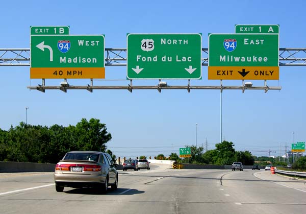
The Hale Interchange is the major interchange between Interstate 41 (I-41), I-43, I-894, US Highway 41 (US 41), and US 45 in the Milwaukee, Wisconsin, southwest suburb of Greenfield, though it takes it name from the nearby community of Hales Corners. Description The Hale Interchange is designed as a directional T interchange that serves I-41, I-43, I-894, US 41, and US 45. I-41 south/I-43 north/I-894 east/US 41 south (Airport Freeway) first heads eastward toward Downtown Milwaukee and Chicago. The freeway is also the direct route to get to Mitchell International Airport. I-43 south (Rock Freeway) heads west from the Hale to Beloit. I-41 north/I-894 west/US 41 north/US 45 north (Zoo Freeway) heads toward Madison and Fond du Lac although those control cities are not signed in the interchange on I-894 itself. US 45 south runs for a mile with I-43 south before exiting at exit 60 onto Wisconsin Highway 100 (108th Street) heading to Ha ... [...More Info...] [...Related Items...] OR: [Wikipedia] [Google] [Baidu] |
Greenfield, Wisconsin
Greenfield is a city in the U.S. state of Wisconsin. Located in Milwaukee County, Greenfield is one of many bedroom communities in the Milwaukee metropolitan area. The population was 37,803 as of the 2020 Census. History On March 8, 1839, the Town of Kinnikennick was created by the territorial legislature, encompassing the western part of the Town of Lake); and on December 20, 1839, the south portion of the Town of Kinnikennick was split off to form the town of Franklin. As of the 1840 census, the population of the Town of Kinnikennick or Kinnikinnick was 404. On February 19, 1841, the name of the town was changed to Greenfield, taking its name from the name of the Post Office in the Town of Kinnickinnic. Greenfield was the final municipality in Milwaukee County to incorporate, and was the final municipality to leave the Town form of government in 1957. This was done to prevent total annexation by the City of Milwaukee. Before 1957, Milwaukee slowly nibbled away at Greenfield's ... [...More Info...] [...Related Items...] OR: [Wikipedia] [Google] [Baidu] |
Mitchell International Airport
Milwaukee Mitchell International Airport is a civil–military airport south of downtown Milwaukee, Wisconsin, United States., effective May 21, 2020. It is included in the Federal Aviation Administration (FAA) National Plan of Integrated Airport Systems for 2023–2027, in which it is categorized as a medium-hub primary commercial service facility. Milwaukee Mitchell International Airport covers and has five asphalt and concrete runways. The airport is named in honor of United States Army General Billy Mitchell, who was raised in Milwaukee and is often regarded as the father of the United States Air Force. Along with being the primary airport for Milwaukee, Mitchell International is also used by travelers throughout Southern and Eastern Wisconsin and Northern Illinois. Since March 1941, the airport's weather station has been used as the official point for Milwaukee weather observations and records by the National Weather Service, whose area office is located in Sullivan. ... [...More Info...] [...Related Items...] OR: [Wikipedia] [Google] [Baidu] |
Transportation In Milwaukee
Transport (in British English), or transportation (in American English), is the intentional movement of humans, animals, and goods from one location to another. Modes of transport include air, land (rail and road), water, cable, pipeline, and space. The field can be divided into infrastructure, vehicles, and operations. Transport enables human trade, which is essential for the development of civilizations. Transport infrastructure consists of both fixed installations, including roads, railways, airways, waterways, canals, and pipelines, and terminals such as airports, railway stations, bus stations, warehouses, trucking terminals, refueling depots (including fueling docks and fuel stations), and seaports. Terminals may be used both for interchange of passengers and cargo and for maintenance. Means of transport are any of the different kinds of transport facilities used to carry people or cargo. They may include vehicles, riding animals, and pack animals. Vehicles may incl ... [...More Info...] [...Related Items...] OR: [Wikipedia] [Google] [Baidu] |
List Of Road Interchanges In The United States
__NOTOC__ The following list contains the most notable road interchanges within the United States divided by each state, which are mainly part of the national Interstate Highway System and are all freeways intersecting with each other at a junction. Some of the biggest ones are: Kennedy Interchange (I-64/I-65/I-71) in Louisville, Kentucky; the Marquette Interchange (I-94/I-43/I-794) and the $1.8 billion Zoo Interchange both in Milwaukee, Wisconsin; the Pregerson Interchange (I-110/I-105) in Los Angeles; and the Circle Interchange (I-90/I-94/I-290) in Chicago. Alabama *Malfunction Junction at I-20/ I-59 and I-65 Arizona * Mini Stack *The Stack * SuperRedTan Interchange Arkansas *Big Rock Interchange, the junction of I-430 and I-630, Little Rock, Arkansas *North Terminal Interchange, the junction of I-40 and I-30, Little Rock, Arkansas *South Terminal Interchange, the junction of I-30, I-440 and I-530, Little Rock, Arkansas California The first stack interchange in the wo ... [...More Info...] [...Related Items...] OR: [Wikipedia] [Google] [Baidu] |
Zoo Interchange
The Zoo Interchange is a freeway interchange on the west side of Milwaukee, Wisconsin. It forms the junction of Interstate 94 (I-94, East–West Freeway), I-894, I-41, US Highway 41 (US 41) and US 45 (Zoo Freeway). It is the busiest and one of the oldest interchanges in the state. It is nicknamed as such because of the Milwaukee County Zoo located on the northwest quadrant of the interchange. The control cities at the interchange are Downtown Milwaukee to the east, Chicago to the south, Madison to the west and Fond du Lac to the north. Originally completed in 1963, the interchange was a major component in the freeway system being developed in Milwaukee and southeastern Wisconsin and formed an important link with the Interstate system. It was considered a wonder of engineering at the time. The design included exits on both the left and right sides of the roadways, and drivers exited depending which side their destination road was on. Owing to the dangers of ... [...More Info...] [...Related Items...] OR: [Wikipedia] [Google] [Baidu] |
Nondestructive Testing
Nondestructive testing (NDT) is any of a wide group of analysis techniques used in science and technology industry to evaluate the properties of a material, component or system without causing damage. The terms nondestructive examination (NDE), nondestructive inspection (NDI), and nondestructive evaluation (NDE) are also commonly used to describe this technology. Because NDT does not permanently alter the article being inspected, it is a highly valuable technique that can save both money and time in product evaluation, troubleshooting, and research. The six most frequently used NDT methods are eddy-current, magnetic-particle, liquid penetrant, radiographic, ultrasonic, and visual testing. NDT is commonly used in forensic engineering, mechanical engineering, petroleum engineering, electrical engineering, civil engineering, systems engineering, aeronautical engineering, medicine, and art. Innovations in the field of nondestructive testing have had a profound impact on medical im ... [...More Info...] [...Related Items...] OR: [Wikipedia] [Google] [Baidu] |
Google Books
Google Books (previously known as Google Book Search, Google Print, and by its code-name Project Ocean) is a service from Google Inc. that searches the full text of books and magazines that Google has scanned, converted to text using optical character recognition (OCR), and stored in its digital database.The basic Google book link is found at: https://books.google.com/ . The "advanced" interface allowing more specific searches is found at: https://books.google.com/advanced_book_search Books are provided either by publishers and authors through the Google Books Partner Program, or by Google's library partners through the Library Project. Additionally, Google has partnered with a number of magazine publishers to digitize their archives. The Publisher Program was first known as Google Print when it was introduced at the Frankfurt Book Fair in October 2004. The Google Books Library Project, which scans works in the collections of library partners and adds them to the digital invent ... [...More Info...] [...Related Items...] OR: [Wikipedia] [Google] [Baidu] |
Wisconsin Highway 100
State Trunk Highway 100 (STH-100, commonly known as Highway 100 or WIS 100) is a road which encircles the outer edges of Milwaukee County, Wisconsin, Milwaukee County, Wisconsin, United States. Route description The road is designed as a Bypass route, bypass around the city of Milwaukee, Wisconsin, Milwaukee, but with residential and commercial development along WIS 100 on almost all portions of the road, this purpose has been negated, and it serves as one of the Milwaukee area's major commercial corridors. WIS 100 roughly parallels the freight railroad beltway around Milwaukee constructed in 1912 by the Chicago and North Western Transportation Company, approximately one mile inside the north, west and south county lines. In Milwaukee's immediate western suburb Wauwatosa, Wisconsin, Wauwatosa, WIS 100's north–south segment was once known as Lovers Lane; parts of the road still have this designation. In the vicinity of Mayfair Mall, Mayfair Shopping Center, it is known as Ma ... [...More Info...] [...Related Items...] OR: [Wikipedia] [Google] [Baidu] |
Fond Du Lac, Wisconsin
Fond du Lac () is a city in Fond du Lac County, Wisconsin, Fond du Lac County, Wisconsin, United States. The population was 44,678 at the 2020 census. The city forms the core of the United States Census Bureau's Fond du Lac United States metropolitan area, Metropolitan Statistical Area, which includes all of Fond du Lac County (2020 population: 104,154). Fond du Lac is the 348th largest Metropolitan Statistical Area (MSA) in the United States. History "Fond du Lac" is French for the "bottom" or the "farthest point" "of the lake," so named because of its location at the bottom (south end) of Lake Winnebago. Native American tribes, primarily the Winnebagos but also the Potawatomi, Kickapoo people, Kickapoo, and Mascoutin lived or gathered in the area long before European explorers arrived. Although the identity of the first European to explore the southern end of Lake Winnebago is uncertain, it was probably Claude-Jean Allouez, followed by French fur trappers. James Duane Dot ... [...More Info...] [...Related Items...] OR: [Wikipedia] [Google] [Baidu] |
Madison, Wisconsin
Madison is the county seat of Dane County and the capital city of the U.S. state of Wisconsin. As of the 2020 census the population was 269,840, making it the second-largest city in Wisconsin by population, after Milwaukee, and the 80th-largest in the U.S. The city forms the core of the Madison Metropolitan Area which includes Dane County and neighboring Iowa, Green, and Columbia counties for a population of 680,796. Madison is named for American Founding Father and President James Madison. The city is located on the traditional land of the Ho-Chunk, and the Madison area is known as ''Dejope'', meaning "four lakes", or ''Taychopera'', meaning "land of the four lakes", in the Ho-Chunk language. Located on an isthmus and lands surrounding four lakes—Lake Mendota, Lake Monona, Lake Kegonsa and Lake Waubesa—the city is home to the University of Wisconsin–Madison, the Wisconsin State Capitol, the Overture Center for the Arts, and the Henry Vilas Zoo. Madison is ho ... [...More Info...] [...Related Items...] OR: [Wikipedia] [Google] [Baidu] |
Beloit, Wisconsin
Beloit is a city in Rock County, Wisconsin, United States. As of the 2020 census, the city had a population of 36,657 people. History Twelve men in Colebrook, New Hampshire, created the "New England Emigrating Company" in October 1836 and sent Horace White to find a suitable region of Wisconsin in which to settle. The level fields and the water power of Turtle Creek and "unlimited gravel" in the area around what is now Beloit fixed the site of the village and farms. White purchased the land. At the same time as the Colebrook settlers, six families from Bedford, New Hampshire, arrived and settled in the region. They said the Rock River Valley had a "New England look" that made them feel at home. The village was platted in 1838 and was planned with wide streets, building on the New England model. Beloit was originally named New Albany (after Albany, Vermont) in 1837 by its founder, Caleb Blodgett. The name was changed to Beloit in 1838.Callary, Edward. 2009. ''Place Names of Ill ... [...More Info...] [...Related Items...] OR: [Wikipedia] [Google] [Baidu] |
Chicago, Illinois
(''City in a Garden''); I Will , image_map = , map_caption = Interactive Map of Chicago , coordinates = , coordinates_footnotes = , subdivision_type = Country , subdivision_name = United States , subdivision_type1 = State , subdivision_type2 = Counties , subdivision_name1 = Illinois , subdivision_name2 = Cook and DuPage , established_title = Settled , established_date = , established_title2 = Incorporated (city) , established_date2 = , founder = Jean Baptiste Point du Sable , government_type = Mayor–council , governing_body = Chicago City Council , leader_title = Mayor , leader_name = Lori Lightfoot ( D) , leader_title1 = City Clerk , leader_name1 = Anna Valencia ( D) , unit_pref = Imperial , area_footnotes = , area_tot ... [...More Info...] [...Related Items...] OR: [Wikipedia] [Google] [Baidu] |


