|
Hydrography Of The San Francisco Bay Area
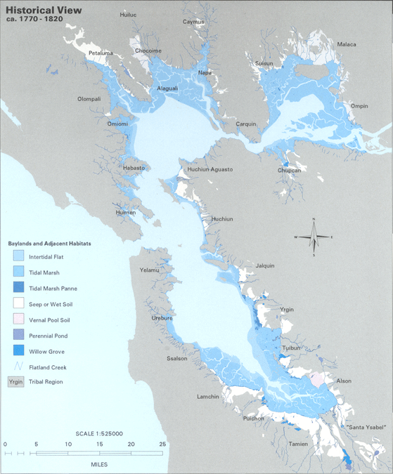
The Hydrography of the San Francisco Bay Area is a complex network of watersheds, marshes, rivers, creeks, reservoirs, and bays predominantly draining into the San Francisco Bay and Pacific Ocean. Bays The largest bodies of water in the Bay Area are the San Francisco Bay, San Pablo Bay, and Suisun Bay. The San Francisco Bay is one of the largest bays in the world. Many inlets on the edges of the three major bays are designated as bays in their own right, such as Richardson Bay, San Rafael Bay, Grizzly Bay, and San Leandro Bay. Nearby bays along the Pacific Coast include Bodega Bay, Tomales Bay, Drakes Bay, Bolinas Bay, and Half Moon Bay. Rivers The largest rivers are the Sacramento and San Joaquin Rivers, which drain into the Sacramento-San Joaquin River Delta and thence to Suisun Bay. Other major rivers of the North Bay are the Napa River, the Petaluma River, the Gualala River, and the Russian River; the former two drain into San Pablo Bay, the latter two into the Pac ... [...More Info...] [...Related Items...] OR: [Wikipedia] [Google] [Baidu] |
Sf Estuary Historical
SF may refer to: Locations * San Francisco, California, United States * Sidi Fredj, Algeria * South Florida, an urban region in the United States * Suomi Finland, former vehicular country code for Finland In arts and entertainment Genres * Speculative fiction (usually ''sf'') ** Science fiction or sci-fi (usually ''SF'') In film and television * , the Swedish film industry ** SF Film Finland, a Finnish film distributor * SF Channel (Australia) * , a German-language television network in Switzerland * , a Finnish film production company In music * Sforzando (musical direction) or sf, a musical accent * ''Subito forte'', a musical notation for dynamics (music) * Switchfoot, a band * Sasha Fierce, on-stage alter ego of American entertainer Beyoncé, and namesake of her album '' I Am... Sasha Fierce'' Other media * Saikoro Fiction, a Japanese role-playing game system * ''Street Fighter'', a series of fighting video games by Capcom Businesses and organizations In ... [...More Info...] [...Related Items...] OR: [Wikipedia] [Google] [Baidu] |
North Bay (San Francisco Bay Area)
The North Bay is a subregion of the San Francisco Bay Area, in California, United States. The largest city is Santa Rosa, which is the fifth-largest city in the Bay Area. It is the location of the Napa and Sonoma wine regions, and is the least populous and least urbanized part of the Bay Area. It consists of Marin, Napa, Solano and Sonoma counties. Transportation The North Bay is connected to San Francisco by the Golden Gate Bridge and to the East Bay by the Richmond–San Rafael Bridge, Carquinez Bridge and the Benicia–Martinez Bridge. Several ferry routes operate between the North Bay and San Francisco, from terminals located in Angel Island, Larkspur, Sausalito, Tiburon and Vallejo. The Sonoma–Marin Area Rail TransitSMART, a commuter rail line from Larkspur to Cloverdale, was approved by voters in November 2008. Passenger service began between the Sonoma County Airport station and San Rafael in August 2017 and was completed as far south as Larkspur in 2019. Hist ... [...More Info...] [...Related Items...] OR: [Wikipedia] [Google] [Baidu] |
Berkeley Hills
The Berkeley Hills are a range of the Pacific Coast Ranges that overlook the northeast side of the valley that encompasses San Francisco Bay. They were previously called the "Contra Costa Range/Hills" (from the original Spanish ''Sierra de la Contra Costa''), but with the establishment of Berkeley and the University of California, the current usage was applied by geographers and gazetteers. Geology The Berkeley Hills are bounded by the major Hayward Fault along their western base, and the minor Wildcat fault on their eastern side. The highest peaks are Grizzly Peak (elevation 1,754 feet/535 m) and Round Top (elevation 1,761 feet/537 m), an extinct volcano, and William Rust Summit 1,004 feet (306 m). Vollmer Peak (elevation 1,905 feet/581 m), although commonly thought to be part of the Berkeley Hills, is actually located on the adjacent San Pablo Ridge near the point where it meets the Berkeley Hills at the head of Wildcat Canyon. Vollmer Peak was named in honor of the ... [...More Info...] [...Related Items...] OR: [Wikipedia] [Google] [Baidu] |
Contra Costa County, California
) of the San Francisco Bay , subdivision_type = Country , subdivision_name = United States , subdivision_type1 = State , subdivision_name1 = California , subdivision_type2 = Region , subdivision_name2 = San Francisco Bay Area , seat_type = County seat , seat = Martinez , parts_type = Largest city , parts = Concord (population and land area)Richmond (total area) , unit_pref = US , area_total_sq_mi = 804 , area_land_sq_mi = 715.94 , area_water_sq_mi = 81 , elevation_max_footnotes = , elevation_max_ft = 3852 , population_as_of = 2020 , population_footnotes = , population_total = 1,165,927 , population_density_sq_mi = 1629 , established_title ... [...More Info...] [...Related Items...] OR: [Wikipedia] [Google] [Baidu] |
Baxter Creek
Baxter Creek or Stege Creek , CreativeDifferences.com, retrieved August 15, 2007 (also archaically Bishop Creek), is a three-branch creek in and El Cerrito, , United States, forming the Baxter Creek watershed. The creek has three sources and flows from the |
San Pablo Creek
, name_native_lang = , name_other = , name_etymology = , image = SanPabloCreek4.JPG , image_caption = San Pablo Creek just behind the El Sobrante Library , image_size = 300 , map = , map_size = , map_caption = , pushpin_map = USA California , pushpin_map_size = 300 , pushpin_map_caption= Location of the mouth of San Pablo Creek in California , subdivision_type1 = Country , subdivision_name1 = United States , subdivision_type2 = State , subdivision_name2 = California , subdivision_type3 = Region , subdivision_name3 = Contra Costa County , subdivision_type4 = , subdivision_name4 = , subdivision_type5 = , subdivision_name5 = , length = , width_min = , width_avg = , width_max = , depth_min = , depth_avg = , depth_max = , discharge1_location= , discharge1_min = , discharge1_a ... [...More Info...] [...Related Items...] OR: [Wikipedia] [Google] [Baidu] |
Santa Rosa Creek
Santa Rosa Creek is a 22-mile-long (35 km) stream in Sonoma County, California, which rises on Hood Mountain and discharges to the Laguna de Santa Rosa by way of the Santa Rosa Flood Control Channel. This article covers both the creek and the channel. Description Though it begins as a wild stream in the Mayacamas Mountains, Santa Rosa Creek is culverted for part of its course through Santa Rosa, California, the city of Santa Rosa's downtown. The riparian area has a rich prehistoric past with settlement of the Southern Pomo people on much of the middle and lower reach banks. A significant stream restoration project was created in the downtown Santa Rosa reach in the late 1990s, allowing Rainbow trout, steelhead and coho salmon to migrate to productive upstream Spawn (biology), spawning areas. Major tributaries to Santa Rosa Creek include Brush Creek (Sonoma County, California), Brush Creek, Piner Creek, Matanzas Creek and Colgan Creek. Annual Precipitation (meteorology), p ... [...More Info...] [...Related Items...] OR: [Wikipedia] [Google] [Baidu] |
Spanish Language
Spanish ( or , Castilian) is a Romance languages, Romance language of the Indo-European language family that evolved from colloquial Latin spoken on the Iberian peninsula. Today, it is a world language, global language with more than 500 million native speakers, mainly in the Americas and Spain. Spanish is the official language of List of countries where Spanish is an official language, 20 countries. It is the world's list of languages by number of native speakers, second-most spoken native language after Mandarin Chinese; the world's list of languages by total number of speakers, fourth-most spoken language overall after English language, English, Mandarin Chinese, and Hindustani language, Hindustani (Hindi-Urdu); and the world's most widely spoken Romance languages, Romance language. The largest population of native speakers is in Mexico. Spanish is part of the Iberian Romance languages, Ibero-Romance group of languages, which evolved from several dialects of Vulgar Latin in I ... [...More Info...] [...Related Items...] OR: [Wikipedia] [Google] [Baidu] |
Streams
A stream is a continuous body of water, body of surface water Current (stream), flowing within the stream bed, bed and bank (geography), banks of a channel (geography), channel. Depending on its location or certain characteristics, a stream may be referred to by a variety of local or regional names. Long large streams are usually called rivers, while smaller, less voluminous and more intermittent river, intermittent streams are known as streamlets, brooks or creeks. The flow of a stream is controlled by three inputs – surface runoff (from precipitation or meltwater), daylighting (streams), daylighted subterranean river, subterranean water, and surfaced groundwater (Spring (hydrology), spring water). The surface and subterranean water are highly variable between periods of rainfall. Groundwater, on the other hand, has a relatively constant input and is controlled more by long-term patterns of precipitation. The stream encompasses surface, subsurface and groundwater fluxes th ... [...More Info...] [...Related Items...] OR: [Wikipedia] [Google] [Baidu] |
Alviso, San Jose, California
Alviso is a district of San Jose, California, located in North San Jose on the southern shores of San Francisco Bay. Originally an independent town, founded in 1852, today Alviso is San Jose's only waterfront district, primarily residential in nature, with several Silicon Valley tech companies and recreation-oriented businesses. Alviso is named after 19th-century Californio ranchero Ignacio Alviso, who owned the area as part of his Rancho Rincón de Los Esteros. The Guadalupe River separates Alviso from Santa Clara and Sunnyvale to the west, while Coyote Creek separates Alviso from Milpitas to the east. Alviso is the lowest point in the San Francisco Bay Area at below sea level. History Alviso was first settled in the 18th century. The community was named for Ignacio Alviso, the son of Corporal Domingo Alviso, one of the original members of the de Anza expedition. Corporal Alviso lived but a short time after reaching San Francisco and was buried March 11, 1777. Alviso's de ... [...More Info...] [...Related Items...] OR: [Wikipedia] [Google] [Baidu] |
Guadalupe River (California)
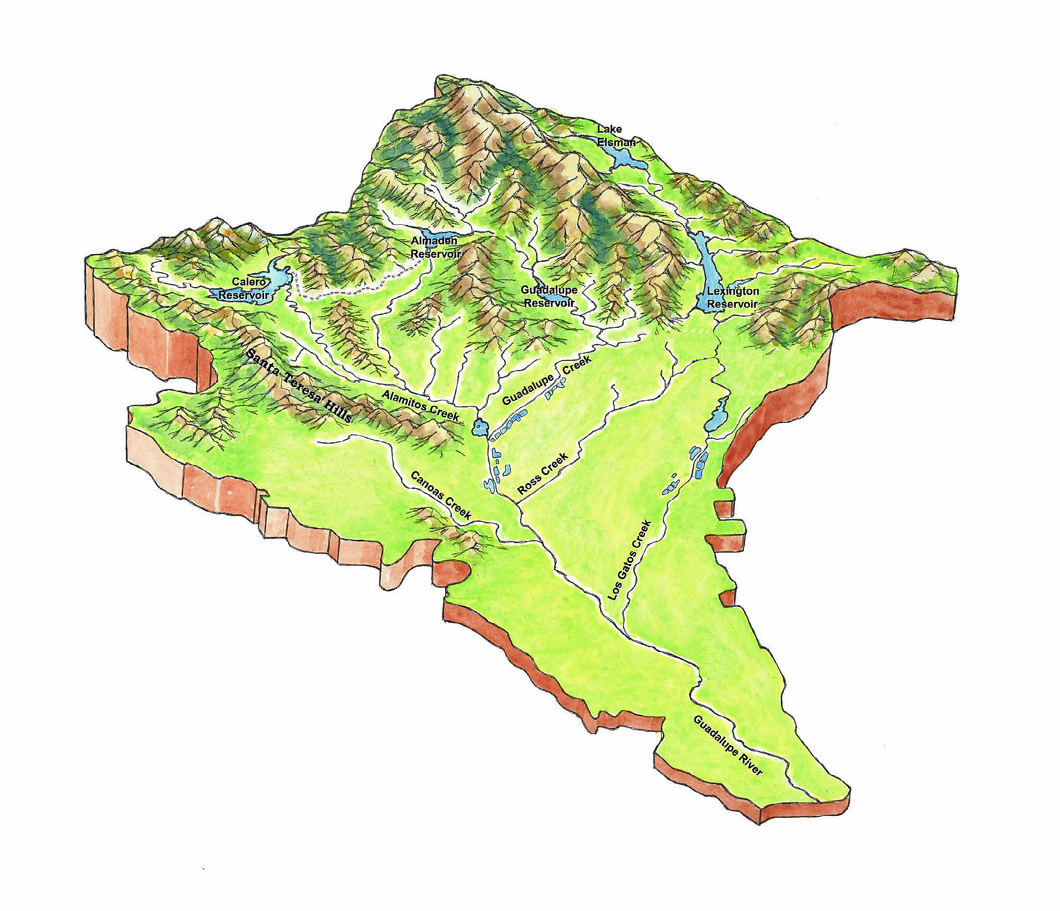
The Guadalupe River ( es, Río Guadalupe; Muwekma Ohlone:''Thámien Rúmmey'') mainstem is an urban, northward flowing river in California whose much longer headwater creeks originate in the Santa Cruz Mountains. The river mainstem now begins on the Santa Clara Valley floor when Los Alamitos Creek exits Lake Almaden and joins Guadalupe Creek just downstream of Coleman Road in San Jose, California. From here it flows north through San Jose, where it receives Los Gatos Creek, a major tributary. The Guadalupe River serves as the eastern boundary of the City of Santa Clara and the western boundary of Alviso, and after coursing through San José, it empties into south San Francisco Bay at the Alviso Slough. The Guadalupe River is the southernmost major U.S. river with a Chinook salmon run (see Habitat and Wildlife section below). Much of the river is surrounded by parks. The river's Los Alamitos and Guadalupe Creek tributaries are, in turn, fed by smaller streams flowing from Alm ... [...More Info...] [...Related Items...] OR: [Wikipedia] [Google] [Baidu] |
Russian River (California)
The Russian River (Southern Pomo: ''Ashokawna'', es, Río Ruso) is a southward-flowing river that drains of Sonoma and Mendocino counties in Northern California. With an annual average discharge of approximately 1,600,000 acre feet (2.0 km3), it is the second-largest river (after the Sacramento River) flowing through the nine-county Greater San Francisco Bay Area, with a mainstem long. Names The Southern Pomo know the river as Ashokawna (ʼaš:oʼkʰawna), "east water place" or "water to the east", and as Bidapte, "big river". Juan Rodríguez Cabrillo and his expedition may have travelled as far north as the Russian River in November 1542 before storms forced them to turn back south towards Monterey. The earliest Slavic name for the river, Slavyanka, appears on a Russian-American Company chart dated 1817. In 1827 the Spanish called it the San Ygnacio, and in 1843 the Spanish land grant referred to it as Rio Grande. The river takes its current name from Russian Iv ... [...More Info...] [...Related Items...] OR: [Wikipedia] [Google] [Baidu] |


_nahe_dem_Weiherdamm_in_Wildbergerhütte.jpg)


