|
Halloween Blizzard
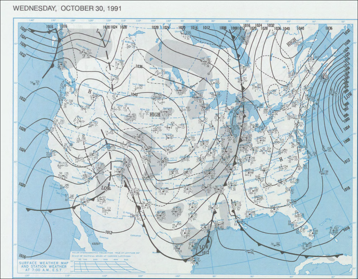
The 1991 Halloween blizzard was a powerful storm that caused a period of heavy snowfall and ice accumulation, which affected parts of the Upper Midwest of the United States, from October 31 to November 3, 1991. Over the last week of October 1991, a large storm system over the Atlantic Ocean (1991 Perfect Storm) blocked most of the weather patterns over the eastern half of the United States, and in turn, moisture from the Gulf of Mexico was funneled straight northward over the affected region. By the time the precipitation stopped falling, many cities in the eastern half of Minnesota and northwestern Wisconsin had witnessed record early-season snowfall accumulations, while parts of southern Minnesota and northern Iowa were crippled by a large ice storm. Arctic air that was pulled southward behind the storm had combined with the heavy snow pack to produce many record low temperatures. Between the blizzard and the ice storm, 22 people were killed and over 100 were injured. Meteorol ... [...More Info...] [...Related Items...] OR: [Wikipedia] [Google] [Baidu] |
1991 Perfect Storm
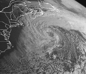
The 1991 Perfect Storm, also known as The No-Name Storm (especially in the years immediately after it took place) and the Halloween Gale/Storm, was a nor'easter that absorbed Hurricane Grace, and ultimately evolved into a small unnamed hurricane itself late in its life cycle. The initial area of low pressure developed off the coast of Atlantic Canada on October 28. Forced southward by a ridge to its north, it reached its peak intensity as a large and powerful cyclone. The storm lashed the east coast of the United States with high waves and coastal flooding before turning to the southwest and weakening. Moving over warmer waters, the system transitioned into a subtropical cyclone before becoming a tropical storm. It executed a loop off the Mid-Atlantic states and turned toward the northeast. On November 1, the system evolved into a full-fledged hurricane, with peak sustained winds of 75 miles per hour (120 km/h), although the National Hurricane Center left it unnamed to avoi ... [...More Info...] [...Related Items...] OR: [Wikipedia] [Google] [Baidu] |
Arctic
The Arctic ( or ) is a polar regions of Earth, polar region located at the northernmost part of Earth. The Arctic consists of the Arctic Ocean, adjacent seas, and parts of Canada (Yukon, Northwest Territories, Nunavut), Danish Realm (Greenland), Finland, Iceland, Norway, Russia (Murmansk Oblast, Murmansk, Siberia, Nenets Autonomous Okrug, Nenets Okrug, Novaya Zemlya), Sweden and the United States (Alaska). Land within the Arctic region has seasonally varying snow and sea ice, ice cover, with predominantly treeless permafrost (permanently frozen underground ice) containing tundra. Arctic seas contain seasonal sea ice in many places. The Arctic region is a unique area among Earth's ecosystems. The cultures in the region and the Arctic indigenous peoples have adapted to its cold and extreme conditions. Life in the Arctic includes zooplankton and phytoplankton, fish and marine mammals, birds, land animals, plants and human societies. Arctic land is bordered by the subarctic. De ... [...More Info...] [...Related Items...] OR: [Wikipedia] [Google] [Baidu] |
Low-pressure Area (meteorology)
In meteorology, a low-pressure area, low area or low is a region where the atmospheric pressure is lower than that of surrounding locations. Low-pressure areas are commonly associated with inclement weather (such as cloudy, windy, with possible rain or storms), while high-pressure areas are associated with lighter winds and clear skies. Winds circle anti-clockwise around lows in the northern hemisphere, and clockwise in the southern hemisphere, due to opposing Coriolis forces. Low-pressure systems form under areas of wind divergence that occur in the upper levels of the atmosphere (aloft). The formation process of a low-pressure area is known as cyclogenesis. In meteorology, atmospheric divergence aloft occurs in two kinds of places: * The first is in the area on the east side of upper troughs, which form half of a Rossby wave within the Westerlies (a trough with large wavelength that extends through the troposphere). * A second is an area where wind divergence aloft occurs a ... [...More Info...] [...Related Items...] OR: [Wikipedia] [Google] [Baidu] |
South Central United States
The South Central United States or South Central states is a region in the south central portion of the Southern United States. It evolved out of the Old Southwest, which originally was the western portion of the South. The states of Arkansas, Louisiana, Oklahoma, and Texas (which make up what the Census Bureau Division calls West South Central States) are almost always considered the "core" of the region. As part of the East South Central States sub-group of the Census Bureau classification, Alabama, Mississippi, Tennessee and Kentucky are also frequently listed under the heading. At the highest extent, Kansas, and Missouri, may be included by some sources. If defined as only its four core states, the region lies almost exclusively in the Central Time Zone (with El Paso being the only major city to observe Mountain Time). At different times, all of the above states were considered part of the Western United States in American history. History The history of the South Centr ... [...More Info...] [...Related Items...] OR: [Wikipedia] [Google] [Baidu] |
Shortwave (meteorology)
A shortwave or shortwave trough is an embedded kink in the trough / ridge pattern. Its length scale is much smaller than that of and is embedded within longwaves, which are responsible for the largest scale (synoptic scale) weather systems. Shortwaves may be contained within or found ahead of longwaves and range from the mesoscale to the synoptic scale. Shortwaves are most frequently caused by either a cold pool or an upper level front. Shortwaves are commonly referred to as a vorticity maximum. Corresponding weather and effects Shortwaves are often associated with warm air advection (WAA) or cold air advection (CAA), which influence temperature. Due to the way they move the air around them and the way air moves away from them, shortwaves produce positive curvature vorticity and positive shear vorticity, respectively. Ahead of a shortwave there is large-scale lift due to divergence from positive vorticity advection (PVA). This lift often causes precipitation. In a capped ... [...More Info...] [...Related Items...] OR: [Wikipedia] [Google] [Baidu] |
1991 Halloween Low Track
File:1991 Events Collage.png, From left, clockwise: Boris Yeltsin, elected as Russia's first president, waves the new flag of Russia after the 1991 Soviet coup d'état attempt, orchestrated by Soviet hardliners; Mount Pinatubo erupts in the Philippines, making it the second-largest volcanic eruption of the 20th century; MTS Oceanos sinks off the coast of South Africa, but the crew notoriously abandons the vessel before the passengers are rescued; Dissolution of the Soviet Union: The Soviet flag is lowered from the Kremlin for the last time and replaced with the flag of the Russian Federation; The United States and soon-to-be dissolved Soviet Union sign the START I Treaty; A tropical cyclone strikes Bangladesh, killing nearly 140,000 people; Lauda Air Flight 004 crashes after one of its thrust reversers activates during the flight; A United States-led coalition initiates Operation Desert Storm to remove Iraq and Saddam Hussein from Kuwait, 300x300px, thumb rect 0 0 200 200 1991 S ... [...More Info...] [...Related Items...] OR: [Wikipedia] [Google] [Baidu] |
South Dakota
South Dakota (; Sioux language, Sioux: , ) is a U.S. state in the West North Central states, North Central region of the United States. It is also part of the Great Plains. South Dakota is named after the Lakota people, Lakota and Dakota people, Dakota Sioux Native Americans in the United States, Native American tribes, who comprise a large portion of the population with nine Indian reservation, reservations currently in the state and have historically dominated the territory. South Dakota is the List of U.S. states and territories by area, seventeenth largest by area, but the List of U.S. states and territories by population, 5th least populous, and the List of U.S. states and territories by population density, 5th least densely populated of the List of U.S. states, 50 United States. As the southern part of the former Dakota Territory, South Dakota became a state on November 2, 1889, simultaneously with North Dakota. They are the 39th and 40th states admitted to the union; Pr ... [...More Info...] [...Related Items...] OR: [Wikipedia] [Google] [Baidu] |
North Dakota
North Dakota () is a U.S. state in the Upper Midwest, named after the Native Americans in the United States, indigenous Dakota people, Dakota Sioux. North Dakota is bordered by the Canadian provinces of Saskatchewan and Manitoba to the north and by the U.S. states of Minnesota to the east, South Dakota to the south, and Montana to the west. It is believed to host the geographic center of North America, Rugby, North Dakota, Rugby, and is home to the tallest man-made structure in the Western Hemisphere, the KVLY-TV mast. North Dakota is the List of U.S. states and territories by area, 19th largest state, but with a population of less than 780,000 2020 United States census, as of 2020, it is the List of U.S. states and territories by population, 4th least populous and List of U.S. states by population density, 4th most sparsely populated. The capital is Bismarck, North Dakota, Bismarck while the largest city is Fargo, North Dakota, Fargo, which accounts for nearly a fifth of the s ... [...More Info...] [...Related Items...] OR: [Wikipedia] [Google] [Baidu] |
Amarillo, Texas
Amarillo ( ; Spanish for "yellow") is a city in the U.S. state of Texas and the seat of Potter County. It is the 14th-most populous city in Texas and the largest city in the Texas Panhandle. A portion of the city extends into Randall County. The estimated population of Amarillo was 200,393 as of April 1, 2020. The Amarillo- Pampa-Borger combined statistical area had an estimated population of 308,297 as of 2020. The city of Amarillo, originally named Oneida, is situated in the Llano Estacado region.Rathjen, Fredrick W. ''The Texas Panhandle Frontier'' (1973). pg. 11. The University of Texas Press. . The availability of the railroad and freight service provided by the Fort Worth and Denver City Railroad contributed to the city's growth as a cattle-marketing center in the late 19th century.. Retrieved on January 25, 2007. Amarillo was once the self-proclaimed "Helium Capital of the World" for having one of the country's most productive helium fields. The city is also known ... [...More Info...] [...Related Items...] OR: [Wikipedia] [Google] [Baidu] |
Wyoming
Wyoming () is a U.S. state, state in the Mountain states, Mountain West subregion of the Western United States. It is bordered by Montana to the north and northwest, South Dakota and Nebraska to the east, Idaho to the west, Utah to the southwest, and Colorado to the south. With a population of 576,851 in the 2020 United States census, Wyoming is the List of U.S. states and territories by population, least populous state despite being the List of U.S. states and territories by area, 10th largest by area, with the List of U.S. states by population density, second-lowest population density after Alaska. The state capital and List of municipalities in Wyoming, most populous city is Cheyenne, Wyoming, Cheyenne, which had an estimated population of 63,957 in 2018. Wyoming's western half is covered mostly by the ranges and rangelands of the Rocky Mountains, while the eastern half of the state is high-elevation prairie called the High Plains (United States), High Plains. It is drier ... [...More Info...] [...Related Items...] OR: [Wikipedia] [Google] [Baidu] |
Montana
Montana () is a state in the Mountain West division of the Western United States. It is bordered by Idaho to the west, North Dakota and South Dakota to the east, Wyoming to the south, and the Canadian provinces of Alberta, British Columbia, and Saskatchewan to the north. It is the fourth-largest state by area, the eighth-least populous state, and the third-least densely populated state. Its state capital is Helena. The western half of Montana contains numerous mountain ranges, while the eastern half is characterized by western prairie terrain and badlands, with smaller mountain ranges found throughout the state. Montana has no official nickname but several unofficial ones, most notably "Big Sky Country", "The Treasure State", "Land of the Shining Mountains", and " The Last Best Place". The economy is primarily based on agriculture, including ranching and cereal grain farming. Other significant economic resources include oil, gas, coal, mining, and lumber. The health ca ... [...More Info...] [...Related Items...] OR: [Wikipedia] [Google] [Baidu] |
Fahrenheit
The Fahrenheit scale () is a temperature scale based on one proposed in 1724 by the physicist Daniel Gabriel Fahrenheit (1686–1736). It uses the degree Fahrenheit (symbol: °F) as the unit. Several accounts of how he originally defined his scale exist, but the original paper suggests the lower defining point, 0 °F, was established as the freezing temperature of a solution of brine made from a mixture of water, ice, and ammonium chloride (a salt). The other limit established was his best estimate of the average human body temperature, originally set at 90 °F, then 96 °F (about 2.6 °F less than the modern value due to a later redefinition of the scale). For much of the 20th century, the Fahrenheit scale was defined by two fixed points with a 180 °F separation: the temperature at which pure water freezes was defined as 32 °F and the boiling point of water was defined to be 212 °F, both at sea level and under standard atmospheric pressure. ... [...More Info...] [...Related Items...] OR: [Wikipedia] [Google] [Baidu] |


