|
Gäu Plateaus
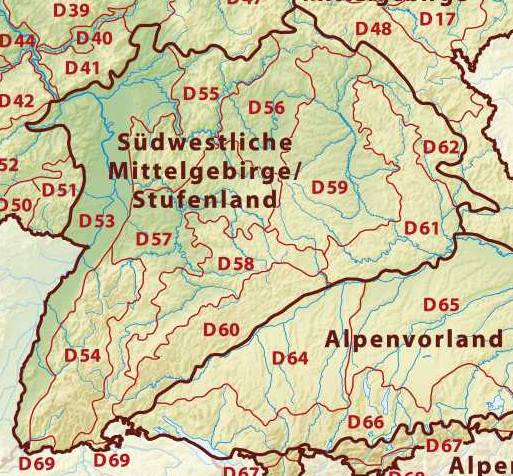
The Gäu PlateausElkins, T.H. (1972). ''Germany'' (3rd ed.). London: Chatto & Windus, 1972, pp 186-188. ASIN B0011Z9KJA. (german: Neckar- und Taubergäuplatten) form the largest natural region in the German state of Baden-Württemberg. Not surprisingly, the individual geographical units of this large region show considerable variations in climate and soil types. A common feature of the region, however, is its landscape of flat-topped hills of Muschelkalk, gently rolling tracts of loess and plateaus in which the layers of Muschelkalk have been covered by sediments of Gipskeuper and Lettenkeuper. The Gäu Plateaus are the northwestern part of the Southern Scarplands. Location and geology The Gäu Plateaus extend from the Upper Rhine to the Tauber valley. They are bordered to the west by the Black Forest and the Upper Rhine Plain, to the north by the Odenwald and the Mainfranken Plateaus, to the east by the Franconian and Swabian Keuper-Lias Lands and the Swabian Jura. ... [...More Info...] [...Related Items...] OR: [Wikipedia] [Google] [Baidu] |
Central Uplands
The Central UplandsDickinson (1964), p.18 ff. (german: die MittelgebirgeN.B. In German die ''Mittelgebirge'' (plural) refers to the Central Uplands; das ''Mittelgebirge'' refers to a low mountain range or upland region (''Mittel'' = "medium" and ''-gebirge'' = "range").) is one of the three major natural regions of Germany. It stretches east to west across the country. To the north lies the North German Plain or Northern Lowland; to the south, the Alps and the Alpine Foreland. Formation The German Central Uplands, like the Scandinavian and British mountain ranges and the Urals, belong to the oldest mountains of Europe, even if their present-day appearance has only developed relatively recently. In the Carboniferous, i.e. about 350 million years ago, Variscan mountain ranges were formed in central Europe by the uplifting caused by tectonic plate collision. Immediately after their formation the erosion of the mountains began under the influence of exogenous processes during the ... [...More Info...] [...Related Items...] OR: [Wikipedia] [Google] [Baidu] |
Bundesamt Für Naturschutz
The German Federal Agency for Nature Conservation (german: Bundesamt für Naturschutz, ''BfN'') is the German government's scientific authority with responsibility for national and international nature conservation. BfN is one of the government's departmental research agencies and reports to the German Environment Ministry (BMU). The Agency provides the German Environment Ministry with professional and scientific assistance in all nature conservation and land management issues and in international cooperation activities. BfN furthers its objectives by carrying out related scientific research and is also in charge of a number of funding programmes. BfN additionally performs important enforcement work under international agreements on species conservation and nature conservation, the Antarctic Treaty, and the German Genetic Engineering Act. Application areas of BfN The diversity of species, habitats and landscapes is critical to human survival. Safeguarding this diversity for the ... [...More Info...] [...Related Items...] OR: [Wikipedia] [Google] [Baidu] |
Bauland
The Bauland is a Gäu landscape in the northeast of the German state of Baden-Württemberg. It is a natural region within the Neckar and Tauber Gäu Plateaus (major unit 12) in the South German Scarplands. Location The Bauland is a Gäu landscape in the northeast of the German state of Baden-Württemberg. It is a natural region within the Neckar and Tauber Gäu Plateaus (major unit 12) in the South German Scarplands. It lies between the Odenwald forest and the Tauber, Jagst and Neckar rivers within the counties of Main-Tauber-Kreis and Neckar-Odenwald-Kreis. It also reaches into Hohenlohekreis and the county of Heilbronn. The Bauland is no. 128 in the classification system of the '' Handbook of Natural Region Divisions of Germany''. Etymology The name ''Bauland'' goes back to the word ''Ponland'' which meant a "strip of land in which beans are cultivated" (from the Middle High German ''pône''). The Bauland is colloquially known as Baden Siberia (''Badisch Sibirien' ... [...More Info...] [...Related Items...] OR: [Wikipedia] [Google] [Baidu] |
Haller Ebene
The Haller Ebene is a plain in the German state of Baden-Württemberg which forms part of the Hohenlohe Plain and stretches from Bad Mergentheim via Rothenburg, Uffenheim, Crailsheim, Öhringen as far as Schwäbisch Hall Schwäbisch Hall (; "Swabian Hall"; from 1802 until 1934 and colloquially: ''Hall'' ) is a city in the German state of Baden-Württemberg located in the valley of the Kocher river, the longest tributary (together with its headwater Lein) of the .... The Haller Ebene specifically refers to that region of the Hohenloher Ebene around the town of Schwäbisch Hall. Natural regions of Germany Regions of Baden-Württemberg Natural regions of the Neckar and Tauber Gäu Plateaus {{BadenWürttemberg-geo-stub ... [...More Info...] [...Related Items...] OR: [Wikipedia] [Google] [Baidu] |
Jagst
The Jagst () is a right tributary of the Neckar in northern Baden-Württemberg. It is 190 km long. Its source is in the hills east of Ellwangen, close to the Bavarian border. It winds through the towns Ellwangen, Crailsheim, Kirchberg an der Jagst, Langenburg, Krautheim, Möckmühl and Neudenau. Near Bad Wimpfen the Jagst flows into the Neckar, a few km downstream from the mouth of the river Kocher, that flows more or less parallel to the Jagst. To the south of the river is the Harthausen Forest. Tributaries The following rivers are tributaries to the river Jagst (from source to mouth): *Left: Rotenbach, Orrot, Klingenbach, Steinbach, Speltach, Maulach, Grundbach, Ginsbach, Sindelbach *Right: Röhlinger Sechta, Rechenberger Rot (Rotbach), Reiglersbach, Gronach, Brettach, Rötelbach, Ette, Erlenbach, Kessach, Hergstbach, Seckach, Schefflenz, Tiefenbach See also * List of rivers of Baden-Württemberg A list of rivers of Baden-Württemberg, Germany: A * ... [...More Info...] [...Related Items...] OR: [Wikipedia] [Google] [Baidu] |
Kocher
The Kocher () is a -longincluding its source river Schwarzer Kocher right tributary of the Neckar in the north-eastern part of Baden-Württemberg, Germany. The name "Kocher" originates from its Celtic name "cochan" and probably means winding, meandering river. Its total drainage area is . The Kocher rises in the eastern foothills of the Swabian Alb from two karst springs, the Schwarzer (black) Kocher and the Weißer (white) Kocher, that join in Unterkochen near Aalen. The Schwarzer Kocher is approximately long. Its source discharge varies between 50 L/s and 4,000 L/s with an average of 680 L/s. The long Weißer Kocher has an average discharge of 400 L/s. Course The Schwarzer Kocher rises south of Oberkochen. The second source, the Weißer Kocher rises west of Unterkochen from many small sources. The name Weißer Kocher comes from the white foam on the water when it quickly rushes over the stones. In contrast, the Schwarzer Kocher flows rather slowly and the covered ground ... [...More Info...] [...Related Items...] OR: [Wikipedia] [Google] [Baidu] |
Kraichgau
The Kraichgau () is a hilly region in Baden-Württemberg, southwestern Germany. It is bordered by the Odenwald and the Neckar to the North, the Black Forest to the South, and the Upper Rhine Plain to the West. To the east, its boundary is considered to be the Stromberg and the Heuchelberg. The largest towns of the Kraichgau are Sinsheim, Eppingen, and Bretten. On the western end of the Kraichgau is the town of Bruchsal, the gateway to the Rhineland plains. Origins of the name The word "Kraich" apparently arose from the Celtic word "Creuch," meaning "mud" or "loam." The territory of a Gau (country subdivision) signifies an open area, free from woods, such as farmland or meadows. The area of Kraichgau was first mentioned in the Early Middle Ages, in the Lorsch codex, as "Creichgowe" in the year 769. In 773, it was called "Chrehgauui," in 778 "Craichgoia." By 1594, the name was closer to its modern form, being referred to as "Kreuchgau." See also *Aalkistensee Aalk ... [...More Info...] [...Related Items...] OR: [Wikipedia] [Google] [Baidu] |
Heuchelberg
The Heuchelberg is a hill ridge, about 15 kilometres long and up to , a few kilometres southwest of the city of Heilbronn in the eponymous county in the German state of Baden-Württemberg. Location The Heuchelberg and the adjacent Stromberg region south of the River Zaber both give their names to the Stromberg-Heuchelberg Nature Park founded in 1980, the third nature park in Baden-Württemberg. The Heuchelberg runs through the western part of the county of Heilbronn between Leingarten in the northeast and Zaberfeld in the southwest. It lies on the territories of the following towns and villages (clockwise from the northeast): Leingarten, Nordheim, Brackenheim, Güglingen, Pfaffenhofen and Zaberfeld (in the southwest) and Eppingen (only the municipality of Kleingartach), Schwaigern and finally Leingarten again. Hills The hills and high points of the Heuchelberg ridge include the following − sorted by height in metres above Normalnull (NN): [...More Info...] [...Related Items...] OR: [Wikipedia] [Google] [Baidu] |
Stromberg (region)
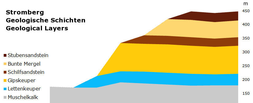
The Stromberg is a heavily forested hill ridge up to in the northern part of the German state of Baden-Württemberg. [Baidu] |


