|
Gvoko
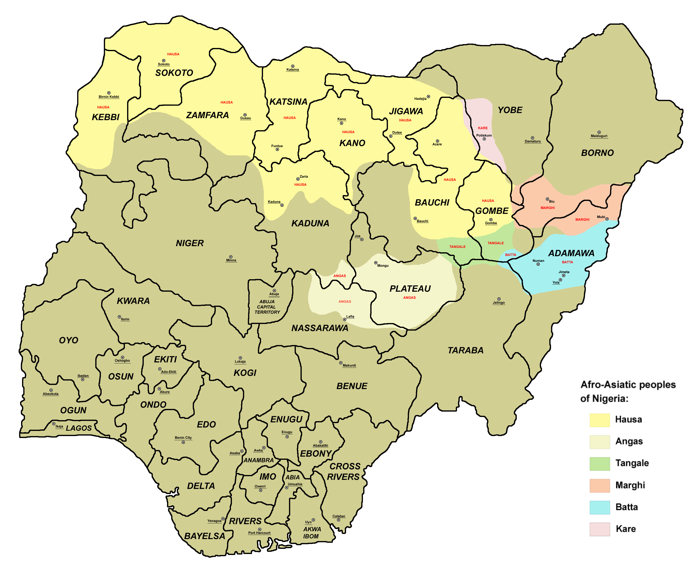
Gvoko (also known as Gevoko, Ghboko, Gavoko, Kuvoko, Ngossi, Ngoshi, Ngoshe-Ndhang, Ngweshe-Ndaghan, Ngoshe Sama, Nggweshe) is an Afro-Asiatic language spoken in Borno State Borno State is a state in the North-East geopolitical zone of Nigeria, bordered by Yobe to the west, Gombe to the southwest, and Adamawa to the south while its eastern border forms part of the national border with Cameroon, its northern border ..., Nigeria and Far North Province, Cameroon. In Cameroon, Gevoko is spoken in the village of Ngossi, on the border with Nigeria, north of Tourou ( Mokolo arrondissement, Mayo-Tsanaga department). It is mainly spoken in Nigeria. References Biu-Mandara languages Languages of Nigeria Languages of Cameroon {{Cameroon-stub ... [...More Info...] [...Related Items...] OR: [Wikipedia] [Google] [Baidu] |
Biu–Mandara Languages
The Biu–Mandara or Central Chadic languages of the Afro-Asiatic family are spoken in Nigeria, Chad and Cameroon. A reconstruction of Proto-Central Chadic has been proposed by Gravina (2014). Languages Gravina (2014) Gravina (2014) classifies Central Chadic as follows, as part of a reconstruction of the proto-language. Letters and numbers in parentheses correspond to branches in previous classifications. The greatest changes are breaking up and reassigning the languages of the old Mafa branch (A.5) and Mandage (Kotoko) branch (B.1). *South **South ***Bata (A.8) ****Bata Proper: Bacama, Bata, Fali, Gude, Gudu, Holma (†), Jimi, Ngwaba (from A.1 Tera), Nzanyi, Sharwa ****Tsuvan: Tsuvan, Zizilivakan ***Daba (A.7) ****Daba Proper: Daba, Mazagway Hidi ****Mina: Mina, Mbudum ****Buwal: Buwal, Gavar ***Mafa (= South A.5 Mafa (d)): Mafa, Mefele, Cuvok ***Tera (A.1): ****East Tera: Boga, Ga'anda, Hwana ****(West Tera): Jara, Tera *** Sukur (A.6) *Hurza **Hurza (fr ... [...More Info...] [...Related Items...] OR: [Wikipedia] [Google] [Baidu] |
Borno State
Borno State is a state in the North-East geopolitical zone of Nigeria, bordered by Yobe to the west, Gombe to the southwest, and Adamawa to the south while its eastern border forms part of the national border with Cameroon, its northern border forms part of the national border with Niger, and its northeastern border forms all of the national border with Chad, being the only Nigerian state to border three foreign countries. It takes its name from the historic emirate of Borno, with the emirate's old capital of Maiduguri serving as the capital city of Borno State. The state was formed in 1976 when the former North-Eastern State was broken up. It originally included the area that is now Yobe State, which became a distinct state in 1991. Borno is the second largest in area of the 36 states, only behind Niger State. Despite its size, the state is the eleventh most populous with an estimated population of about 5.86 million as of 2016. Geographically, the state is divided betw ... [...More Info...] [...Related Items...] OR: [Wikipedia] [Google] [Baidu] |
Far North Province
The Far North Region, also known as the Extreme North Region (from french: Région de l'Extrême-Nord), is the northernmost constituent province of the Republic of Cameroon. It borders the North Region to the south, Chad to the east, and Nigeria to the west. The capital is Maroua. The province is one of Cameroon's most culturally diverse. Over 50 different ethnic groups populate the area, including the Shuwa Arabs, Fulani, and Kapsiki. Most inhabitants speak the Fulani language Fulfulde, Chadian Arabic, and French. Geography Land Sedimentary rock such as alluvium, clay, limestone, and sandstone forms the greatest share of the Far North's geology. These deposits follow the province's rivers, such as the Logone and Mayo Tsanaga, as they empty into Lake Chad to the north. At the province's south, a band of granite separates the sedimentary area from a zone of metamorphic rock to the southwest. This latter region includes deposits of gneiss, mica, and schists. The Rhumsiki V ... [...More Info...] [...Related Items...] OR: [Wikipedia] [Google] [Baidu] |
Nigeria
Nigeria ( ), , ig, Naìjíríyà, yo, Nàìjíríà, pcm, Naijá , ff, Naajeeriya, kcg, Naijeriya officially the Federal Republic of Nigeria, is a country in West Africa. It is situated between the Sahel to the north and the Gulf of Guinea to the south in the Atlantic Ocean. It covers an area of , and with a population of over 225 million, it is the most populous country in Africa, and the world's sixth-most populous country. Nigeria borders Niger in the north, Chad in the northeast, Cameroon in the east, and Benin in the west. Nigeria is a federal republic comprising of 36 states and the Federal Capital Territory, where the capital, Abuja, is located. The largest city in Nigeria is Lagos, one of the largest metropolitan areas in the world and the second-largest in Africa. Nigeria has been home to several indigenous pre-colonial states and kingdoms since the second millennium BC, with the Nok civilization in the 15th century BC, marking the first ... [...More Info...] [...Related Items...] OR: [Wikipedia] [Google] [Baidu] |
Cameroon
Cameroon (; french: Cameroun, ff, Kamerun), officially the Republic of Cameroon (french: République du Cameroun, links=no), is a country in west-central Africa. It is bordered by Nigeria to the west and north; Chad to the northeast; the Central African Republic to the east; and Equatorial Guinea, Gabon and the Republic of the Congo to the south. Its coastline lies on the Bight of Biafra, part of the Gulf of Guinea and the Atlantic Ocean. Due to its strategic position at the crossroads between West Africa and Central Africa, it has been categorized as being in both camps. Its nearly 27 million people speak 250 native languages. Early inhabitants of the territory included the Sao civilisation around Lake Chad, and the Baka hunter-gatherers in the southeastern rainforest. Portuguese explorers reached the coast in the 15th century and named the area ''Rio dos Camarões'' (''Shrimp River''), which became ''Cameroon'' in English. Fulani soldiers founded the Adamawa Emirate ... [...More Info...] [...Related Items...] OR: [Wikipedia] [Google] [Baidu] |
Chadic Languages
The Chadic languages form a branch of the Afroasiatic language family. They are spoken in parts of the Sahel. They include 150 languages spoken across northern Nigeria, southern Niger, southern Chad, the Central African Republic, and northern Cameroon. The most widely spoken Chadic language is Hausa, a ''lingua franca'' of much of inland Eastern West Africa. Composition Paul Newman (1977) classified the languages into the four groups which have been accepted in all subsequent literature. Further subbranching, however, has not been as robust; Roger Blench(2006), for example, only accepts the A/B bifurcation of East Chadic. Kujargé has been added from Blench (2008), who suggests Kujargé may have split off before the breakup of Proto-Chadic and then subsequently became influenced by East Chadic. Subsequent work by Joseph Lovestrand argues strongly that Kujarge is a valid member of East Chadic. The placing of Luri as a primary split of West Chadic is erroneous. Bernard Caron (200 ... [...More Info...] [...Related Items...] OR: [Wikipedia] [Google] [Baidu] |
Wandala Languages
The Mandara Kingdom (sometimes called Wandala) was an African kingdom in the Mandara Mountains of what is today Cameroon. The Mandara people are descended from the kingdom's inhabitants. History Tradition states that Mandara was founded shortly before 1500 by a female ruler named ''Soukda'' and a non-Mandarawa hunter named ''Gaya''. The kingdom was first referred to by Fra Mauro (in 1459) and Leo Africanus (in 1526); the provenance of its name remains uncertain. For the kingdom's first century of history, its rulers warred with neighbouring groups in an effort to expand their territories. After conquering the Dulo (or Duolo) and establishing the capital at Dulo c. 1580, the dynasty of Sankre, a war leader, began. When the Dulo made an attempt to seize the throne, the Bornu kingdom supported the claim of Aldawa Nanda, a member of Sankre's house. Emperor Idris Alaoma of Borno personally installed Nanda as king in 1614. Bornu thus attained an influential position over Manda ... [...More Info...] [...Related Items...] OR: [Wikipedia] [Google] [Baidu] |
Afro-Asiatic Languages
The Afroasiatic languages (or Afro-Asiatic), also known as Hamito-Semitic, or Semito-Hamitic, and sometimes also as Afrasian, Erythraean or Lisramic, are a language family of about 300 languages that are spoken predominantly in the geographic subregions of Western Asia, North Africa, the Horn of Africa, and parts of the Sahara/Sahel. With the exception of its Semitic branch, all branches of the Afroasiatic family are exclusively native to the African continent. Afroasiatic languages have over 500 million native speakers, which is the fourth-largest number of native speakers of any language family (after Indo-European, Sino-Tibetan, and Niger–Congo). The phylum has six branches: Berber languages, Berber, Chadic languages, Chadic, Cushitic languages, Cushitic, Egyptian language, Egyptian, Semitic languages, Semitic, and Omotic languages, Omotic. The most widely spoken modern Afroasiatic language or dialect continuum by far is Arabic, a ''de facto'' group of Varieties of Arabi ... [...More Info...] [...Related Items...] OR: [Wikipedia] [Google] [Baidu] |
Tourou
Tourou is a village in the commune of Parakou in the Borgou Department of central-eastern Benin. It is located west of Parakou city centre on the RNIE 6 RNIE 6 is a national highway of Benin located in the east of the country. Cities and towns * Nikki * Pèrèrè *Parakou Parakou is the largest city in northern Benin, with an estimated population of around 206,667 people, and capital of the ... highway. External linksSatellite map at Maplandia Populated places in the Borgou Department Commune of Parakou {{BorgouDepartment-geo-stub ... [...More Info...] [...Related Items...] OR: [Wikipedia] [Google] [Baidu] |
Mokolo
Mokolo is the departmental capital and largest city of the Mayo-Tsanaga department, in the Far North Province of Cameroon. It is the fourth largest city in the Far North Province, after Maroua, Yagoua, and Kousséri. It is located in the Mandara Mountains that run along the Cameroonian-Nigerian border. History and Culture Fulbé (also known as Fulani) and Mafa peoples dominate the Mokolo area. Historically, the Mafa were the original inhabitants. When the Fulbé came through the area, many of the Mafa dispersed into the surrounding Mandara Mountains. The Mafa are also known as the Matakam, a name given by the Fulbé, meaning “well-dressed.” In 1916 Mokolo was subordinate to Madagali, a Nigerian town, and was ruled from there. Mokolo was centrally located along a well-traveled trade route. The Guiziga and Fulbé peoples living near Maroua traded salt and natron with the Mafa living further West, who provided red earth and herbs, used for dyeing cloth. In roughly 1947 the ... [...More Info...] [...Related Items...] OR: [Wikipedia] [Google] [Baidu] |
Mayo-Tsanaga
Mayo-Tsanaga is a department of Extreme-Nord Province in Cameroon. The department covers an area of 4,393 km and at the 2005 Census had a total population of 699,971. The capital of the department is at Mokolo. It is located within the Mandara Mountains, on the border with Nigeria. Subdivisions The department is divided administratively into 7 communes and in turn into villages. Communes * Bourrha * Hina * Koza * Mogodé * Mokolo Mokolo is the departmental capital and largest city of the Mayo-Tsanaga department, in the Far North Province of Cameroon. It is the fourth largest city in the Far North Province, after Maroua, Yagoua, and Kousséri. It is located in the Manda ... * Mozogo * Souledé-Roua Gallery File:Mandara Mountains - panoramio (1).jpg, Mandara Mountains File:Mandara Mountains - panoramio (2).jpg, Mandara Mountains File:Mandara Mountains - panoramio.jpg, Mandara Mountains References Departments of Cameroon Far North Region (Cameroon) ... [...More Info...] [...Related Items...] OR: [Wikipedia] [Google] [Baidu] |


