|
Gushanabad Division
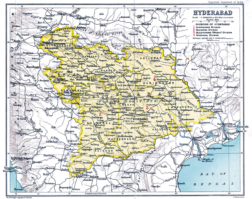
Medak Gulshanabad Division was administratively part of the Hyderabad State Hyderabad State () was a princely state located in the south-central Deccan region of India with its capital at the city of Hyderabad. It is now divided into the present-day state of Telangana, the Kalyana-Karnataka region of Karnataka, and t ... was made up of sixteen districts. Gulshanabad was one of four divisions which included Mahbubnagar district, Medak district, Nalgonda district (Nalgundah), and Nizamabad district. History Medak Gulshanabad Division was part of Bidar division, and was formed in 1905. Districts * Mahbubnagar district * Medak district * Nalgonda district (Nalgundah) * Nizamabad district References {{Divisions of British India Hyderabad State ... [...More Info...] [...Related Items...] OR: [Wikipedia] [Google] [Baidu] |
Hyderabad State (1948–56)
Hyderabad State () was a princely state located in the south-central Deccan region of India with its capital at the city of Hyderabad. It is now divided into the present-day state of Telangana, the Kalyana-Karnataka region of Karnataka, and the Marathwada region of Maharashtra in India. The state was ruled from 1724 to 1857 by the Nizam, who was initially a viceroy of the Mughal empire in the Deccan. Hyderabad gradually became the first princely state to come under British paramountcy signing a subsidiary alliance agreement. During British rule in 1901 the state had an average revenue of Rs. 417,000,000, making it the wealthiest princely state in India. The native inhabitants of Hyderabad Deccan, regardless of ethnic origin, are called "Mulki" (countryman), a term still used today. The dynasty declared itself an independent monarchy during the final years of the British Raj. After the Partition of India, Hyderabad signed a standstill agreement with the new dominion of India ... [...More Info...] [...Related Items...] OR: [Wikipedia] [Google] [Baidu] |
Mahbubnagar District
Mahabubnagar district is a district in the Indian state of Telangana. Mahabubnagar is the district headquarters which is popularly known as Palamoor. The district shares boundaries with Narayanapet, Vikarabad, Rangareddy, Nagarkurnool, Wanaparthy and Jogulamba Gadwal districts. The district was formed during the period of the 6th Nizam of Hyderabad State – Nawab Mir Mahbub Ali Khan and hence named after him. Etymology Mahabubnagar was formerly known as ''Palamoor'', meaning "land of milk" due to its milk production. The name was changed to Mahabubnagar on 4 December 1890, in honour of Mir Mahbub Ali Khan Asaf Jah VI, the Nizam of Hyderabad (1869–1911 AD). History The area that forms current Mahabubnagar district has held historic significance. It was under ''Janapada'' rule by 6th century BCE, and later was Maurya territory. The region was at the core of the Satavahana dynasty from 221 BCE to 218 CE, and also a large part of the Chalukya dynasty from the 5th to the ... [...More Info...] [...Related Items...] OR: [Wikipedia] [Google] [Baidu] |
Medak District
Medak district is a district located in the Indian state of Telangana. Medak is the district headquarters. The district shares boundaries with Sangareddy, Kamareddy, Siddipet and Medchal districts. History Traces of Neolithic and Megalithic culture was found at Edithanur and Wargal village hillocks in the district. Rock paintings were found at Edithanur boulders and Hastallapur rocks. Nizam state In 20th century Medak district was a part of Nizam princely State before independence and merged into Hyderabad State in Independent India and presently a district of Telangana. Qutub Shahis named it as Gulshanabad which means '"city of gardens'" due to its luscious greenery. Geography The district is spread over an area of . Demographics As of the 2011 Census of India, the district has a population of 767,428. Economy In 2006 the Indian government named Medak one of the country's 250 most backward districts (out of a total of 640). It is one of the thirteen districts ... [...More Info...] [...Related Items...] OR: [Wikipedia] [Google] [Baidu] |
Nalgonda District
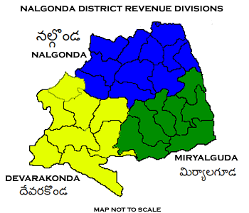
Nalgonda district is a district in the Telangana state of India. Nalgonda district has the highest number of mandals in the state with 31 mandals. The district shares boundaries with Suryapet, Rangareddy, Yadadri and Nagarkurnool districts and with the state boundary of Andhra Pradesh. Etymology Nalgonda is derived from two Telugu words Nalla (Black) & Konda (Hills) i.e. ''Black Hills''. History Nalgonda was earlier referred to as Neelagiri, the name given by some local rulers and the name was changed to ''Nallagonda'' only after its conquest by Allauddin Bahaman Shah, the founder of Bahmani Sultanate . The district had a major role in the Telangana Rebellion. Geography The district is spread over an area of . Demographics Census of India, the district has a population of 1,618,416. According to the 2011 census, 81.75% of the population spoke Telugu, 11.91% Lambadi and 5.51% Urdu as their first language. The Krishna River, Musi River, Aleru, Peddav ... [...More Info...] [...Related Items...] OR: [Wikipedia] [Google] [Baidu] |
Nizamabad District
Nizamabad district is a district located in the north-western region in the Indian state of Telangana. The city of Nizamabad is the district headquarters.It was known as " Indur " which was supposed to have originated from the name of the King was Indradatta who seems to have flourished it during the 5th century A.D.The district share boundaries with Jagtial, Sircilla, Nirmal, Kamareddy districts and with Nanded district of the state boundary of Maharashtra. Etymology ''Nizam'' stands for Nizam, the governor (of the empire) of Hyderabad State and also ''Abad'' means 'Long Live'. Nizamabad was founded in the year 1905 when Nizam's Dominion were it recognized, where up to it was known as ''Indur'' which was supposed to have originated from the name of the King was ''Indradatta'' who seems to have flourished it during the 5th century A.D. Later during the 18th century the Nizams ruled over the Deccan region and the district got its name from him. History In October 2016, the ... [...More Info...] [...Related Items...] OR: [Wikipedia] [Google] [Baidu] |
Hyderabad State From The Imperial Gazetteer Of India, 1909
Hyderabad ( ; , ) is the capital and largest city of the Indian state of Telangana and the ''de jure'' capital of Andhra Pradesh. It occupies on the Deccan Plateau along the banks of the Musi River, in the northern part of Southern India. With an average altitude of , much of Hyderabad is situated on hilly terrain around artificial lakes, including the Hussain Sagar lake, predating the city's founding, in the north of the city centre. According to the 2011 Census of India, Hyderabad is the fourth-most populous city in India with a population of residents within the city limits, and has a population of residents in the metropolitan region, making it the sixth-most populous metropolitan area in India. With an output of 74 billion, Hyderabad has the fifth-largest urban economy in India. Muhammad Quli Qutb Shah established Hyderabad in 1591 to extend the capital beyond the fortified Golconda. In 1687, the city was annexed by the Mughals. In 1724, Asaf Jah I, the Mug ... [...More Info...] [...Related Items...] OR: [Wikipedia] [Google] [Baidu] |


