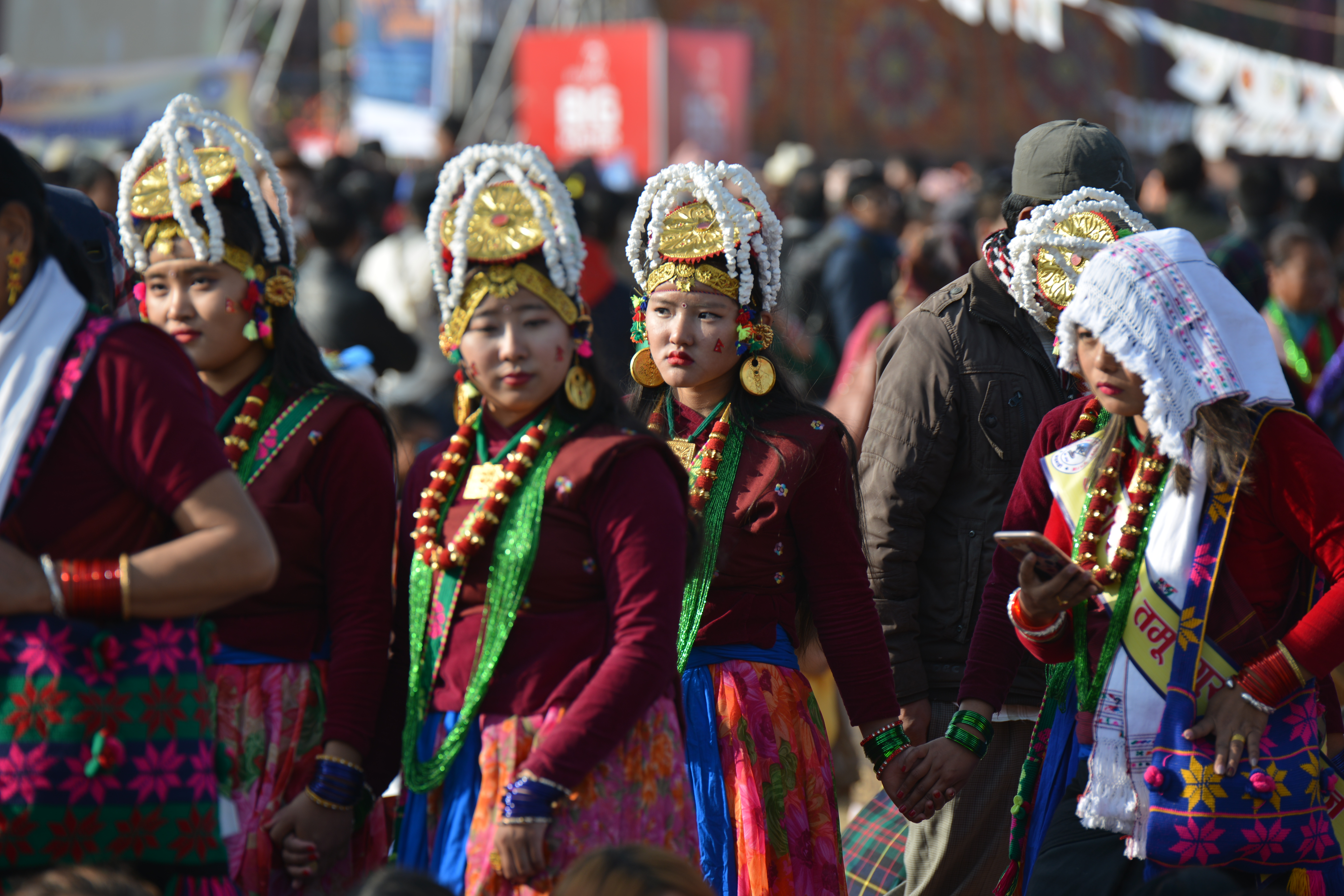
Gurung People
   HOME
*


picture info

Gurung People
Gurung (exonym; ) or Tamu (endonym; Gurung: ) are an ethnic group indigenous to the hills and mountains of Gandaki Province of Nepal. Gurung people predominantly live around the Annapurna region in Manang, Mustang, Dolpo, Kaski, Lamjung, Gorkha, Parbat and Syangja districts of Nepal. They are one of the main Gurkha tribes. They are also scattered across India in Sikkim, Assam, Delhi, West Bengal ( Darjeeling area) and other regions with a predominant Nepali diaspora population. They speak the Sino-Tibetan Gurung language and practice Bon religion alongside Tibetan Buddhism and Hinduism. Gurung caste The Tibetan societies from which the Gurungs came had no caste system and within themselves. Yet for several centuries the Gurungs and other hill peoples have been mixing with the caste cultures of Aryan and they have been influenced by them in various ways. As a result, Gurung caste system has been fragmented into two parts: the four-caste (''Songhi/ Char-jat'') and sixteen-cas ...
[...More Info...]      
[...Related Items...]     OR:     [Wikipedia]   [Google]   [Baidu]  


picture info

Ghatu (dance)
Ghatu dance () is a Nepalese folk dance of the Gurung community of western Nepal. The dance is performed mainly during Baisakh Purnima (full moon day of the Hindu month Baisakh) festival. The dance is started on the previous new moon day of the same month. The dancers are selected on the day of Shree Panchami and then trained for three/four months. Alongside Gurung community, the dance is also performed by people of Magar, Dura, Balami and Kumal communities. Performance In Ghatu dance performance, the story of king Pashramu and queen Yambawati (or Champawati) is presented. Among the two main Ghatu dancers (known as Ghatusari), one plays the role of the king and other plays the role of the queen. King Pashramu goes on a hunt where he meets Yambawati. They marry each other. They have a child. King Pashramu goes on a war, where he dies. The queen then decides to go on a ''Sati'' and immolate herself on her husband's pyre. The dancers goes in a trance state during the dance. T ...
[...More Info...]      
[...Related Items...]     OR:     [Wikipedia]   [Google]   [Baidu]  


Parbat District
Parbat District ( ne, :ne:पर्वत जिल्ला, पर्वत जिल्ला , is a hilly area of Nepal. It is a part of Gandaki Province and one of the seventy-seven districts of Nepal. The district, with Kusma, Nepal, Kusma as its district headquarters, covers an area of and has a population (2001) of 157,826. It is the fourth smallest district of Nepal with 47 VDCs currently (before Kushma Municipality was formed, total VDCs remained 55.). It is mainly known for the Gupteswar Cave, Gupteshwar Cave, which is visited by thousands of pilgrims during Maha Shivaratri, Shivaratri. Patheshwari Temple a notable temple in Kushma located at Katuwa Chaupari of Kushma-09. Patheshwori Mandir has many sub-temples inside like Ram Janaki Mandir, Bhagwati, Devi, Hanuman, and others. Alapeshwar cave is a cave in this district. It is also noted for the Dahere Deurali Temple, which is visited by thousands of pilgrims during Bala Chaturdashi. Kamadhenu Mandir is another temple ...
[...More Info...]      
[...Related Items...]     OR:     [Wikipedia]   [Google]   [Baidu]  


Dolpa District
Dolpa District ( ne, डोल्पा जिल्ला), is a district, located in Karnali Province of Nepal, It is one of the seventy-seven districts of Nepal and one of ten district of Karnali. The district, with Dunai as its district headquarters, covers an area of and has a population (2011) of 36,700. Dolpa is the largest district (by area) of Nepal. Geography and climate Dolpa is the largest district of Nepal covering 5.36% of the total landmass of the country, located at 28°43’N to 29°43’N latitude, and 82°23’E to 83°41’E longitude. Elevation ranges from . The district borders Tibet on the north and northeast, Jumla and Mugu districts on the west, Myagdi, Jajarkot, Western and Eastern Rukum on the south, and Mustang on the east. A large portion of the district is protected by Shey Phoksundo National Park. The name is derived from the 12th century Shey Monastery and the deepest lake in Nepal, the Phoksundo Lake, both of which lie in the district. The ...
[...More Info...]      
[...Related Items...]     OR:     [Wikipedia]   [Google]   [Baidu]  


picture info

Tanahun District
Tanahun District ( ne, तनहुँ जिल्ला , or ), a part of Gandaki Province, is one of the seventy-seven districts of Nepal. The district, with Damauli as its district headquarters, covers an area of and has a population (2011) of 323,288. Previously the town of Bandipur was its district headquarter. This district lies in the middlemost of country Nepal. The postal code of Tanahun is 33900. Bhanubhakta Acharya (Nepali: भानुभक्त आचार्य; 1814 – 1868) was a Nepalese poet and writer who translated the great epic Ramayana from Sanskrit to Khas language. His birthplace is Chundi Ramgha Tanahun Nepal. Bhanubhakta Acharya was born on 29 Ashar, 1871B.S. in Tanahun district of Nepal. Acharya was born to a Very Brahmin family and received education with a strong leaning towards religion from his grandfather at home. He is honored with the title Adikabi for the contributions he has made in the field of poetry and Khasi literature and every ye ...
[...More Info...]      
[...Related Items...]     OR:     [Wikipedia]   [Google]   [Baidu]  


picture info

Manang District, Nepal
Manang District ( ne, मनाङ जिल्ला , a part of Gandaki Province, is one of the seventy-seven districts of Nepal. The district, with Chame as its district headquarters, covers an area of and had a population (2011) of 6,538. The pass of Thorung La at 5415 meters above the sea connects the district to Mustang District by providing a route between the towns of Manang and Muktinath. Manang district gets least amount of rainfall among districts of Nepal as it lies to the north of the Himalayas which blocks monsoon air. The Manang Valley, which lies close to the Nepal-Tibet border, offers tremendous opportunities due to its rich natural flora and fauna. Three tracks start from here. The first, via Thorangla, Muktinath, and Mustang to Lhasa—a journey that takes four days; the second via Naur Khola and Naurgaon, which takes five days to Lhasa; and finally the third via Larkiya bazar, which is the one most commonly used by the people of Central Nepal. Along with ...
[...More Info...]      
[...Related Items...]     OR:     [Wikipedia]   [Google]   [Baidu]  


2011 Nepal Census
Nepal conducted a widespread national census in 2011 by the Nepal Central Bureau of Statistics. Working with the 58 municipalities and the 3915 Village Development Committees at a district level, they recorded data from all the municipalities and villages of each district. The data included statistics on population size, households, sex and age distribution, place of birth, residence characteristics, literacy, marital status, religion, language spoken, caste/ethnic group, economically active population, education, number of children, employment status, and occupation. *Total population in 2011: 26,494,504Central Bureau of Statistics of Nepal: ''Major Highlights''.
*Increase since last census 2001: 3,343,081 *Annual population growth rate (exponental growth): 1.35 *Number of households ...
[...More Info...]      
[...Related Items...]     OR:     [Wikipedia]   [Google]   [Baidu]  


picture info

Tibetan Buddhism
Tibetan Buddhism (also referred to as Indo-Tibetan Buddhism, Lamaism, Lamaistic Buddhism, Himalayan Buddhism, and Northern Buddhism) is the form of Buddhism practiced in Tibet and Bhutan, where it is the dominant religion. It is also in majority regions surrounding the Himalayan areas of India (such as Ladakh, Sikkim, Arunachal Pradesh, and a minority in Himachal Pradesh and Uttarakhand), in much of Central Asia, in the southern Siberian regions such as Tuva, and in Mongolia. Tibetan Buddhism evolved as a form of Mahāyāna Buddhism stemming from the latest stages of Indian Buddhism (which also included many Vajrayāna elements). It thus preserves many Indian Buddhist tantric practices of the post-Gupta early medieval period (500 to 1200 CE), along with numerous native Tibetan developments. In the pre-modern era, Tibetan Buddhism spread outside of Tibet primarily due to the influence of the Mongol Yuan dynasty (1271–1368), founded by Kublai Khan, which had ruled China, ...
[...More Info...]      
[...Related Items...]     OR:     [Wikipedia]   [Google]   [Baidu]  


picture info

Darjeeling
Darjeeling (, , ) is a town and municipality in the northernmost region of the Indian state of West Bengal. Located in the Eastern Himalayas, it has an average elevation of . To the west of Darjeeling lies the easternmost province of Nepal, to the east the Kingdom of Bhutan, to the north the Indian state of Sikkim, and farther north the Tibet Autonomous Region region of China. Bangladesh lies to the south and southeast, and most of the state of West Bengal lies to the south and southwest, connected to the Darjeeling region by a narrow tract. Kangchenjunga, the world's third-highest mountain, rises to the north and is prominently visible on clear days. In the early 19th century, during East India Company rule in India, Darjeeling was identified as a potential summer retreat for British officials, soldiers and their families. The narrow mountain ridge was leased from the Kingdom of Sikkim, and eventually annexed to British India. Experimentation with growing tea on the slop ...
[...More Info...]      
[...Related Items...]     OR:     [Wikipedia]   [Google]   [Baidu]  


picture info

West Bengal
West Bengal (, Bengali: ''Poshchim Bongo'', , abbr. WB) is a state in the eastern portion of India. It is situated along the Bay of Bengal, along with a population of over 91 million inhabitants within an area of . West Bengal is the fourth-most populous and thirteenth-largest state by area in India, as well as the eighth-most populous country subdivision of the world. As a part of the Bengal region of the Indian subcontinent, it borders Bangladesh in the east, and Nepal and Bhutan in the north. It also borders the Indian states of Odisha, Jharkhand, Bihar, Sikkim and Assam. The state capital is Kolkata, the third-largest metropolis, and seventh largest city by population in India. West Bengal includes the Darjeeling Himalayan hill region, the Ganges delta, the Rarh region, the coastal Sundarbans and the Bay of Bengal. The state's main ethnic group are the Bengalis, with the Bengali Hindus forming the demographic majority. The area's early history featured a succession ...
[...More Info...]      
[...Related Items...]     OR:     [Wikipedia]   [Google]   [Baidu]  


picture info

Delhi
Delhi, officially the National Capital Territory (NCT) of Delhi, is a city and a union territory of India containing New Delhi, the capital of India. Straddling the Yamuna river, primarily its western or right bank, Delhi shares borders with the state of Uttar Pradesh in the east and with the state of Haryana in the remaining directions. The NCT covers an area of . According to the 2011 census, Delhi's city proper population was over 11 million, while the NCT's population was about 16.8 million. Delhi's urban agglomeration, which includes the satellite cities of Ghaziabad, Faridabad, Gurgaon and Noida in an area known as the National Capital Region (NCR), has an estimated population of over 28 million, making it the largest metropolitan area in India and the second-largest in the world (after Tokyo). The topography of the medieval fort Purana Qila on the banks of the river Yamuna matches the literary description of the citadel Indraprastha in the Sanskrit ...
[...More Info...]      
[...Related Items...]     OR:     [Wikipedia]   [Google]   [Baidu]  


picture info

Assam
Assam (; ) is a state in northeastern India, south of the eastern Himalayas along the Brahmaputra and Barak River valleys. Assam covers an area of . The state is bordered by Bhutan and Arunachal Pradesh to the north; Nagaland and Manipur to the east; Meghalaya, Tripura, Mizoram and Bangladesh to the south; and West Bengal to the west via the Siliguri Corridor, a wide strip of land that connects the state to the rest of India. Assamese and Boro are the official languages of Assam, while Bengali is an additional official language in the Barak Valley. Assam is known for Assam tea and Assam silk. The state was the first site for oil drilling in Asia. Assam is home to the one-horned Indian rhinoceros, along with the wild water buffalo, pygmy hog, tiger and various species of Asiatic birds, and provides one of the last wild habitats for the Asian elephant. The Assamese economy is aided by wildlife tourism to Kaziranga National Park and Manas National Park, which are ...
[...More Info...]      
[...Related Items...]     OR:     [Wikipedia]   [Google]   [Baidu]