|
Gräfenstein Land
Gräfenstein Land (german: Gräfensteiner Land) is a landscape region in the Palatinate (region), Palatinate, part of the German state of Rhineland-Palatinate. It is almost coincident with the collective municipality of Verbandsgemeinde Rodalben, Rodalben. Location and adjacent areas The "''Land''" lies in the southwest of the Palatine Forest, northeast of the city of Pirmasens, and is a component of the Palatinate Forest Nature Park, with a maximum elevation above sea level of 550 metres. The region is bounded in the west by the link road from Pirmasens, Rodalben and the River Schwarzbach (Blies), Schwarzach to Waldfischbach-Burgalben. In the east there is a natural boundary in the Lauter (Rhine), Wieslauter stream. To the south, Gräfenstein Land is bounded by the Bundesstraße 10, B 10 federal highway. Tourism Tourism in Gräfenstein Land is dominated by hiking. There is a well constructed network of trails leading to striking bunter sandstone rocks and many sights such as ... [...More Info...] [...Related Items...] OR: [Wikipedia] [Google] [Baidu] |
Waldfischbach-Burgalben
Waldfischbach-Burgalben ( pfl, Waldfischbach-Bojalwe) is a municipality in the Südwestpfalz district, in Rhineland-Palatinate, Germany. It is situated on the western edge of the Palatinate forest, approx. 10 km northeast of Pirmasens. Waldfischbach-Burgalben is also located near Pulaski Barracks, Kapaun and Vogelweh Air Force Base. Waldfischbach-Burgalben is the seat of the ''Verbandsgemeinde'' ("collective municipality") Waldfischbach-Burgalben. This town is twinned with Carentan, in Lower Normandy Lower Normandy (french: Basse-Normandie, ; nrf, Basse-Normaundie) is a former administrative region of France. On 1 January 2016, Lower and Upper Normandy merged becoming one region called Normandy. Geography The region included three departme ... (France). References Palatinate Forest Südwestpfalz Palatinate (region) {{Südwestpfalz-geo-stub ... [...More Info...] [...Related Items...] OR: [Wikipedia] [Google] [Baidu] |
Luitpold Tower
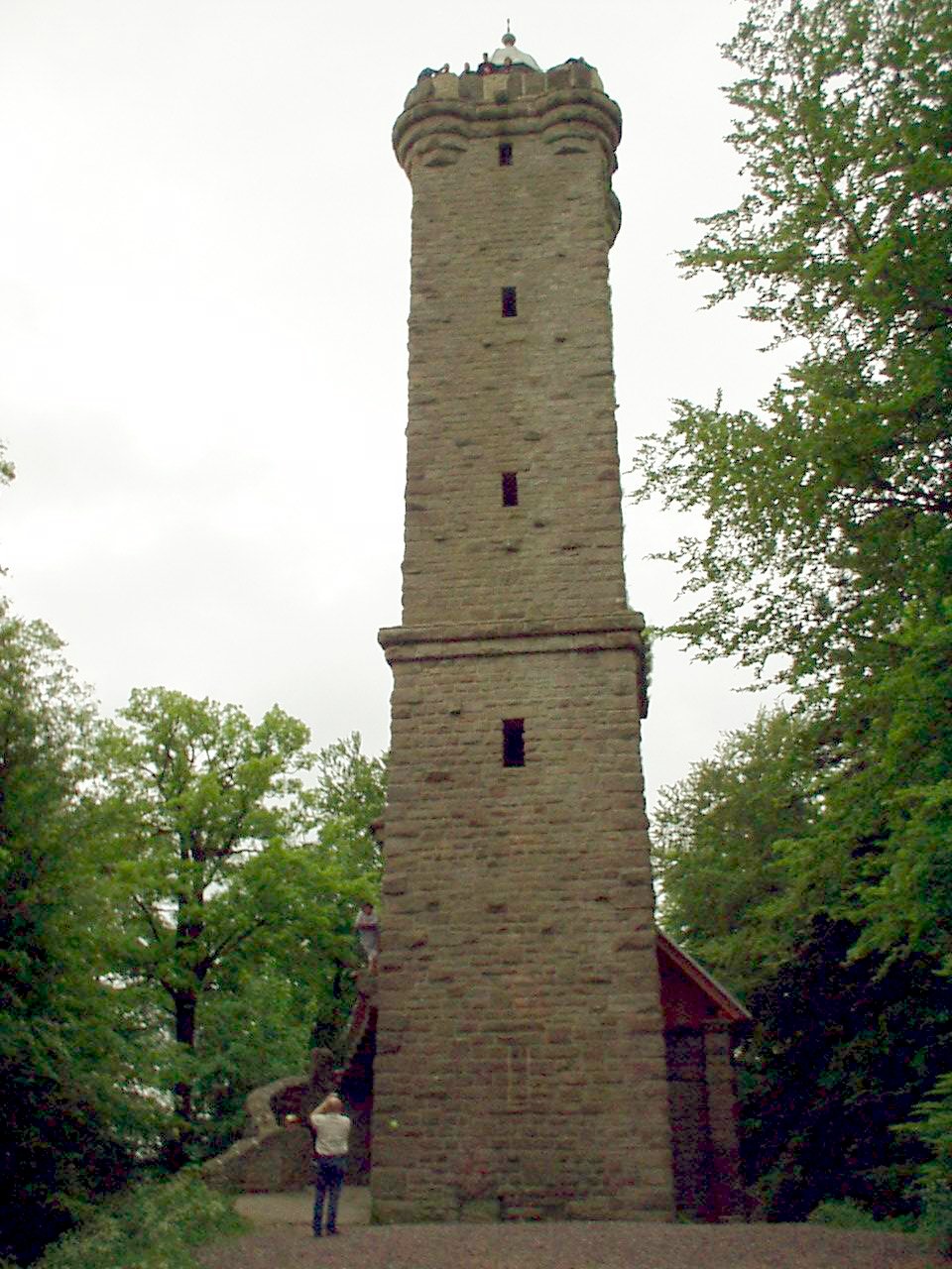
The Luitpold Tower (german: Luitpoldturm or ''Luitpoldsturm'') was erected in 1909 on the summit of one of the highest hills in the Palatine Forest, the 610-metre-high Weißenberg as an observation tower. It is made of bunter sandstone. History and construction The idea of building a tower was conceived on 29 May 1895 at the general assembly of the Gräfenstein Conservation Society (''Gräfensteiner Verschönerungsverein''), a group that forestry assessor August Zwissler from Leimen had founded in 1893. It was decided to build a viewing tower on the Weißenberg costing an estimated 8,000 to 10,000 gold marks. The necessary funding would be raised by society member Martin Jäger, a well known local poet who went under the pseudonym, Fritz Claus. Thanks to his support for the tower he was able to win the Palatine Forest Club, founded in 1902 in Ludwigshafen, to his cause. The leadership of the PWV took over the coordination of the project, had the plans produced by architect L ... [...More Info...] [...Related Items...] OR: [Wikipedia] [Google] [Baidu] |
Merzalben
Merzalben is a municipality in Südwestpfalz district, in Rhineland-Palatinate, western Germany, deriving its name from the Merzalbe, also known as the Merzalb, that flows through the village. Along with 5 other '' Ortsgemeinden'' ("local municipalities") Merzalben belongs to the '' Verbandsgemeinde Rodalben'' ("collective municipality of Rodalben") in Südwestpfalz, wherein it is the largest in terms of physical area, but the smallest in terms of population. The municipality contains several distinct natural and cultural landmarks, with the earliest known records dating back to 1237. It was also considered a state-approved tourist resort (German: '' Fremdenverkehrsort'') before the title was dropped in Rhineland Palatinate in 2016 and all communities awarded the designation were barred from its use in 2020. Geography Location The town is located in the Palatinate Forest (German: ''Pfälzerwald''), primarily within its sub-area Gräfenstein Land, with only the northeast po ... [...More Info...] [...Related Items...] OR: [Wikipedia] [Google] [Baidu] |
Gräfenstein Castle
Gräfenstein Castle (german: Burg Gräfenstein) is a ruined rock castle about east of the village of Merzalben in the German state of Rhineland-Palatinate. It is in the county of Südwestpfalz within the Palatine Forest and is often called ''Merzalber Schloss'' ("Merzalben Castle"). It is built on a rock plateau high at an elevation of above sea level. History Gräfenstein Castle was built by the Saarbrücken counts, who had lost their fortress and were in need of a new one. Evidence for the exact date of the castle's building does not exist although the earliest record dates to a 1237 deed of partition by the counts of Leiningen. But from the castle's design and materials it can be deduced that it was built sometime between 1150 and 1200. Another clue is in the date of the restoration of the stone fortress, which took place in 1168, and coincides with first construction work on Gräfenstein Castle. The central element of the site, with its ''bergfried'' and ''palas'' proba ... [...More Info...] [...Related Items...] OR: [Wikipedia] [Google] [Baidu] |
Bunter Sandstone
The Buntsandstein (German for ''coloured'' or ''colourful sandstone'') or Bunter sandstone is a lithostratigraphic and allostratigraphic unit (a sequence of rock strata) in the subsurface of large parts of west and central Europe. The Buntsandstein predominantly consists of sandstone layers of the Lower Triassic series and is one of three characteristic Triassic units, together with the Muschelkalk and Keuper that form the Germanic Trias Supergroup. The Buntsandstein is similar in age, facies and lithology with the Bunter of the British Isles. It is normally lying on top of the Permian Zechstein and below the Muschelkalk. In the past the name Buntsandstein was in Europe also used in a chronostratigraphic sense, as a subdivision of the Triassic system. Among reasons to abandon this use was the discovery that its base lies actually in the latest Permian. Origin The Buntsandstein was deposited in the Germanic Basin, a large sedimentary basin that was the successor of the smal ... [...More Info...] [...Related Items...] OR: [Wikipedia] [Google] [Baidu] |
Hiking
Hiking is a long, vigorous walk, usually on trails or footpaths in the countryside. Walking for pleasure developed in Europe during the eighteenth century.AMATO, JOSEPH A. "Mind over Foot: Romantic Walking and Rambling." In ''On Foot: A History of Walking'', 101-24. NYU Press, 2004. Accessed March 1, 2021. http://www.jstor.org/stable/j.ctt9qg056.7. Religious pilgrimages have existed much longer but they involve walking long distances for a spiritual purpose associated with specific religions. "Hiking" is the preferred term in Canada and the United States; the term "walking" is used in these regions for shorter, particularly urban walks. In the United Kingdom and the Republic of Ireland, the word "walking" describes all forms of walking, whether it is a walk in the park or backpacking in the Alps. The word hiking is also often used in the UK, along with rambling , hillwalking, and fell walking (a term mostly used for hillwalking in northern England). The term bushwalking is end ... [...More Info...] [...Related Items...] OR: [Wikipedia] [Google] [Baidu] |
Bundesstraße 10
The Bundesstraße 10 (abbr. B10) is a German federal highway. It leads from Eppelborn, near the city of Lebach in Saarland, eastward to Neusäß near Augsburg in Bavaria. The Bundesautobahn 8 mostly runs in parallel to the Bundesstraße 10. After a very short strip near Eppelborn leading to the Bundesautobahn 1, the road continues at Pirmasens. Because the construction of the A 8 through the Pfälzerwald never commenced, the Bundesstraße 10 has to carry the east-west traffic, though plans to upgrade the road to four lanes are underway. At Landau, the Bundesautobahn 65 replaces the Bundesstraße 10 up to the city of Wörth am Rhein, from where it continues to Karlsruhe, crossing the river Rhine, through Pforzheim, the city of Stuttgart, Göppingen, Ulm up to Neusäß, shortly before the city of Augsburg. Especially the part in Baden-Württemberg suffers from heavy traffic and high congestion, and there are attempts to improve the traffic situation by upgrading the road. Originall ... [...More Info...] [...Related Items...] OR: [Wikipedia] [Google] [Baidu] |
Lauter (Rhine)
The Lauter (in its upper course also: ''Wieslauter'') is a river in Germany and France. The Lauter is a left tributary of the Rhine. Its length is , of which 39 km is in France and on the France–Germany border. It is formed by the confluence of two headstreams (Scheidbach and Wartenbach) north of Hinterweidenthal in the Palatine Forest in the German state of Rhineland-Palatinate. It flows through Dahn, crosses the border with France, flows through Wissembourg, and then forms the French-German international boundary until its confluence with the Rhine near Lauterbourg and Neuburg am Rhein. See also * Lines of Wissembourg The Lines of Weissenburg, or Lines of Wissembourg,Note: also known as the Weissenburg Lines or Lignes de Wissembourg. The alternative spellings are derived from the German and French were entrenched works — an earthen rampart dotted with small ... * List of rivers of France * List of rivers of Rhineland-Palatinate References Rivers of Rhinela ... [...More Info...] [...Related Items...] OR: [Wikipedia] [Google] [Baidu] |
Schwarzbach (Blies)
The Schwarzbach is a river in southwestern Germany, left tributary of the Blies. Its source is in the Palatinate Forest, near Trippstadt. It flows through the states Rhineland-Palatinate and Saarland. Towns along its course are Waldfischbach-Burgalben, Contwig and Zweibrücken. After , it flows into the Blies in Homburg-Einöd. Tributaries and course The two headwaters of the Schwarzbach, the first of which is also known as ''Burgalb'', rise on western side of the watershed in the middle of the Palatinate Forest, just south of the hamlet Johanniskreuz, at an altitude of about 500 m. One spring is located on the southern slope of the 528 m high Mount Steinberg. The other spring is three kilometers away, on the southwest side of the high Mount Eschkopf. The two headwaters meet after about . The river then flows past Leimen into the Schwarzbach valley. It takes up the and the from the right and the from the left, before reaching the Clausensee reservoir ... [...More Info...] [...Related Items...] OR: [Wikipedia] [Google] [Baidu] |
Palatinate (region)
The Palatinate (german: Pfalz; Palatine German: ''Palz'') is a region of Germany. In the Middle Ages it was known as the Rhenish Palatinate (''Rheinpfalz'') and Lower Palatinate (''Unterpfalz''), which strictly speaking designated only the western part of the Electorate of the Palatinate (''Kurfürstentum Pfalz''), as opposed to the Upper Palatinate (''Oberpfalz''). It occupies roughly the southernmost quarter of the German federal state of Rhineland-Palatinate (''Rheinland-Pfalz''), covering an area of with about 1.4 million inhabitants. Its residents are known as Palatines (''Pfälzer''). Geography The Palatinate borders Saarland in the west, historically also comprising the state's Saarpfalz District. In the northwest, the Hunsrück mountain range forms the border with the Rhineland region. The eastern border with Hesse and the Baden region runs along the Upper Rhine river, while the left bank, with Mainz and Worms as well as the Selz basin around Alzey, belong to th ... [...More Info...] [...Related Items...] OR: [Wikipedia] [Google] [Baidu] |
Rodalben
Rodalben () is a municipality in the Südwestpfalz district, in Rhineland-Palatinate, Germany. It is situated in the Palatinate forest, approx. 5 km northeast of Pirmasens. Rodalben is the seat of the ''Verbandsgemeinde'' ("collective municipality") Rodalben. Having a population above 7000 it is the largest local authority district. History Rodalben was founded by a Celtic tribe. In 1237 Rodalben was first mentioned as a "Meyerhof". Over the centuries mainly farmers lived there. The origin of the name isn't clarified. The suffix "alb (alben)" is a Celtic word for rivers or brooks. Modern era Before the Thirty Years' War 150 people lived in the ''Amt'' of Gräfenstein. by 1680, around 30 years after the war, the ''Amt'' had 30 families or inhabitants. Around 50 years later, in 1698, there were 50, of which 20 lived in Rodalben. The village grew steadily and was given greater importance by the transfer of the administration of the Gräfenstein ''Amt'' to Rodalben. Arou ... [...More Info...] [...Related Items...] OR: [Wikipedia] [Google] [Baidu] |


