|
Grutness
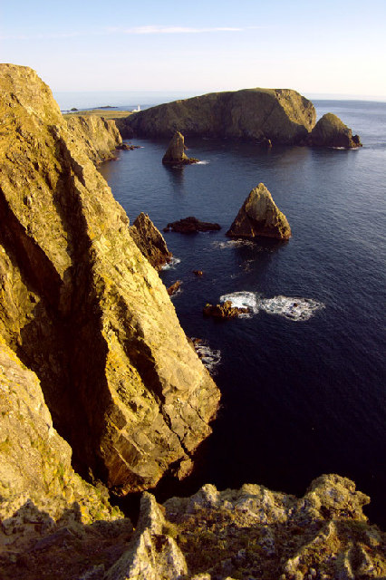
Grutness is a small settlement and headland at the southern tip of the main island of the Shetland Islands, Scotland. The settlement is within the parish of Dunrossness. It is located close to Sumburgh Head, and is the terminus of the ferry service between the Shetland Mainland and Fair Isle. It has a pebbly beach and seals, whales and orcas The orca or killer whale (''Orcinus orca'') is a toothed whale belonging to the oceanic dolphin family, of which it is the largest member. It is the only extant species in the genus ''Orcinus'' and is recognizable by its black-and-white pat ... can be seen in the sea nearby. References External links Shetlopedia entry for Grutness Villages in Mainland, Shetland {{Shetland-geo-stub ... [...More Info...] [...Related Items...] OR: [Wikipedia] [Google] [Baidu] |
Dunrossness
Dunrossness, (Old Norse: ''Dynrastarnes'' meaning "headland of the loud tide-race", referring to the noise of Sumburgh Roost) is the southernmost parish of Shetland, Scotland. Historically the name Dunrossness has usually referred to the area on the Shetland mainland south of Quarff. However, in 2016 there were three separate Shetland Community Councils for a) Gulberwick, Quarff and Cunningsburgh; b) Sandwick; and c) Dunrossness. The 2011 census defined Dunrossness as including everybody within the British ZE2 postal code, which goes as far north as Gulberwick. It has the best and largest area of fertile farmland of any parish in Shetland. Dunrossness includes the island of Mousa, Levenwick, St Ninian's Isle, Bigton, Scousburgh, the Lochs of Spiggie and Brow, Boddam, Quendale, Virkie, Exnaboe, Grutness, Toab, Ness of Burgi, Clumlie Broch, Scatness, Sumburgh Airport, Sumburgh Head, West Voe, the islands of Lady's Holm, Little Holm, Horse Holm island and Fair Isle. ... [...More Info...] [...Related Items...] OR: [Wikipedia] [Google] [Baidu] |
Sumburgh Head
Sumburgh Head is a headland located at the southern tip of the Shetland Mainland in northern Scotland. The head consists of a 100 m high rocky spur and topped by the Sumburgh Head Lighthouse. In the Old Norse language, Sumburgh Head was called ''Dunrøstar høfdi'', it means "The Head onto the loud tide-race", referring to the noise of Sumburgh Roost. Robert Stevenson was the engineer in charge of building the Sumburgh Head lighthouse. Work started on the building in 1819, and the light was first lit in 1821. Local ecology The area is now recognized as a nature reserve by the Royal Society for the Protection of Birds. The cliffs are home to large numbers of seabirds with 33,000 puffins being estimated in the year 2000. These numbers have declined sharply: for example only 570 of the birds were counted in 2017. The decline in Puffin numbers also appears to apply to other species native to Sumburgh Head. [...More Info...] [...Related Items...] OR: [Wikipedia] [Google] [Baidu] |
Fair Isle
Fair Isle (; sco, Fair Isle; non, Friðarey; gd, Fara) is an island in Shetland, in northern Scotland. It lies about halfway between mainland Shetland and Orkney. It is known for its bird observatory and a traditional style of knitting. The island has been owned by the National Trust for Scotland since 1954. Geography the most remote inhabited island in the United Kingdom. It is administratively part of the parish of Dunrossness, Shetland, and is roughly equidistant from Sumburgh Head, some to the northeast on the Mainland of Shetland and North Ronaldsay, Orkney, some to the southwest. Fair Isle is long and wide. It has an area of , making it the tenth-largest of the Shetland Islands. It gives its name to one of the British Sea Areas. Most of the islanders live in the crofts on the southern half of the island, the northern half consisting of rocky moorland. The western coast consists of cliffs of up to in height, Ward Hill at being the highest point of the islan ... [...More Info...] [...Related Items...] OR: [Wikipedia] [Google] [Baidu] |
Orkney And Shetland (UK Parliament Constituency)
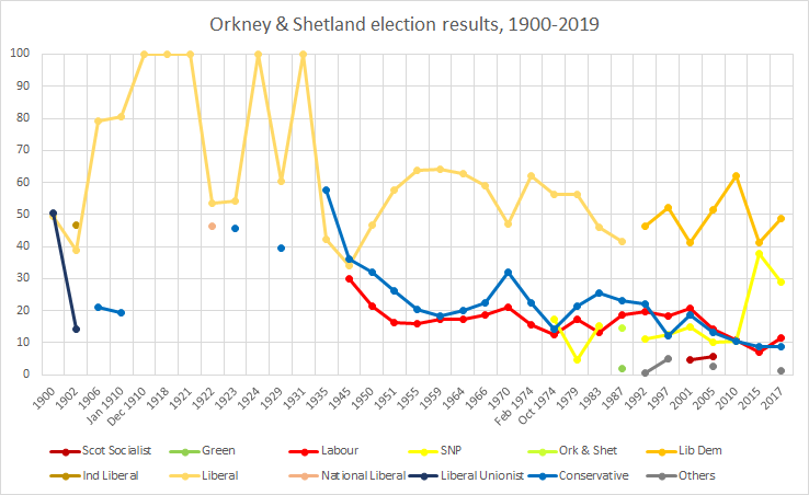
Orkney and Shetland is a constituency of the House of Commons of the Parliament of the United Kingdom. It elects one Member of Parliament (MP) by the first past the post system of election. In the Scottish Parliament, Orkney and Shetland are separate constituencies. The constituency was historically known as Orkney and Zetland (an alternative name for Shetland). In the 2014 Scottish independence referendum, 65.4% of the constituency's electors voted for Scotland to stay part of the United Kingdom. Creation The British parliamentary constituency was created in 1708 following the Acts of Union, 1707 and replaced the former Parliament of Scotland shire constituency of Orkney & Zetland. Boundaries The constituency is made up of the two northernmost island groups of Scotland, Orkney and Shetland. A constituency of this name has existed continuously since 1708. However, before 1918 the town of Kirkwall (the capital of Orkney) formed part of the Northern Burghs constituency. It i ... [...More Info...] [...Related Items...] OR: [Wikipedia] [Google] [Baidu] |
Shetland
Shetland, also called the Shetland Islands and formerly Zetland, is a subarctic archipelago in Scotland lying between Orkney, the Faroe Islands and Norway. It is the northernmost region of the United Kingdom. The islands lie about to the northeast of Orkney, from mainland Scotland and west of Norway. They form part of the border between the Atlantic Ocean to the west and the North Sea to the east. Their total area is ,Shetland Islands Council (2012) p. 4 and the population totalled 22,920 in 2019. The islands comprise the Shetland (Scottish Parliament constituency), Shetland constituency of the Scottish Parliament. The local authority, the Shetland Islands Council, is one of the 32 council areas of Scotland. The islands' administrative centre and only burgh is Lerwick, which has been the capital of Shetland since 1708, before which time the capital was Scalloway. The archipelago has an oceanic climate, complex geology, rugged coastline, and many low, rolling hills. The lar ... [...More Info...] [...Related Items...] OR: [Wikipedia] [Google] [Baidu] |
Shetland (Scottish Parliament Constituency)
Shetland is a constituency of the Scottish Parliament ( Holyrood) covering the council area of Shetland. It elects one Member of the Scottish Parliament (MSP) by the first past the post method of election. It is also one of eight constituencies in the Highlands and Islands electoral region, which elects seven additional members, in addition to the eight constituency MSPs, to produce a form of proportional representation for the region as a whole. Shetland has been held by the Liberal Democrats at all elections since the formation of the Scottish Parliament in 1999, with the current MSP being Beatrice Wishart, who won the seat at a 2019 by-election held following the resignation of former party leader Tavish Scott. Electoral region Shetland is part of the Highlands and Islands electoral region; the other seven constituencies of are Argyll and Bute, Caithness, Sutherland and Ross, Inverness and Nairn, Moray, Na h-Eileanan an Iar, Orkney and Skye, Lochaber and Badenoch ... [...More Info...] [...Related Items...] OR: [Wikipedia] [Google] [Baidu] |
Shetland Mainland
The Mainland is the main island of Shetland, Scotland. The island contains Shetland's only burgh, Lerwick, and is the centre of Shetland's ferry and air connections. Geography It has an area of , making it the third-largest Scottish island and the fifth largest of the British Isles after Great Britain, Ireland, Lewis and Harris and Skye. Mainland is the second most populous of the Scottish islands (only surpassed by Lewis and Harris), and had 18,765 residents in 2011 compared to 17,550 in 2001. The mainland can be broadly divided into four sections: *The long southern peninsula, south of Lerwick, has a mixture of moorland and farmland and contains many important archaeological sites. **Bigton, Cunningsburgh, Sandwick, Scalloway, and Sumburgh *The Central Mainland has more farmland and some woodland plantations. *The West Mainland **Aith, Walls, and Sandness *The North Mainland – in particular the large Northmavine peninsula, connected to Mainland by a narrow isthmus at Mav ... [...More Info...] [...Related Items...] OR: [Wikipedia] [Google] [Baidu] |
Shetland Islands
Shetland, also called the Shetland Islands and formerly Zetland, is a subarctic archipelago in Scotland lying between Orkney, the Faroe Islands and Norway. It is the northernmost region of the United Kingdom. The islands lie about to the northeast of Orkney, from mainland Scotland and west of Norway. They form part of the border between the Atlantic Ocean to the west and the North Sea to the east. Their total area is ,Shetland Islands Council (2012) p. 4 and the population totalled 22,920 in 2019. The islands comprise the Shetland constituency of the Scottish Parliament. The local authority, the Shetland Islands Council, is one of the 32 council areas of Scotland. The islands' administrative centre and only burgh is Lerwick, which has been the capital of Shetland since 1708, before which time the capital was Scalloway. The archipelago has an oceanic climate, complex geology, rugged coastline, and many low, rolling hills. The largest island, known as " the Mainland", ha ... [...More Info...] [...Related Items...] OR: [Wikipedia] [Google] [Baidu] |
Gazetteer For Scotland
The ''Gazetteer for Scotland'' is a gazetteer covering the geography, history and people of Scotland. It was conceived in 1995 by Bruce Gittings of the University of Edinburgh and David Munro of the Royal Scottish Geographical Society, and contains 25,870 entries as of July 2019. It claims to be "the largest dedicated Scottish resource created for the web". The Gazetteer for Scotland provides a carefully researched and editorially validated resource widely used by students, researchers, tourists and family historians with interests in Scotland. Following on from a strong Scottish tradition of geographical publishing, the ''Gazetteer for Scotland'' is the first comprehensive gazetteer to be produced for the country since Francis Groome's ''Ordnance Gazetteer of Scotland'' (1882-6) (the text of which is incorporated into relevant entries). The aim is not to produce a travel guide, of which there are many, but to write a substantive and thoroughly edited description of the count ... [...More Info...] [...Related Items...] OR: [Wikipedia] [Google] [Baidu] |
Orcas
The orca or killer whale (''Orcinus orca'') is a toothed whale belonging to the oceanic dolphin family, of which it is the largest member. It is the only extant species in the genus ''Orcinus'' and is recognizable by its black-and-white patterned body. A cosmopolitan species, orcas can be found in all of the world's oceans in a variety of marine environments, from Arctic and Antarctic regions to tropical seas. Orcas have a diverse diet, although individual populations often specialize in particular types of prey. Some feed exclusively on fish, while others hunt marine mammals such as seals and other species of dolphin. They have been known to attack baleen whale calves, and even adult whales. Orcas are apex predators, as they have no natural predators. They are highly social; some populations are composed of very stable matrilineal family groups (pods) which are the most stable of any animal species. Their sophisticated hunting techniques and vocal behaviours, which are oft ... [...More Info...] [...Related Items...] OR: [Wikipedia] [Google] [Baidu] |


