|
Great Zab River
The Great Zab or Upper Zab ( (''al-Zāb al-Kabīr''), or , , ''(zāba ʻalya)'') is an approximately long river flowing through Turkey and Iraq. It rises in Turkey near Lake Van and joins the Tigris in Iraq south of Mosul. The drainage basin of the Great Zab covers approximately , and during its course, the rivers collects the water from many tributaries. The river and its tributaries are primarily fed by rainfall and snowmelt – as a result of which discharge fluctuates highly throughout the year. At least six dams have been planned on the Great Zab and its tributaries, but construction of only one, the Bekhme Dam, has commenced but was halted after the Gulf War. The Zagros Mountains have been occupied since at least the Lower Palaeolithic, and Neanderthal occupation of the Great Zab basin has been testified at the archaeological site of Shanidar Cave. Historical records for the region are available from the end of the third millennium BCE onward. In the Neo-Assy ... [...More Info...] [...Related Items...] OR: [Wikipedia] [Google] [Baidu] |
Medieval Greek
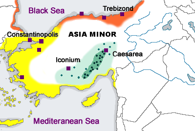
Medieval Greek (also known as Middle Greek, Byzantine Greek, or Romaic) is the stage of the Greek language between the end of classical antiquity in the 5th–6th centuries and the end of the Middle Ages, conventionally dated to the Ottoman conquest of Constantinople in 1453. From the 7th century onwards, Greek was the only language of administration and government in the Byzantine Empire. This stage of language is thus described as Byzantine Greek. The study of the Medieval Greek language and literature is a branch of Byzantine studies, the study of the history and culture of the Byzantine Empire. The beginning of Medieval Greek is occasionally dated back to as early as the 4th century, either to 330 AD, when the political centre of the Roman Empire was moved to Constantinople, or to 395 AD, the division of the empire. However, this approach is rather arbitrary as it is more an assumption of political, as opposed to cultural and linguistic, developments. Indeed, by this time ... [...More Info...] [...Related Items...] OR: [Wikipedia] [Google] [Baidu] |
Lower Paleolithic
The Lower Paleolithic (or Lower Palaeolithic) is the earliest subdivision of the Paleolithic or Old Stone Age. It spans the time from around 3 million years ago when the first evidence for stone tool production and use by hominins appears in the current archaeological record, until around 300,000 years ago, spanning the Oldowan ("mode 1") and Acheulean ("mode 2") lithics industries. In African archaeology, the time period roughly corresponds to the Early Stone Age, the earliest finds dating back to 3.3 million years ago, with Lomekwian stone tool technology, spanning Mode 1 stone tool technology, which begins roughly 2.6 million years ago and ends between 400,000 and 250,000 years ago, with Mode 2 technology. The Middle Paleolithic followed the Lower Paleolithic and recorded the appearance of the more advanced prepared-core tool-making technologies such as the Mousterian. Whether the earliest control of fire by hominins dates to the Lower or to the Middle Paleolithic remai ... [...More Info...] [...Related Items...] OR: [Wikipedia] [Google] [Baidu] |
Hakkâri Province
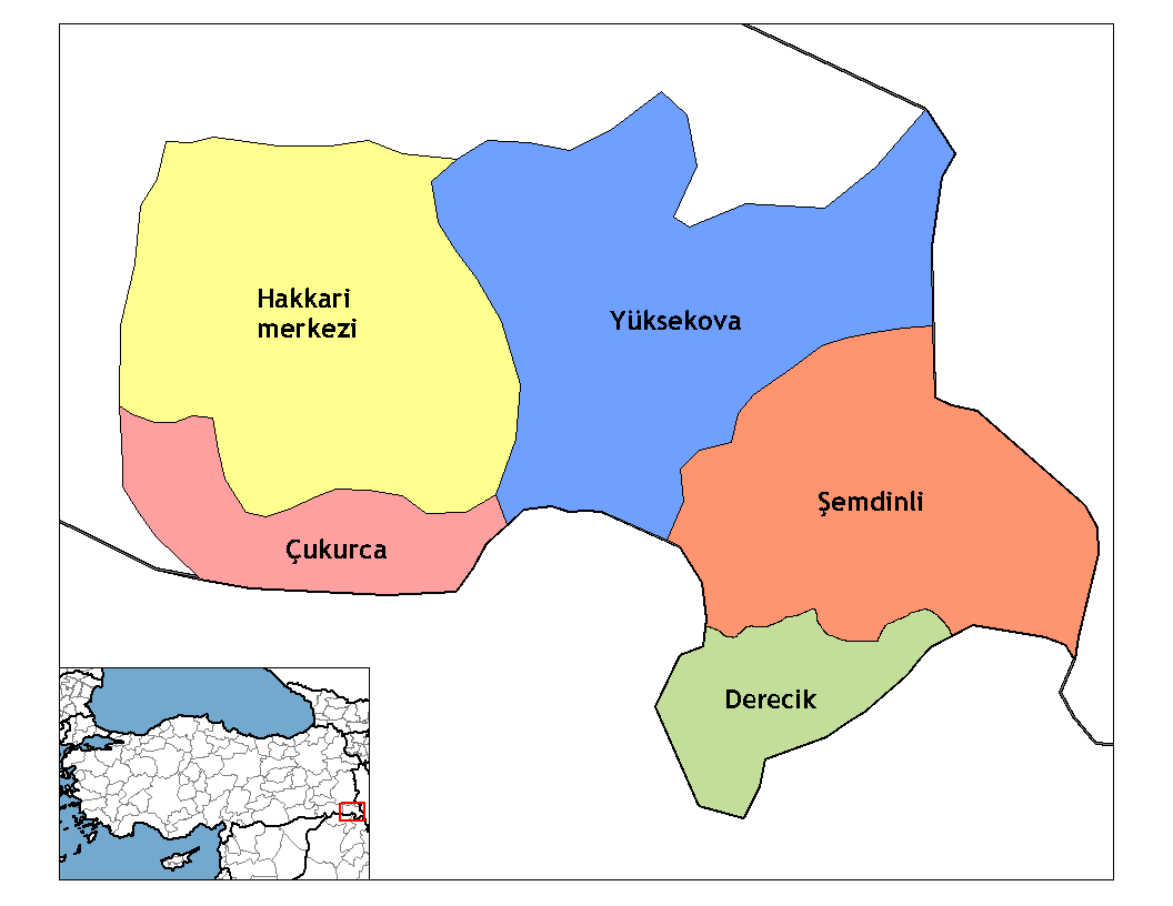
Hakkâri Province (, tr, Hakkâri ili, ku, Parêzgeha Colemêrgê), is a province in the southeast of Turkey. The administrative centre is the city of Hakkâri. The province covers an area of 7,121 km² and had a population of 286,470 in 2018. The province was created in 1936 out of Van Province and borders Şırnak Province to the west, Van Province to the north, Iran to the east, and Iraq to the south. The current Governor is İdris Akbıyık. The province is a stronghold for Kurdish nationalism and a hotspot in the Kurdish–Turkish conflict. Districts Hakkâri province is divided into five districts (capital district in bold): * Çukurca District * Derecik District (since 2018) *Hakkâri District *Şemdinli District *Yüksekova District Demographics Hakkari Province is located in Turkish Kurdistan and has an overwhelmingly Kurdish population. The province is tribal and most of the Kurds adhere to the Shafiʽi school with the Naqshbandi order having a strong ... [...More Info...] [...Related Items...] OR: [Wikipedia] [Google] [Baidu] |
Van Province
Van Province ( tr, Van ili, ku, Parezgêha Wanê, Armenian: Վանի մարզ) is a province in the Eastern Anatolian region of Turkey, between Lake Van and the Iranian border. It is 19,069 km2 in area and had a population of 1,035,418 at the end of 2010. Its adjacent provinces are Bitlis to the west, Siirt to the southwest, Şırnak and Hakkâri to the south, and Ağrı to the north. The capital of the province is the city of Van. The province is considered part of Western Armenia by Armenians and was part of ancient province of Vaspurakan. The region is considered to be the cradle of Armenian civilization. Before the Armenian genocide, Van Province was part of six Armenian vilayets. A majority of the province's modern day population is Kurdish. The current Governor is Mehmet Emin Bilmez. Demographics The province is mainly populated by Kurds and considered part of Turkish Kurdistan. The province had a significant Armenian population until the genocide in 1915. In t ... [...More Info...] [...Related Items...] OR: [Wikipedia] [Google] [Baidu] |
Above Mean Sea Level
Height above mean sea level is a measure of the vertical distance (height, elevation or altitude) of a location in reference to a historic mean sea level taken as a vertical datum. In geodesy, it is formalized as ''orthometric heights''. The combination of unit of measurement and the physical quantity (height) is called "metres above mean sea level" in the metric system, while in United States customary and imperial units it would be called "feet above mean sea level". Mean sea levels are affected by climate change and other factors and change over time. For this and other reasons, recorded measurements of elevation above sea level at a reference time in history might differ from the actual elevation of a given location over sea level at a given moment. Uses Metres above sea level is the standard measurement of the elevation or altitude of: * Geographic locations such as towns, mountains and other landmarks. * The top of buildings and other structures. * Flying objects such ... [...More Info...] [...Related Items...] OR: [Wikipedia] [Google] [Baidu] |
Kurdish People
ug:كۇردلار Kurds ( ku, کورد ,Kurd, italic=yes, rtl=yes) or Kurdish people are an Iranian peoples, Iranian ethnic group native to the mountainous region of Kurdistan in Western Asia, which spans southeastern Turkey, northwestern Iran, northern Iraq, and northern Syria. There are exclaves of Kurds in Central Anatolia Region, Central Anatolia, Khorasan Province, Khorasan, and the Caucasus, as well as significant Kurdish diaspora communities in the cities of western Turkey (in particular Istanbul) and Western Europe (primarily Kurds in Germany, in Germany). The Kurdish population is estimated to be between 30 and 45 million. Kurds speak the Kurdish languages and the Zaza–Gorani languages, which belong to the Western Iranian languages, Western Iranian branch of the Iranian languages. After World War I and the defeat of the Ottoman Empire, the victorious Allies of World War I, Western allies made provision for a Kurdish state in the 1920 Treaty of Sevres, Treaty ... [...More Info...] [...Related Items...] OR: [Wikipedia] [Google] [Baidu] |
Mongol Empire
The Mongol Empire of the 13th and 14th centuries was the largest contiguous land empire in history. Originating in present-day Mongolia in East Asia, the Mongol Empire at its height stretched from the Sea of Japan to parts of Eastern Europe, extending northward into parts of the Arctic; eastward and southward into parts of the Indian subcontinent, attempted invasions of Southeast Asia and conquered the Iranian Plateau; and westward as far as the Levant and the Carpathian Mountains. The Mongol Empire emerged from the unification of several nomadic tribes in the Mongol homeland under the leadership of Temüjin, known by the more famous title of Genghis Khan (–1227), whom a council proclaimed as the ruler of all Mongols in 1206. The empire grew rapidly under his rule and that of his descendants, who sent out invading armies in every direction. The vast transcontinental empire connected the East with the West, and the Pacific to the Mediterranean, in an enforced ''Pax Mongol ... [...More Info...] [...Related Items...] OR: [Wikipedia] [Google] [Baidu] |
Umayyad Caliphate
The Umayyad Caliphate (661–750 CE; , ; ar, ٱلْخِلَافَة ٱلْأُمَوِيَّة, al-Khilāfah al-ʾUmawīyah) was the second of the four major caliphates established after the death of Muhammad. The caliphate was ruled by the Umayyad dynasty ( ar, ٱلْأُمَوِيُّون, ''al-ʾUmawīyūn'', or , ''Banū ʾUmayyah'', "Sons of Umayyah"). Uthman ibn Affan (r. 644–656), the third of the Rashidun caliphs, was also a member of the clan. The family established dynastic, hereditary rule with Muawiya ibn Abi Sufyan, long-time governor of Greater Syria, who became the sixth caliph after the end of the First Fitna in 661. After Mu'awiyah's death in 680, conflicts over the succession resulted in the Second Fitna, and power eventually fell into the hands of Marwan I from another branch of the clan. Greater Syria remained the Umayyads' main power base thereafter, with Damascus serving as their capital. The Umayyads continued the Muslim conquests, incorpo ... [...More Info...] [...Related Items...] OR: [Wikipedia] [Google] [Baidu] |
Battle Of The Zab
The Battle of the Zab ( ar, معركة الزاب), also referred to in scholarly contexts as Battle of the Great Zāb River, took place on January 25, 750, on the banks of the Great Zab River in what is now the modern country of Iraq. It spelled the end of the Umayyad Caliphate and the rise of the Abbasids, a dynasty that would last from 750 to 1258. Background In 747, a major rebellion broke out against the Umayyad Caliphate, which ruled from southern Gaul to the western periphery of China from 661 to 750. The principal cause of the rebellion was the increasing gap between the outlying peoples of the Caliphate and the Damascus-based Umayyad government. The Umayyad-appointed governors of the Caliphate's various provinces were corrupt and interested only with personal gains. Additionally, the Umayyads claimed no direct descent from Muhammad, while the Abbasids did (they descended from Muhammad's uncle Abbas—a fact the latter used greatly during the revolution). The a ... [...More Info...] [...Related Items...] OR: [Wikipedia] [Google] [Baidu] |
Nimrud
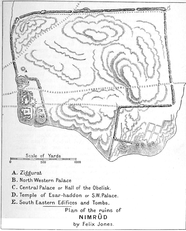
Nimrud (; syr, ܢܢܡܪܕ ar, النمرود) is an ancient Assyrian city located in Iraq, south of the city of Mosul, and south of the village of Selamiyah ( ar, السلامية), in the Nineveh Plains in Upper Mesopotamia. It was a major Assyrian city between approximately 1350 BC and 610 BC. The city is located in a strategic position north of the point that the river Tigris meets its tributary the Great Zab.Brill's Encyclopedia of Islam 1913-36 p.923 The city covered an area of . The ruins of the city were found within of the modern-day village of |
Irrigation
Irrigation (also referred to as watering) is the practice of applying controlled amounts of water to land to help grow Crop, crops, Landscape plant, landscape plants, and Lawn, lawns. Irrigation has been a key aspect of agriculture for over 5,000 years and has been developed by many cultures around the world. Irrigation helps to grow crops, maintain landscapes, and revegetation, revegetate disturbed soils in dry areas and during times of below-average rainfall. In addition to these uses, irrigation is also employed to protect crops from frost, suppress weed growth in grain fields, and prevent soil consolidation. It is also used to cool livestock, reduce dust, dispose of sewage, and support mining operations. Drainage, which involves the removal of surface and sub-surface water from a given location, is often studied in conjunction with irrigation. There are several methods of irrigation that differ in how water is supplied to plants. Surface irrigation, also known as gravity irri ... [...More Info...] [...Related Items...] OR: [Wikipedia] [Google] [Baidu] |
Neo-Assyrian Empire
The Neo-Assyrian Empire was the fourth and penultimate stage of ancient Assyrian history and the final and greatest phase of Assyria as an independent state. Beginning with the accession of Adad-nirari II in 911 BC, the Neo-Assyrian Empire grew to dominate the ancient Near East throughout much of the 8th and 7th centuries BC, becoming the largest empire in history up to that point. Because of its geopolitical dominance and ideology based in world domination, the Neo-Assyrian Empire is by many researchers regarded to have been the first world empire in history. At its height, the empire was the strongest military power in the world and ruled over all of Mesopotamia, the Levant and Egypt, as well as portions of Anatolia, Arabia and modern-day Iran and Armenia. The early Neo-Assyrian kings were chiefly concerned with restoring Assyrian control over much of northern Mesopotamia and Syria, since significant portions of the preceding Middle Assyrian Empire had been lost during a long ... [...More Info...] [...Related Items...] OR: [Wikipedia] [Google] [Baidu] |


.jpg)


