|
Goutum
Goutum is a village in the municipality Leeuwarden in the province of Friesland, the Netherlands. It had a population of around 2,945 in January 2017. It is still an independent village, but is surrounded by the city of Leeuwarden on all sides. There are two windmills in Goutum, ''Kramersmolen'' and ''Molen Hoogland''. History The village was first mentioned in 1366 as Goeltum, and means "settlement of Golde (person)". It was sometimes referred to as Dola-Goutum (Goutum on the border) to distinguish between Scharnegoutum. Goutum developed on several ''terps'' (artificial living mounds) in the middle ages. The '' stins'' Wiarda State was located near Goutum, and was first mentioned in the 14th century. It was owned by the son of Sjoerd Wiarda, the '' potestaat'' (comparable to governor) of Friesland. In 1481, the Wiardas and the villagers of Goutum participated in an attack on the city of Leeuwarden, and were defeated. In 1482, Wiarda State was demolished by Leeuwarden. The ... [...More Info...] [...Related Items...] OR: [Wikipedia] [Google] [Baidu] |
Kramersmolen, Goutum
Kramersmolen is a hollow post mill in Goutum, Friesland, Netherlands which was built in 2002. The mill is listed as a Rijksmonument, number 24508. (Click on "Technische gegevens" to view.) History The mill was originally built in the 18th century at Wirdum to drain the Wirdumer Nieuwland polder. At Wirdum, it was also known by the name of ''Old Barrahûs''. It has always formed a pair with ''Molen Hoogland''. (Click on "Geschiedenis" to view.) On 1 March 1949, the cap and sails were blown of in a storm. The mill was soon repaired. The mill was restored in 1968-69. On 30 September 1986, the mill was sold to Stichting De Fryske Mole ( en, Frisian Mills Foundation). In 1995, it was moved to Zwette, along with ''Molen Hoogland''. Following the latter mill's destruction by fire in 1999, another site was sought and the mill was moved to Goutum in 2002. The mill was officially re-opened on 24 October 2002. The mill is kept in full working order and held in reserve should it be needed ... [...More Info...] [...Related Items...] OR: [Wikipedia] [Google] [Baidu] |
Protestant Church Of Goutum
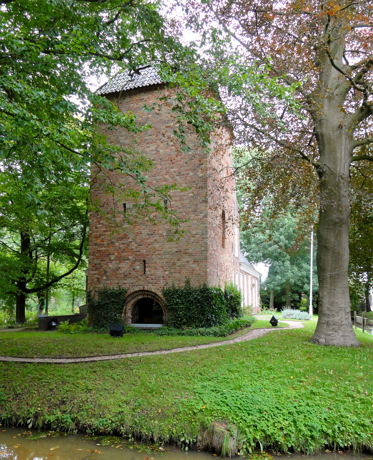
The Protestant church of Goutum or Saint Agnes churchAlle middeleeuwse kerken: van Harlingen tot Wilhelmshaven, P Karstkarel, p. 123 is a medieval religious building in Goutum, Friesland, Netherlands. On the north side remnants of an older tufa church from the 11th century or 12th century can be seen. The church was enlarged and heightened with brick in the 15th century and has a tower from the same century. The church was originally a Roman Catholic church dedicated to Saint Agnes, becoming a Protestant church after the Protestant Reformation. It is listed as a Rijksmonument, number 24509. The building is located at 23 Buorren. References {{reflist Goutum Goutum is a village in the municipality Leeuwarden in the province of Friesland, the Netherlands. It had a population of around 2,945 in January 2017. It is still an independent village, but is surrounded by the city of Leeuwarden on all sides. Th ... Rijksmonuments in Friesland Protestant churches in the Netherland ... [...More Info...] [...Related Items...] OR: [Wikipedia] [Google] [Baidu] |
Molen Hoogland, Goutum
Molen Hoogland is a Hollow Post mill in Goutum, Friesland, Netherlands which was built in 2004. The mill is listed as a Rijksmonument, number 24521. (Click on "Technische gegevens" to view.) History The mill was originally built in the 18th century at Wirdum to drain the Wirdumer Nieuwland polder, forming a pair with the ''Kramersmolen''. (Click on "Geschiedenis" to view.) The mill was restored in 1971. The mill was restored in 1968-69. On 23 October 1986, the mill was sold to Stichting De Fryske Mole ( en, Frisian Mills Foundation). In 1995, it was moved to Zwette, along with ''Kramersmolen''. On 21 April 1999, the mill was burnt down. The cause was probably arson Arson is the crime of willfully and deliberately setting fire to or charring property. Although the act of arson typically involves buildings, the term can also refer to the intentional burning of other things, such as motor vehicles, wat .... A new site was sought at Goutum. (Click on "Geschiedenis" to v ... [...More Info...] [...Related Items...] OR: [Wikipedia] [Google] [Baidu] |
Leeuwarden
Leeuwarden (; fy, Ljouwert, longname=yes /; Town Frisian: ''Liwwadden''; Leeuwarder dialect: ''Leewarden'') is a city and municipality in Friesland, Netherlands, with a population of 123,107 (2019). It is the provincial capital and seat of the Provincial Council of Friesland. It is located about 50 km west of Groningen and 110 km north east from the Dutch capital Amsterdam (as the crow flies). The region has been continuously inhabited since the 10th century. It came to be known as Leeuwarden in the early 9th century AD and was granted city privileges in 1435. It is the main economic hub of Friesland, situated in a green and water-rich environment. Leeuwarden is a former royal residence and has a historic city centre, many historically relevant buildings, and a large shopping centre with squares and restaurants. Leeuwarden was awarded the title European Capital of Culture for 2018. The Elfstedentocht (Eleven Cities Tour), an ice skating tour passing the eleven cities of Fri ... [...More Info...] [...Related Items...] OR: [Wikipedia] [Google] [Baidu] |
Sjoerd Wiarda
Sjoerd Pijbes Wiarda (in office 1399–1410) was the fifteenth potestaat (or elected governor) of Friesland now a province of the Netherlands. Sjoerd Wiarda born in 1355 and died in 1410. He was the son of Pybe Wyarda and Claer van Eminga. He lived on Wiarda estate at Goutum. He was the last potestaat to rule both Oostergo and Westergo. Wiarda was the leader in the fight against the Count of Holland. In 1398 he was a delegate to the convention with Willem van Beijeren, Count of Holland. He was elected in 1399, succeeding Odo Botnia as potestaat. In 1400 he fought as a Schieringer in the Battle of Dokkum and Camminghastins. Succession In 1400 there were several potestaats chosen for Oostergo and Westergo because of the religious disputes between Schieringers and Vetkopers. Haring Haringsma Haring Harinxma (1323–1404) was a powerful Frisian chieftain and Schieringer who lived during the 13th and early 14th centuries. Haring also used the surname Donia, and is considered the ... [...More Info...] [...Related Items...] OR: [Wikipedia] [Google] [Baidu] |
Council Of State (Netherlands)
The Council of State ( nl, ) is a constitutionally established advisory body in the Netherlands to the government and States General that officially consists of members of the royal family and Crown-appointed members generally having political, commercial, diplomatic or military experience. It was founded in 1531, making it one of the world's oldest still-functioning state organisations. The Council of State must be consulted by the cabinet on proposed legislation before a law is submitted to parliament. The Council of State Administrative Law division also serves as one of the four highest courts of appeal in administrative matters. The King is president of the Council of State but he seldom chairs meetings. The Vice-President of the Council of State chairs meetings in his absence and is the ''de facto'' major personality of the institution. Under Dutch constitutional law, the Vice-President of the Council is acting head of state when there is no monarch such as if the royal fa ... [...More Info...] [...Related Items...] OR: [Wikipedia] [Google] [Baidu] |
Van Harinxmakanaal
The van Harinxmakanaal is a major canal in western Frisland. It runs from the sea at Harlingen eastwards to Leeuwarden. Major places along the canal include Franeker, Dronrijp and Deinum Deinum is a village in Waadhoeke municipality in Friesland, The Netherlands. Before 2018, the village was part of the Menameradiel municipality. Population In 2017 Deinum had a total of 915 residents, of which 508 male and 482 female. The amount .... The canal is 37.5 kilometers long. It was named after Pieter Albert Vincent van Harinxma thoe Slooten in 1950 who was King's Commissioner to Friesland from 1909 to 1945. Prior to this date it was called Harlinger Trekvaart. However this was widened and deepened, and a few corners cut off in 1951. At Suawoude it joins the Prinses Margrietkanaal. The lock Tsjerk Hiddessluizen situated at the connection to the Harlingen harbour maintains the water level in the canal. The canal water level is connected to the water system called Friese boezem ... [...More Info...] [...Related Items...] OR: [Wikipedia] [Google] [Baidu] |
Stins
A stins (Dutch, pl. ''stinsen''; from West Frisian ''stienhûs'' utch ''steenhuis''"stone house", shortened to ''stins'', pl. ''stinzen'') is a former stronghold or villa in the province of Friesland, the Netherlands. Many stinsen carry the name "''state''" (related to English 'estate'). Stinsen used to belong to noblemen or prominent citizens. Most stinsen were demolished in the 19th century, when maintenance became too expensive. Several surviving stinsen are now used as museums. Stinsen also appear in East Frisia, and are known as ''borg'' (pl. ''borgen'') in the province of Groningen. See also * List of stins in Friesland * List of castles in the Netherlands This is a list of castles in the Netherlands per province. Overview of castles in the Netherlands Drenthe See also ''List of havezates in Drenthe'' Flevoland Friesland See ''List of stins in Friesland'' Gelderland Groningen See ''List o ... References External links Stinsen in Friesland {{Expand Dutch, ... [...More Info...] [...Related Items...] OR: [Wikipedia] [Google] [Baidu] |
Terp
A ''terp'', also known as a ''wierde, woerd, warf, warft, werf, werve, wurt'' or ''værft'', is an artificial dwelling mound found on the North European Plain that has been created to provide safe ground during storm surges, high tides and sea or river flooding. The various terms used reflect the regional dialects of the North European region. In English sources, ''terp'' appears to be by far the most common term used. These mounds occur in the coastal parts of the Netherlands (in the provinces of Zeeland, Friesland and Groningen), in southern parts of Denmark and in the north-western parts of Germany where, before dykes were made, floodwater interfered with daily life. These can be found especially in the region Ostfriesland and Kreis Nordfriesland in Germany. In Kreis Nordfriesland on the Halligen, people still live on terps unprotected by dykes. Terps also occur in the Rhine and Meuse river plains in the central part of the Netherlands. Furthermore, terps can be fou ... [...More Info...] [...Related Items...] OR: [Wikipedia] [Google] [Baidu] |
Scharnegoutum
Scharnegoutum ( fry, Skearnegoutum) is a village in Súdwest Fryslân in the province of Friesland, the Netherlands. It had a population of around 1,660 in January 2017. - CBS Statline History Scharnegoutum is built upon a man-made hill (called a in Dutch). During excavations of the hill objects from the 4th century were found. The village was at one time beside the Middelzee until this was drained in about 1300. In the Middle Ages Scharnegoutum possessed a covenant, similar to the situation in the villages[...More Info...] [...Related Items...] OR: [Wikipedia] [Google] [Baidu] |
Netherlands
) , anthem = ( en, "William of Nassau") , image_map = , map_caption = , subdivision_type = Sovereign state , subdivision_name = Kingdom of the Netherlands , established_title = Before independence , established_date = Spanish Netherlands , established_title2 = Act of Abjuration , established_date2 = 26 July 1581 , established_title3 = Peace of Münster , established_date3 = 30 January 1648 , established_title4 = Kingdom established , established_date4 = 16 March 1815 , established_title5 = Liberation Day (Netherlands), Liberation Day , established_date5 = 5 May 1945 , established_title6 = Charter for the Kingdom of the Netherlands, Kingdom Charter , established_date6 = 15 December 1954 , established_title7 = Dissolution of the Netherlands Antilles, Caribbean reorganisation , established_date7 = 10 October 2010 , official_languages = Dutch language, Dutch , languages_type = Regional languages , languages_sub = yes , languages = , languages2_type = Reco ... [...More Info...] [...Related Items...] OR: [Wikipedia] [Google] [Baidu] |


