|
Gondia Airport
Gondia Airport is located at Birsi village, 12 kilometres north-east of Gondia, Maharashtra, India. It is a domestic airport serving Gondia city and surrounding areas and also used for general aviation and pilot training. History The airstrip was built by the British in 1940. Initially run by the Public Works Department, it was taken over by the state-owned Maharashtra Industrial Development Corporation (MIDC) in August 1998 to December 2005, after which it has been operated by the Airports Authority of India (AAI). The AAI extended the runway at Gondia airport to 7,500 feet to handle larger aircraft such as Airbus A320 and Boeing 737. Description Gondia airport has a single runway (04/22), 2,290 metres long and 45 metres wide with a parallel taxiway of 1,697 metres. The main apron measures 100 m x 150 m. The airport is equipped with a Non Directional Beacon and DVOR, Distance Measuring Equipment, Instrument Landing System and night landing facilities. Airlines and destinatio ... [...More Info...] [...Related Items...] OR: [Wikipedia] [Google] [Baidu] |
Airports Authority Of India
The Airports Authority of India, or AAI, is a public sector enterprise under the ownership of the Ministry of Civil Aviation, Government of India. It is responsible for creating, upgrading, maintaining, and managing civil aviation infrastructure in India. It provides Communication Navigation Surveillance/Air Traffic Management (CNS/ATM) services over Indian airspace and adjoining oceanic areas. AAI is currently managing a total of 137 airports, including 34 international airports, 10 Customs Airports, 81 domestic airports, and 23 Civil enclaves at defense airfields. AAI also has ground installations at all airports and 25 other locations to ensure the safety of aircraft operations. AAI covers all major air routes over Indian landmass via 29 Radar installations at 11 locations along with 700 VOR/DVOR installations co-located with Distance Measuring Equipment (DME). 52 runways are provided with Instrument landing system (ILS) installations with Night Landing Facilities at most o ... [...More Info...] [...Related Items...] OR: [Wikipedia] [Google] [Baidu] |
Distance Measuring Equipment
In aviation, distance measuring equipment (DME) is a radio navigation technology that measures the slant range (distance) between an aircraft and a ground station by timing the propagation delay of radio signals in the frequency band between 960 and 1215 megahertz (MHz). Line-of-visibility between the aircraft and ground station is required. An interrogator (airborne) initiates an exchange by transmitting a pulse pair, on an assigned 'channel', to the transponder ground station. The channel assignment specifies the carrier frequency and the spacing between the pulses. After a known delay, the transponder replies by transmitting a pulse pair on a frequency that is offset from the interrogation frequency by 63 MHz and having specified separation.''Annex 10 to the Convention on International Civil Aviation, Volume I – Radio Navigation Aids''; International Civil Aviation Organization; International Standards and Recommended Practices. DME systems are used worldwide, usi ... [...More Info...] [...Related Items...] OR: [Wikipedia] [Google] [Baidu] |
Vidarbha
Vidarbha (Pronunciation: Help:IPA/Marathi, [ʋid̪əɾbʱə]) is a geographical region in the east of the Indian state of Maharashtra and a Proposed states and union territories of India#Maharashtra, proposed state of central India, comprising the state's Amravati Division, Amravati and Nagpur Division, Nagpur divisions. Amravati Division's former name is Berar Province, Berar (Varhad in Marathi language, Marathi). It occupies 31.6% of the total area and holds 21.3% of the total population of Maharashtra. It borders the state of Madhya Pradesh to the north, Chhattisgarh to the east, Telangana to the south and Marathwada and North Maharashtra regions of Maharashtra to the west. Situated in central India. The largest city in Vidarbha is Nagpur followed by Amravati, Akola, and Chandrapur. A majority of Vidarbhians speak Varhadi and Zadi dialects of Marathi. The Nagpur region is known for growing Orange (fruit), oranges and cotton. Vidarbha holds two-thirds of Maharashtra's mineral re ... [...More Info...] [...Related Items...] OR: [Wikipedia] [Google] [Baidu] |
Airports In Maharashtra
An airport is an aerodrome with extended facilities, mostly for commercial air transport. Airports usually consists of a landing area, which comprises an aerially accessible open space including at least one operationally active surface such as a runway for a plane to take off and to land or a helipad, and often includes adjacent utility buildings such as control towers, hangars and terminals, to maintain and monitor aircraft. Larger airports may have airport aprons, taxiway bridges, air traffic control centres, passenger facilities such as restaurants and lounges, and emergency services. In some countries, the US in particular, airports also typically have one or more fixed-base operators, serving general aviation. Operating airports is extremely complicated, with a complex system of aircraft support services, passenger services, and aircraft control services contained within the operation. Thus airports can be major employers, as well as important hubs for tourism and ... [...More Info...] [...Related Items...] OR: [Wikipedia] [Google] [Baidu] |
CAE Inc
CAE Inc. (formerly Canadian Aviation Electronics) is a Canadian manufacturer of simulation technologies, modelling technologies and training services to airlines, aircraft manufacturers, healthcare specialists, and defence customers. CAE was founded in 1947, and has manufacturing operations and training facilities in 35 countries. In 2017, the company's annual revenue was CAD $2.705 billion. Flight simulators CAE sells flight simulators and training devices to airlines, aircraft manufacturers and training centres. It licenses its simulation software to various market segments and has a professional services division. The simulators include basic training devices CAE 400XR and CAE 500XR, and full-motion products such as the CAE 3000, CAE 5000 and CAE 7000XR. These simulators are available for commercial use. In 2016, the company sold 53 Full-Flight Simulators. In 2001, CAE Inc. acquired BAE Systems's Flight Simulation and Training division, formerly known as Reflectone Inc, a p ... [...More Info...] [...Related Items...] OR: [Wikipedia] [Google] [Baidu] |
Directorate General Of Civil Aviation (India)
The Directorate General of Civil Aviation (DGCA) is a statutory body of the Government of India to regulate civil aviation in India. It became a statutory body under the Aircraft (Amendment) Act, 2020. The DGCA investigates aviation accidents and incidents, maintains all regulations related to aviation and is responsible for issuance of licenses pertaining to aviation like PPL's, SPL's and CPL's in India. It is headquartered along Sri Aurobindo Marg, opposite Safdarjung Airport, in New Delhi. The Government of India is planning to replace the organisation with a Civil Aviation Authority (CAA), modelled on the lines of the American Federal Aviation Administration (FAA). Vision Endeavour to promote safe and efficient Air Transportation through regulation and proactive safety oversight system. Functions #Registration of civil aircraft #Certification of airports #Licensing to pilots, aircraft maintenance engineers, air traffic controllers and flight engineers, and conducting e ... [...More Info...] [...Related Items...] OR: [Wikipedia] [Google] [Baidu] |
Devi Ahilya Bai Holkar Airport
Devi Ahilya Bai Holkar Airport is an international airport that principally serves Indore and adjacent regions in Madhya Pradesh. It is the busiest airport in Central India and is located west of Indore. According to the statistics released by the Airports Authority of India (AAI), the agency responsible for the maintenance and management of the airport, it was the 18th busiest airport in India by passenger traffic in the year 2018-19. The airport is named after Maharani Ahilya Bai Holkar of Indore, belonging to the Holkar dynasty of the Maratha Empire. Devi Ahilya Bai Holkar Airport was adjudged as the best airport in under 20 lakh (2 million) annual passenger footfall category in Asia-Pacific region in the Airports Council International (ACI)'s airport service quality (ASQ) rankings for the year 2017. The World Book of Records, UK bestowed Worlds Standardisation Certification to Devi Ahilya Bai Holkar Airport for the achievement of ACI Award 2017 on 9 April 2018. Since 24 ... [...More Info...] [...Related Items...] OR: [Wikipedia] [Google] [Baidu] |
FlyBig
flybig is a regional airline based in Indore, Madhya Pradesh, India. It is promoted by Gurugram-based Big Charter Private Limited. The airline began operations in December 2020 and is focused on connecting tier-2 cities within India. History The company has received a No Objection Certificate from the Ministry of Civil Aviation and received its Air Operator's Certificate (AoC) on 14 December 2020. It began operations with a single ATR-72-500. The company's focus is to serve Tier-2 cities and it aims to build a fleet of more ATR-72s and HAL manufactured Dornier 228 aircraft and eventually expand to a fleet of 20. Before the airline began any scheduled flights, it had won its first route under a government tender to serve Shillong from Delhi. The flights commenced on 21 December 2020 and to fulfil its obligations, the airline wet-leased a Dash 8 Q400 from SpiceJet. The airline conducted proving flights on 4 December 2020 and operated its first scheduled flight on 3 January 2021 ... [...More Info...] [...Related Items...] OR: [Wikipedia] [Google] [Baidu] |
Instrument Landing System
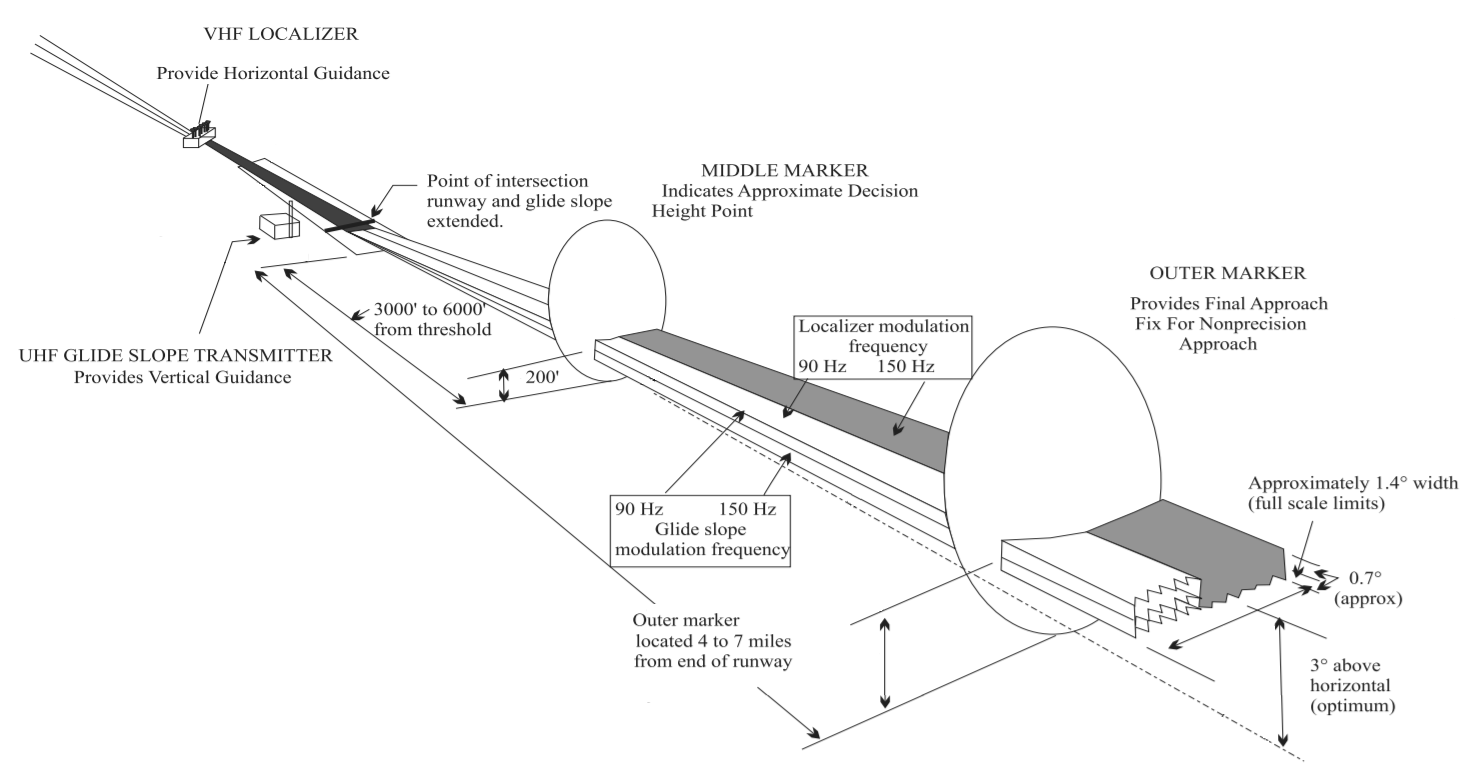
In aviation, the instrument landing system (ILS) is a precision radio navigation system that provides short-range guidance to aircraft to allow them to approach a runway at night or in bad weather. In its original form, it allows an aircraft to approach until it is over the ground, within a of the runway. At that point the runway should be visible to the pilot; if it is not, they perform a missed approach. Bringing the aircraft this close to the runway dramatically increases the range of weather conditions in which a safe landing can be made. Other versions of the system, or "categories", have further reduced the minimum altitudes, runway visual ranges (RVRs), and transmitter and monitoring configurations designed depending on the normal expected weather patterns and airport safety requirements. ILS uses two directional radio signals, the ''localizer'' (108 to 112 MHz frequency), which provides horizontal guidance, and the ''glideslope'' (329.15 to 335 MHz frequency ... [...More Info...] [...Related Items...] OR: [Wikipedia] [Google] [Baidu] |
VHF Omnidirectional Range
Very high frequency omnirange station (VOR) is a type of short-range radio navigation system for aircraft, enabling aircraft with a receiving unit to determine its position and stay on course by receiving radio signals transmitted by a network of fixed ground radio beacons. It uses frequencies in the very high frequency (VHF) band from 108.00 to 117.95 MHz. Developed in the United States beginning in 1937 and deployed by 1946, VOR became the standard air navigational system in the world,VOR VHF omnidirectional Range , Aviation Tutorial – Radio Navaids, kispo.net used by both commercial and general aviation, until supplanted by satellite navigation systems such as in th ... [...More Info...] [...Related Items...] OR: [Wikipedia] [Google] [Baidu] |
Gondia
Gondia (also spelled Gondiya) is a city and municipal council in the Indian state of Maharashtra which serves the administrative headquarters of the eponymous administrative district. Gondia is also known as ''Rice City'' due to the abundance of rice mills in the area.Gondia Airport is only airport in district. Industry Adani Power Maharashtra Limited (APML), is 3 km away from Tirora on Tirora-Gondia state road. Coal is transported to Adani power, Ltd through a railway which is connected to Kachewani Railway Station. Water is being used from nearby weir constructed on Wainganga River. An 85.89% subsidiary of Adani Power Limited is implementing 3300 MW Thermal Power Station in Tirora. History The region is named after the Gondi people, an Adivasi group in central India. During British rule in India, the Great Famine of 1876–78 provided an opportunity for the construction of a metre-gauge rail link called the Nagpur Chhattisgarh Railway, connecting Nagpur with Rajnandgao ... [...More Info...] [...Related Items...] OR: [Wikipedia] [Google] [Baidu] |


