|
Geography Of Ladakh
Ladakh is an administrative territory of India that has been under its control since 1947. The geographical region of Ladakh union territory is the highest altitude plateau region in India (much of it being over 3,000 m), incorporating parts of the Himalayan and Karakoram mountain ranges and the upper Indus River and valley. Political geography Historic Ladakh consists of a number of distinct areas (mainly under Indian rule), including the fairly populous main Indus valley, the more remote Zanskar (in the south) and Nubra valleys (to the north over Khardung La in the Ladakh mountain range, a high motorable pass at ), the almost deserted Aksai Chin (under Chinese rule) and the predominantly Shi'ite Muslim Kargil and Suru valley areas in the west (Kargil being the second most important town in Ladakh). Historically populated by the Ladakhi people, continued immigration and preferential treatment to Kashmiris by the J&K government have led to demographic changes in the ... [...More Info...] [...Related Items...] OR: [Wikipedia] [Google] [Baidu] |
Ladakh Range
The Ladakh Range is a mountain range in central Ladakh in India with its northern tip extending into Baltistan in Pakistan. It lies between the Indus and Shyok river valleys, stretching to 230 miles (370 km). Leh, the capital city of Ladakh, is on the foot of Ladakh Range in the Indus river valley. Geography The Ladakh Range is regarded as a southern extension of the Karakoram Range, which runs for 230 miles (370 km) from the confluence of the Indus and Shyok rivers in Baltistan to the Tibetan border of Ladakh in the southeast. Encyclopedia Britannica, retrieved 22 April 2018. The southern extension of the Ladakh Range is called the , especially in Tibet. The Ladakh Range forms the n ... [...More Info...] [...Related Items...] OR: [Wikipedia] [Google] [Baidu] |
Zanskar Range
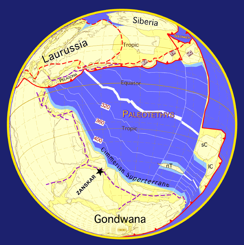
Zanskar, Zahar (locally) or Zangskar, is a tehsil of Kargil district, in the Indian union territory of Ladakh. The administrative centre is Padum (former Capital of Zanskar). Zanskar, together with the neighboring region of Ladakh, was briefly a part of the kingdom of Guge in Western Tibet. Zanskar lies 250 km south of Kargil town on NH301. The Zanskar Range is a mountain range in the union territory of Ladakh that separates the Zanskar valley from Indus valley at Leh. Geologically, the Zanskar Range is part of the Tethys Himalaya, an approximately 100-km-wide synclinorium formed by strongly folded and imbricated, weakly metamorphosed sedimentary series. The average height of the Zanskar Range is about 6,000 m (19,700 ft). Its eastern part is known as Rupshu. The Zanskar had a population of approximately 20,000 in 2020. There has been demands to convert Zanskar into a district. Etymology Zanskar ( ''zangs dkar'') appears as ''“Zangskar”'' mostly in aca ... [...More Info...] [...Related Items...] OR: [Wikipedia] [Google] [Baidu] |
Ngari
Ngari Prefecture () or Ali Prefecture () is a prefecture of China's Tibet Autonomous Region covering Western Tibet, whose traditional name is Ngari Khorsum. Its administrative centre and largest settlement is the town of Shiquanhe. History Ngari was once the heart of the ancient kingdom of Guge. Later Ngari, along with Ü and Tsang, composed Ü-Tsang, one of the traditional provinces of Tibet, the others being Amdo and Kham. The lowlands of Ngari is known as Maryul. During the 10th century, the kingdom of Maryul was founded, taking the name Ladakh, lasted until 1842. The prefecture has close cultural links with Kinnaur and Lahaul and Spiti district of the bordering Indian state of Himachal Pradesh. Geography and climate The paved Xinjiang-Tibet Highway () passes through this area. There are well-known prehistoric petroglyphs near the far western town of Rutog. The town of Ngari lies above sea level in northwest Tibet some west of the capital, Lhasa. Ngari Gunsa Airport ... [...More Info...] [...Related Items...] OR: [Wikipedia] [Google] [Baidu] |
Kailas
Mount Kailash (also Kailasa; ''Kangrinboqê'' or ''Gang Rinpoche''; Tibetan: གངས་རིན་པོ་ཆེ; ; sa, कैलास, ), is a mountain in the Ngari Prefecture, Tibet Autonomous Region of China. It has an altitude of . It lies in the Kailash Range (Gangdisê Mountains) of the Transhimalaya, in the western part of the Tibetan Plateau. Mount Kailash is less than 100 km towards the north from the western trijunction of the borders of China, India, and Nepal. Mount Kailash is located close to Lake Manasarovar and Lake Rakshastal. The sources of four major Asian rivers lie close to this mountain and the two lakes. These rivers are the Indus, the Sutlej, the Brahmaputra, and the Karnali (a tributary of the Ganges). Mount Kailash is considered sacred in four religions: Hinduism, Buddhism, Jainism and Bon. Etymology The mountain is known as “'” (; var. ' ) in Sanskrit. The name also could have been derived from the word “'” (), which means "crystal". ... [...More Info...] [...Related Items...] OR: [Wikipedia] [Google] [Baidu] |
Panggong Lake
Pangong Tso or Pangong Lake (; ; hi, text=पैंगोंग झील) is an endorheic lake spanning eastern Ladakh and West Tibet situated at an elevation of . It is long and divided into five sublakes, called ''Pangong Tso'', ''Tso Nyak'', ''Rum Tso'' (twin lakes) and ''Nyak Tso''. Approximately 50% of the length of the overall lake lies within Tibet in China, 40% in Ladakh, India and the remaining 10% is disputed and is a de-facto buffer zone between India and China. The lake is wide at its broadest point. All together it covers almost 700 km2. During winter the lake freezes completely, despite being saline water. It has a land-locked basin separated from the Indus River basin by a small elevated ridge, but is believed to have been part of the latter in prehistoric times. Names Historically, the lake is viewed as being made up five sublakes, which are connected through narrow water channels. The name ''Pangong Tso'' only applied to the westernmost lake that ... [...More Info...] [...Related Items...] OR: [Wikipedia] [Google] [Baidu] |
Chushul
Chushul is a village in the Leh district of Ladakh, India. It is located in the Durbuk tehsil, in the area known as "Chushul Valley", south of the Pangong Lake and west of the Spanggur Lake. The Line of Actual Control with China runs about 5 miles east of Chushul, across the Chushul Valley. Famous as site for historical battle grounds. In August 1842 the concluding battle of Dogra-Tibetan War with subsequent signing of Treaty of Chushul in September 1842 for border non-proliferation took place at Chushul. On 18 November 1962 Sino-Indian War, PVC Major Shaitan Singh with his five platoons of 120 men fought to the 'last man, last round' at Rezang La (Chushul), only 6 men survived the Chinese massacre. Location Chushul is about 10 miles south of the Pangong Lake. It is in the valley of the Chushul River (or ''Tsaka chu''), which rises near the Tsaka La and flows north for about 30 miles before entering the Pangong Lake on its south bank near Thakung. Near Chushul, the rive ... [...More Info...] [...Related Items...] OR: [Wikipedia] [Google] [Baidu] |
Demchok, Ladakh
Demchok (), KNAB Place Name Databse, retrieved 27 July 2021. previously called New Demchok, and called Parigas () by the Chinese, is a village and military encampment in the Indian-administered that is disputed between India and China. It is administered as part of the in the of |
United States Geological Survey
The United States Geological Survey (USGS), formerly simply known as the Geological Survey, is a scientific agency of the United States government. The scientists of the USGS study the landscape of the United States, its natural resources, and the natural hazards that threaten it. The organization's work spans the disciplines of biology, geography, geology, and hydrology. The USGS is a fact-finding research organization with no regulatory responsibility. The agency was founded on March 3, 1879. The USGS is a bureau of the United States Department of the Interior; it is that department's sole scientific agency. The USGS employs approximately 8,670 people and is headquartered in Reston, Virginia. The USGS also has major offices near Lakewood, Colorado, at the Denver Federal Center, and Menlo Park, California. The current motto of the USGS, in use since August 1997, is "science for a changing world". The agency's previous slogan, adopted on the occasion of its hundredt ... [...More Info...] [...Related Items...] OR: [Wikipedia] [Google] [Baidu] |
Geology Of The Himalaya
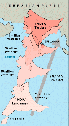
The geology of the Himalayas is a record of the most dramatic and visible creations of the immense mountain range formed by plate tectonic forces and sculpted by weathering and erosion. The Himalayas, which stretch over 2400 km between the Namcha Barwa syntaxis at the eastern end of the mountain range and the Nanga Parbat syntaxis at the western end, are the result of an ongoing orogeny — the collision of the continental crust of two tectonic plates, namely, the Indian Plate thrusting into the Eurasian Plate. The Himalaya-Tibet region supplies fresh water for more than one-fifth of the world population, and accounts for a quarter of the global sedimentary budget. Topographically, the belt has many superlatives: the highest rate of uplift (nearly 10 mm/year at Nanga Parbat), the highest relief (8848 m at Mt. Everest Chomolangma), among the highest erosion rates at 2–12 mm/yr, the source of some of the greatest rivers and the highest concentration of glac ... [...More Info...] [...Related Items...] OR: [Wikipedia] [Google] [Baidu] |


