|
Galilee Squadron
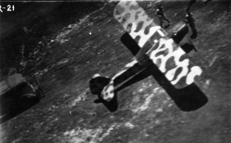
The Galilee Squadron ( he, טייסת הגליל, ''Tayeset Ha-Galil'') was an aerial unit established by the Yeshuv (Jewish residents of Palestine) during the 1948 Arab-Israeli War to assist the Jewish war effort in northern Palestine. Initially a part of the Sherut Avir, the aerial arm of the Haganah, it was absorbed into the fledgling Israeli Air Force (IAF) upon the latter's formation on 28 May 1948. The unit served throughout the war, following which it was amalgamated with several other units to form the IAF's 100 Squadron. History Formation and initial operations On 10 November 1947, with the impending decision on the partition of Palestine and the increasing likelihood of violent confrontations with their Arab neighbours, the leadership of the Yeshuv announced the establishment of the Sherut Avir (SA, Air Service). Operating a collection of light aircraft from Sde Dov outside Tel Aviv, the SA flew supply, communications, observation and medical evacuation flights, and ... [...More Info...] [...Related Items...] OR: [Wikipedia] [Google] [Baidu] |
Galilee Squadron Auster
Galilee (; he, הַגָּלִיל, hagGālīl; ar, الجليل, al-jalīl) is a region located in northern Israel and southern Lebanon. Galilee traditionally refers to the mountainous part, divided into Upper Galilee (, ; , ) and Lower Galilee (, ; , ). ''Galilee'' refers to all of the area that is north of the Mount Carmel-Mount Gilboa ridge and south of the east–west section of the Litani River. It extends from the Israeli coastal plain and the shores of the Mediterranean Sea with Acre in the west, to the Jordan Rift Valley to the east; and from the Litani in the north plus a piece bordering on the Golan Heights all the way to Dan at the base of Mount Hermon in the northeast, to Mount Carmel and Mount Gilboa in the south. This definition includes the plains of the Jezreel Valley north of Jenin and the Beth Shean Valley, the valley containing the Sea of Galilee, and the Hula Valley, although it usually does not include Haifa's immediate northern suburbs. By this defi ... [...More Info...] [...Related Items...] OR: [Wikipedia] [Google] [Baidu] |
Golani Brigade
The 1st "Golani" Brigade ( he, חֲטִיבַת גּוֹלָנִי) is an Israeli military infantry brigade that is subordinated to the 36th Division and traditionally associated with the Northern Command. It is one of the five infantry brigades of the regular Israel Defense Forces (IDF) (the others being the Paratroopers Brigade, the Nahal Brigade, the Givati Brigade and the Kfir Brigade). Its symbol is a green olive tree against a yellow background, with its soldiers wearing a brown beret. It is one of the most highly decorated infantry units in the IDF. The brigade consists of five battalions, including two which it kept from its inception (12th and 13th), one transferred from the Givati Brigade (51st). The brigade was formed on February 22, 1948, during the 1948 Arab–Israeli War, when the Levanoni Brigade in the Galilee split into the 1st Golani Brigade and the 2nd Carmeli Brigade. It has since participated in all of Israel's major wars and nearly all major operations, i ... [...More Info...] [...Related Items...] OR: [Wikipedia] [Google] [Baidu] |
Ramot Naftali
Ramot Naftali ( he, רָמוֹת נַפְתָּלִי) is a moshav in northern Israel. Located in the Upper Galilee near the Lebanese border, it falls under the jurisdiction of Mevo'ot HaHermon Regional Council. In it had a population of . The community is named "Ramot Naftali" (hills of Naftali) because it is located in the Naftali Mountains, which was originally in the land owned by the Tribe of Naphtali. History The community was founded in 1945 by a group of agricultural workers called "Bnei Peled", graduates of Mikveh Israel, who were sent by national agencies to guard the land and prepare it for agriculture. After the end of World War II arrived the first group of discharged soldiers from two groups, "Wingate" and "HaMitnadev", who organized for settlement before they had joined the army. The community was built around the , which was established together with the fortresses Birya and Hukok in 1945 as part of the defense of the British army in the north, in collaborati ... [...More Info...] [...Related Items...] OR: [Wikipedia] [Google] [Baidu] |
Moshav
A moshav ( he, מוֹשָׁב, plural ', lit. ''settlement, village'') is a type of Israeli town or settlement, in particular a type of cooperative agricultural community of individual farms pioneered by the Labour Zionists between 1904 and 1914, during what is known as the second wave of ''aliyah''. A resident or a member of a moshav can be called a "moshavnik" (). The moshavim are similar to kibbutzim with an emphasis on community labour. They were designed as part of the Zionist state-building programme following the green revolution Yishuv ("settlement") in the British Mandate of Palestine during the early 20th century, but in contrast to the collective farming kibbutzim, farms in a moshav tended to be individually owned but of fixed and equal size. Workers produced crops and other goods on their properties through individual or pooled labour with the profit and foodstuffs going to provide for themselves. Moshavim are governed by an elected council ( he, ועד, ''va'a ... [...More Info...] [...Related Items...] OR: [Wikipedia] [Google] [Baidu] |
Mandatory Palestine
Mandatory Palestine ( ar, فلسطين الانتدابية '; he, פָּלֶשְׂתִּינָה (א״י) ', where "E.Y." indicates ''’Eretz Yiśrā’ēl'', the Land of Israel) was a geopolitical entity established between 1920 and 1948 in the region of Palestine under the terms of the League of Nations Mandate for Palestine. During the First World War (1914–1918), an Arab uprising against Ottoman rule and the British Empire's Egyptian Expeditionary Force under General Edmund Allenby drove the Ottoman Turks out of the Levant during the Sinai and Palestine Campaign. The United Kingdom had agreed in the McMahon–Hussein Correspondence that it would honour Arab independence if the Arabs revolted against the Ottoman Turks, but the two sides had different interpretations of this agreement, and in the end, the United Kingdom and France divided the area under the Sykes–Picot Agreementan act of betrayal in the eyes of the Arabs. Further complicating the issue was t ... [...More Info...] [...Related Items...] OR: [Wikipedia] [Google] [Baidu] |
Samakh, Tiberias
Samakh ( ar, سمخ) was a Palestinian people, Palestinian Arab village at the south end of Lake Tiberias (the Sea of Galilee) in Ottoman Galilee and later Mandatory Palestine (now in Israel). It was the site of Battle of Samakh (1918), battle in 1918 during World War I. Between 1905 and 1948, the town was an important stop on the Jezreel Valley railway and Hejaz railway, being the last effective stop in the Mandatory Palestine, British Mandate of Palestine (the station at Al-Hamma, Tiberias, al-Hamma was geographically isolated). It had a population of 3,320 Arab Muslims and Arab Christians in 1945.Appendix B - Non-Jewish Population within the Boundaries Held by the Israel Defence Army on 1.5.49 - as on 1.4.45, in accordance with Government of Palestine, ''Village Statistics, April, 1945'', p7 The town's inhabitants fled after Haganah forces captured the town on 3 March 1948, and the remainder left in the wake of an assault by the Golani Brigade against the Military of Syria, ... [...More Info...] [...Related Items...] OR: [Wikipedia] [Google] [Baidu] |
Tegart Fort
A Tegart fort is a type of militarized police fort constructed throughout Palestine during the British Mandatory period, initiated as a measure against the 1936–1939 Arab Revolt. Etymology The forts are named after their designer, British police officer and engineer Sir Charles Tegart. In Israel, the name is often pronounced "Taggart". This is probably due to the transliteration of the name to Hebrew and then back to Latin alphabet, along with the translator's wrong assumption that the most common way of writing this anglicised Scottish surname has to be applied ("Taggart" is far more widespread than "Tegart"). History Mandate Palestine Sir Charles Tegart designed the forts in 1938 based on his experiences in the Indian insurgency. They were built of reinforced concrete with water systems that would allow them to withstand a month-long siege. Two types of forts were erected. Five structures were built to reinforce the so-called " Tegart's wall" of the northern border wit ... [...More Info...] [...Related Items...] OR: [Wikipedia] [Google] [Baidu] |
Battle Of Mishmar HaEmek
The Battle of Mishmar HaEmek was a ten-day battle fought from 4 to 15 April 1948 between the Arab Liberation Army ( Yarmouk Battalion) commanded by Fawzi al-Qawuqji and the Haganah (Palmach and HISH) commanded by Yitzhak Sadeh and Dan Laner. The battle begun when al-Qawuqji launched an attack against Mishmar HaEmek with the intent of taking the kibbutz, which was strategically placed beside the main road between Jenin and Haifa. In 1947 it had a population of 550. Battle On 4 April 1948, about 1,000 Arab Liberation Army (ALA) militiamen launched an attack on the kibbutz. They were initially opposed by 170 Jews and later, two companies of the Palmach, "less than 300 boys." The attack began with an artillery barrage from seven artillery pieces supplied by the Syrian Army, killing a young woman and her 11-month old baby at the nursery. This was the first time that artillery was used in the war. For five days, the Arab force shelled the village from a distance of 800 yards, ki ... [...More Info...] [...Related Items...] OR: [Wikipedia] [Google] [Baidu] |


