|
Garra, Balaghat
Garra is a village in Balaghat District of India, with a population of 4,097 (as of 2011 census). Geography The village is located 4.5 km east of the city of Balaghat, on the banks of the Wainganga river. Amenities The Garra Botanical Garden is a popular tourist attraction. Transport The Garra Railway Station serves the diesel multiple unit A diesel multiple unit or DMU is a multiple-unit train powered by on-board diesel engines. A DMU requires no separate locomotive, as the engines are incorporated into one or more of the carriages. Diesel-powered single-unit railcars are also ... (DEMU) train, which travels between Katangi and Gondia. Culture Poha, or "Garra-Poha", is a local dish made from flattened rice, Economy It has substantial textile makers. Leaders Garra's progression from a traditional village to a more developed area is largely credited to Dharmendra Trivedi (पप्पू त्रिवेदी), now known as the son of G ... [...More Info...] [...Related Items...] OR: [Wikipedia] [Google] [Baidu] |
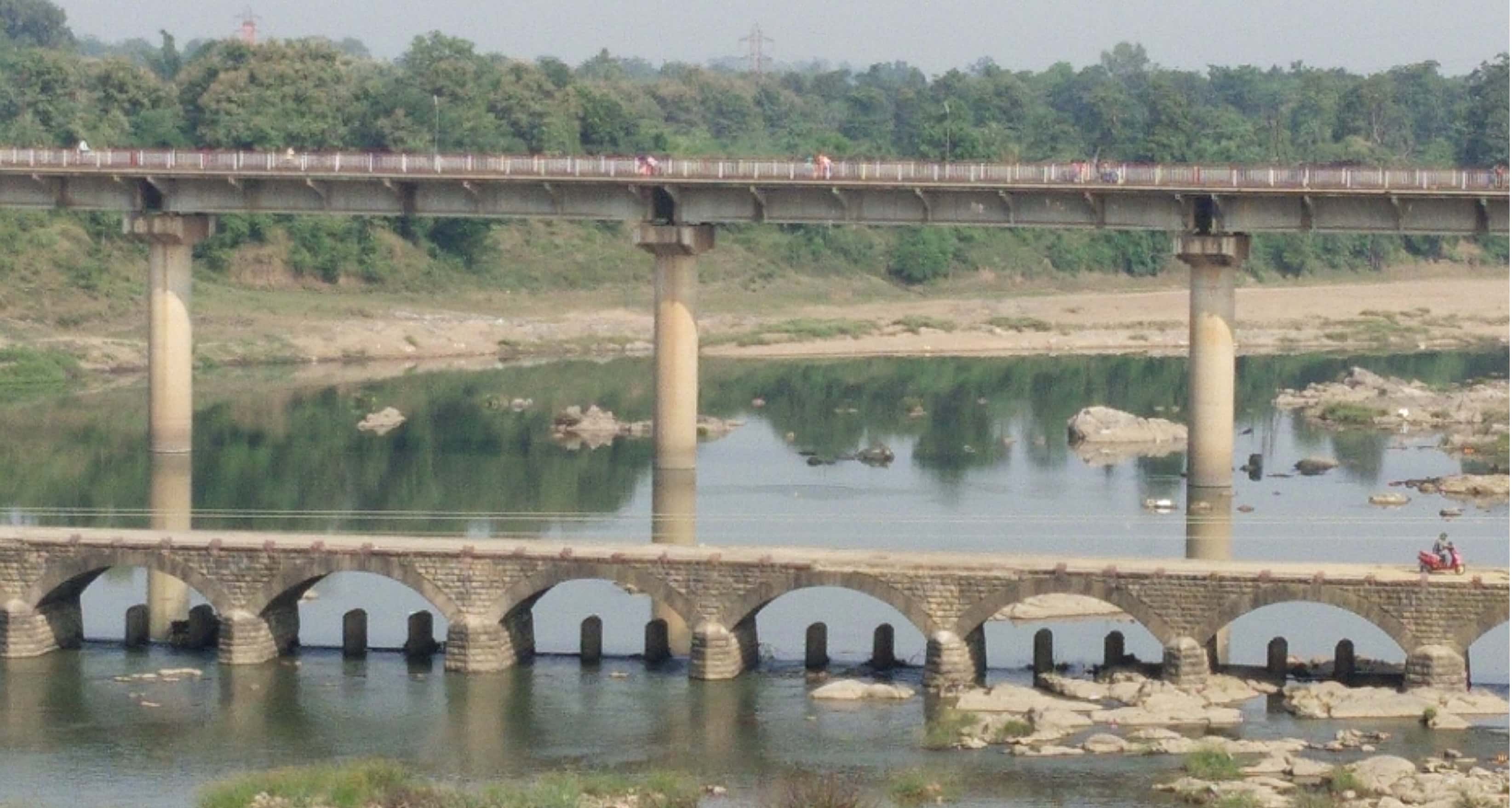
Wainganga Bridge In Garra Balaghat
The Wainganga is a river in India originating in the Mahadeo Hills in Mundara near the village Gopalganj in Seoni, Madhya Pradesh. It is a key tributary of the Godavari. The river flows south in a winding course through the states of Madhya Pradesh and Maharashtra, roughly . After joining the Wardha River, the united stream, which is known as the Pranahita River, empties into the Godavari River at Kaleshwaram, Telangana. Course The main stream of the Wainganga originates at Mahadev hills near Gopalganj, Seoni District, on the southern slopes of the Satpura Range of Madhya Pradesh. The river has developed extensive floodplains characterized by sweeping graceful meanders, low alluvial flats, and slip-off slopes. The river has high banks, which measure from to on either side. The northern part is surrounded by the Mahadeo hills and Satpura Range, with an average elevation of 625 m (2,051 ft) above sea level. The valley of the Wainganga River is forested an ... [...More Info...] [...Related Items...] OR: [Wikipedia] [Google] [Baidu] |
Balaghat District
Balaghat district is a district of Madhya Pradesh state in Central India. The town of Balaghat serves as its administrative headquarters. Balaghat is known for its tile factories, rice mills and forests. History At the beginning of the 18th century, the district was divided among two Gond kingdoms; the portion of the district west of the Wainganga was part of the Gond kingdom of Deogarh, while the eastern portion was part of the Garha-Mandla kingdom. The Deogarh kingdom was annexed by the Bhonsle Marathas of Nagpur in 1743, and shortly thereafter conquered all but the northern section of the district. This section, together with the rest of the Garha-Mandla kingdom, was annexed in 1781 to the Maratha province of Saugor, then under control of the Maratha Peshwa. In 1798 the Bhonsles also obtained the former Garha-Mandla territories. In 1818, at the conclusion of the Third Anglo-Maratha War, The Nagpur kingdom became a princely state of British India. In 1853, the Nagpur kingdo ... [...More Info...] [...Related Items...] OR: [Wikipedia] [Google] [Baidu] |
Poha (rice)
''Pohaa'', also known as ''pauwa'', ''sira'', ''chira'', ''aval'' or ''avalakki'', among many other names, is flattened rice originating from the Indian subcontinent. Rice is Parboiled_rice, parboiled before flattening so that it can be consumed with very little to no cooking. These flakes of rice swell when added to liquid, whether hot or cold, as they absorb water, milk or any other liquids. The thickness of the flakes varies from almost translucently thin (the more expensive varieties) to nearly four times thinner than a normal rice grain. This easily digestible form of raw rice is very popular across India, Nepal and Bangladesh, and is normally used to prepare snacks or light and easy fast food in a variety of Indian cuisine styles, some even for long-term consumption of a week or more. Flattened rice can be eaten raw by immersing it in plain water or milk, with salt and sugar to taste, or lightly fried in oil with nuts, raisins, cardamoms, and other spices. In North Indi ... [...More Info...] [...Related Items...] OR: [Wikipedia] [Google] [Baidu] |
Gondia
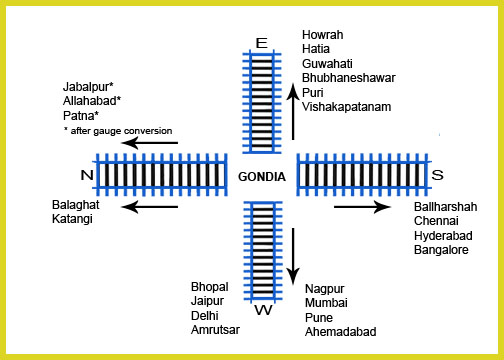
Gondia (also spelled Gondiya) is a city and municipal council in the Indian state of Maharashtra which serves the administrative headquarters of the eponymous administrative district. Gondia is also known as ''Rice City'' due to the abundance of rice mills in the area.Gondia Airport is only airport in district. Industry Adani Power Maharashtra Limited (APML), is 3 km away from Tirora on Tirora-Gondia state road. Coal is transported to Adani power, Ltd through a railway which is connected to Kachewani Railway Station. Water is being used from nearby weir constructed on Wainganga River. An 85.89% subsidiary of Adani Power Limited is implementing 3300 MW Thermal Power Station in Tirora. History The region is named after the Gondi people, an Adivasi group in central India. During British rule in India, the Great Famine of 1876–78 provided an opportunity for the construction of a metre-gauge rail link called the Nagpur Chhattisgarh Railway, connecting Nagpur with Rajnandgao ... [...More Info...] [...Related Items...] OR: [Wikipedia] [Google] [Baidu] |
Katangi
Katangi is a City and a Municipal Council, near City of Balaghat in Balaghat District in the Indian state of Madhya Pradesh. Geography Katangi is located at . It has an average elevation of 442 metres (1,450 feet). Transportation Katangi has connectivity by road to cities like Nagpur, Seoni, Tumsar, Bhandara and the district headquarters of Balaghat. Katangi also has railway connectivity. Katangi railway station is connected to Gondia via Balaghat by a broad-gauge network, Tirodi Railway Station is connected to Itwari (Nagpur) via Tumsar Road and Bhandara Road. Transportation for goods are Sagar (Katangi to Gondia), KGN Transport (Nagpur to Katangi) and New India Travels (Nagpur to Katangi). Demographics India census A census is the procedure of systematically acquiring, recording and calculating information about the members of a given population. This term is used mostly in connection with national population and housing censuses; other common censuses incl ... ... [...More Info...] [...Related Items...] OR: [Wikipedia] [Google] [Baidu] |
Diesel Multiple Unit
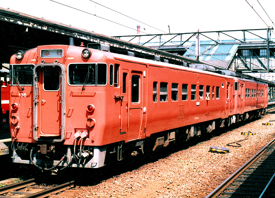
A diesel multiple unit or DMU is a multiple-unit train powered by on-board diesel engines. A DMU requires no separate locomotive, as the engines are incorporated into one or more of the carriages. Diesel-powered single-unit railcars are also generally classed as DMUs. Diesel-powered units may be further classified by their transmission type: diesel–mechanical DMMU, diesel–hydraulic DHMU, or diesel–electric DEMU. Design The diesel engine may be located above the frame in an engine bay or under the floor. Driving controls can be at both ends, on one end, or in a separate car. Types by transmission DMUs are usually classified by the method of transmitting motive power to their wheels. Diesel–mechanical In a diesel–mechanical multiple unit (DMMU), the rotating energy of the engine is transmitted via a gearbox and driveshaft directly to the wheels of the train, like a car. The transmissions can be shifted manually by the driver, as in the great majority of first-gen ... [...More Info...] [...Related Items...] OR: [Wikipedia] [Google] [Baidu] |
Wainganga River
The Wainganga is a river in India originating in the Mahadeo Hills in Mundara near the village Gopalganj in Seoni, Madhya Pradesh. It is a key tributary of the Godavari. The river flows south in a winding course through the states of Madhya Pradesh and Maharashtra, roughly . After joining the Wardha River, the united stream, which is known as the Pranahita River, empties into the Godavari River at Kaleshwaram, Telangana. Course The main stream of the Wainganga originates at Mahadev hills near Gopalganj, Seoni District, on the southern slopes of the Satpura Range of Madhya Pradesh. The river has developed extensive floodplains characterized by sweeping graceful meanders, low alluvial flats, and slip-off slopes. The river has high banks, which measure from to on either side. The northern part is surrounded by the Mahadeo hills and Satpura Range, with an average elevation of 625 m (2,051 ft) above sea level. The valley of the Wainganga River is forested and sparsely p ... [...More Info...] [...Related Items...] OR: [Wikipedia] [Google] [Baidu] |
Balaghat
Balaghat is a city and a municipality in Balaghat district, in the state of Madhya Pradesh, India. It is the administrative headquarters of Balaghat District. Wainganga River flows beside the town. Geography Balaghat is located at . It has an average elevation of 288 metres (944 feet). Demographics As of the 2011 Census of India The 2011 Census of India or the 15th Indian Census was conducted in two phases, house listing and population enumeration. The House listing phase began on 1 April 2010 and involved the collection of information about all buildings. Information ..., Balaghat had a population of 84,216. Males constitute 51% of the population and females 49%. 11% of the population is under 6 years of age. References Further reading {{Authority control Cities and towns in Balaghat district sv:Balaghat (distrikt) ... [...More Info...] [...Related Items...] OR: [Wikipedia] [Google] [Baidu] |
Village
A village is a clustered human settlement or community, larger than a hamlet but smaller than a town (although the word is often used to describe both hamlets and smaller towns), with a population typically ranging from a few hundred to a few thousand. Though villages are often located in rural areas, the term urban village is also applied to certain urban neighborhoods. Villages are normally permanent, with fixed dwellings; however, transient villages can occur. Further, the dwellings of a village are fairly close to one another, not scattered broadly over the landscape, as a dispersed settlement. In the past, villages were a usual form of community for societies that practice subsistence agriculture, and also for some non-agricultural societies. In Great Britain, a hamlet earned the right to be called a village when it built a church. [...More Info...] [...Related Items...] OR: [Wikipedia] [Google] [Baidu] |
States And Union Territories Of India
India is a federal union comprising 28 states and 8 union territories, with a total of 36 entities. The states and union territories are further subdivided into districts and smaller administrative divisions. History Pre-independence The Indian subcontinent has been ruled by many different ethnic groups throughout its history, each instituting their own policies of administrative division in the region. The British Raj mostly retained the administrative structure of the preceding Mughal Empire. India was divided into provinces (also called Presidencies), directly governed by the British, and princely states, which were nominally controlled by a local prince or raja loyal to the British Empire, which held ''de facto'' sovereignty ( suzerainty) over the princely states. 1947–1950 Between 1947 and 1950 the territories of the princely states were politically integrated into the Indian union. Most were merged into existing provinces; others were organised into ... [...More Info...] [...Related Items...] OR: [Wikipedia] [Google] [Baidu] |
Subscriber Trunk Dialling
Subscriber trunk dialling (STD), also known as subscriber toll dialing, is a telephone numbering plan feature and telecommunications technology for the dialling of trunk calls by telephone subscribers without the assistance from switchboard operators. Switching systems to enable automatic dialling of long distance calls by subscribers were introduced in the United Kingdom on 5 December 1958. The system used area codes that were based on the letters in a town's name. A ceremonial first call was made by Queen Elizabeth II from Bristol to Edinburgh. A similar service, built on crossbar equipment, using regionally structured numbering, rather than alphanumeric codes, was experimentally introduced by P&T in Ireland in 1957, with the first services being in Athlone. A full service was rolled out in 1958, initially to exchanges in Cork and then Dublin and its hinterland, and gradually to all areas with automatic exchanges. The term 'STD call' was once commonly used in the UK, Irela ... [...More Info...] [...Related Items...] OR: [Wikipedia] [Google] [Baidu] |


