|
GPS Software-defined Receiver
A software GNSS receiver is a Global Navigation Satellite System (GNSS) receiver that has been designed and implemented using software-defined radio. A GNSS receiver, in general, is an electronic device that receives and digitally processes the signals from a navigation satellite constellation in order to provide position, velocity and time (of the receiver). GNSS receivers have been traditionally implemented in hardware: a ''hardware GNSS receiver'' is conceived as a dedicated chip that has been designed and built (from the very beginning) with the only purpose of being a GNSS receiver. In a software GNSS receiver, all digital processing is performed by a general purpose microprocessor. In this approach, a small amount of inexpensive hardware is still needed, known as the '' frontend'', that digitizes the signal from the satellites. The microprocessor can then work on this ''raw'' digital stream to implement the GNSS functionality. Hardware vs. software GNSS receivers When co ... [...More Info...] [...Related Items...] OR: [Wikipedia] [Google] [Baidu] |
Satellite Navigation
A satellite navigation or satnav system is a system that uses satellites to provide autonomous geopositioning. A satellite navigation system with global coverage is termed global navigation satellite system (GNSS). , four global systems are operational: the United States's Global Positioning System (GPS), Russia's Global Navigation Satellite System (GLONASS), China's BeiDou Navigation Satellite System (BDS), and the European Union, European Union's Galileo (satellite navigation), Galileo. Two regional systems are operational: India's Indian Regional Navigation Satellite System, NavIC and Japan's Quasi-Zenith Satellite System, QZSS. ''Satellite-based augmentation systems'' (SBAS), designed to enhance the accuracy of GNSS, include Japan's Quasi-Zenith Satellite System (QZSS), India's GAGAN and the European EGNOS, all of them based on GPS. Previous iterations of the BeiDou navigation system and the present Indian Regional Navigation Satellite System (IRNSS), operationally known as ... [...More Info...] [...Related Items...] OR: [Wikipedia] [Google] [Baidu] |
USRP
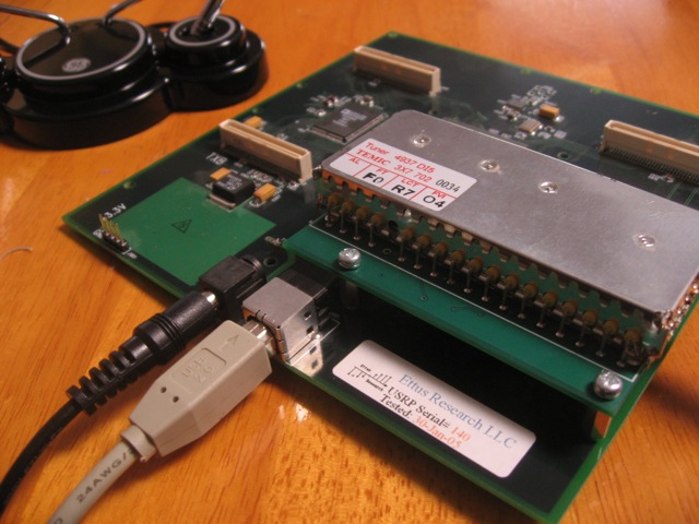
Universal Software Radio Peripheral (USRP) is a range of software-defined radios designed and sold by Ettus Research and its parent company, National Instruments. Developed by a team led by Matt Ettus, the USRP product family is commonly used by research labs, universities, and hobbyists. Most USRPs connect to a host computer through a high-speed link, which the host-based software uses to control the USRP hardware and transmit/receive data. Some USRP models also integrate the general functionality of a host computer with an embedded processor that allows the USRP device to operate in a stand-alone fashion. The USRP family was designed for accessibility, and many of the products are open source hardware. The board schematics for select USRP models are freely available for download; all USRP products are controlled with the open source UHD driver, which is free and open source software. USRPs are commonly used with the GNU Radio software suite to create complex software-define ... [...More Info...] [...Related Items...] OR: [Wikipedia] [Google] [Baidu] |
Software-defined Radio
Software-defined radio (SDR) is a radio communication system where components that conventionally have been implemented in analog hardware (e.g. mixers, filters, amplifiers, modulators/ demodulators, detectors, etc.) are instead implemented by means of software on a computer or embedded system. A basic SDR system may consist of a computer equipped with a sound card, or other analog-to-digital converter, preceded by some form of RF front end. Significant amounts of signal processing are handed over to the general-purpose processor, rather than being done in special-purpose hardware (electronic circuits). Such a design produces a radio which can receive and transmit widely different radio protocols (sometimes referred to as waveforms) based solely on the software used. Software radios have significant utility for the military and cell phone services, both of which must serve a wide variety of changing radio protocols in real time. In the long term, software-defined radios a ... [...More Info...] [...Related Items...] OR: [Wikipedia] [Google] [Baidu] |
Computing Comparisons
Computing is any goal-oriented activity requiring, benefiting from, or creating computing machinery. It includes the study and experimentation of algorithmic processes, and the development of both hardware and software. Computing has scientific, engineering, mathematical, technological, and social aspects. Major computing disciplines include computer engineering, computer science, cybersecurity, data science, information systems, information technology, and software engineering. The term ''computing'' is also synonymous with counting and calculating. In earlier times, it was used in reference to the action performed by mechanical computing machines, and before that, to human computers. History The history of computing is longer than the history of computing hardware and includes the history of methods intended for pen and paper (or for chalk and slate) with or without the aid of tables. Computing is intimately tied to the representation of numbers, though mathematic ... [...More Info...] [...Related Items...] OR: [Wikipedia] [Google] [Baidu] |
Cambridge University Press
Cambridge University Press was the university press of the University of Cambridge. Granted a letters patent by King Henry VIII in 1534, it was the oldest university press in the world. Cambridge University Press merged with Cambridge Assessment to form Cambridge University Press and Assessment under Queen Elizabeth II's approval in August 2021. With a global sales presence, publishing hubs, and offices in more than 40 countries, it published over 50,000 titles by authors from over 100 countries. Its publications include more than 420 academic journals, monographs, reference works, school and university textbooks, and English language teaching and learning publications. It also published Bibles, runs a bookshop in Cambridge, sells through Amazon, and has a conference venues business in Cambridge at the Pitt Building and the Sir Geoffrey Cass Sports and Social Centre. It also served as the King's Printer. Cambridge University Press, as part of the University of Cambridge, was a ... [...More Info...] [...Related Items...] OR: [Wikipedia] [Google] [Baidu] |
Artech House
Artech House (a.k.a. Artech House Publishers) is a publisher of professional scientific and engineering books. It is located in London, United Kingdom and Norwood, Massachusetts, United States. Artech House is a subsidiary of Horizon House Publications, Inc. Topics published Artech specializes in books about microwaves and radar, GNSS, power engineering, space engineering, electronic warfare, signal processing Signal processing is an electrical engineering subfield that focuses on analyzing, modifying and synthesizing ''signals'', such as audio signal processing, sound, image processing, images, Scalar potential, potential fields, Seismic tomograph ..., and other communications-related topics. References External links Artech House US website Artech House UK web site Book publishing companies of the United Kingdom Book publishing companies based in Massachusetts Companies based in Norfolk County, Massachusetts Companies based in the City of Westminster ... [...More Info...] [...Related Items...] OR: [Wikipedia] [Google] [Baidu] |
Python (programming Language)
Python is a high-level programming language, high-level, general-purpose programming language. Its design philosophy emphasizes code readability with the use of significant indentation. Python is type system#DYNAMIC, dynamically type-checked and garbage collection (computer science), garbage-collected. It supports multiple programming paradigms, including structured programming, structured (particularly procedural programming, procedural), object-oriented and functional programming. It is often described as a "batteries included" language due to its comprehensive standard library. Guido van Rossum began working on Python in the late 1980s as a successor to the ABC (programming language), ABC programming language, and he first released it in 1991 as Python 0.9.0. Python 2.0 was released in 2000. Python 3.0, released in 2008, was a major revision not completely backward-compatible with earlier versions. Python 2.7.18, released in 2020, was the last release of ... [...More Info...] [...Related Items...] OR: [Wikipedia] [Google] [Baidu] |
GNU Octave
GNU Octave is a scientific programming language for scientific computing and numerical computation. Octave helps in solving linear and nonlinear problems numerically, and for performing other numerical experiments using a language that is mostly compatible with MATLAB. It may also be used as a Batch processing, batch-oriented language. As part of the GNU Project, it is free software under the terms of the GNU General Public License. History The project was conceived around 1988. At first it was intended to be a companion to a chemical reactor design course. Full development was started by John W. Eaton in 1992. The first alpha release dates back to 4 January 1993 and on 17 February 1994 version 1.0 was released. Version 9.2.0 was released on 7 June 2024. The program is named after Octave Levenspiel, a former professor of the principal author. Levenspiel was known for his ability to perform quick back-of-the-envelope calculations. Development history Developments In addition ... [...More Info...] [...Related Items...] OR: [Wikipedia] [Google] [Baidu] |
RTCM
The Radio Technical Commission for Maritime Services (RTCM) is a non-profit international standards organization. Although started in 1947 as a U.S. government advisory committee, RTCM is now an independent organization supported by its member organizations from all over the world. In the United States, the Federal Communications Commission and U.S. Coast Guard use RTCM standards to specify systems such as radar, Emergency Position Indicating Radio Beacons, Electronic Navigation Charts and Maritime Survivor Locator Devices. Special committees RTCM Special Committees are formed to provide in-depth areas of concern to the RTCM membership, these special committees normally produce documents in the form of standards. Current special committees are * Special Committee (SC) 101 on Digital Selective Calling (DSC) * Joint Special Committee (SC) 101/110 on GPS Equipped Hand Held VHF Radios * Special Committee (SC) 104 on Differential Global Navigation Satellite Systems (DGNSS). Provi ... [...More Info...] [...Related Items...] OR: [Wikipedia] [Google] [Baidu] |
NMEA 0183
NMEA 0183 is a combined electrical and data specification for communication between marine electronics such as echo sounder, sonars, anemometer, gyrocompass, Self-steering gear, autopilot, GPS receivers and many other types of instruments. It has been defined and is controlled by the National Marine Electronics Association (NMEA). It replaces the earlier NMEA 0180 and NMEA 0182 standards. In leisure marine applications, it is slowly being phased out in favor of the newer NMEA 2000 standard, though NMEA 0183 remains the norm in commercial shipping. Details The electrical standard that is used is EIA-422, also known as RS-422, although most hardware with NMEA-0183 outputs are also able to drive a single EIA-232 port. The standard calls for optically isolated inputs. There is no requirement for isolation for the outputs. The NMEA 0183 standard uses a simple ASCII, serial communications protocol that defines how data are transmitted in a "sentence" from one "talker" to multiple "listen ... [...More Info...] [...Related Items...] OR: [Wikipedia] [Google] [Baidu] |
GeoJSON
GeoJSON is an open standard format designed for representing simple geographical features, along with their non-spatial attributes. It is based on the JSON format. The features include points (therefore addresses and locations), line strings (therefore streets, highways and boundaries), polygons (countries, provinces, tracts of land), and multi-part collections of these types. GeoJSON features are not limited to representing entities of the physical world only; mobile routing and navigation apps, for example, might describe their service coverage using GeoJSON. The GeoJSON format differs from other geographic information system standards in that it was written and is maintained not by a formal standards organization, but by an Internet working group of developers. A notable offspring of GeoJSON is TopoJSON, an extension of GeoJSON that encodes geospatial topology and that typically provides smaller file sizes. History The GeoJSON format working group and discussion were b ... [...More Info...] [...Related Items...] OR: [Wikipedia] [Google] [Baidu] |


