|
Föhr-Amrum
Föhr-Amrum is an ''Amt'' ("collective municipality") in the district of Nordfriesland, in Schleswig-Holstein, Germany. The ''Amt'' covers the islands Föhr and Amrum. Its seat is in Wyk auf Föhr. Föhr-Amrum was created on 1 January 2007 as a merger of the two ''Ämter'' Föhr-Land and Amrum and the formerly independent town of Wyk. Subdivision The ''Amt'' Föhr-Amrum consists of the following municipalities: # Alkersum # Borgsum # Dunsum # Midlum # Nebel #Nieblum #Norddorf # Oevenum # Oldsum # Süderende # Utersum # Witsum # Wittdün # Wrixum # Wyk auf Föhr (Fering, ''Fering'' North Frisian: ''Wik'', ''a Wik'', or ''Bi a Wik''; da, Vyk på Før) is the only town on Föhr, the second largest of the North Frisian Islands on the Germany, German coast of the North Sea. Like the entire island it belongs ... References External links Amt Föhr-Amrum {{DEFAULTSORT:Fohr-Amrum Ämter in Schleswig-Holstein ... [...More Info...] [...Related Items...] OR: [Wikipedia] [Google] [Baidu] |
Amrum
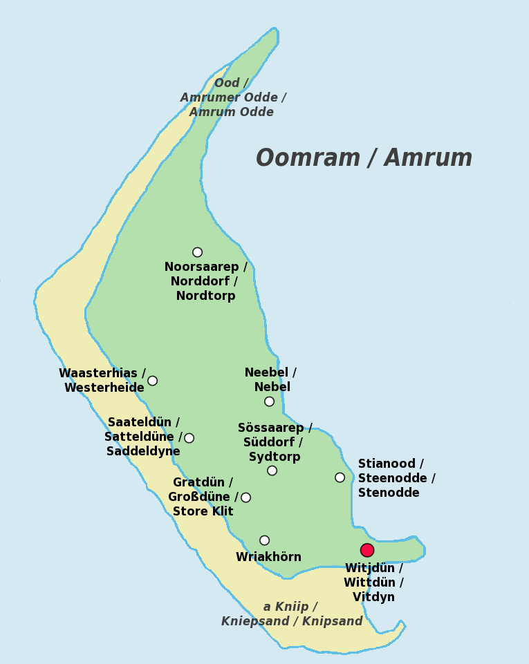
Amrum (; Öömrang, ''Öömrang'' North Frisian: ''Oomram'') is one of the North Frisian Islands on the Germany, German North Sea coast, south of Sylt and west of Föhr. It is part of the Nordfriesland district in the federal state of Schleswig-Holstein and has approximately 2,300 inhabitants. The island is made up of a sandy core of geestland and features an extended beach all along its west coast, facing the open North Sea. The east coast borders to mudflats of the Wadden Sea. Sand dunes are a characteristic part of Amrum's landscape, resulting in a vegetation that is largely made up of heath and shrubs. The island's only forest was planted in 1948. Amrum is a refuge for many species of birds and a number of marine mammals including the grey seal and harbour porpoise. Settlements on Amrum have been traced back to the Neolithic period when the area was still a part of the mainland of the Jutland peninsula. During the Middle Ages, Frisians, Frisian settlers arrived at Amrum and e ... [...More Info...] [...Related Items...] OR: [Wikipedia] [Google] [Baidu] |
Föhr
Föhr ( ''Fering'' North Frisian: ''Feer''; da, Før) is one of the North Frisian Islands on the German coast of the North Sea. It is part of the Nordfriesland district in the federal state of Schleswig-Holstein. Föhr is the second-largest North Sea island of Germany and a popular destination for tourists. A town and eleven distinct municipalities are located on the island. The climate is oceanic with moderate winters and relatively cool summers. Being a settlement area already in neolithic times, Föhr had been part of mainland North Frisia until 1362. Then the coastline was destroyed by a heavy storm flood known as Saint Marcellus's flood and several islands were formed, Föhr among them. The northern parts of Föhr consist of marshes while the southern parts consist of sandy geest. From the middle-ages until 1864, Föhr belonged to the Danish realm and to the Duchy of Schleswig, but was then transferred to Prussia as a result of the Second Schleswig War. Seafaring has long ... [...More Info...] [...Related Items...] OR: [Wikipedia] [Google] [Baidu] |
Wyk Auf Föhr
(Fering, ''Fering'' North Frisian: ''Wik'', ''a Wik'', or ''Bi a Wik''; da, Vyk på Før) is the only town on Föhr, the second largest of the North Frisian Islands on the Germany, German coast of the North Sea. Like the entire island it belongs to the Districts of Germany, district of Nordfriesland. Wyk includes the two minor town districts of Boldixum and Südstrand. Geography Wyk is situated on the southeastern edge of the island. About 4,500 inhabitants live there, but during the tourist seasons 20,000 or more people will stay there. It serves as a regional centre for the islands of Föhr and Amrum, providing shopping centres, doctors, a post office, etc. and it is the seat of the ''Amt'' Föhr-Amrum and the social care centre for the islands. The approximately 4,200 other inhabitants of Föhr proper live in other villages on the island. Wyk's major source of income is the tourism business. History and tourism In 1704, Wyk was granted the rights of a seaport, two years l ... [...More Info...] [...Related Items...] OR: [Wikipedia] [Google] [Baidu] |
Wrixum
Wrixum (; Fering: ''Wraksem'', Danish: ''Vriksum'') is a municipality on the island of Föhr, in the district of Nordfriesland, in Schleswig-Holstein, Germany. Geography and traffic Wrixum is one of eleven municipalities on Föhr and it is situated directly at the town limits of Wyk auf Föhr. The place enjoys a good bus service and features several bicycle rentals. Politics The ''WWG'' holds all nine seats of the municipal council since the elections of 2008. Arms Blazon: Or. In a hill vert over a wavy base argent, therein waves azure, a wind mill argent. In chief two oystercatchers proper, facing. Town twinning Wrixum has been twinned with Aub in Lower Franconia Lower Franconia (german: Unterfranken) is one of seven districts of Bavaria, Germany. The districts of Lower, Middle and Upper Franconia make up the region of Franconia. History After the founding of the Kingdom of Bavaria the state was totally ... since 1998. Economy There are many small enterprises in Wrixum ... [...More Info...] [...Related Items...] OR: [Wikipedia] [Google] [Baidu] |
Nebel, Germany
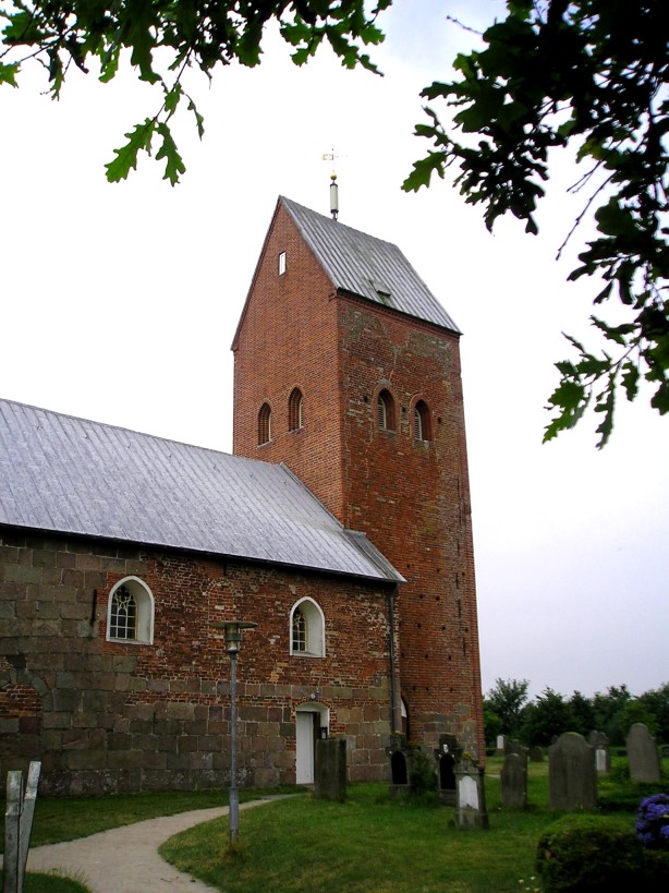
Nebel (Öömrang: ''Neebel'') is a municipality on the island of Amrum in the district of Nordfriesland in Schleswig-Holstein, Germany. Geography and traffic Until the end of 2006, Nebel was the seat of the ''Amt'' Amrum and as such it was the administrative centre of the island of Amrum. Süddorf (Öömrang: ''Sössaarep'') and Steenodde (''Stianood'') are minor districts of Nebel. The western part of the village is called Westerheide. Nebel is situated on the bus line from Wittdün to Norddorf. Until 1939 Nebel had a rail head station of Amrum's island railway. In Steenodde, there is a small harbour. History Nebel was presumably founded in the early 16th century. It is thought that the name is derived from the words ''nei'' and ''bel'', where the former means "new" and the latter is based on the ancient Danish term ''boli'', "settlement" (confer Niebüll and Nieblum). The church of St. Clement was built in 1236 and was standing between the villages of Norddorf and Süddo ... [...More Info...] [...Related Items...] OR: [Wikipedia] [Google] [Baidu] |
Wittdün
Wittdün (Öömrang: ''Witjdün'', da, Vitdyn) is a municipality on the island of Amrum in the district of Nordfriesland in Schleswig-Holstein, Germany. History Unlike the other villages of Amrum, Wittdün is a relatively young settlement. It was founded in 1890 as a seaside resort next to a new ferry port connecting the island to mainland Nordfriesland. The reason for founding this new village was the fear of many islanders of a decline of their Frisian culture due to the influx of tourists from the south. So, many Amrumers thought that concentrating the emerging seaside tourism in a single village would protect the local community from malign influences. Until December 31, 2006, the Wittdün municipality, together with Nebel and Norddorf formed the ''Amt'' Amrum. Politics Since the municipal elections of 2008, the ''Wittdüner Bürgerblock'' holds five seats of Wittdün's council, the CDU holds two. Economy Wittdün is a seaside resort, tourism is the main source o ... [...More Info...] [...Related Items...] OR: [Wikipedia] [Google] [Baidu] |
Witsum
Witsum ( da, Vitsum, North Frisian: ''Wiisem'') is a municipality on the island of Föhr, in the district of Nordfriesland, in Schleswig-Holstein, Germany. Geography Witsum is the smallest village on Föhr. From here one can see the Halligen and Amrum. Many seabirds (migratory birds among them) use the stream ''Godel'', the only "river" on Föhr, to hatch. The hamlet is situated on a geestland edge; there is no sea dike. A hill called ''Sylvert'' is located West of Witsum. There is a saying in the area that translates to: "What ''Mount Everest'' is for the world, the ''Sylvert'' is to our beloved island." History Witsum was first recorded in 1509. As a part of Westerland Föhr, it belonged to the Royal Enclaves of Denmark and thus was a direct part of the Danish crown while Osterland Föhr belonged to the duchy of Schleswig. Only when Denmark lost Schleswig to Prussia in the Second Schleswig War, Witsum became a part of Schleswig-Holstein. Witsum and the neighbouring village ... [...More Info...] [...Related Items...] OR: [Wikipedia] [Google] [Baidu] |
Utersum
Utersum ( Fering North Frisian: ''Ödersem'', da, Yttersum) is a municipality on the island of Föhr, in the district of Nordfriesland, in Schleswig-Holstein, Germany. The municipality includes the hamlet of Hedehusum. Geography The village is located between pine woods and dunes in the utmost southwest of Föhr, within the sight of the neighbouring islands of Amrum and Sylt. It is the smallest seaside resort on Föhr. In Utersum there is a sanitorium that specialises in diseases of the lung and in oncology and gynecology. In the lowlands along the river Godel, plants like salicornia and sea aster can be found. They thrive on salt marshes whose salt content is determined by abundant floodings with sea water. Sea birds like the pied avocet use to hatch there. A bus service links the place to the other villages on Föhr and to the town of Wyk. History Three preserved dolmens testify of settlements from as early as the Bronze Age. In the 17th and 18th century, whaling was an ... [...More Info...] [...Related Items...] OR: [Wikipedia] [Google] [Baidu] |
Süderende
Süderende ( Fering: ''Söleraanj'', da, Syderende) is a municipality on the island of Föhr in the district of Nordfriesland, in Schleswig-Holstein, Germany. History The place used to belong to Oldsum, being its southern edge. After Denmark's loss of Schleswig to Prussia in 1864 and the subsequent municipal reformation when Prussia eventually annexed Schleswig-Holstein in 1867, Süderende became independent. In the 17th century a private navigation school was established in Süderende by pastor Richardus Petri which was the first of its kind on the island. It improved the situation of the seafaring population considerably and soon other navigators opened own schools across Föhr. Although Petri lead the Süderende school successfully for many years he never sailed to sea himself. A census in 1787 showed that Süderende had 122 inhabitants, 27 of whom were seafarers. Language The common language among the locals is Fering. The language is being kept alive by being passed on t ... [...More Info...] [...Related Items...] OR: [Wikipedia] [Google] [Baidu] |
Oldsum
Oldsum (Fering: ''Olersem'') is a municipality on the island of Föhr, in the district of Nordfriesland, in Schleswig-Holstein, Germany. Geography The municipality of Oldsum consists of the three hamlets of Oldsum, Klintum (Fering: ''Klantem'') and Toftum (Fering: ''Taftem'') which are spread over some two kilometres along a main road. The population number about 600. The landscape is marked by well-preserved thatching, thatched farmhouses. Oldsum's landmark is an ancient thatched windmill whose antecessor presumably dates back to the year 1700. Though burned down 200 years later, it was rebuilt and subsequently was in use until 1954. Since 1972 the mill is exclusively used as a dwelling house. Oldsum is situated approximately two kilometres from the western shore of the island, the northern coastline is a little closer. Oldsum adjoins Süderende to the south, Dunsum to the southwest and Alkersum and Midlum, Schleswig-Holstein, Midlum to the east. History Oldsum was first record ... [...More Info...] [...Related Items...] OR: [Wikipedia] [Google] [Baidu] |
Oevenum
Oevenum ( Fering: ''Ööwenem'', da, Øvenum) is a municipality on the island of Föhr, in the district of Nordfriesland, in Schleswig-Holstein, Germany. History In 1796 23 houses in the neighbouring village of Nieblum were destroyed by a fire. Subsequently, a bell was installed atop Oevenum's school house to warn the people in case of fire. The bell was moreover rung in the morning and at noon and was also used as a means of alarm during storm surges. In 1882 Germany's first junior firefighters were recruited in Oevenum. Thus Oevenum's Junior Fire Service is presumably also the oldest of its kind in Europe. At the end of the Franco-Prussian War in 1871 an oak tree was planted in Oevenum to celebrate the subsequent peace. Homeland museum In a former barn, a homeland museum has been established which documents life in general and the agricultural development on Föhr. You will also find information on navigating, the construction of sea dikes Dyke (UK) or dike (US) may refer t ... [...More Info...] [...Related Items...] OR: [Wikipedia] [Google] [Baidu] |
Norddorf
Norddorf auf Amrum (Öömrang: ''Noorsaarep üüb Oomram'', da, Nordtorp) is a municipality on the island of Amrum, in the district of Nordfriesland, in Schleswig-Holstein, Germany. History Together with Süddorf, Norddorf is the oldest village of the island. In 1890, Friedrich von Bodelschwingh founded a number of seaside hospices in Norddorf proper and north of it. Due to this, the place developed into a seaside resort. In 1925, great parts of the village were destroyed by a fire, so today's view of the village is dominated by mostly modern houses without thatched roofs. Today, the hospices now serve other purposes or no longer exist. During the early 20th century, the so-called ''Kniephafen'' harbour existed north of Norddorf at Amrum's vast ''Kniepsand'' beach. The port was navigable by greater vessels and it most of all served the nautical traffic between Amrum and the port of Hörnum on the neighbouring island of Sylt. The ''Kniephafen'' was linked to the network of A ... [...More Info...] [...Related Items...] OR: [Wikipedia] [Google] [Baidu] |

.jpg)


