|
Friendship Highway (Tibet)
There are several highways sometimes known as Friendship highways. Note that the "friendship" name may not in all cases necessarily be the current official name or common name. * China-Laos Friendship Highway, 1963 (Chinese 中老友谊公路) * China-Nepal Friendship Highway, 1967 (Chinese 中尼友谊公路), highway connecting the Chinese Tibet Autonomous Region with Nepal *China-Pakistan Friendship Highway (Chinese 中巴友誼公路), better known as the Karakoram Highway *China-Vietnam Friendship Highway (Chinese 中越友谊公路) *Mittraphap Road (Thailand Route 2), literally "Friendship Road" * Khmer-American Friendship Highway (National highway 4), Cambodia *Philippine-Japan Friendship Highway The Pan-Philippine Highway, also known as the Maharlika Highway ( tl, Daang Maharlika; ceb, Dalang Halangdon), is a network of roads, expressways, bridges, and ferry services that connect the islands of Luzon, Samar, Leyte, and Mindanao in t ..., Philippines * Bangladesh-Myanm ... [...More Info...] [...Related Items...] OR: [Wikipedia] [Google] [Baidu] |
Chinese Road
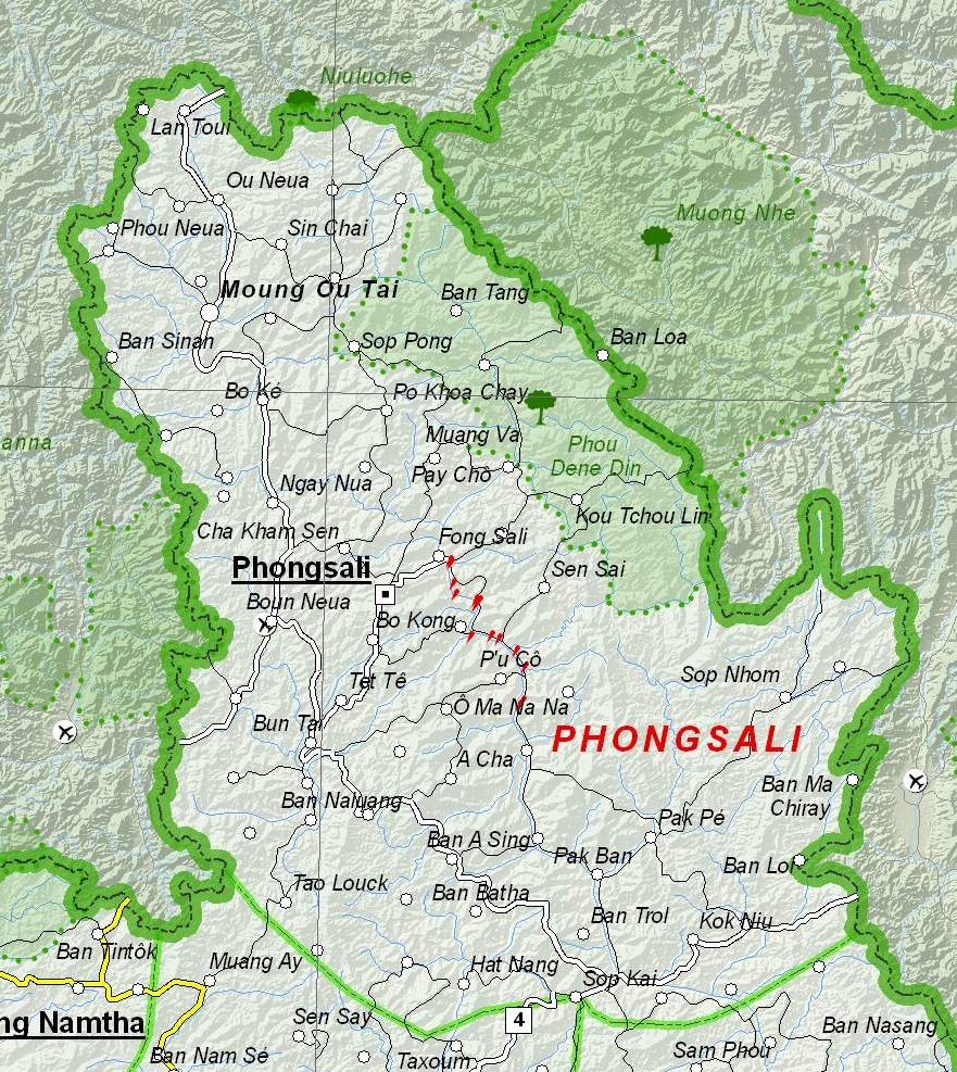
The Chinese Road (or The Chinese Roads) were a series of highways built as a foreign aid project by the People's Republic of China (PRC) in northern Laos, beginning in 1962. The first new road was built from Mengla, Yunnan Province, PRC to Phongsali, Laos; it was completed on 25 May 1963. The next major road built was Route 46, begun in the 1966 dry season and stretching from the southern tip of Yunnan Province southward toward the border of the Kingdom of Thailand. As 25,000 Chinese troops and 400 antiaircraft guns came to be posted to defend Route 46, and Thai support of American war efforts in both the Laotian Civil War and the Vietnam War became widely known, there was uneasiness among both Thai and American intelligence communities concerning Communist China's intents in constructing the all-weather highway. American interest in the new road extended up to the White House. Central Intelligence Agency (CIA) trained guerrillas spied on Route 46, and there was an attempt to blo ... [...More Info...] [...Related Items...] OR: [Wikipedia] [Google] [Baidu] |
Tibet Autonomous Region
The Tibet Autonomous Region or Xizang Autonomous Region, often shortened to Tibet or Xizang, is a Provinces of China, province-level Autonomous regions of China, autonomous region of the China, People's Republic of China in Southwest China. It was overlayed on the traditional Tibetan regions of Ü-Tsang and Kham. It was formally established in 1965 to replace the Tibet Area (administrative division), Tibet Area, the former Administrative divisions of China, administrative division of the People's Republic of China (PRC) established after the annexation of Tibet by the People's Republic of China, annexation of Tibet. The establishment was about five years after the 1959 Tibetan uprising and the dismissal of the Kashag, and about 13 years after the original annexation. The current borders of the Tibet Autonomous Region were generally established in the 18th century and include about half of historic Tibet, or the Tibet, ethno-cultural Tibet. The Tibet Autonomous Region spans ov ... [...More Info...] [...Related Items...] OR: [Wikipedia] [Google] [Baidu] |
Karakoram Highway
The Karakoram Highway ( ur, , translit=śāhirāh qarāquram; known by its initials KKH, also known as N-35 or National Highway 35 ( ur, ) or the China-Pakistan Friendship Highway) is a national highway which extends from Hasan Abdal in the Punjab province of Pakistan to the Khunjerab Pass in Gilgit-Baltistan, where it crosses into China and becomes China National Highway 314. The highway connects the Pakistani provinces of Punjab and Khyber Pakhtunkhwa plus Gilgit-Baltistan with China's Xinjiang Uyghur Autonomous Region. The highway is a popular tourist attraction and is one of the highest paved roads in the world, passing through the Karakoram mountain range, at at maximum elevation of near Khunjerab Pass. Due to its high elevation and the difficult conditions under which it was constructed, it is often referred to as the Eighth Wonder of the World. The highway is also a part of the Asian Highway AH4. History The Karakoram Highway, also known as the Friendship ... [...More Info...] [...Related Items...] OR: [Wikipedia] [Google] [Baidu] |
Mittraphap Road
Mittraphap Road (, , ) or Highway 2 (, ) is one of the four primary highways in Thailand, along with Phahonyothin Road (Highway 1), Sukhumvit Road (Highway 3), and Phetkasem Road (Highway 4). It runs from Saraburi to Nong Khai. The road was originally built from Khorat to Nong Khai by the United States in 1955–1957 at a cost of US$20 million to supply its northeastern military bases. It is the first highway in Thailand to meet international standards, and the first highway in Thailand to use both asphalt and concrete. It received the name "Thanon Mittraphap" on 20 February 1957. The name literally means "Friendship Road". It is the main road that connects Isan (northeastern Thailand) across the Dong Phaya Yen Range. The highway begins at Saraburi, Phahonyothin Road (Highway 1) junction. It passes through the provinces of Nakhon Ratchasima, Khon Kaen, Udon Thani, and ends in Nong Khai, where it links with the Thai-Lao Friendship Bridge to Laos Laos (, ''Lāo'' )), offi ... [...More Info...] [...Related Items...] OR: [Wikipedia] [Google] [Baidu] |
Philippine-Japan Friendship Highway
The Pan-Philippine Highway, also known as the Maharlika Highway ( tl, Daang Maharlika; ceb, Dalang Halangdon), is a network of roads, expressways, bridges, and ferry services that connect the islands of Luzon, Samar, Leyte, and Mindanao in the Philippines, serving as the country's principal transport backbone. Measuring long excluding sea routes, it is the longest highway in the Philippines that forms the country's north–south backbone component of National Route 1 (N1) of the Philippine highway network. The entire highway is designated as Asian Highway 26 (AH26) of the Asian Highway Network. The northern terminus of the highway is in Laoag and the southern terminus is in Zamboanga City. History The Pan-Philippine Highway System was an infrastructure program of President Diosdado Macapagal as a first priority project for the improvement and expansion of Philippine highway and land transport networks. It was stated in his final State of the Nation Address in 1965 that ... [...More Info...] [...Related Items...] OR: [Wikipedia] [Google] [Baidu] |


