|
Foxup
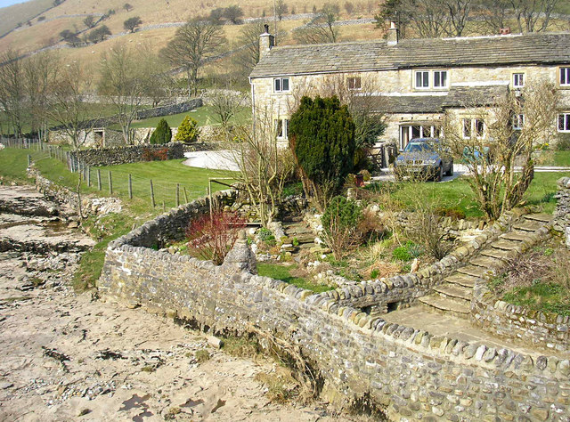
Foxup is a hamlet (place), hamlet in the Yorkshire Dales in the Craven District, Craven district of North Yorkshire, England. The hamlet is near Halton Gill and Litton, North Yorkshire, Litton and is north west of Grassington. Foxup is in the civil parish of Halton Gill. The source of the River Skirfare starts here at the confluence of Foxup Beck and Cosh Beck. The bridge over Foxup Beck in the hamlet is 17th century and was listed Grade II in 1958. The village marks the end of the main road through Littondale. There are a number of Public Footpaths and Bridleways in and around the village. The area is a mixture of sheep and beef farming. Dairy farming is harder than in comparison to other locations further down the valley because of the limitations on grass types and transportation of dairy produce out of the area. The name Foxup is of Old English origin, meaning "fox valley", from ''fox'' and ''hop'' "small enclosed valley", apparently in contrast to the adjacent valley of ... [...More Info...] [...Related Items...] OR: [Wikipedia] [Google] [Baidu] |
River Skirfare
River Skirfare is a small river in North Yorkshire, England, that flows through Littondale and ends where it joins the larger River Wharfe. The source is the confluence of Foxup Beck and Cosh Beck at the hamlet of Foxup. The name is of Old Norse origin, from ''skírr'' "bright" or "clear" and ''far'' "river-course". Course The source of the river is the confluence of Foxup Beck and Cosh Beck at the hamlet of Foxup. To the east bank lays Hawkswick Moor and on the west bank lays Darnbrook Fell, Hawkswick Clowder and Pen-y-ghent Fell. The river meanders consistently south-east for approximately to the confluence with the River Wharfe. Natural history The flora and fauna found along the river are similar to that found along the nearby River Wharfe. Economy The economy of the area around the river are similar to that found along the nearby River Wharfe. Lists Tributaries From the source of the river: * Halton Gill Beck * Newshot Gill * Hesleden Beck * Potts Beck * F ... [...More Info...] [...Related Items...] OR: [Wikipedia] [Google] [Baidu] |
Littondale
Littondale is a dale in the Craven district of the non-metropolitan county of North Yorkshire, England. It comprises the main settlements of Hawkswick, Arncliffe, Litton, Foxup and Halton Gill, and farmhouses that date from the 17th century. The main waterway in the dale is the River Skirfare which is fed by many small gills and becks. The dale, first recorded by name as ''Littundale'' in 1198, is one of the few dales named from its main settlement rather than its river (Wensleydale is the best known example). Historically the dale was also known as Amerdale. The village of Arncliffe was the original setting for the TV series ''Emmerdale'', which is believed to take its name from Amerdale. Geography Littondale is a side dale to the west of Wharfedale and follows the River Skirfare. The nature of the dale and its characteristic smooth form was the result of many ice ages, especially the one 20,000 years ago. As the glacier for that age receded it left retreat moraine, an exam ... [...More Info...] [...Related Items...] OR: [Wikipedia] [Google] [Baidu] |
Halton Gill
Halton Gill is a hamlet and civil parish in Littondale in the Yorkshire Dales in North Yorkshire, England. It is situated up Littondale from Litton. A minor road leads south west to Silverdale and Stainforth in Ribblesdale. The name of the hamlet was recorded in 1457 as Haltonghyll. The name derives from a combination of Old English and Old Norse and means the nook of land (or ravine) with a small valley by a farmstead and a stream. The civil parish includes the hamlets of Foxup and Hesleden. To the south the parish rises to the summits of Plover Hill and Pen-y-Ghent. The population of the civil parish was estimated at 60 in 2012. From Halton Gill there is a bridleway over the Horse Head Pass to the north east to Yockenthwaite in Langstrothdale. This path was used by the priest from Hubberholme to reach the small chapel in Halton Gill. To the west paths lead to the summit of Pen-y-ghent via Plover Hill. The 2010 Sainsbury's Christmas advert with celebrity chef, Jamie O ... [...More Info...] [...Related Items...] OR: [Wikipedia] [Google] [Baidu] |
Craven District
Craven is a local government district of North Yorkshire, England centred on the market town of Skipton. In 1974, Craven District was formed as the merger of Skipton urban district, Settle Rural District and most of Skipton Rural District, all in the West Riding of Yorkshire. The population of the Local Authority area at the 2011 Census was 55,409. It comprises the upper reaches of Airedale, Wharfedale, Ribblesdale, and includes most of the Aire Gap and Craven Basin. The name Craven is much older than the modern district, and encompassed a larger area. This history is also reflected in the way the term is still commonly used, for example by the Church of England. History ''Craven'' has been the name of this district throughout recorded history. Note: Select the Thorton in Craven entry. Its extent in the 11th century can be deduced from The Domesday Book but its boundaries now differ according to whether considering administration, taxation or religion. Toponymy The deri ... [...More Info...] [...Related Items...] OR: [Wikipedia] [Google] [Baidu] |
North Yorkshire
North Yorkshire is the largest ceremonial counties of England, ceremonial county (lieutenancy area) in England, covering an area of . Around 40% of the county is covered by National parks of the United Kingdom, national parks, including most of the Yorkshire Dales and the North York Moors. It is one of four counties in England to hold the name Yorkshire; the three other counties are the East Riding of Yorkshire, South Yorkshire and West Yorkshire. North Yorkshire may also refer to a non-metropolitan county, which covers most of the ceremonial county's area () and population (a mid-2016 estimate by the Office for National Statistics, ONS of 602,300), and is administered by North Yorkshire County Council. The non-metropolitan county does not include four areas of the ceremonial county: the City of York, Middlesbrough, Redcar and Cleveland and the southern part of the Borough of Stockton-on-Tees, which are all administered by Unitary authorities of England, unitary authorities. ... [...More Info...] [...Related Items...] OR: [Wikipedia] [Google] [Baidu] |
Skipton And Ripon (UK Parliament Constituency)
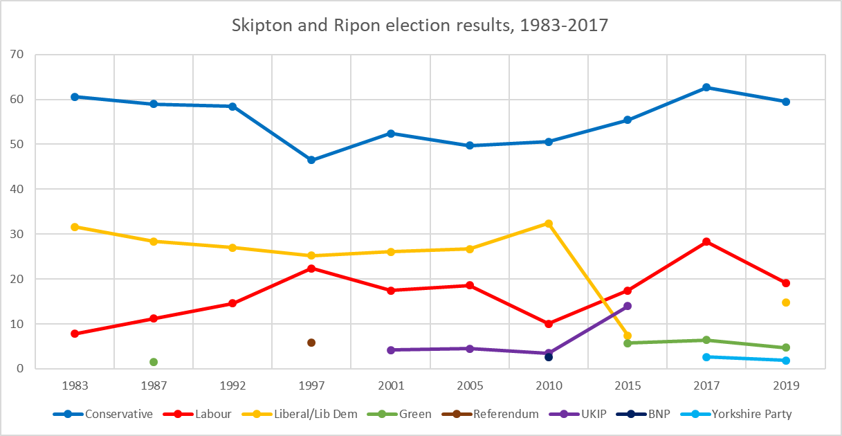
Skipton and Ripon is a constituency in North Yorkshire represented in the House of Commons of the UK Parliament since 2010 by Julian Smith, a Conservative. Constituency profile The constituency covers a mainly rural area of the Yorkshire Dales. The largest settlements are the town of Skipton and the city of Ripon. Smaller towns in the constituency are Bentham, Settle, Pateley Bridge and Masham. It is one of the safest seats in England, formed on an area with a long history of Conservative representation and with a large majority of its electorate having in the last election voted Conservative. It was also the constituency in 1992 that when declared, saw the Conservatives gain the 4th straight majority since 1979 and John Major re-elected as Prime Minister. At 1.6%, Skipton and Ripon had significantly lower than national average unemployment (3.8%) in November 2012. Boundaries 1983–1997: The District of Craven, and the Borough of Harrogate wards of Almscliffe, Bishop ... [...More Info...] [...Related Items...] OR: [Wikipedia] [Google] [Baidu] |
Hamlet (place)
A hamlet is a human settlement that is smaller than a town or village. Its size relative to a Parish (administrative division), parish can depend on the administration and region. A hamlet may be considered to be a smaller settlement or subdivision or satellite entity to a larger settlement. The word and concept of a hamlet has roots in the Anglo-Norman settlement of England, where the old French ' came to apply to small human settlements. Etymology The word comes from Anglo-Norman language, Anglo-Norman ', corresponding to Old French ', the diminutive of Old French ' meaning a little village. This, in turn, is a diminutive of Old French ', possibly borrowed from (West Germanic languages, West Germanic) Franconian languages. Compare with modern French ', Dutch language, Dutch ', Frisian languages, Frisian ', German ', Old English ' and Modern English ''home''. By country Afghanistan In Afghanistan, the counterpart of the hamlet is the Qila, qala (Dari language, Dari: ... [...More Info...] [...Related Items...] OR: [Wikipedia] [Google] [Baidu] |
Yorkshire Dales
The Yorkshire Dales is an upland area of the Pennines in the Historic counties of England, historic county of Yorkshire, England, most of it in the Yorkshire Dales National Park created in 1954. The Dales comprise river valleys and the hills rising from the Vale of York westwards to the hilltops of the Pennine Drainage divide, watershed. In Ribblesdale, Dentdale and Garsdale, the area extends westwards across the watershed, but most of the valleys drain eastwards to the Vale of York, into the River Ouse, Yorkshire, Ouse and the Humber. The extensive limestone cave systems are a major area for caving in the UK and numerous walking trails run through the hills and dales. Etymology The word ''Dale (landform), dale'', like ''dell'', is derived from the Old English word ''dæl''. It has cognates in the North Germanic languages, Nordic/Germanic languages, Germanic words for valley (''dal'', ''tal''), and occurs in valley names across Yorkshire and Northern England. Usage here may have ... [...More Info...] [...Related Items...] OR: [Wikipedia] [Google] [Baidu] |
Litton, North Yorkshire
Litton is a village and civil parish in Littondale in the Yorkshire Dales in England. It lies in the Craven District of North Yorkshire, up Littondale from Arncliffe. From Litton a footpath leads over the fells to the north east to Buckden in Wharfedale. The population of the civil parish was estimated at 70 in 2015. The centre of the village is an old public house, the Queens Arms, that dates back to the 17th century. Associated with the Queens Arms since 2003 is the Lamb Brewing Company (previously the Litton Brewery) that brews Litton Ale. Litton was mentioned in the Domesday Book of 1086 (as ''Litone''). The name probably comes from the Old English ''hlið'' "hillside" and ''tūn'' "farmstead". Litton was historically a township in the ancient parish of Arncliffe, part of Staincliffe Wapentake in the West Riding of Yorkshire. Litton became a separate civil parish in 1866. The parish was transferred to the new county of North Yorkshire North Yorkshire is the ... [...More Info...] [...Related Items...] OR: [Wikipedia] [Google] [Baidu] |
Old English
Old English (, ), or Anglo-Saxon, is the earliest recorded form of the English language, spoken in England and southern and eastern Scotland in the early Middle Ages. It was brought to Great Britain by Anglo-Saxon settlement of Britain, Anglo-Saxon settlers in the mid-5th century, and the first Old English literature, Old English literary works date from the mid-7th century. After the Norman conquest of 1066, English was replaced, for a time, by Anglo-Norman language, Anglo-Norman (a langues d'oïl, relative of French) as the language of the upper classes. This is regarded as marking the end of the Old English era, since during this period the English language was heavily influenced by Anglo-Norman, developing into a phase known now as Middle English in England and Early Scots in Scotland. Old English developed from a set of Anglo-Frisian languages, Anglo-Frisian or Ingvaeonic dialects originally spoken by Germanic peoples, Germanic tribes traditionally known as the Angles, Sa ... [...More Info...] [...Related Items...] OR: [Wikipedia] [Google] [Baidu] |


