|
Florida's 17th Congressional District
Florida's 17th congressional district is an electoral district for the U.S. Congress, located in Southwest Florida. In the 2020 redistricting cycle, the district was shrunk to only include the coastal counties of Sarasota and Charlotte as well as northeastern Lee County, including most of Lehigh Acres. Other inland counties which were previously in the district were instead redistricted into the new 18th district. The 17th district was created as a result of the redistricting cycle after the 1980 Census. From 2003 to 2013 it was located in South Florida, and was a majority African American district. It included the southern parts of Broward County and the eastern parts of Miami-Dade County. Included within the district were Pembroke Pines, Hollywood, Miramar, and North Miami. Most of this district is now the 24th District. After the 2010 census and its corresponding redistricting cycle, the district included portions of the previous 12th and 16th Districts. Most of the ... [...More Info...] [...Related Items...] OR: [Wikipedia] [Google] [Baidu] |
Florida's 17th Congressional District (since 2023)
Florida's 17th congressional district is an congressional district, electoral district for the U.S. Congress, located in Southwest Florida. In the 2020 United States redistricting cycle, 2020 redistricting cycle, the district was shrunk to only include the coastal counties of Sarasota County, Florida, Sarasota and Charlotte County, Florida, Charlotte as well as northeastern Lee County, Florida, Lee County, including most of Lehigh Acres, Florida, Lehigh Acres. Other inland counties which were previously in the district were instead redistricted into the new Florida's 18th congressional district, 18th district. The 17th district was created as a result of the 1980 United States redistricting cycle, redistricting cycle after the 1980 United States census, 1980 census. From 2003 to 2013 it was located in South Florida, and was a majority African American (U.S. Census), African American district. It included the southern parts of Broward County, Florida, Broward County and the easte ... [...More Info...] [...Related Items...] OR: [Wikipedia] [Google] [Baidu] |
Hollywood, Florida
Hollywood is a city in southern Broward County, Florida, United States, located between Fort Lauderdale and Miami. As of July 1, 2019, Hollywood had a population of 154,817. Founded in 1925, the city grew rapidly in the 1950s and 1960s, and is now the 12th-largest city in Florida. Hollywood is a principal city of the Miami metropolitan area, which was home to an estimated 6,012,331 people at the 2015 census. The average temperature is between . History In 1920, Joseph Young arrived in South Florida to create his own "Dream City in Florida". His vision included the beaches of the Atlantic Ocean stretching westward with man-made lakes, infrastructure, roads, and the Intracoastal Waterway. He wanted to include large parks, schools, churches, and golf courses; these were all industries and activities that were very important to Young's life. After Young spent millions of dollars on the construction of the city, he was elected as the first mayor in 1925. This new town quickly became h ... [...More Info...] [...Related Items...] OR: [Wikipedia] [Google] [Baidu] |
North Port, Florida
North Port is a city located in Sarasota County, Florida, United States. The population was 74,793 at the 2020 US Census. It is part of the North Port–Bradenton–Sarasota Metropolitan Statistical Area. It was originally developed by General Development Corporation as the northern / Sarasota County portion of its Port Charlotte development, the other portion located in the adjacent Charlotte County. GDC dubbed the city ''North Port Charlotte'', and it was incorporated under that name through a special act of the Florida Legislature in 1959. By referendum in 1974, the city's residents approved a change to its name as ''North Port'', dropping ''Charlotte'' from its name to proclaim the city as a separate identity. It is home to the Little Salt Spring, an archaeological and paleontological site owned by the University of Miami. History Archaeological digs at the Little Salt Spring show that what is now North Port was inhabited by pre-Columbian Native Americans. Evidenc ... [...More Info...] [...Related Items...] OR: [Wikipedia] [Google] [Baidu] |
Polk County, Florida
Polk County is located in the central portion of the U.S. state of Florida. The county population was 725,046, as of the 2020 census. Its county seat is Bartow, and its largest city is Lakeland. Polk County comprises the Lakeland–Winter Haven Metropolitan Statistical Area. This MSA is the 81st-most populous metropolitan statistical area and the 89th-most populous primary statistical area of the United States as of July 1, 2012. The center of population of Florida is located in Polk County, near the city of Lake Wales. Polk County is home to one public university, one state college, and four private universities. History Early history The first people to inhabit the area now called Polk County were the Paleoindians who arrived in Florida at least 12,000 years ago, late in the last ice age. With large amounts of water locked up in continental ice caps, the sea level was more than lower than at present. The Florida peninsula was twice as wide as it is today, and Flor ... [...More Info...] [...Related Items...] OR: [Wikipedia] [Google] [Baidu] |
Okeechobee County, Florida
Okeechobee County () is a county located in the Florida Heartland region of the state of Florida. As of the 2020 census, the population was 39,644. The county seat is Okeechobee. Okeechobee County comprises the Okeechobee, FL Micropolitan Statistical Area, which is included in the Miami-Fort Lauderdale-Port St. Lucie, FL Combined Statistical Area. History Okeechobee County was incorporated in 1917. It was named for Lake Okeechobee, which was itself named for the Seminole Indian words ''okee'' (water) and ''chobee'' (big). Historic buildings Historic buildings in Okeechobee County include: * First United Methodist Church, 1924 * Freedman-Raulerson House, 1923 * Okeechobee County Courthouse, 1926 Geography According to the U.S. Census Bureau, the county has a total area of , of which is land and (13.8%) is water. Adjacent counties * Indian River County - northeast * Martin County - east * St. Lucie County - east * Glades County - southwest * Hendry County - sout ... [...More Info...] [...Related Items...] OR: [Wikipedia] [Google] [Baidu] |
Highlands County, Florida
Highlands County is a County (United States), county located in the Florida Heartland region of the U.S. state of Florida. As of the 2020 United States census, 2020 census, the population was 101,235. Its county seat is Sebring, Florida, Sebring. Highlands County comprises the Sebring-Avon Park, FL Metropolitan Statistical Area. History Highlands County was created in 1921 along with Charlotte County, Florida, Charlotte, Glades County, Florida, Glades, and Hardee County, Florida, Hardee, when they were separated from DeSoto County, Florida, DeSoto County. It was named for the terrain of the county. It boasted the fifth-oldest population in America in 2012. Geography According to the U.S. Census Bureau, the county has a total area of , of which is land and (8.1%) is water. In area, it is the 14th largest county in Florida. Highlands County is bounded on the east by the Kissimmee River. Lake Istokpoga, the largest lake in the county, is connected to the Kissimmee River by two ... [...More Info...] [...Related Items...] OR: [Wikipedia] [Google] [Baidu] |
Hardee County, Florida
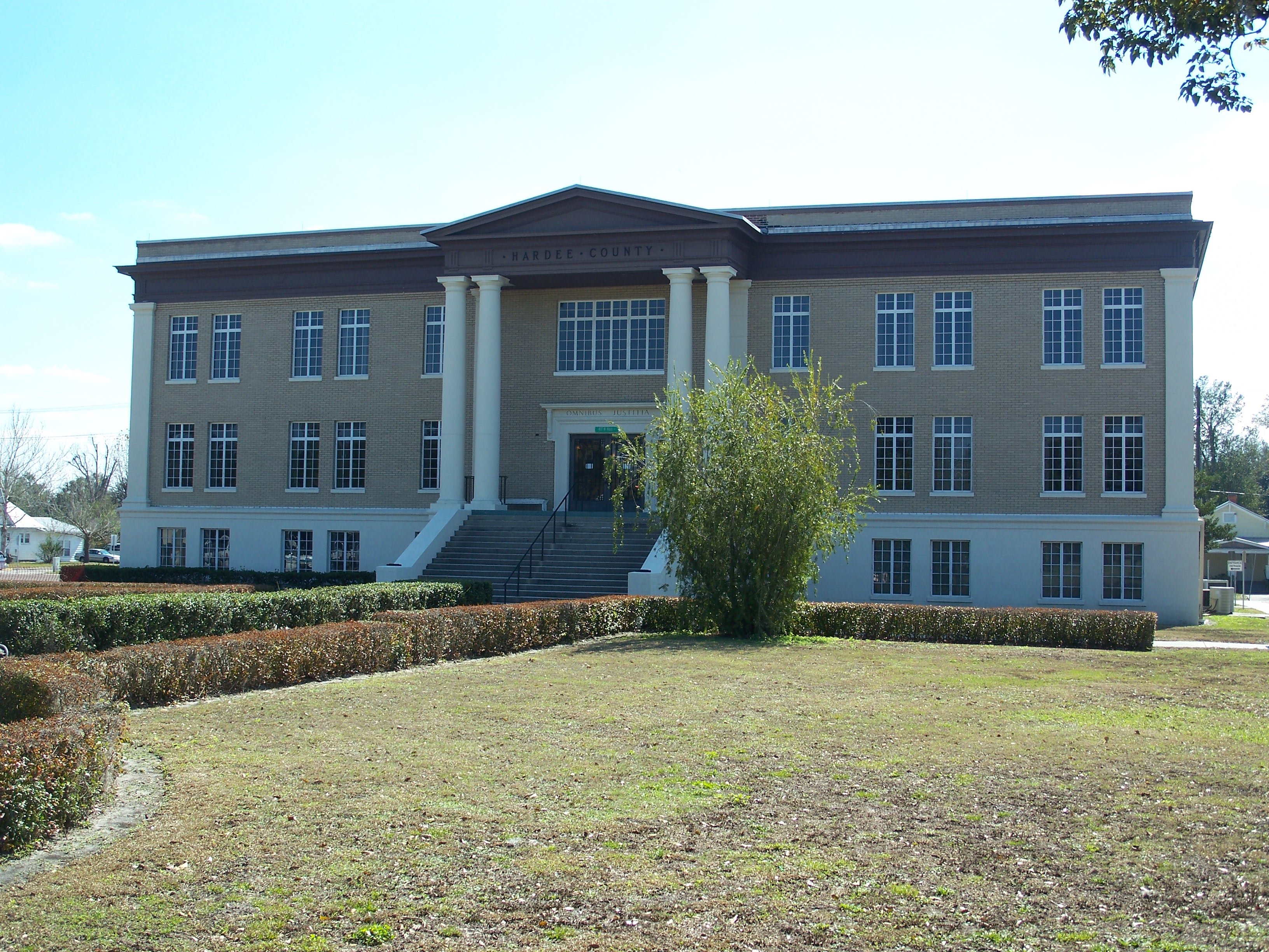
Hardee County is a county located in the Florida Heartland, Central Florida region U.S. state of Florida. As of the 2020 census, the population was 25,327. Its county seat is Wauchula. Hardee County comprises the Wauchula, FL Micropolitan Statistical Area. History It was named for Cary A. Hardee, Governor of Florida from 1921 to 1925. Hardee County was created in 1921. On August 13, 2004, Hurricane Charley went directly through Hardee County. Maximum sustained winds in downtown Wauchula were clocked at with higher gusts. Most buildings in the county sustained damage, and many were totally destroyed. Geography According to the U.S. Census Bureau, the county has a total area of , of which is land and (0.1%) is water. Hardee County is located in what is known as the "Bone Valley" which contains most of North America's phosphate deposits and a large portion of the world's deposits. Phosphate is mined in large open pit mines with massive settling ponds that contain many h ... [...More Info...] [...Related Items...] OR: [Wikipedia] [Google] [Baidu] |
Glades County, Florida
Glades County is a county located in the Florida Heartland region of the U.S. state of Florida. As of the 2020 census, the population was 12,126, making it the fourth-least populous county in Florida. Its county seat is Moore Haven. Awards * Gov. Jeb Bush acknowledged Muse winning the Florida's Outstanding Rural Community of the Year 2002 award after "providing a safe community shelter to be used during storms." * Senior Ranger Danny Callahan, of the Florida Forest Service presented Jimmy Cianfrani and the Muse Community with a "10 Year Firewise Service Award" for "its diligence and commitment to the National Firewise Communities USA program. From the smallest project of cleaning the debris off their roofs to the largest undertaking of clearing flammable vegetation 30 feet away from their houses, the Muse Community’s dedication to reducing wildfire risk is commendable." History Indigenous people lived in this area for thousands of years. Due to warfare and exposure to inf ... [...More Info...] [...Related Items...] OR: [Wikipedia] [Google] [Baidu] |
DeSoto County, Florida
DeSoto County is a county located at the tropical/humid subtropical line which means the Florida Heartland, central portion of the U.S. state of Florida. As of the 2020 census, the population was 33,976. Its county seat is Arcadia. DeSoto County comprises the Arcadia, FL Micropolitan Statistical Area, which is included in the North Port-Sarasota, FL Combined Statistical Area. History Prior to the arrival of the Spanish, what is now DeSoto County was within the territory of the Calusa Indians. In 1513, Ponce De Leon sailed into present-day Charlotte Harbor near the mouth of the Peace River to put in for repairs and maintenance on his ships. While there the Spanish encountered Calusa Indians and soon after an argument broke out and several died on both sides. Then the Spanish kidnapped several Calusa and departed Charlotte Harbor and sailed S.W. away from the west coast of Florida. This occurred within the original boundaries of DeSoto County. In 1521, Ponce De Leon atte ... [...More Info...] [...Related Items...] OR: [Wikipedia] [Google] [Baidu] |
Lake Okeechobee
Lake Okeechobee (), also known as Florida's Inland Sea, is the largest freshwater lake in the U.S. state of Florida. It is the tenth largest natural freshwater lake among the 50 states of the United States and the second-largest natural freshwater lake contained entirely within the contiguous 48 states, after Lake Michigan. Okeechobee covers and is exceptionally shallow for a lake of its size, with an average depth of only . It is not only the largest lake in Florida or the largest lake in the southeast United States, but it is too large to see across, giving it the feel of an ocean. The Kissimmee River, located directly north of Lake Okeechobee, is the lake's primary source. The lake is divided between Glades, Okeechobee, Martin, Palm Beach and Hendry counties. All five counties meet at one point near the center of the lake. History The earliest recorded people to have lived around the lake were the Calusa. They called the lake Mayaimi, meaning "big water," as reported in ... [...More Info...] [...Related Items...] OR: [Wikipedia] [Google] [Baidu] |
Tampa Bay
Tampa Bay is a large natural harbor and shallow estuary connected to the Gulf of Mexico on the west-central coast of Florida, comprising Hillsborough Bay, McKay Bay, Old Tampa Bay, Middle Tampa Bay, and Lower Tampa Bay. The largest freshwater inflow into the bay is the Hillsborough River, which flows into Hillsborough Bay in downtown Tampa. Many other smaller rivers and streams also flow into Tampa Bay, resulting in a large watershed area. The shores of Tampa Bay were home to the Weedon Island Culture and then the Safety Harbor culture for thousands of years. These cultures relied heavily on Tampa Bay for food, and the waters were rich enough that they were one of the few Native American cultures that did not have to farm. The Tocobaga was likely the dominant chiefdom in the area when Spanish explorers arrived in the early 1500s, but there were likely smaller chiefdoms on the eastern side of the bay which were not well documented. The indigenous population had been decimated b ... [...More Info...] [...Related Items...] OR: [Wikipedia] [Google] [Baidu] |
2010 United States Redistricting Cycle
The 2010 United States redistricting cycle took place following the completion of the 2010 United States census. In all fifty states, various bodies re-drew state legislative districts. States that are apportioned more than one seat in the United States House of Representatives also drew new districts for that legislative body. The resulting new districts were first implemented for the 2011 and 2012 elections. The rules for redistricting vary from state to state, but all states draw new legislative and congressional maps either in the state legislature, in redistricting commissions, or through some combination of the state legislature and a redistricting commission. Though various laws and court decisions have put constraints on redistricting, many redistricting institutions continue to practice gerrymandering, which involves drawing new districts with the intention of giving a political advantage to specific groups. Political parties prepare for redistricting years in advance, ... [...More Info...] [...Related Items...] OR: [Wikipedia] [Google] [Baidu] |


