|
Fjard
A fjard ( sv, fjärd, ) is a large open space of water between groups of islands or mainland in archipelagos. Fjards can be found along sea coasts, in freshwater lakes or rivers. Fjard and fjord were originally the same word with the general meaning of sailable waterway. In Scandinavia, fjords dominate along the North Sea coast while fjards dominate the Baltic Sea coast. Fjards vs. fjords vs. förden vs. rias Although fjards and fjords are similar in that they are a glacially-formed topography, they still differ in some key ways: * Fjords are characterized by steep high relief cliffs carved by glacial activity and often have split or branching channels. * Fjards are a glacial depression or valley that has much lower relief than a fjord. Fjards fill with eroded local materials which assists "filling" along with rising sea level since the last ice age contributing as well. Other low relief landforms that are only associated with fjards such as mud flats, salt marshes, and fl ... [...More Info...] [...Related Items...] OR: [Wikipedia] [Google] [Baidu] |
Fjord
In physical geography, a fjord or fiord () is a long, narrow inlet with steep sides or cliffs, created by a glacier. Fjords exist on the coasts of Alaska, Antarctica, British Columbia, Chile, Denmark, Germany, Greenland, the Faroe Islands, Iceland, Ireland, Kamchatka, the Kerguelen Islands, Labrador, Newfoundland, New Zealand, Norway, Novaya Zemlya, Nunavut, Quebec, the Patagonia region of Argentina and Chile, Russia, South Georgia Island, Tasmania, United Kingdom, and Washington state. Norway's coastline is estimated to be long with its nearly 1,200 fjords, but only long excluding the fjords. Formation A true fjord is formed when a glacier cuts a U-shaped valley by ice segregation and abrasion of the surrounding bedrock. According to the standard model, glaciers formed in pre-glacial valleys with a gently sloping valley floor. The work of the glacier then left an overdeepened U-shaped valley that ends abruptly at a valley or trough end. Such valleys are fjords when ... [...More Info...] [...Related Items...] OR: [Wikipedia] [Google] [Baidu] |
Somes Sound
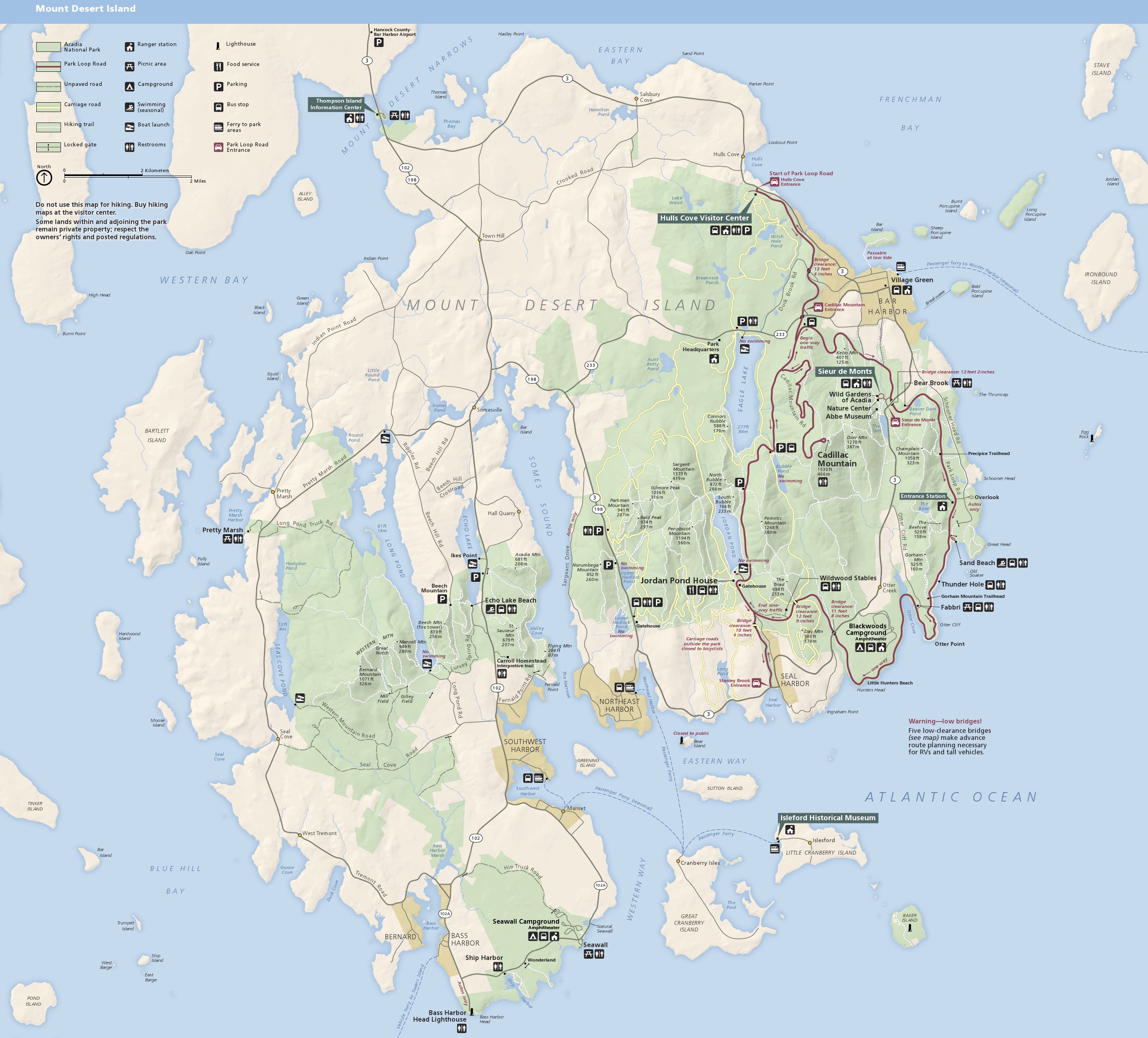
Somes Sound is a fjard, a body of water running deep into Mount Desert Island, the main site of Acadia National Park in Maine, United States. Its deepest point is approximately , and it is over deep in several places. The sound almost splits the island in two. While often described as the "only fjord on the East Coast", it lacks the extreme vertical relief and anoxic sediments associated with Norwegian fjords, and is now called a fjard by officials — a smaller drowned glacial embayment. Somes Sound was named for Abraham Somes Abraham Somes (March 14, 1732 – September 7, 1819) was an American soldier and pioneer who was the primary founder of settlements on the scenic Mount Desert Island, which is now part of Acadia National Park in present-day Maine. Personal life ..., who was one of the first settlers on the island and had a home at the end of the sound in Somesville, the first village on the island. Gallery Image:LaneFitzHughEntranceOfSomesSound.jpg, ''Entrance of ... [...More Info...] [...Related Items...] OR: [Wikipedia] [Google] [Baidu] |
Förden And East Jutland Fjorde
The eastern coast of the Jutland Peninsula, consisting of Danish Jutland and German Schleswig-Holstein features a type of narrow bay called Förde (plural: ''Förden'') in German and fjord (plural ''fjorde'') in Danish. These bays are of glacial origin, but the glacial mechanics were different from those of Norwegian Fjords and also from those of Swedish and Finnish Fjards. The words ''Förde'', ''fjord'' and ''fjard'' are of the same origin as the English word ''firth'', but today there are differences in the meaning between firth (Förde) and fjord in general. Geology When the area of the present Baltic Sea was covered by an ice sheet during the Weichselian glaciation, about 20,000 to 70,000 years ago, the edge of the ice moved on land as tongues of glaciers; these carved out channels. When the ice retreated it created a large lake. The water level rose and the channels were filled by water. The material removed formed moraine hills near the sides and ends of the channe ... [...More Info...] [...Related Items...] OR: [Wikipedia] [Google] [Baidu] |
Maine
Maine () is a U.S. state, state in the New England and Northeastern United States, Northeastern regions of the United States. It borders New Hampshire to the west, the Gulf of Maine to the southeast, and the Provinces and territories of Canada, Canadian provinces of New Brunswick and Quebec to the northeast and northwest, respectively. The largest state by total area in New England, Maine is the List of U.S. states and territories by area, 12th-smallest by area, the List of U.S. states and territories by population, 9th-least populous, the List of U.S. states by population density, 13th-least densely populated, and the most rural of the List of states and territories of the United States, 50 U.S. states. It is also the northeastern United States, northeasternmost among the contiguous United States, the northernmost state east of the Great Lakes, the only state whose name consists of a single syllable, and the only state to border exactly one other U.S. state. Approximately half ... [...More Info...] [...Related Items...] OR: [Wikipedia] [Google] [Baidu] |
Acadia National Park
Acadia National Park is an American national park located along the mid-section of the Maine coast, southwest of Bar Harbor. The park preserves about half of Mount Desert Island, part of the Isle au Haut, the tip of the Schoodic Peninsula, and portions of 16 smaller outlying islands. It protects the natural beauty of the rocky headlands, including the highest mountains along the Atlantic coast. Acadia boasts a glaciated coastal and island landscape, an abundance of habitats, a high level of biodiversity, clean air and water, and a rich cultural heritage. The park contains the tallest mountain on the Atlantic Coast of the United States ( Cadillac Mountain), exposed granite domes, glacial erratics, U-shaped valleys, and cobble beaches. Its mountains, lakes, streams, wetlands, forests, meadows, and coastlines contribute to a diversity of plants and animals. Weaved into this landscape is a historic carriage road system financed by John D. Rockefeller Jr. In total, it encompa ... [...More Info...] [...Related Items...] OR: [Wikipedia] [Google] [Baidu] |
Pwllheli
Pwllheli () is a market town and community of the Llŷn Peninsula ( cy, Penrhyn Llŷn) in Gwynedd, north-western Wales. It had a population of 4,076 in 2011 of whom a large proportion, 81%, are Welsh speaking. Pwllheli is the place where Plaid Cymru was founded. It is the birthplace of the Welsh poet Sir Albert Evans-Jones (bardic name ''Cynan''). Pwllheli has a range of shops and other services. As a local railhead with a market every Wednesday, the town is a gathering point for the population of the whole peninsula. Etymology The town's name means ''salt water basin''. History The town was given its charter as a borough by Edward, the Black Prince, in 1355, and a market is still held each Wednesday in the centre of the town on 'Y Maes' (="the field" or "the town square" in English). The town grew around the shipbuilding and fishing industries, and the granite quarry at Gimlet Rock ( cy, Carreg yr Imbill). The population in 1841 was 2,367. During the 1890s, the t ... [...More Info...] [...Related Items...] OR: [Wikipedia] [Google] [Baidu] |
Afon Alaw
The Afon Alaw ( en, River Alaw) is a river on Anglesey (Welsh Welsh may refer to: Related to Wales * Welsh, referring or related to Wales * Welsh language, a Brittonic Celtic language spoken in Wales * Welsh people People * Welsh (surname) * Sometimes used as a synonym for the ancient Britons (Celtic peopl ...: Ynys Môn) in Wales which rises near Llanerch-y-medd and flows northwards into the reservoir of Llyn Alaw. Below the dam it then flows southwestwards to the island's west coast near Llanfachraeth. Its lower reaches, west of the A5025 road, are tidal.Ordnance Survey Landranger map sheet 114 ''Anglesey/Môn'' References Rivers of Anglesey {{Wales-river-stub ... [...More Info...] [...Related Items...] OR: [Wikipedia] [Google] [Baidu] |
Water Of Fleet
The Water of Fleet is a river in Scotland flowing into Fleet Bay on the Solway Firth. Its two tributaries are the Big Water of Fleet, which begins around Loch Grannoch, and the Little Water of Fleet. The river flows through Gatehouse of Fleet before meeting the sea. The Water of Fleet rises on the slopes of Cairnsmore of Fleet, a 710 m high hill that is designated as a National Nature Reserve. Lower down, the Fleet Valley contains the best examples of upland oakwood in Kirkcudbrightshire, two of which (Killiegowan Wood and Carstramon Wood) are designated as Special Areas of Conservation. The lower part of the area surrounding the Water of Fleet is designated as the Fleet Valley National Scenic Area, one of forty such areas in Scotland, which have been defined so as to identify areas of exceptional scenery and to ensure its protection from inappropriate development. The Fleet Valley national scenic area (NSA) covers 5854 ha in total, of which 5373 ha is on ... [...More Info...] [...Related Items...] OR: [Wikipedia] [Google] [Baidu] |
Rough Firth
Rough Firth is an inlet on the northern coast of the Solway Firth in the Stewartry area of Dumfries and Galloway, Scotland. The firth lies between Almorness Point and Castlehill Point, and contains Rough Island. The village of Kippford stands near the head of the firth where the Urr Water reaches the sea; the only other coastal settlement of any size is Rockcliffe. The area is designated as the East Stewartry Coast National Scenic Area, one of the forty national scenic areas (NSAs) in Scotland. 44 ha on the eastern side of the firth is owned by the National Trust for Scotland, forming the Rockcliffe property, which covers a stretch of coastline and several small islands (including Rough Island). Description The area includes several different landscapes, as identified by Scottish Natural Heritage when undertaking a review of the "special qualities" of the area in 2010: There is a small 6th-century trading post known as the Mote of Mark, which stands on a rocky outcrop, ... [...More Info...] [...Related Items...] OR: [Wikipedia] [Google] [Baidu] |
Firth Of Clyde
The Firth of Clyde is the mouth of the River Clyde. It is located on the west coast of Scotland and constitutes the deepest coastal waters in the British Isles (it is 164 metres deep at its deepest). The firth is sheltered from the Atlantic Ocean by the Kintyre peninsula, which encloses the outer firth in Argyll and Ayrshire. The Kilbrannan Sound is a large arm of the Firth of Clyde, separating the Kintyre Peninsula from the Isle of Arran. Within the Firth of Clyde is another major island – the Isle of Bute. Given its strategic location at the entrance to the middle and upper Clyde, Bute played a vital naval military role during World War II. Geography At its entrance, the firth is about wide. At one area in its upper reaches, it is joined by Loch Long and the Gare Loch. This area includes the large anchorage off of Greenock that is known as the Tail of the Bank. (The “Bank” is a reference to the sandbank and shoal that separates the firth from the estuary o ... [...More Info...] [...Related Items...] OR: [Wikipedia] [Google] [Baidu] |
.jpg)


_NLW3363760.jpg)


