Firura
   HOME
*


Firura
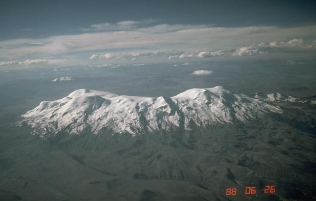
Firura is an extinct volcano of the Central Andean Volcanic Belt, located in the Arequipa Region of southern Peru. Together with Sara Sara, Solimana (volcano), Solimana and Coropuna it forms one of the Central Andean volcanoes. It is in the Andes, north of the Pucuncho Basin. Description Two domes form the Firura volcano, which has a low relief of . Lava flows and stratovolcanoes form a long field. Aside from the main summit Firura, there also are Soncco Orcco (), Jahsaya () and separating Firura from Solimana Antapuna (). The complex has generated basaltic or basaltic andesite lava flows that reach down into inhabited areas, as well as an ignimbrite resulting from the collapse of the ancient crater. A collapse of the crater was also responsible for the formation of a landslide dam in the Cotahuasi River valley. The date of the last volcanic activity is Pleistocene to Holocene, but it does not appear to be a significant hazard. Much of the southern side of the volcano above alt ...
[...More Info...]      
[...Related Items...]     OR:     [Wikipedia]   [Google]   [Baidu]  


picture info

Arequipa Region
Arequipa ( ay, Ariqipa; qu, Ariqipa) is a department and region in southwestern Peru. It is the sixth largest department in Peru, after Puno, Cuzco, Madre de Dios, Ucayali, and Loreto, its sixth most populous department, and its eleventh least densely populated department. It is bordered by the departments of Ica, Ayacucho, Apurímac and Cusco in the north, the Department of Puno in the east, the Department of Moquegua in the south, and the Pacific Ocean in the west. Its capital, also called Arequipa, is Peru's second-largest city. Geography This department has a rough topography, which is characterised by heavy layers of volcanic lava covering large areas of its inter-Andean sector. It has deep canyons such as the ones formed by the Ocoña and Majes rivers. Plateaus range in height from medium, such as La Joya, and high-altitude ones such the Arrieros Pampa and those located in the zones of Chivay, Huambo and Pichucolla. Volcanic cones, such as Misti, Chachani, Ampato, ...
[...More Info...]      
[...Related Items...]     OR:     [Wikipedia]   [Google]   [Baidu]  


picture info

Coropuna
Coropuna is a dormant compound volcano located in the Andes mountains of southeast-central Peru. The upper reaches of Coropuna consist of several perennially snowbound conical summits, lending it the name Nevado Coropuna in Spanish. The complex extends over an area of and its highest summit reaches an altitude of above sea level. This makes the Coropuna complex the third-highest of Peru. Its thick ice cap is the most extensive in Earth's tropical zone, with several outlet glaciers stretching out to lower altitudes. Below an elevation of , there are various vegetation belts which include trees, peat bogs, grasses and also agricultural areas and pastures. The Coropuna complex consists of several stratovolcanos. These are composed chiefly of ignimbrites and lava flows on a basement formed by Middle Miocene ignimbrites and lava flows. The Coropuna complex has been active for at least five million years, with the bulk of the current cone having been formed during the Quat ...
[...More Info...]      
[...Related Items...]     OR:     [Wikipedia]   [Google]   [Baidu]  


picture info

Pleistocene
The Pleistocene ( , often referred to as the ''Ice age'') is the geological Epoch (geology), epoch that lasted from about 2,580,000 to 11,700 years ago, spanning the Earth's most recent period of repeated glaciations. Before a change was finally confirmed in 2009 by the International Union of Geological Sciences, the cutoff of the Pleistocene and the preceding Pliocene was regarded as being 1.806 million years Before Present (BP). Publications from earlier years may use either definition of the period. The end of the Pleistocene corresponds with the end of the last glacial period and also with the end of the Paleolithic age used in archaeology. The name is a combination of Ancient Greek grc, label=none, πλεῖστος, pleÄ«stos, most and grc, label=none, καινός, kainós (latinized as ), 'new'. At the end of the preceding Pliocene, the previously isolated North and South American continents were joined by the Isthmus of Panama, causing Great American Interchang ...
[...More Info...]      
[...Related Items...]     OR:     [Wikipedia]   [Google]   [Baidu]  


picture info

Mountains Of Peru
A mountain is an elevated portion of the Earth's crust, generally with steep sides that show significant exposed bedrock. Although definitions vary, a mountain may differ from a plateau in having a limited summit area, and is usually higher than a hill, typically rising at least 300 metres (1,000 feet) above the surrounding land. A few mountains are isolated summits, but most occur in mountain ranges. Mountains are formed through tectonic forces, erosion, or volcanism, which act on time scales of up to tens of millions of years. Once mountain building ceases, mountains are slowly leveled through the action of weathering, through slumping and other forms of mass wasting, as well as through erosion by rivers and glaciers. High elevations on mountains produce colder climates than at sea level at similar latitude. These colder climates strongly affect the ecosystems of mountains: different elevations have different plants and animals. Because of the less hospitable terrain ...
[...More Info...]      
[...Related Items...]     OR:     [Wikipedia]   [Google]   [Baidu]  


picture info

Mountains Of Arequipa Region
A mountain is an elevated portion of the Earth's crust, generally with steep sides that show significant exposed bedrock. Although definitions vary, a mountain may differ from a plateau in having a limited summit area, and is usually higher than a hill, typically rising at least 300 metres (1,000 feet) above the surrounding land. A few mountains are isolated summits, but most occur in mountain ranges. Mountains are formed through tectonic forces, erosion, or volcanism, which act on time scales of up to tens of millions of years. Once mountain building ceases, mountains are slowly leveled through the action of weathering, through slumping and other forms of mass wasting, as well as through erosion by rivers and glaciers. High elevations on mountains produce colder climates than at sea level at similar latitude. These colder climates strongly affect the ecosystems of mountains: different elevations have different plants and animals. Because of the less hospitable terrain and ...
[...More Info...]      
[...Related Items...]     OR:     [Wikipedia]   [Google]   [Baidu]  


picture info

Volcanoes Of Peru
A volcano is a rupture in the crust of a planetary-mass object, such as Earth, that allows hot lava, volcanic ash, and gases to escape from a magma chamber below the surface. On Earth, volcanoes are most often found where tectonic plates are diverging or converging, and most are found underwater. For example, a mid-ocean ridge, such as the Mid-Atlantic Ridge, has volcanoes caused by divergent tectonic plates whereas the Pacific Ring of Fire has volcanoes caused by convergent tectonic plates. Volcanoes can also form where there is stretching and thinning of the crust's plates, such as in the East African Rift and the Wells Gray-Clearwater volcanic field and Rio Grande rift in North America. Volcanism away from plate boundaries has been postulated to arise from upwelling diapirs from the core–mantle boundary, deep in the Earth. This results in hotspot volcanism, of which the Hawaiian hotspot is an example. Volcanoes are usually not created where two tectonic plates slide pa ...
[...More Info...]      
[...Related Items...]     OR:     [Wikipedia]   [Google]   [Baidu]  


SERNAGEOMIN
250px, Sernageomin building in Providencia, Santiago. The National Geology and Mining Service ( es, Servicio Nacional de Geología y Minería; SERNAGEOMIN) is a Chilean government agency. Its function is to provide geological information and advice, technical assistance to government, public and private interests, and to regulate the mining industry in Chile. The service was formed in 1980 by the combination of the previous Institute of Geological Investigations and the State Mines Service. Its director is appointed by the President of Chile The president of Chile ( es, Presidente de Chile), officially known as the President of the Republic of Chile ( es, Presidente de la República de Chile), is the head of state and head of government of the Republic of Chile. The president is re ....United States Geological Survey">United States Geological Survey web site, The volcanos in Chile are monitored by SERNAGEOMIN Since 1974, SERNAGEOMIN has published the scientific journal ''An ...
[...More Info...]      
[...Related Items...]     OR:     [Wikipedia]   [Google]   [Baidu]  


picture info

Last Glacial Maximum
The Last Glacial Maximum (LGM), also referred to as the Late Glacial Maximum, was the most recent time during the Last Glacial Period that ice sheets were at their greatest extent. Ice sheets covered much of Northern North America, Northern Europe, and Asia and profoundly affected Earth's climate by causing drought, desertification, and a large drop in sea levels. Based on changes in position of ice sheet margins dated via terrestrial cosmogenic nuclides and radiocarbon dating, growth of ice sheets commenced 33,000 years ago and maximum coverage was between 26,500 years and 19–20,000 years ago, when deglaciation commenced in the Northern Hemisphere, causing an abrupt rise in sea level. Decline of the West Antarctica ice sheet occurred between 14,000 and 15,000 years ago, consistent with evidence for another abrupt rise in the sea level about 14,500 years ago. Glacier fluctuations around the Strait of Magellan suggest the peak in glacial surface area was constrained to betwee ...
[...More Info...]      
[...Related Items...]     OR:     [Wikipedia]   [Google]   [Baidu]  


picture info

Moraine
A moraine is any accumulation of unconsolidated debris (regolith and rock), sometimes referred to as glacial till, that occurs in both currently and formerly glaciated regions, and that has been previously carried along by a glacier or ice sheet. It may consist of partly rounded particles ranging in size from boulders (in which case it is often referred to as boulder clay) down to gravel and sand, in a groundmass of finely-divided clayey material sometimes called glacial flour. Lateral moraines are those formed at the side of the ice flow, and terminal moraines were formed at the foot, marking the maximum advance of the glacier. Other types of moraine include ground moraines (till-covered areas forming sheets on flat or irregular topography) and medial moraines (moraines formed where two glaciers meet). Etymology The word ''moraine'' is borrowed from French , which in turn is derived from the Savoyard Italian ("mound of earth"). ''Morena'' in this case was derived from Provenà ...
[...More Info...]      
[...Related Items...]     OR:     [Wikipedia]   [Google]   [Baidu]  


picture info

Equilibrium Line Altitude
Glaciology (; ) is the scientific study of glaciers, or more generally ice and natural phenomena that involve ice. Glaciology is an interdisciplinary Earth science that integrates geophysics, geology, physical geography, geomorphology, climatology, meteorology, hydrology, biology, and ecology. The impact of glaciers on people includes the fields of human geography and anthropology. The discoveries of water ice on the Moon, Mars, Europa and Pluto add an extraterrestrial component to the field, which is referred to as "astroglaciology". Overview A glacier is an extended mass of ice formed from snow falling and accumulating over a long period of time; glaciers move very slowly, either descending from high mountains, as in valley glaciers, or moving outward from centers of accumulation, as in continental glaciers. Areas of study within glaciology include glacial history and the reconstruction of past glaciation. A glaciologist is a person who studies glaciers. A glacial geolog ...
[...More Info...]      
[...Related Items...]     OR:     [Wikipedia]   [Google]   [Baidu]  


picture info

Glacier
A glacier (; ) is a persistent body of dense ice that is constantly moving under its own weight. A glacier forms where the accumulation of snow exceeds its Ablation#Glaciology, ablation over many years, often Century, centuries. It acquires distinguishing features, such as Crevasse, crevasses and Serac, seracs, as it slowly flows and deforms under stresses induced by its weight. As it moves, it abrades rock and debris from its substrate to create landforms such as cirques, moraines, or fjords. Although a glacier may flow into a body of water, it forms only on land and is distinct from the much thinner sea ice and lake ice that form on the surface of bodies of water. On Earth, 99% of glacial ice is contained within vast ice sheets (also known as "continental glaciers") in the polar regions, but glaciers may be found in mountain ranges on every continent other than the Australian mainland, including Oceania's high-latitude oceanic island countries such as New Zealand. Between lati ...
[...More Info...]      
[...Related Items...]     OR:     [Wikipedia]   [Google]   [Baidu]  


picture info

Holocene
The Holocene ( ) is the current geological epoch. It began approximately 11,650 cal years Before Present (), after the Last Glacial Period, which concluded with the Holocene glacial retreat. The Holocene and the preceding Pleistocene together form the Quaternary period. The Holocene has been identified with the current warm period, known as MIS 1. It is considered by some to be an interglacial period within the Pleistocene Epoch, called the Flandrian interglacial.Oxford University Press – Why Geography Matters: More Than Ever (book) – "Holocene Humanity" section https://books.google.com/books?id=7P0_sWIcBNsC The Holocene corresponds with the rapid proliferation, growth and impacts of the human species worldwide, including all of its written history, technological revolutions, development of major civilizations, and overall significant transition towards urban living in the present. The human impact on modern-era Earth and its ecosystems may be considered of global si ...
[...More Info...]      
[...Related Items...]     OR:     [Wikipedia]   [Google]   [Baidu]