|
Fils (river)
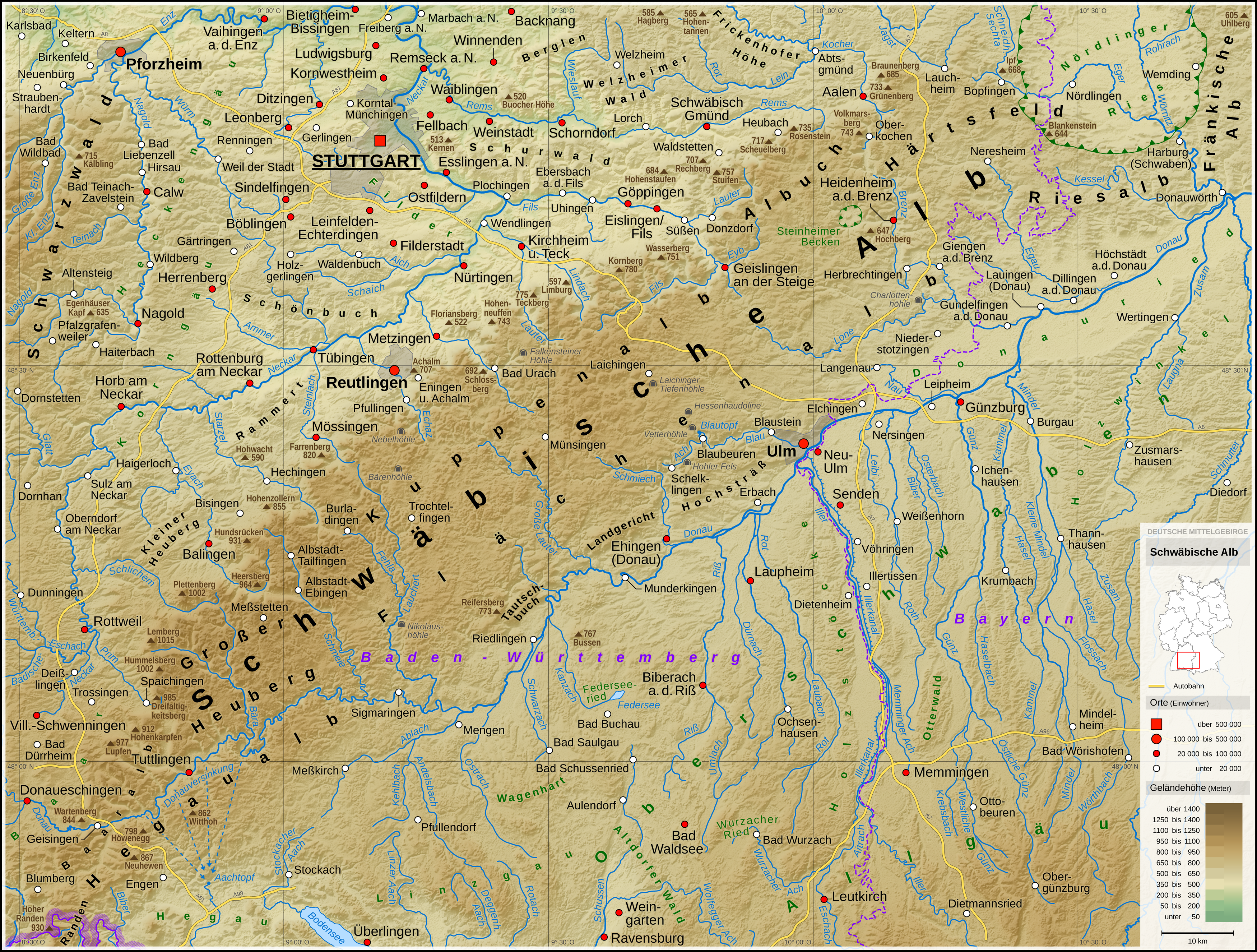
The Fils is a river in Baden-Württemberg, Germany, a right tributary of the Neckar. Its source is in the Swabian Alb hills near Wiesensteig. It flows through Geislingen (Steige) and Göppingen to join the Neckar east of Stuttgart, in Plochingen. Due to the contribution of the Fils, the Neckar is navigable from there. Geography Course The Fils has its source on the Swabian Alb about two kilometers southwest of the town Wiesensteig. Its karst spring, the Filsursprung, lies at 624.9 m in the Hasental valley, which has remained close to nature. There are two more springs a little further down, the Kleiner Filsursprung on the right and the Hasenquelle on the left at the foot of the slope. The young river - initially running in a north-easterly direction - crosses the community Mühlhausen im Täle after Wiesensteig, where the Hollbach flows on the left side and the Bundesautobahn 8 crosses the valley. Then follows Gosbach with the mouth of the Gos (Fils), Gos on the right sid ... [...More Info...] [...Related Items...] OR: [Wikipedia] [Google] [Baidu] |
Swabian Alb
The Swabian Jura (german: Schwäbische Alb , more rarely ), sometimes also named Swabian Alps in English, is a mountain range in Baden-Württemberg, Germany, extending from southwest to northeast and in width. It is named after the region of Swabia. The Swabian Jura occupies the region bounded by the Danube in the southeast and the upper Neckar in the northwest. In the southwest it rises to the higher mountains of the Black Forest. The highest mountain of the region is the Lemberg (). The area's profile resembles a high plateau, which slowly falls away to the southeast. The northwestern edge is a steep escarpment (called the Albtrauf or Albanstieg, rising up , covered with forests), while the top is flat or gently rolling. In economic and cultural terms, the Swabian Jura includes regions just around the mountain range. It is a popular recreation area. Geology The geology of the Swabian Jura is mostly limestone, which formed the seabed during the Jurassic period. The sea r ... [...More Info...] [...Related Items...] OR: [Wikipedia] [Google] [Baidu] |
Gos (Fils)
Gos is a -long river of Baden-Württemberg, Germany. It is a tributary of the Fils (river), Fils near Bad Ditzenbach. See also *List of rivers of Baden-Württemberg Rivers of Baden-Württemberg Rivers of Germany {{BadenWürttemberg-river-stub ... [...More Info...] [...Related Items...] OR: [Wikipedia] [Google] [Baidu] |
Süßen
Süßen (or Süssen) is a town in the district of Göppingen in Baden-Württemberg in southern Germany. It is located on the river Fils 8 km east of Göppingen, near Stuttgart. History Süßen was first mentioned with the name of ''Siezun'' in the Lorsch codex in 1071. Großsüßen (Greater'' Süßen'') was at first in the possession of the count of Helfenstein, who, in 1382 pledged it to the city of Ulm. Kleinsüßen (Smaller ''Süßen''),though, was in the hands of the family Pappenheim. They inherited the land from the landlords of Bubenhofen. In the Mediatization in 1802, Großsüßen was given to Bavaria, but in 1810, the lands were given back, in an exchange contract to Württemberg. Kleinsüßen, though, was never Bavarian land. After the exchange, both places, Groß- and Kleinsüßen, were assigned under the Head Office of Geislingen. With the opening of the Fils Valley Railway and Süßen station in 1847, Kleinsüßen was connected to the public transportation. In ... [...More Info...] [...Related Items...] OR: [Wikipedia] [Google] [Baidu] |
Gingen An Der Fils
Gingen an der Fils is a municipality in the district of Göppingen in Baden-Württemberg, Germany. Geography The municipality (''Gemeinde'') of Gingen an der Fils is found in the district of Göppingen, in Baden-Württemberg, one of the 16 States of the Federal Republic of Germany. Gingen is physically located in the valley of the Fils, up to the hills of the , in the of the Swabian Jura. Elevation above sea level in the municipal area ranges from a high of Normalnull (NN) to a low of NN. Gingen an der Fils includes the hamlet of Grünenberg as well as the ghost town Marrbach. Geological demographics Source: History Some time between 1382 and 1396, Gingen was sold by the County of Helfenstein to the Free Imperial City of Ulm, whose bailiff resided in the town until 1750. Gingen became a possession of the Electorate of Bavaria in 1802, but was ceded in 1810 to the Kingdom of Württemberg. Gingen was assigned to . In 1845, the town was connected to the growing network ... [...More Info...] [...Related Items...] OR: [Wikipedia] [Google] [Baidu] |
Kuchen, Baden-Württemberg
Kuchen is a municipality of the district of Göppingen in Baden-Württemberg, Germany. History The earliest historical document ion of Kuchen, from between 1304 and 1315, refers to it as a "town" (''stadt''), implying that it received town rights from the Count of Helfenstein in the first half of the 13th century. Kuchen was made a market town in 1356. At some point between the years 1382 and 1396, Kuchen became a possession of the Free Imperial City of Ulm. Ulm and by extension Kuchen was annexed by the Electorate of Bavaria in 1802, but was ceded in 1810 to the Kingdom of Württemberg and then assigned to . The Fils Valley Railway was constructed through Kuchen in 1845. Kuchen was reassigned in 1938 to the newly-reorganized district of Göppingen. The town grew in every direction after World War II, and then again in the 1970s to the northeast. Geography The municipality (''Gemeinde'') of Kuchen is situated in the district of Göppingen, in Baden-Württemberg, one of the 16 ... [...More Info...] [...Related Items...] OR: [Wikipedia] [Google] [Baidu] |
Swabian Keuper-Lias Plains
The Swabian Keuper-Lias Plains (german: Schwäbisches Keuper-Lias-Land) is a major natural region in southwest Germany and includes the southwesternmost part of the Keuper Uplands, which is bordered immediately to the north by the Swabian Jura. Natural regions The Swabian Keuper lands are divided into three natural regional groups and their 3-figure major units which are given 3-figure numbers: Map of the major natural regional groups with a list of the main units (German) * 10 (=D58) Swabian Keuper-Lias Plains ** 100 Foreland of the western Swabian Jura (''Vorland der mittleren Schwäbischen Alb'') ** 101 Foreland of the central Swabian Jura (''Vorland der mittleren Schwäbischen Alb'') ** 102 Foreland of the eastern Swabian Jura (''Vorland der östlichen ... [...More Info...] [...Related Items...] OR: [Wikipedia] [Google] [Baidu] |
Valley Spider
A valley is an elongated low area often running between Hill, hills or Mountain, mountains, which will typically contain a river or stream running from one end to the other. Most valleys are formed by erosion of the land surface by rivers or streams over a very long period. Some valleys are formed through erosion by glacier, glacial ice. These glaciers may remain present in valleys in high mountains or polar areas. At lower latitudes and altitudes, these glaciation, glacially formed valleys may have been created or enlarged during ice ages but now are ice-free and occupied by streams or rivers. In desert areas, valleys may be entirely dry or carry a watercourse only rarely. In karst, areas of limestone bedrock, dry valleys may also result from drainage now taking place cave, underground rather than at the surface. Rift valleys arise principally from tectonics, earth movements, rather than erosion. Many different types of valleys are described by geographers, using terms th ... [...More Info...] [...Related Items...] OR: [Wikipedia] [Google] [Baidu] |
Eyb (river)
Eyb is a river of Baden-Württemberg, Germany. It flows into the Fils in Geislingen an der Steige. See also *List of rivers of Baden-Württemberg A list of rivers of Baden-Württemberg, Germany: A * Aal * Aalbach *Aalenbach * Ablach * Ach *Acher *Adelbach *Aich *Aid * Aischbach, tributary of the Kinzig * Aischbach, tributary of the Körsch * Aitrach, tributary of the Danube * Aitrach, tri ... References Rivers of Baden-Württemberg Rivers of Germany {{BadenWürttemberg-river-stub ... [...More Info...] [...Related Items...] OR: [Wikipedia] [Google] [Baidu] |
Geislingen An Der Steige
Geislingen an der Steige is surrounded by the heights of the Swabian Alb and embedded in 5 beautiful valleys. It is a town in the district of Göppingen in Baden-Württemberg in southern Germany. The name relates to its location "on the climb" (''an der steige'') of a trade route over the Swabian Jura mountain range. It is in the southeast of the Stuttgart region about 50 km of Stuttgart and 27 km of Ulm. It is the second largest city in the district of Göppingen. The city is characterized by a grown industry and attractive surroundings of the Swabian Albtrauf adventure region - this creates a positive environment for regionally and internationally oriented companies. Geislingen's economic significance lies above all in the steel and metal goods processing and automotive supply sectors. Geislingen is also a city of students. The University of Applied Sciences for Economy and Environment is known far beyond the borders with best rankings.A medieval town with alemanni ... [...More Info...] [...Related Items...] OR: [Wikipedia] [Google] [Baidu] |
Bad Überkingen
Bad Überkingen is a municipality in the district of Göppingen in Baden-Württemberg, Germany. History The three towns of Bad Überkingen, Hausen an der Fils, and Unterböhringen were ceded by the Free Imperial City of Ulm to the Electorate of Bavaria in 1802. In 1810, Bavaria ceded the three towns to the Kingdom of Württemberg, whose government assigned them to . Bad Überkingen was allowed to append the prefix "Bad" to its name in 1927. The district of Göppingen was reorganized in 1938 as Landkreis Göppingen, its current and contemporary form. Hausen an der Fils and Unterböhringen were incorporated into Bad Überkingen in 1973. Geography The municipality (''Gemeinde'') of Bad Überkingen is situated in the district of Göppingen, in Baden-Württemberg, one of the 16 States of the Federal Republic of Germany. Bad Überkingen is physically located in the of the Swabian Jura, in the upper Fils river valley as far as the . Elevation above sea level in the municipal area ran ... [...More Info...] [...Related Items...] OR: [Wikipedia] [Google] [Baidu] |
Hausen An Der Fils
Hausen may refer to: Places in Germany Bavaria *Hausen, Miltenberg, in the Miltenberg district *Hausen, Lower Bavaria, in the Kelheim district *Hausen, Upper Franconia, in the Forchheim district *Hausen, Rhön-Grabfeld, in the Rhön-Grabfeld district * Hausen, Villenbach * Hausen, Greding, a locality in Greding, district of Roth * Hausen bei Würzburg, in the Würzburg district *Hausen bei Aindling, a locality of Aichach-Friedberg *Hausen bei Augsburg, a locality in Diedorf, district of Augsburg *Hausen bei Bad Kissingen, a locality in Bad Kissingen Baden-Württemberg *, in Sigmaringen district, in the former Principality of Fürstenberg *Hausen am Tann, in Zollernalbkreis district *Hausen vor Wald, in Schwarzwald-Baar-Kreis district *Hausen im Wiesental, in Lörrach district *, in Heilbronn district on the Württemberger Weinstraße *Hausen an der Möhlin, ''Ortsteil'' of Bad Krozingen, Breisgau-Hochschwarzwald Hesse *Hausen (Frankfurt am Main); a city district of Frankfurt am ... [...More Info...] [...Related Items...] OR: [Wikipedia] [Google] [Baidu] |
Reichenbach Im Täle
Reichenbach may refer to: Places Austria * Reichenbach (Litschau), a part of Litschau * Reichenbach (Rappottenstein), a part of Rappottenstein Germany * Reichenbach (Oberlausitz), in Niederschlesischer Oberlausitzkreis district, Saxony * Reichenbach im Vogtland, in Vogtlandkreis district, Saxony * Reichenbach am Heuberg, in Tuttlingen district, Baden-Württemberg * Reichenbach an der Fils, in Esslingen district, Baden-Württemberg * Reichenbach, Upper Palatinate, in Cham district, Bavaria ** Reichenbach Abbey (Bavaria), Benedictine monastery in Reichenbach * Reichenbach, Upper Franconia, in Kronach district, Bavaria * Reichenbach, Thuringia in Saale-Holzland district, Thuringia * Reichenbach, Birkenfeld, in Birkenfeld district, Rhineland-Palatinate * Reichenbach (Hornberg), in the Black Forest, Baden-Württemberg * Reichenbach-Steegen in Kaiserslautern district, Rhineland-Palatinate * Reichenbach, a part of Hessisch Lichtenau, Hesse * Reichenbach, a part of Lautertal (Ode ... [...More Info...] [...Related Items...] OR: [Wikipedia] [Google] [Baidu] |


