|
Fort Miles
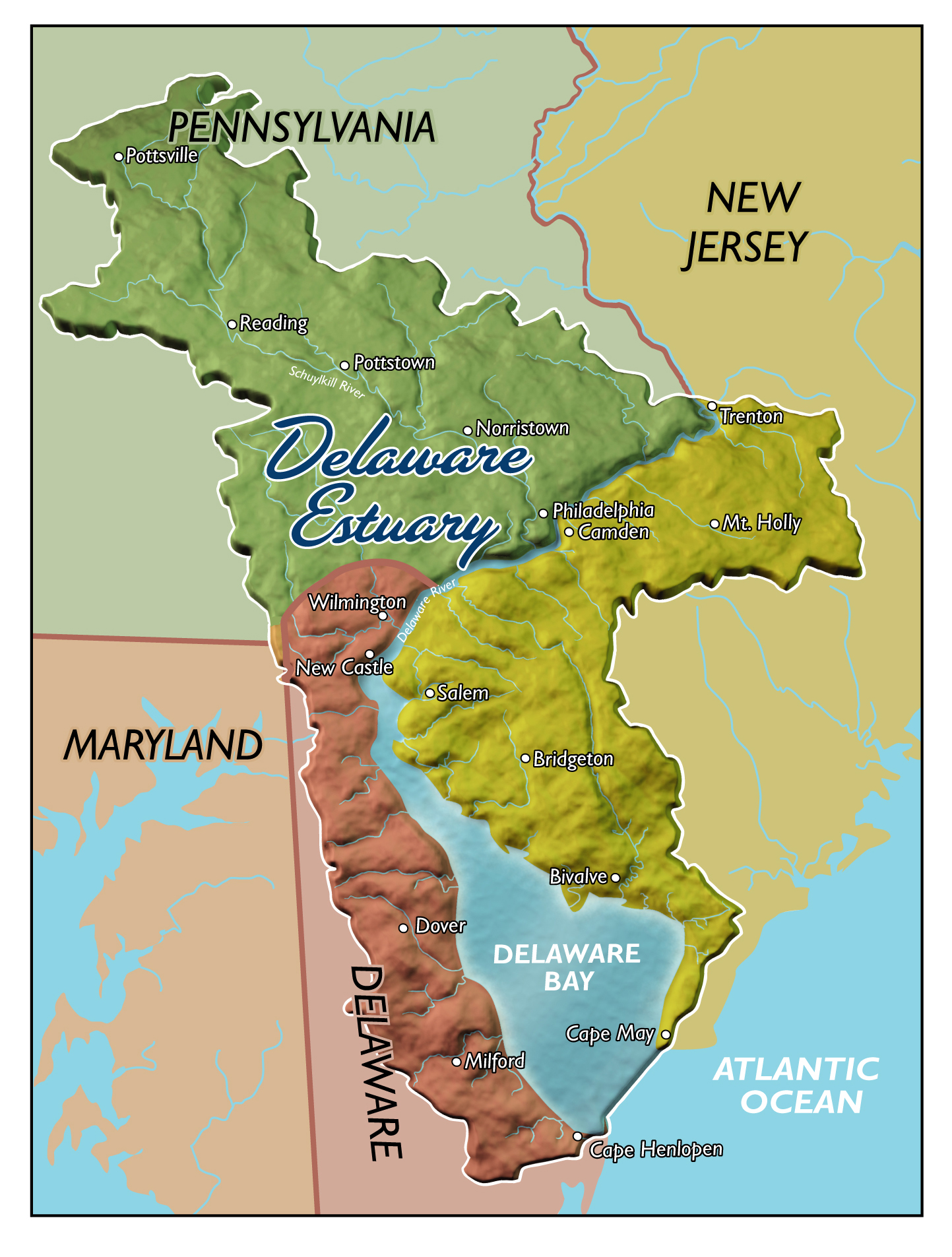
Fort Miles was a United States Army World War II installation located on Cape Henlopen near Lewes, Delaware. Although funds to build the fort were approved in 1934, it was 1938 before construction began on the fort. On 3 June 1941 it was named for Lieutenant General Nelson A. Miles. As the primary fort of the Harbor Defenses of the Delaware, it was built to defend Delaware Bay and the Delaware River and to protect domestic shipping from enemy fire between Cape May and Cape Henlopen, particularly from the German surface fleet. The fort also operated a controlled underwater minefield to prevent ships entering the Delaware River estuary. One of these mines was revealed following 2016 Hurricane Hermine by local Cape Henlopen state park staff. The sea mine and anchor were archaeologically conserved. By 1950 the Army's coast defense role had been transferred to the Navy and coastal artillery defenses were obsolete with the fort becoming surplus. The Army continued to use porti ... [...More Info...] [...Related Items...] OR: [Wikipedia] [Google] [Baidu] |
Harbor Defenses Of The Delaware
The Harbor Defenses of the Delaware was a United States Army Coast Artillery Corps Harbor Defense Command, harbor defense command. It coordinated the coastal defence and fortification, coast defenses of the Delaware River estuary from 1897 to 1950, beginning with the Board of Fortifications, Endicott program. These included both coastal artillery, coast artillery forts and Submarine mines in United States harbor defense, underwater minefields. The areas protected included the cities of Philadelphia, Camden, New Jersey, Camden, and Wilmington, Delaware, Wilmington along with the Chesapeake & Delaware Canal. The command originated circa 1896 as an Artillery District and became the Coast Defenses of the Delaware in 1913, with defenses initially at and near Fort Delaware on Pea Patch Island near Delaware City, Delaware, Delaware City. In 1925 the command was renamed as a Harbor Defense Command. During World War II the defenses were relocated to Fort Miles on Cape Henlopen at the mouth ... [...More Info...] [...Related Items...] OR: [Wikipedia] [Google] [Baidu] |
Cape Henlopen
Cape Henlopen is the southern cape of the Delaware Bay along the Atlantic coast of the United States. It lies in the state of Delaware, near the town of Lewes, where the Delaware Bay meets the Atlantic Ocean. Off the coast on the bay side are two lighthouses, called the Harbor of Refuge Light and the Delaware Breakwater East End Light. Early history Cape Henlopen, originally spelled Cape Hinlopen (after its namesake Thijmen Jacobsz Hinlopen who was a prominent Dutch trader), was New Netherland's southernmost border on the 37th parallel north. In 1620, Thijmen Jacobsz Hinlopen became the business partner of Cornelis Jacobsen Mey in the now washed out Cape Cornelius and the incorrectly spelled Cape May with the ships Blijde Boodschap (English: "Good News") and Bever both of which focused on exploration and trade with the Indians on the Delaware River (then Zuidt Rivier). The area between the 38th and 40th parallels (i.e., the Delaware Bay area) as well as the Delaware River ... [...More Info...] [...Related Items...] OR: [Wikipedia] [Google] [Baidu] |
Fort Delaware
Fort Delaware is a former harbor defense facility, designed by chief engineer Joseph Gilbert Totten and located on Pea Patch Island in the Delaware River.Dobbs, Kelli W., et al. During the American Civil War (1861-1865), the Union / United States Department of War / United States Army used Fort Delaware as a prison for Confederate prisoners of war, political prisoners, miscellaneous civilians, federal convicts, and privateer officers. A three-gun concrete battery of 12-inch guns, later named Battery Torbert, was designed by Maj. Charles W. Raymond and built inside the fort in the 1890s. By 1900, the fort was part of a three fort concept, the first forts of the Coast Defenses of the Delaware, working closely with Fort Mott further upstream on the opposite shore, in Pennsville, New Jersey, and Fort DuPont downstream in Delaware City, Delaware. The fort and the island currently belong to the Delaware Department of Natural Resources and Environmental Control (DNRE ... [...More Info...] [...Related Items...] OR: [Wikipedia] [Google] [Baidu] |
12-inch Gun M1895
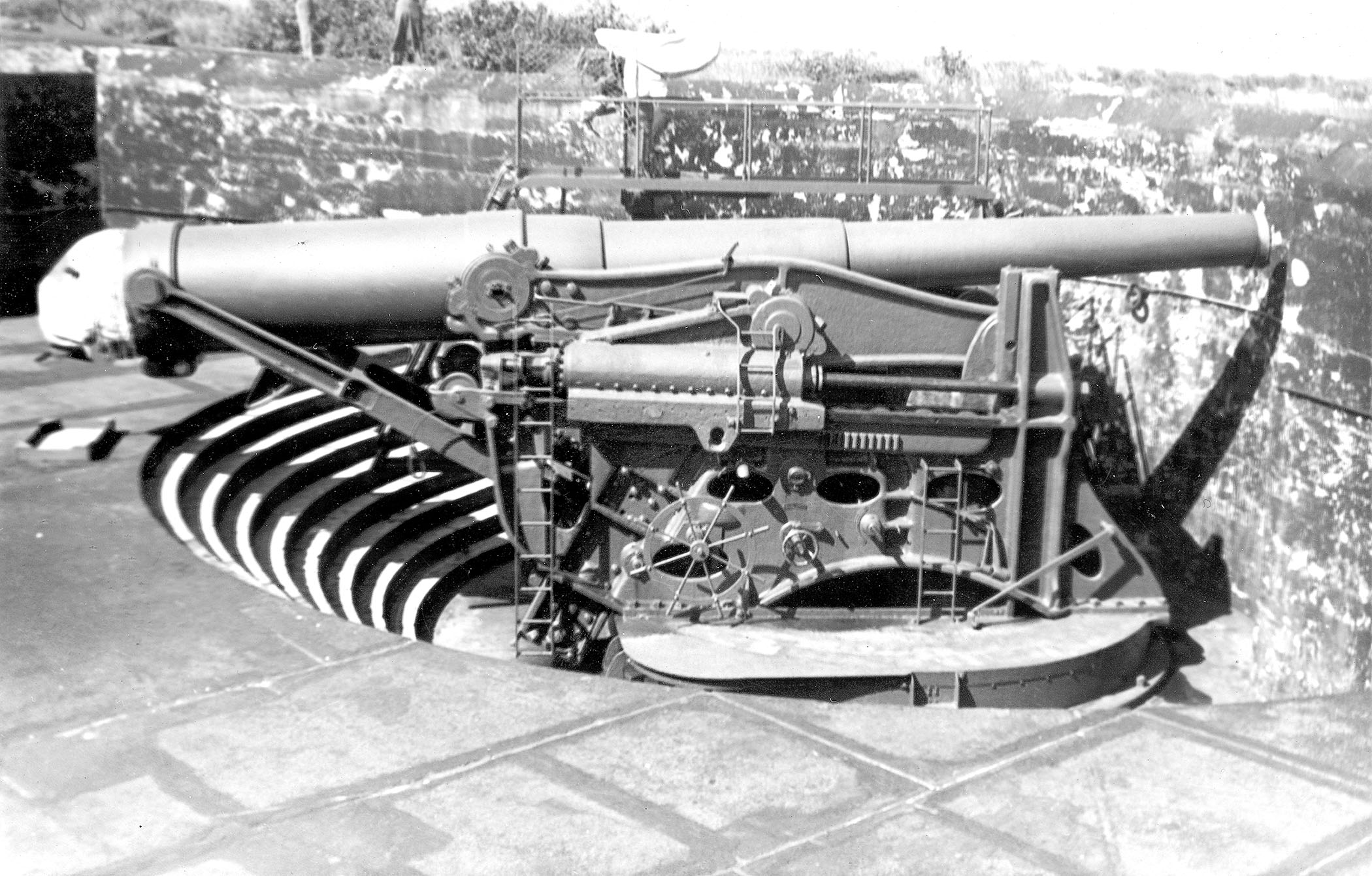
The 12-inch coastal defense gun M1895 (305 mm) and its variants the M1888 and M1900 were large coastal artillery pieces installed to defend major American seaports between 1895 and 1945. For most of their history they were operated by the United States Army Coast Artillery Corps. Most were installed on disappearing carriages, with early installations on low-angle barbette mountings. From 1919, 19 long-range two-gun batteries were built using the M1895 on an M1917 long-range barbette carriage. Almost all of the weapons not in the Philippines were scrapped during and after World War II. History In 1885, William C. Endicott, President Grover Cleveland's secretary of war, was tasked with creating the Board of Fortifications to review seacoast defenses. The findings of the board illustrated a grim picture of existing defenses, and in its 1886 report recommended a massive $127 million construction program of breech-loading cannons, mortars, floating batteries, and submarine mines ... [...More Info...] [...Related Items...] OR: [Wikipedia] [Google] [Baidu] |
Slaughter Beach, Delaware
Slaughter Beach is a town in Sussex County, Delaware, Sussex County, Delaware, United States, located on the southwest shore of Delaware Bay. The population was 207 at the United States Census, 2010, 2010 census, an increase of 4.5% over the past decade. It is part of the Salisbury metropolitan area, Salisbury, Maryland-Delaware Metropolitan Statistical Area. History Slaughter Beach was founded in 1681 and incorporated in 1931. There are at least three stories of where the town's name came from: The first is that it was named after William Slaughter, a local postmaster in the mid-19th century. The second story claims "the name may stem from the annual springtime appearance of hordes of horseshoe crabs that emerge from the waters of Delaware Bay to lay their eggs on the beach. Changing tides leave many crabs stranded, so that they fall victim to the beating sun or marauding foxes and raccoons—hence the name 'Slaughter Beach.'" The third story, and the most contested source of the ... [...More Info...] [...Related Items...] OR: [Wikipedia] [Google] [Baidu] |
Fort Saulsbury
Fort Saulsbury was a United States Army coastal defense fort near Slaughter Beach and Milford, Delaware. From 1924 to 1943 it was the primary heavy gun defense in the Harbor Defenses of the Delaware. In 1943 it was itself superseded by the longer-range 16-inch guns of Fort Miles at Cape Henlopen, Delaware, to which two of Fort Saulsbury's four guns were relocated. Fort Saulsbury was named for Willard Saulsbury Sr., a former US Senator from Delaware. History The United States' massive Endicott and Taft Programs of coast defense construction were no sooner complete than they faced an increasing threat. By 1915 the new forts were almost entirely finished, but the rapid development of dreadnought battleships threatened to outclass them. One problem was that the disappearing carriages most of the heavy guns were mounted on limited their elevation to 10 or 15 degrees and hence their range. A new M1917 high-angle barbette carriage was designed with a maximum elevation of 35 degrees ... [...More Info...] [...Related Items...] OR: [Wikipedia] [Google] [Baidu] |
Cape May Military Reservation
Cape May Point State Park is a state park located in Lower Township, New Jersey, with a Cape May Point postal address. The park offers walking, hiking and nature trails as well as beaches, an exhibit gallery, a ranger office and is the site of the Cape May Light. The park is operated and maintained by the New Jersey Division of Parks and Forestry. Birding Cape May Point State Park is considered to be one of the best places in North America to view the Fall bird migration to the south. The location attracts migratory birds of the eastern seaboard looking for cover and food as they await favorable winds to cross the Delaware Bay. Because of this, birding is one of the most prominent activities conducted at the park. In 1935, the National Audubon Society leased 25 acres of land in what is now the state park, for the creation of a wild life sanctuary named the Witmer Stone Wild Life Sanctuary after the noted ornithologist. The sanctuary expanded to 1,000 acres, however in 1941, a ... [...More Info...] [...Related Items...] OR: [Wikipedia] [Google] [Baidu] |
SOSUS
Sound Surveillance System (SOSUS) was the original name for a submarine detection system based on passive sonar developed by the United States Navy to track Soviet Navy, Soviet submarines. The system's true nature was classified with the name and acronym SOSUS classified as well. The unclassified name ''Project Caesar'' was used to cover the installation of the system and a cover story developed regarding the shore stations, identified only as a Naval Facility (NAVFAC), being for oceanographic research. The name changed to Integrated Undersea Surveillance System (IUSS) in 1985, as the fixed bottom arrays were supplemented by the mobile Surveillance Towed Array Sensor System (SURTASS) and other new systems. The commands and personnel were covered by the "oceanographic" term until 1991 when the mission was declassified. As a result, the commands, Oceanographic System Atlantic and Oceanographic System Pacific became Undersea Surveillance Atlantic and Undersea Surveillance Pacific, a ... [...More Info...] [...Related Items...] OR: [Wikipedia] [Google] [Baidu] |
Hurricane Hermine
Hurricane Hermine (, ) was the first hurricane to make landfall in Florida since Hurricane Wilma in 2005, and the first to develop in the Gulf of Mexico since Hurricane Ingrid in 2013. The ninth tropical depression, eighth named storm, and fourth hurricane of the 2016 Atlantic hurricane season, Hermine developed in the Florida Straits on August 28 from a long-tracked tropical wave. The precursor system dropped heavy rainfall in portions of the Caribbean, especially the Dominican Republic and Cuba. In the former, the storm damaged more than 200 homes and displaced over 1,000 people. Although some areas of Cuba recorded more than of rain, the precipitation was generally beneficial due to a severe drought. After being designated on August 29, Hermine shifted northeastwards due to a trough over Georgia and steadily intensified into an 80 mph (130 km/h) Category 1 hurricane just before making landfall in the Florida Panhandle during September 2. ... [...More Info...] [...Related Items...] OR: [Wikipedia] [Google] [Baidu] |
Estuary
An estuary is a partially enclosed coastal body of brackish water with one or more rivers or streams flowing into it, and with a free connection to the open sea. Estuaries form a transition zone between river environments and maritime environments and are an example of an ecotone. Estuaries are subject both to marine influences such as tides, waves, and the influx of saline water, and to fluvial influences such as flows of freshwater and sediment. The mixing of seawater and freshwater provides high levels of nutrients both in the water column and in sediment, making estuaries among the most productive natural habitats in the world. Most existing estuaries formed during the Holocene epoch with the flooding of river-eroded or glacially scoured valleys when the sea level began to rise about 10,000–12,000 years ago. Estuaries are typically classified according to their geomorphological features or to water-circulation patterns. They can have many different names, such as ba ... [...More Info...] [...Related Items...] OR: [Wikipedia] [Google] [Baidu] |
Submarine Mines In United States Harbor Defense
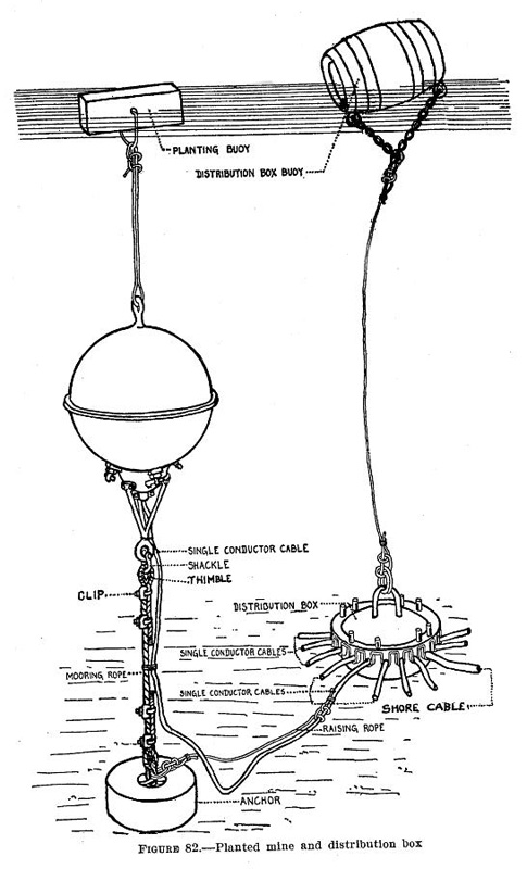
The modern era of defending American harbors with controlled mines or Naval mine, submarine mines (originally referred to as "torpedoes") began in the post-Civil War period, and was a major part of US Seacoast defense in the United States, harbor defenses from circa 1900 to 1947. Brief history In 1866, the United States Army Corps of Engineers established the U.S. Army Engineer School, Engineer School of Application at Fort Totten (Queens), Willets Point, New York. The first commander of this school, Major Henry Larcom Abbot, was almost single-handedly responsible for designing and supervising the program of research and development that defined the strategy and tactics for the mine defense of American harbors. Abbot experimented with underwater explosives, fuzes, cabling, and electrical equipment for over a decade before publishing the first manuals on the use of mines in coast defense in 1876–77. At least one experimental controlled minefield was emplaced at this time, at Fort ... [...More Info...] [...Related Items...] OR: [Wikipedia] [Google] [Baidu] |
Cape May
Cape May consists of a peninsula and barrier island system in the U.S. state of New Jersey. It is roughly coterminous with Cape May County and runs southwards from the New Jersey mainland, separating Delaware Bay from the Atlantic Ocean. The southernmost point in both New Jersey and the northeastern United States lies on the cape. A number of resort communities line the Atlantic side of the cape, including Ocean City, the most populous community on the cape, The Wildwoods, known for its architecturally significant hotel district, and the city of Cape May, which has served as a resort community since the mid-1700s, making it the oldest such resort in the U.S. As 2024, the population is 2,757 with 90% being white. Etymology The peninsula is named for Cornelius Jacobsen May, a Dutch explorer who worked for the Dutch East India Company. Geography and ecology The peninsula comprises the municipalities of Avalon, Cape May, Cape May Point, Dennis Township, Lower Towns ... [...More Info...] [...Related Items...] OR: [Wikipedia] [Google] [Baidu] |


