|
Edwin Dolby
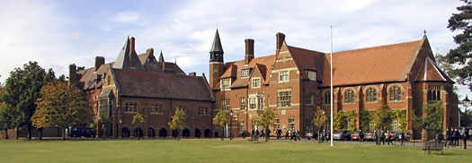
Edwin Dolby was an English Victorian architect who practised in Abingdon. His works include the design of Abingdon School. Career According to census records Dolby was born in Sutton Bonington, Nottinghamshire. By 1869 he working from 2 Bedwell Place, East St Helen Street, Abingdon, then in Berkshire. His known works span the period 1863–88. Dolby altered, rebuilt or restored a number of Anglican parish churches. Many of them were in the Vale of White Horse (then part of Berkshire) and Oxfordshire, but he also rebuilt two churches in Pembrokeshire. Drawings for one of the latter, at Castlebythe, were published in the ''Church Builder'' in 1867. In 1869–70 he built Abingdon School, described in ''The Builder'' as "of a simple character, the local material of red brick and tile being the chief material employed, relieved by bands of Bath stone". In 1877–78 Dolby worked with the architect H.J. Tollit of Oxford, rebuilding the parish churches at Watlington and Crowell, ... [...More Info...] [...Related Items...] OR: [Wikipedia] [Google] [Baidu] |
Christ's Hospital Of Abingdon
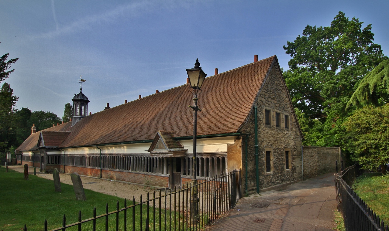
Christ's Hospital of Abingdon is a charity with a long history, based in Abingdon-on-Thames, Oxfordshire (formerly Berkshire). History A royal charter established the Master and Governors of the Hospital of Christ of Abingdon in 1553, the year that Mary I succeeded to the English throne. Sir John Mason, a Tudor diplomat, was its first Master from 1553 to 1566. The charity supports almshouses in Abingdon. Sampson Strong decorated the hall with portraits of founders, benefactors and former governors. The charity has been involved with education, educating Abingdon boys from 1608 until 1870. There has been a close connection with Abingdon School since 1870. Christ's Hospital established Albert Park in northwest Abingdon (west of Abingdon School) in the 1860s on the site of the former Conduit Field. The current charity is based at St Helen's Wharf in Abingdon, Registered Charity Number 205112. Names of Masters The following list contains the names of the Masters. See ... [...More Info...] [...Related Items...] OR: [Wikipedia] [Google] [Baidu] |
Thame Town Hall
Thame Town Hall is a municipal building in the High Street, Thame, Oxfordshire, England. The town hall, which is the meeting place of Thame Town Council, is a Grade II listed building. History A moot hall, which was designed with arcading on the ground floor to allow markets to be held, was erected in the Middle Row (between the Buttermarket to the north and the Cornmarket to the south) in the High Street in 1509. After the moot hall fell into a state of disrepair, a second market hall, which was also arcaded and featured a clock tower, was commissioned by the James Bertie, 1st Earl of Abingdon in 1684. In the late 1850s, following complaints that the 17th century market hall was inadequate for large public meetings, civic leaders decided to acquire the old building from Montagu Bertie, 6th Earl of Abingdon, to demolish it and to erect a new town hall, financed by public subscription, on the same site as part of the town's celebrations for the Golden Jubilee of Queen Victoria. Th ... [...More Info...] [...Related Items...] OR: [Wikipedia] [Google] [Baidu] |
Kingston Bagpuize
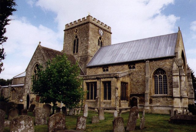
Kingston Bagpuize () is a village in the civil parish of Kingston Bagpuize with Southmoor, about west of Abingdon. It was part of Berkshire, England, until the 1974 boundary changes transferred it to Oxfordshire. The 2011 Census recorded the population of Kingston Bagpuize with Southmoor as 2,349. Geography The village is next to the junction of the A420 (Oxford–Swindon) and A415 ( Abingdon–Witney) main roads. It is contiguous with Southmoor village to the west and about southeast of Longworth village. History The toponym Kingston Bagpuize is derived from the village's original name Kingston plus the surname of Ralph de Bachepuz, a Norman nobleman from Bacquepuis in Normandy who aided William of Normandy in the Norman conquest of England in 1066. The Church of England parish church of Saint John the Baptist was designed by John Fidel of Faringdon and built in 1799–1800. The building was remodelled in 1882 to the designs of Edwin Dolby. Kingston Bagpuize House wa ... [...More Info...] [...Related Items...] OR: [Wikipedia] [Google] [Baidu] |
Garford
Garford is a village and civil parish about west of Abingdon. It was part of Berkshire until the 1974 boundary changes transferred it to Oxfordshire. The parish is bounded by the River Ock to the north, by two tributaries of the Ock to the south (Childrey Brook and Nor Brook), and by field boundaries and the road between Kingston Bagpuize and West Hanney to the west. The 2011 Census recorded the parish's population as 229. Archaeology The course of a Roman road passes through the parish about east of the village. Manor Garford's toponym evolved from ''Garanford'' in the 10th century to ''Wareford'' in the 11th century before reaching its current form. In 940 Edmund I gave 15 houses at Garford to his thegn Wulfric, and in 960 Edmund's son Edgar the Peaceful confirmed the grant. The Benedictine Abingdon Abbey held two hides of land at Garford by the time of the Norman Conquest of England in 1066. Apart from brief interruptions during the reign of William II the Abbey ... [...More Info...] [...Related Items...] OR: [Wikipedia] [Google] [Baidu] |
Drayton, Vale Of White Horse
Drayton is a village and civil parish about south of Abingdon, Oxfordshire. It was part of Berkshire until the 1974 boundary changes transferred it to Oxfordshire. The parish includes the hamlet of Sutton Wick. The 2011 Census recorded the parish population as 2,353. Archaeology Two sites of former settlements in the parish are scheduled monuments. One is about north of the village at Sutton Wick, overlapping the parish boundary with Abingdon. The other is around Brook Farm, about southeast of the village. An episode of the Channel 4 television series ''Time Team'' called "In the Halls of a Saxon King", first transmitted on 5 September 2010, investigated archaeological sites from various periods between Drayton and its eastern neighbour Sutton Courtenay. They included a Neolithic site called the Drayton Cursus. In 1965 a late Saxon sword was found during ploughing on a field beside Barrow Lane. It is similar to swords found at Windsor, Berkshire and Gooderstone, Suffol ... [...More Info...] [...Related Items...] OR: [Wikipedia] [Google] [Baidu] |
Drayton, Cherwell
Drayton is a village and civil parish in the valley of the Sor Brook in Oxfordshire, about northwest of Banbury. The 2011 Census recorded the parish's population as 242. Early history Tesselated tiles and Roman coins found near the parish church indicate that there was a Roman villa in the area of what later became Drayton village. Drayton village is Saxon in origin. Its toponym comes from the Old English ''drag'' meaning to carry goods. Manor After the Norman conquest of 1066, the conquering Normans dispossessed many Saxon landowners. However, the Domesday Book records that in 1086 Drayton still belonged to a Saxon thegn, Turchil of Arden. Two years later, in 1088, William the Conqueror created the Earldom of Warwick and thereafter gave Turchil's estates to the Norman nobleman Henry de Beaumont, 1st Earl of Warwick. The Arden family seems to have remained as tenants of the Earldom, for in 1204 a Thomas Arden held the tenancy. In 1329 Sir Robert Arden was licensed to cren ... [...More Info...] [...Related Items...] OR: [Wikipedia] [Google] [Baidu] |
Llanychaer
Llanychaer (English: church on the Aer, a tributary of the River Gwaun) is a small rural village and parish in the community of Cwm Gwaun, north Pembrokeshire, Wales. It is southeast of the port of Fishguard. History Llanychaer was in the ancient hundred of Cemais. Early in the 19th century the population was 176 and only half the land in the parish was enclosed. Later in the century, it was described as hilly, much of which was pasture, with the village consisting of a few farmhouses. Glandwr Baptist chapel in the village was built in 1894. The Reverend Carl D Williams, a well-known preacher in Wales, had been the minister for 28 years (in all, a minister for 50 years) until his retirement in 2010. Features There are two bridges crossing the Gwaun in the north of the parish: at Cilrhedyn and Llanychaer. A disused mill close to the latter is recorded at the end of the 19th century. Parish The parish is in the Diocese of St Davids, absorbed with two other parishes into the l ... [...More Info...] [...Related Items...] OR: [Wikipedia] [Google] [Baidu] |
Lynmouth
Lynmouth is a village in Devon, England, on the northern edge of Exmoor. The village straddles the confluence of the West Lyn and East Lyn rivers, in a gorge below Lynton, which was the only place to expand to once Lynmouth became as built-up as possible. The villages are connected by the Lynton and Lynmouth Cliff Railway, which works two cable-connected cars by gravity, using water tanks. The two villages are a civil parish governed by Lynton and Lynmouth Town Council. The parish boundaries extend southwards from the coast, and include hamlets such as Barbrook and small moorland settlements such as East Ilkerton, West Ilkerton and Shallowford. The South West Coast Path and Tarka Trail pass through, and the Two Moors Way runs from Ivybridge in South Devon to Lynmouth; the Samaritans Way South West runs from Bristol to Lynton, and the Coleridge Way from Nether Stowey to Lynmouth. Lynmouth was described by Thomas Gainsborough, who honeymooned there with his bride Margare ... [...More Info...] [...Related Items...] OR: [Wikipedia] [Google] [Baidu] |
Headley, Basingstoke And Deane
Headley is a village in Hampshire, England. It is close to the county boundary with Berkshire and about south-east of Newbury, Berkshire, Newbury. Governance The village of Headley is part of the civil parish of Ashford Hill with Headley and is part of the Kingsclere Wards of the United Kingdom, ward of the Basingstoke and Deane, Borough of Basingstoke and Deane. References Villages in Hampshire {{hampshire-geo-stub ... [...More Info...] [...Related Items...] OR: [Wikipedia] [Google] [Baidu] |
Claydon, Oxfordshire
Claydon is a village in Claydon with Clattercot Civil parishes in England, civil parish, about north of Banbury in Oxfordshire. The village is about above sea level on a hill of Early Jurassic Lias Group, Middle Lias clay. The village is the northernmost settlement in Oxfordshire and as such is also the northernmost settlement in the entire South East England region. The parish is bounded by Warwickshire to the west and Northamptonshire to the east. The United Kingdom Census 2011, 2011 Census recorded the parish's population as 306. Church and chapel Church of England The Church of England parish church of James, son of Zebedee, Saint James the Great was a Chapel of ease, dependent chapelry of the parish of Cropredy until 1851. St. James' was originally Norman architecture, Norman, built in about AD 1100. The Arcade (architecture), arcade between the nave and north Aisle#Architecture, aisle survives from this date, as does the south doorway. Slightly later a chapel was added ... [...More Info...] [...Related Items...] OR: [Wikipedia] [Google] [Baidu] |
Wantage
Wantage () is a historic market town and civil parish in Oxfordshire, England. Although within the boundaries of the historic county of Berkshire, it has been administered as part of the Vale of White Horse district of Oxfordshire since 1974. The town is on Letcombe Brook, south-west of Abingdon, north-west of Reading, south-west of Oxford and north-west of Newbury. It was the birthplace of King Alfred the Great in 849. History Wantage was a small Roman settlement but the origin of the toponym is somewhat uncertain. It is generally thought to be from an Old English phrase meaning "decreasing river". King Alfred the Great was born at the royal palace there in the 9th century, in what was originally known as Wanating. Wantage appears in the Domesday Book of 1086. Its value was £61 and it was in the king's ownership until Richard I passed it to the Earl of Albemarle in 1190. Weekly trading rights were first granted to the town by Henry III in 1246. Markets are now held ... [...More Info...] [...Related Items...] OR: [Wikipedia] [Google] [Baidu] |
Lynmouth (Devon, UK), St John The Baptist's Church -- 2013 -- 1482
Lynmouth is a village in Devon, England, on the northern edge of Exmoor. The village straddles the confluence of the West Lyn and East Lyn rivers, in a gorge below Lynton, which was the only place to expand to once Lynmouth became as built-up as possible. The villages are connected by the Lynton and Lynmouth Cliff Railway, which works two cable-connected cars by gravity, using water tanks. The two villages are a civil parish governed by Lynton and Lynmouth Town Council. The parish boundaries extend southwards from the coast, and include hamlets such as Barbrook and small moorland settlements such as East Ilkerton, West Ilkerton and Shallowford. The South West Coast Path and Tarka Trail pass through, and the Two Moors Way runs from Ivybridge in South Devon to Lynmouth; the Samaritans Way South West runs from Bristol to Lynton, and the Coleridge Way from Nether Stowey to Lynmouth. Lynmouth was described by Thomas Gainsborough, who honeymooned there with his bride Margar ... [...More Info...] [...Related Items...] OR: [Wikipedia] [Google] [Baidu] |


.jpg)


