|
East Los Angeles Interchange
The East Los Angeles Interchange is an interchange complex located in Boyle Heights, California, approximately 2.5 miles (4 km) east of Downtown Los Angeles. With its southern portion handling over 550,000 vehicles per day (2008 AADT), it is the busiest freeway interchange in the world. The northern portion, called the San Bernardino Split, is often considered a separate interchange. Four numbered routes converge at the interchange: Interstate 5 (I-5), I-10, U.S. Route 101 (US 101), and State Route 60 (SR 60), but the freeway segments shift alignments and directions. The interchange was named the Eugene A. Obregon Memorial Interchange, to honor U.S. Marine Corps member and Medal of Honor recipient Eugene A. Obregon. Description At the time of its construction in the early 1960s, the East Los Angeles Interchange was considered a civil engineering marvel. Located along the east bank of the Los Angeles River in the Los Angeles district of Boyle Heights, ... [...More Info...] [...Related Items...] OR: [Wikipedia] [Google] [Baidu] |
California Department Of Transportation
The California Department of Transportation (Caltrans) is an executive department of the U.S. state of California. The department is part of the cabinet-level California State Transportation Agency (CalSTA). Caltrans is headquartered in Sacramento. Caltrans manages the state's highway system, which includes the California Freeway and Expressway System, supports public transportation systems throughout the state and provides funding and oversight for three state-supported Amtrak intercity rail routes (''Capitol Corridor'', ''Pacific Surfliner'' and ''San Joaquins'') which are collectively branded as ''Amtrak California''. In 2015, Caltrans released a new mission statement: "Provide a safe, sustainable, integrated and efficient transportation system to enhance California’s economy and livability." History The earliest predecessor of Caltrans was the Bureau of Highways, which was created by the California Legislature and signed into law by Governor James Budd in 1895.Raymon ... [...More Info...] [...Related Items...] OR: [Wikipedia] [Google] [Baidu] |
San Bernardino Freeway
Interstate 10 (I-10) is a transcontinental Interstate Highway in the United States, stretching from Santa Monica, California to Jacksonville, Florida. The segment of I-10 in California runs east from Santa Monica through Los Angeles, San Bernardino, and Palm Springs before crossing into the state of Arizona. In the Greater Los Angeles area, it is known as the Santa Monica Freeway and the San Bernardino Freeway, linked by a short concurrency on I-5 (Golden State Freeway) at the East Los Angeles Interchange. I-10 also has parts designated as the Rosa Parks Freeway, the Redlands Freeway, and the Sonny Bono Memorial Freeway. Some parts were also formerly designated as the Christopher Columbus Transcontinental Highway. However, the California State Legislature removed this designation following the passage of a bill on August 31, 2022. I-10 is also known colloquially as "the 10" to Southern California residents . Route description The California Streets and Highways Code defines ... [...More Info...] [...Related Items...] OR: [Wikipedia] [Google] [Baidu] |
Road Interchanges In California
A road is a linear way for the conveyance of traffic that mostly has an improved surface for use by vehicles (motorized and non-motorized) and pedestrians. Unlike streets, the main function of roads is transportation. There are many types of roads, including parkways, avenues, controlled-access highways (freeways, motorways, and expressways), tollways, interstates, highways, thoroughfares, and local roads. The primary features of roads include lanes, sidewalks (pavement), roadways (carriageways), median strip, medians, shoulder (road), shoulders, road verge, verges, bike paths (cycle paths), and shared-use paths. Definitions Historically many roads were simply recognizable routes without any formal construction or some maintenance. The Organisation for Economic Co-operation and Development, Organization for Economic Co-operation and Development (OECD) defines a road as "a line of communication (travelled way) using a stabilized base other than rails or air strips open to ... [...More Info...] [...Related Items...] OR: [Wikipedia] [Google] [Baidu] |
Southern California Freeways
The Southern California freeways are a vast network of interconnected freeways in the megaregion of Southern California, serving a population of 23 million people. The Master Plan of Metropolitan Los Angeles Freeways was adopted by the Regional Planning Commission in 1947 and construction began in the early 1950s. The plan hit opposition and funding limitations in the 1970s, and by 2004, only some 61% of the original planned network had been completed. The region is well known for its freeways, and they are considered a cultural touchstone. History Origins Southern California's romance with the automobile owes in large part to resentment of the Southern Pacific Railroad's tight control over the region's commerce in the late 19th and early 20th centuries. During his successful campaign for governor in 1910, anti-Southern Pacific candidate Hiram Johnson traveled the state by car, which was no small feat at that time. In the minds of Southlanders, this associated the autom ... [...More Info...] [...Related Items...] OR: [Wikipedia] [Google] [Baidu] |
Jim Thornton
Jim Thornton is an American radio and television announcer and voice actor. He is known for his voiceover work in video games, movies and television shows. Since 2011, he is best known for being the announcer of '' Wheel of Fortune'' following the death of longtime announcer Charlie O'Donnell. Early life and education Born in Huntington, West Virginia, Thornton graduated from Huntington High School in 1983 and then moved to Los Angeles in 1984 where he started his broadcasting career a year later. He also has a degree in linguistics from Marshall University. Career Radio Thornton is best known as the afternoon anchor on all-news radio KNX 1070 in Los Angeles, having been promoted from traffic reporting. He has also announced on ''Celebrity Deathmatch'' and narrated a portion of '' Monsters, Inc.'' Game show announcer Thornton did substitute announcing work on ''The Price Is Right'' following the death of former announcer Rod Roddy. In December 2010, he auditioned for the sa ... [...More Info...] [...Related Items...] OR: [Wikipedia] [Google] [Baidu] |
Bill Keene
Bill Keene (1927 – April 5, 2000) was a television and radio personality who became famous in the Los Angeles, California market as a traffic and weather announcer. He was particularly known for his colorful humorous traffic reports which included numerous puns and he became a fixture in Los Angeles broadcasting. Keene first took to the airwaves while still in high school in his native Scottsbluff, Nebraska. After serving as an Army Air Corps navigator during World War II, he was hired as news and sports director at KBOL radio in Boulder, Colorado where he studied journalism at the University of Colorado. Keene's Los Angeles broadcasting career began in 1957 at KNXT-TV (now KCBS-TV) as a weather reporter. He is credited with helping pioneer the station's hourlong news format, promoted as ''The Big News'', which featured Keene with long time Los Angeles news anchor Jerry Dunphy and sports reporter Gil Stratton. During the same period he also reported the weather on the sister ... [...More Info...] [...Related Items...] OR: [Wikipedia] [Google] [Baidu] |
KNX (AM)
KNX (1070 Hertz, kHz) is a commercial radio, commercial AM radio, AM radio station in Los Angeles, Los Angeles, California. It airs an all news radio, all-news radio format and is owned by Audacy, Inc. KNX is one of the oldest stations in the United States, having received its first broadcasting license, as KGC, in December 1921, in addition to tracing its history to the September 1920 operations of an earlier amateur station. The radio studio, studios and offices—shared with KNX-FM, KCBS-FM, KROQ-FM, KRTH and KTWV—are located on Los Angeles' Miracle Mile, Los Angeles, California, Miracle Mile. KNX broadcasts traffic reports on the freeways in the Greater Los Angeles Area every ten minutes on the five's along with weather reports twenty-four hours a day, seven days a week, while other radio stations broadcast traffic reports weekday mornings and evenings. KNX holds a List of broadcast station classes, Class A license as one of the original clear-channel stations allocated ... [...More Info...] [...Related Items...] OR: [Wikipedia] [Google] [Baidu] |
Spaghetti Junction
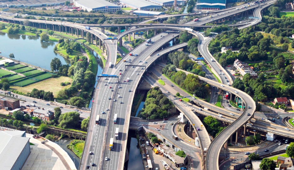
Spaghetti junction is a nickname sometimes given to a complex or massively intertwined road traffic interchange that is said to resemble a plate of spaghetti. Such interchanges may incorporate a variety of interchange design elements in order to maximize connectivity. Etymology The term was originally used to refer to the Gravelly Hill Interchange on the M6 motorway in Birmingham, United Kingdom. In an article published in the ''Birmingham Evening Mail'' on 1 June 1965 the journalist Roy Smith described plans for the junction as "like a cross between a plate of spaghetti and an unsuccessful attempt at a Staffordshire knot", with the headline above the article on the newspaper's front page, written by sub-editor Alan Eaglesfield, reading "Spaghetti Junction". Since then many complex interchanges around the world have acquired the nickname. Throughout North America, this type of interchange is widely referred to as a spaghetti junction, mixing bowl, knot, or maze, often inclu ... [...More Info...] [...Related Items...] OR: [Wikipedia] [Google] [Baidu] |
East LA Interchange 1959 LA River Bridge Construction
East or Orient is one of the four cardinal directions or points of the compass. It is the opposite direction from west and is the direction from which the Sun rises on the Earth. Etymology As in other languages, the word is formed from the fact that east is the direction where the Sun rises: ''east'' comes from Middle English ''est'', from Old English ''ēast'', which itself comes from the Proto-Germanic *''aus-to-'' or *''austra-'' "east, toward the sunrise", from Proto-Indo-European *aus- "to shine," or "dawn", cognate with Old High German ''*ōstar'' "to the east", Latin ''aurora'' 'dawn', and Greek ''ēōs'' 'dawn, east'. Examples of the same formation in other languages include Latin oriens 'east, sunrise' from orior 'to rise, to originate', Greek ανατολή anatolé 'east' from ἀνατέλλω 'to rise' and Hebrew מִזְרָח mizraḥ 'east' from זָרַח zaraḥ 'to rise, to shine'. ''Ēostre'', a Germanic goddess of dawn, might have been a personificatio ... [...More Info...] [...Related Items...] OR: [Wikipedia] [Google] [Baidu] |
Dosan Ahn Chang Ho Memorial Interchange
The Dosan Ahn Chang Ho Memorial Interchange, also known as the Harbor–Santa Monica Freeway Interchange, is a three-level cloverstack interchange that serves as the junction between the Harbor ( Interstate 110 and State Route 110) and Santa Monica (Interstate 10) Freeways at the southern edge of Downtown Los Angeles, California. Officially named since 2002 after Korean independence activist Ahn Chang Ho, and constructed as part of the first segment of the Santa Monica Freeway which was completed in 1962, it is one of the busiest freeway interchanges in Los Angeles, with hundreds of thousands of vehicles using the interchange daily. History Planning for the construction of the Santa Monica Freeway originally did not account for the construction of an interchange with the Harbor Freeway. In 1955, it was initially planned that the freeway would terminate at the Harbor Freeway, as opposed to its original alignment through Downtown Los Angeles, without necessarily connecting to it ... [...More Info...] [...Related Items...] OR: [Wikipedia] [Google] [Baidu] |
Interstate 110 And State Route 110 (California)
Route 110, consisting of State Route 110 (SR 110) and Interstate 110 (I-110), is a state and auxiliary Interstate Highway in the Los Angeles metropolitan area of the US state of California. The entire route connects San Pedro and the Port of Los Angeles with Downtown Los Angeles and Pasadena. The southern segment from San Pedro to I-10 in downtown Los Angeles is signed as I-110, while the northern segment to Pasadena is signed as SR 110. The entire length of I-110, as well as SR 110 south of the Four Level Interchange with US Route 101 (US 101), is the Harbor Freeway, and SR 110 north from US 101 to Pasadena is the historic Arroyo Seco Parkway, the first freeway in the western United States. Route description Route 110 is part of the California Freeway and Expressway System, and is part of the National Highway System, a network of highways that are considered essential to the country's economy, defense, and mobility ... [...More Info...] [...Related Items...] OR: [Wikipedia] [Google] [Baidu] |
Interstate 710 (California)
Route 710, consisting of the non-contiguous segments of State Route 710 (SR 710) and Interstate 710 (I-710), is a major north–south state highway and auxiliary Interstate Highway in the Los Angeles metropolitan area of the U.S. state of California. Also called the Los Angeles River Freeway prior to November 18, 1954, the highway was initially planned to connect Long Beach and Pasadena, but a gap in the route exists from Alhambra to Pasadena through South Pasadena due to community opposition to its construction. The completed southern segment is signed as I-710 and is officially known as the Long Beach Freeway, and it runs north from Long Beach to Valley Boulevard, just north of I-10 (San Bernardino Freeway), near the boundary between the cities of Alhambra and Los Angeles. South of I-5, I-710 follows the course of the Los Angeles River, rarely wandering more than a few hundred feet from the riverbed. South of SR 1 in Long Beach, I-710 is officia ... [...More Info...] [...Related Items...] OR: [Wikipedia] [Google] [Baidu] |


.jpg)

