|
Eaglehawk Neck, Tasmania
Eaglehawk Neck, officially Teralina / Eaglehawk Neck, is a narrow isthmus that connects the Tasman Peninsula with the Forestier Peninsula, and hence to mainland Tasmania, Australia. The locality of Eaglehawk Neck is in the local government area of Tasman in the South-east region of Tasmania. The locality is about north-east of the town of Nubeena. At the , the settlement of Eaglehawk Neck had a population of 385. Location and features Locally known as "the Neck", the isthmus itself is around long and under wide at its narrowest point. The area features rugged terrain and several unusual geological formations. These include the Tessellated Pavement, an area of flat rock that looks to be manmade but is in fact formed by erosion. A short walk further via Lufra Cove leads to Clyde Island, accessible for crossings at low tide, which sits at the northern entry to Pirates Bay. The island hosts two grave sites, and a rumbling blow hole cleaves the island. Eaglehawk Neck is a wel ... [...More Info...] [...Related Items...] OR: [Wikipedia] [Google] [Baidu] |
Martin Cash
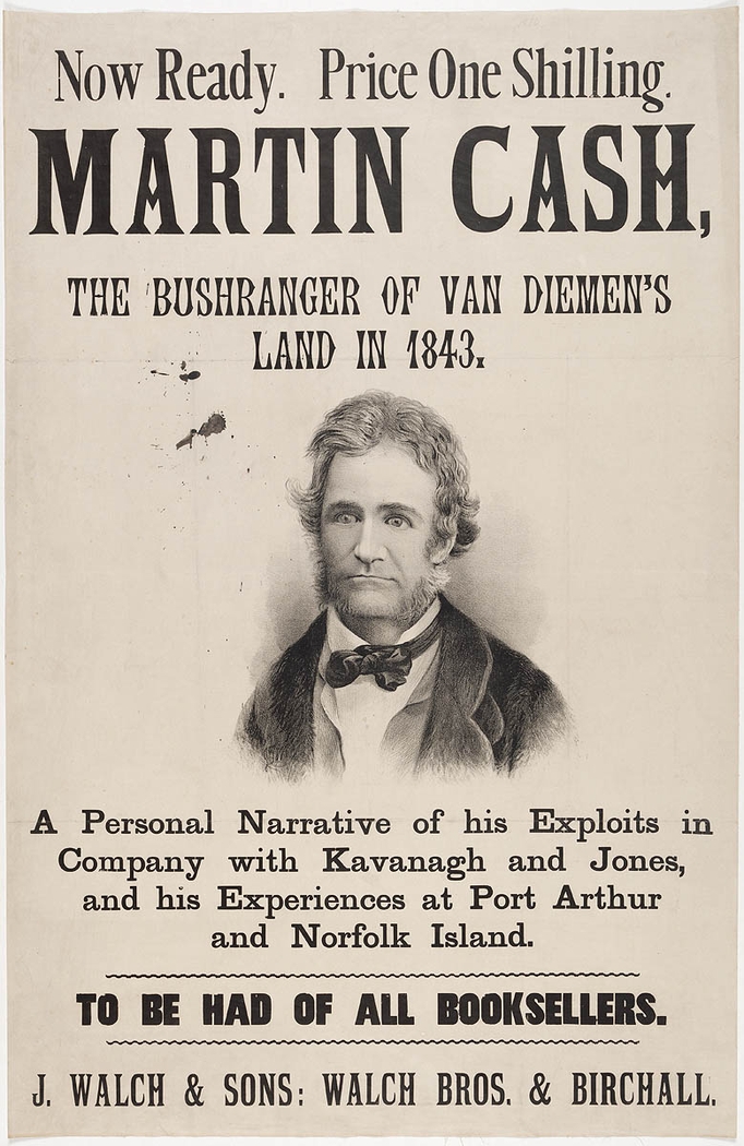
Martin Cash (baptised 10 October 1808 – 26 August 1877) was a notorious Irish-Australian convict bushranger, known for escaping twice from Port Arthur, Van Diemen's Land. His 1870 autobiography, ''The Adventures of Martin Cash'', ghostwritten by James Lester Burke, also a former convict, became a best seller in Australia. Biography Born in Enniscorthy, County Wexford, Ireland, Cash was brought up in a wealthy family and was literate. When he was 18 years old, he became acquainted with a young woman from Enniscorthy who earned a living by making straw hats and bonnets. She and her family borrowed money from him, until his mother stopped him as this extravagance was rapidly draining her resources. Subsequently, he became involved in an event which changed the whole course of his life. His memoirs describe that, in a jealous rage, he shot at a man named Jessop for making advances to the above-mentioned young lady. Cash was sentenced to seven years penal transportation, and h ... [...More Info...] [...Related Items...] OR: [Wikipedia] [Google] [Baidu] |
British Empire
The British Empire was composed of the dominions, colonies, protectorates, mandates, and other territories ruled or administered by the United Kingdom and its predecessor states. It began with the overseas possessions and trading posts established by England between the late 16th and early 18th centuries. At its height it was the largest empire in history and, for over a century, was the foremost global power. By 1913, the British Empire held sway over 412 million people, of the world population at the time, and by 1920, it covered , of the Earth's total land area. As a result, its constitutional, legal, linguistic, and cultural legacy is widespread. At the peak of its power, it was described as "the empire on which the sun never sets", as the Sun was always shining on at least one of its territories. During the Age of Discovery in the 15th and 16th centuries, Portugal and Spain pioneered European exploration of the globe, and in the process established large overse ... [...More Info...] [...Related Items...] OR: [Wikipedia] [Google] [Baidu] |
Towns In Tasmania
A town is a human settlement. Towns are generally larger than villages and smaller than cities, though the criteria to distinguish between them vary considerably in different parts of the world. Origin and use The word "town" shares an origin with the German word , the Dutch word , and the Old Norse . The original Proto-Germanic word, *''tūnan'', is thought to be an early borrowing from Proto-Celtic *''dūnom'' (cf. Old Irish , Welsh ). The original sense of the word in both Germanic and Celtic was that of a fortress or an enclosure. Cognates of ''town'' in many modern Germanic languages designate a fence or a hedge. In English and Dutch, the meaning of the word took on the sense of the space which these fences enclosed, and through which a track must run. In England, a town was a small community that could not afford or was not allowed to build walls or other larger fortifications, and built a palisade or stockade instead. In the Netherlands, this space was a garden, more ... [...More Info...] [...Related Items...] OR: [Wikipedia] [Google] [Baidu] |
Geography Of Tasmania
Tasmania, the largest island of Australia, has a landmass of and is located directly in the pathway of the notorious "Roaring Forties" wind that encircles the globe. To its north, it is separated from mainland Australia by Bass Strait. Tasmania is the only Australian state that is not located on the Australian mainland. About south of Tasmania island lies the George V Coast of Antarctica. Depending on which borders of the oceans are used, the island can be said to be either surrounded by the Southern Ocean, or to have the Pacific on its east and the Indian to its west. Still other definitions of the ocean boundaries would have Tasmania with the Great Australian Bight to the west, and the Tasman Sea to the east. The southernmost point on mainland Tasmania is approximately at South East Cape, and the northernmost point on mainland Tasmania is approximately in Woolnorth / Temdudheker near Cape Grim / Kennaook. Tasmania lies at similar latitudes to Te Waipounamu / South Island of ... [...More Info...] [...Related Items...] OR: [Wikipedia] [Google] [Baidu] |
Clydes Island
Clydes Island is an island in south-eastern Australia. It is part of the Tasman Island Group, lying close to the south-eastern coast of Tasmania around the Tasman Peninsula The Tasman Peninsula, officially Turrakana / Tasman Peninsula, is a peninsula located in south-east Tasmania, Australia, approximately by the Arthur Highway, south-east of Hobart. The Tasman Peninsula lies south and west of Forestier Peninsula ..., and is easily accessible from mainland Tasmania.Brothers ''et al'' (2001), p.606. References Notes Sources * Brothers, Nigel; Pemberton, David; Pryor, Helen; & Halley, Vanessa. (2001). ''Tasmania’s Offshore Islands: seabirds and other natural features''. Tasmanian Museum and Art Gallery: Hobart. Islands of Tasmania {{Tasmania-geo-stub ... [...More Info...] [...Related Items...] OR: [Wikipedia] [Google] [Baidu] |
Tasman Sea
The Tasman Sea (Māori: ''Te Tai-o-Rēhua'', ) is a marginal sea of the South Pacific Ocean, situated between Australia and New Zealand. It measures about across and about from north to south. The sea was named after the Dutch explorer Abel Janszoon Tasman, who in 1642 was the first known person to cross it. British explorer Lieutenant James Cook later extensively navigated the Tasman Sea in the 1770s during his three voyages of exploration. The Tasman Sea is informally referred to in both Australian and New Zealand English as the Ditch; for example, "crossing the Ditch" means travelling to Australia from New Zealand, or vice versa. The diminutive term "the Ditch" used for the Tasman Sea is comparable to referring to the North Atlantic Ocean as "the Pond". Climate The south of the sea is passed over by depressions going from west to east. The northern limit of these westerly winds is near to 40°S. During the southern winter, from April to October, the northern branch ... [...More Info...] [...Related Items...] OR: [Wikipedia] [Google] [Baidu] |
Norfolk Bay (Tasmania)
The Norfolk Bay is a body of water in the south east of Tasmania, Australia. The north west aspect of Norfolk Bay is continuous with Frederick Henry Bay. The north east aspect of Norfolk Bay is continuous with Blackman Bay via the Denison Canal. History The first recorded Anglo-Saxon encounter with Norfolk bay was by Matthew Flinders in 1798. :"Norfolk Bay was discovered by Willaumetz, an officer of D'Entrecasteaux, in 1792, who becoming short of provisions, could only get as far as Primrose Point. He did not know then whether this new bay had communication with Tasman's Frederick Hendrick Bay (Blackman's, or Marion Bay) ; and on D'Entrecasteaux's map Tasman Peninsula is called Tasman Island. Flinders in 1798 (''the source erroneously states 1878'') visited the Bay, giving it the name of Norfolk, after the small schoonerin which he was sailing with Bass. In 1802 Baudin examined the bay, and, unaware of Flinders's nomenclature, gave it the name of Port Buache, after the Fr ... [...More Info...] [...Related Items...] OR: [Wikipedia] [Google] [Baidu] |
Penal Transportation
Penal transportation or transportation was the relocation of convicted criminals, or other persons regarded as undesirable, to a distant place, often a colony, for a specified term; later, specifically established penal colonies became their destination. While the prisoners may have been released once the sentences were served, they generally did not have the resources to return home. Origin and implementation Banishment or forced exile from a polity or society has been used as a punishment since at least the 5th century BC in Ancient Greece. The practice of penal transportation reached its height in the British Empire during the 18th and 19th centuries. Transportation removed the offender from society, mostly permanently, but was seen as more merciful than capital punishment. This method was used for criminals, debtors, military prisoners, and political prisoners. Penal transportation was also used as a method of colonization. For example, from the earliest days of English ... [...More Info...] [...Related Items...] OR: [Wikipedia] [Google] [Baidu] |
Australian Convict Sites
Australian Convict Sites is a World Heritage property consisting of 11 remnant penal sites originally built within the British Empire during the 18th and 19th centuries on fertile Australian coastal strips at Sydney, Tasmania, Norfolk Island, and Fremantle; now representing "...the best surviving examples of large-scale convict transportation and the colonial expansion of European powers through the presence and labour of convicts." These properties were all individually included on the Australian National Heritage List before inclusion on the World Heritage list. Preparations began in 1995, and a World Heritage nomination was first made in January 2008. That attempt failed, and the nomination was subsequently reworked. Penal sites included The 11 penal sites constituting the Australian Convict Sites World Heritage listed property are: # Kingston and Arthur's Vale Historic Area ("KAVHA"), Norfolk Island. # Old Government House and Domain ("Old Government House"), New S ... [...More Info...] [...Related Items...] OR: [Wikipedia] [Google] [Baidu] |
Arthur Highway
The Arthur Highway (A9) is a Tasmanian highway which runs from Sorell in the near south to Port Arthur in the far south-east. Route description From its intersection with the Tasman Highway in Sorell the highway runs east, crossing Iron Creek before turning south-east to Forcett. From there it continues in an easterly direction, crossing the Carlton River, to Copping, where it turns south to Dunalley. Here it crosses the Denison Canal via a swing bridge to the Forestier Peninsula, before continuing south-east to Eaglehawk Neck, the entry to the Tasman Peninsula. After following the southern shore of Eaglehawk Bay to the west the highway turns south and continues in that direction to Port Arthur where it transitions to route B37 (Nubeena Road). History Port Arthur (the town) was named for George Arthur, the lieutenant governor of Van Diemen’s Land. It is likely that the name of the highway was derived from this source. The first "proper" crossing of the Carlton River, n ... [...More Info...] [...Related Items...] OR: [Wikipedia] [Google] [Baidu] |
William Bannon
William Bannon ( – 27 February 1904) was an Irishman who served in the British 65th Regiment of Foot in the New Zealand Wars in the 1840s. In 1849 he was found guilty of desertion and theft and was sentenced to transportation for seven years to Van Diemen's Land (now Tasmania, Australia). A reward was posted for Bannon's capture after he escaped from a prison in Van Diemen's Land and, following his capture, he was transported to Norfolk Island before returning to Australia. "Murdering Gully Rd" at Table Cape, Tasmania is named after a murder that Bannon was accused of committing in 1858. Over his life, along with being found guilty on charges of desertion, theft, prison escape, extortion, and running an illegal distillery, Bannon was charged and acquitted of various crimes including murder and firearms offences. He was also the police's main suspect for various thefts. On one occasion Bannon secured his acquittal when the jury believed his testimony over that of the police, ... [...More Info...] [...Related Items...] OR: [Wikipedia] [Google] [Baidu] |
Port Arthur, Tasmania
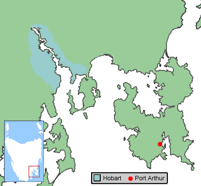
Port Arthur is a town and former convict settlement on the Tasman Peninsula, in Tasmania, Australia. It is located approximately southeast of the state capital, Hobart. The site forms part of the Australian Convict Sites, a World Heritage property consisting of 11 remnant penal sites originally built within the British Empire during the 18th and 19th centuries on fertile Australian coastal strips. Collectively, these sites, including Port Arthur, are described by UNESCO as "... the best surviving examples of large-scale convict transportation and the colonial expansion of European powers through the presence and labour of convicts." In 1996, the town was the scene of the Port Arthur Massacre, the worst instance of mass murder in post-colonial Australian history. Location Port Arthur is located about southeast of the state capital, Hobart, on the Tasman Peninsula. The scenic drive from Hobart, via the Tasman Highway to Sorell and the Arthur Highway to Port Arthur, takes a ... [...More Info...] [...Related Items...] OR: [Wikipedia] [Google] [Baidu] |


.jpg)


