|
Estuaries Of Texas
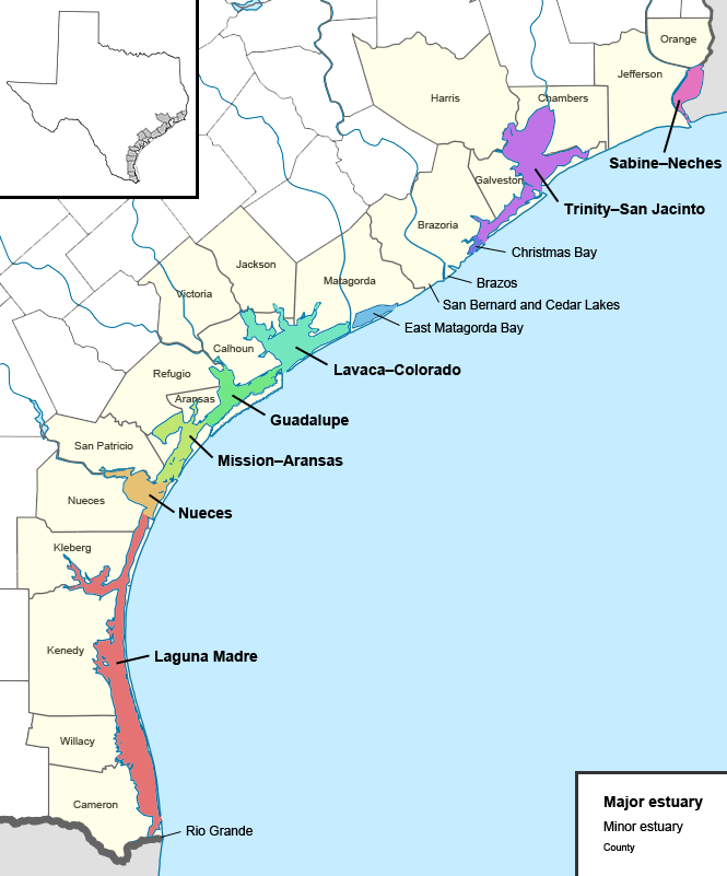
The U.S. state of Texas has a series of estuaries along its coast on the Gulf of Mexico, most of them bounded by the Texas barrier islands. Estuaries are coastal bodies of water in which freshwater from rivers mixes with saltwater from the sea. Twenty-one drainage basins terminate along the Texas coastline, forming a chain of seven major and five minor estuaries: listed from southwest to northeast, these are the Rio Grande Estuary, Laguna Madre, the Nueces Estuary (Corpus Christi Bay), the Mission– Aransas Estuary (Aransas Bay), the Guadalupe Estuary (San Antonio Bay), the Colorado– Lavaca Estuary (Matagorda Bay), East Matagorda Bay, the San Bernard River and Cedar Lakes Estuary, the Brazos River Estuary, Christmas Bay, the Trinity– San Jacinto Estuary (Galveston Bay), and the Sabine– Neches Estuary (Sabine Lake). Each estuary is named for its one or two chief contributing rivers, excepting Laguna Madre, East Matagorda Bay, and Christmas Bay, which have no major river so ... [...More Info...] [...Related Items...] OR: [Wikipedia] [Google] [Baidu] |
Texas Estuaries Map
Texas (, ; Spanish: ''Texas'', ''Tejas'') is a state in the South Central region of the United States. At 268,596 square miles (695,662 km2), and with more than 29.1 million residents in 2020, it is the second-largest U.S. state by both area (after Alaska) and population (after California). Texas shares borders with the states of Louisiana to the east, Arkansas to the northeast, Oklahoma to the north, New Mexico to the west, and the Mexican states of Chihuahua, Coahuila, Nuevo León, and Tamaulipas to the south and southwest; and has a coastline with the Gulf of Mexico to the southeast. Houston is the most populous city in Texas and the fourth-largest in the U.S., while San Antonio is the second most populous in the state and seventh-largest in the U.S. Dallas–Fort Worth and Greater Houston are, respectively, the fourth- and fifth-largest metropolitan statistical areas in the country. Other major cities include Austin, the second most populous state capital in the ... [...More Info...] [...Related Items...] OR: [Wikipedia] [Google] [Baidu] |
Colorado River (Texas)
The Colorado River is an approximately long river in the U.S. state of Texas. It is the 18th longest river in the United States and the longest river with both its source and its mouth within Texas. Its drainage basin and some of its usually dry tributaries extend into New Mexico. It flows generally southeast from Dawson County through Ballinger, Marble Falls, Lago Vista, Austin, Bastrop, Smithville, La Grange, Columbus, Wharton, and Bay City, before emptying into the Gulf of Mexico at Matagorda Bay. Course The Colorado River originates south of Lubbock, on the Llano Estacado near Lamesa. It flows generally southeast out of the Llano Estacado and through the Texas Hill Country, then through several reservoirs including Lake J.B. Thomas, E.V. Spence Reservoir, and O.H. Ivie Lake. The river flows through several more reservoirs before reaching Austin, including Lake Buchanan, Inks Lake, Lake Lyndon B. Johnson (commonly referred to as Lake LBJ), and Lake Travis. ... [...More Info...] [...Related Items...] OR: [Wikipedia] [Google] [Baidu] |
Sabine Lake
Sabine Lake is a bay on the Gulf coasts of Texas and Louisiana, located approximately east of Houston and west of Baton Rouge, adjoining the city of Port Arthur. The lake is formed by the confluence of the Neches and Sabine Rivers and connects to the Gulf of Mexico through Sabine Pass. It forms part of the Texas–Louisiana border, falling within Jefferson and Orange Counties in Texas and Cameron Parish, Louisiana. Sabine Lake is one of seven major estuaries along the Gulf Coast of Texas. Much of the Louisiana shore is protected by the Sabine National Wildlife Refuge. There is a long history of human habitation around the lake, including Native American settlement dating back at least 1,500 years, European exploration in the eighteenth century, and the growth of Port Arthur in the twentieth century. Today the lake serves as part of the Sabine–Neches Waterway and the Gulf Intracoastal Waterway and is a center for the shipping and petrochemical industries. History Archae ... [...More Info...] [...Related Items...] OR: [Wikipedia] [Google] [Baidu] |
Neches River
The Neches River () begins in Van Zandt County west of Rhine Lake and flows for through the piney woods of east Texas, defining the boundaries of 14 counties on its way to its mouth on Sabine Lake near the Rainbow Bridge. Two major reservoirs, Lake Palestine and B. A. Steinhagen Reservoir are located on the Neches. The Angelina River (containing Sam Rayburn Reservoir) is a major tributary with its confluence at the north of Lake B. A. Steinhagen. Tributaries to the south include Village Creek and Pine Island Bayou, draining much of the Big Thicket region, both joining the Neches a few miles north of Beaumont. Towns and cities located along the river including Tyler, Lufkin, and Silsbee, although significant portions of the Neches River are undeveloped and flow through protected natural lands.Phillips, Bob, (foreword). 2008. The Roads of Texas. MAPSCO Inc. Addison, Texas. 176 pp. In contrast, the lower 40 miles of the river are a major shipping channel, highly industria ... [...More Info...] [...Related Items...] OR: [Wikipedia] [Google] [Baidu] |
Sabine River (Texas–Louisiana)
The Sabine River () is a long riverU.S. Geological Survey. National Hydrography Dataset high-resolution flowline dataThe National Map accessed June 20, 2011 in the Southern U.S. states of Texas and Louisiana, From the 32nd parallel north and downstream, it serves as part of the boundary between the two states and empties into Sabine Lake, an estuary of the Gulf of Mexico. Over the first half of the 19th century, the river formed part of the Spanish–American, Mexican–American, and Texan–American international boundaries. The upper reaches of the river flow through the prairie country of northeast Texas. Along much of its lower reaches, it flows through pine forests along the Texas–Louisiana border, and eventually the bayou country near the Gulf Coast. The river drains an area of , of which are in Texas and in Louisiana. It flows through an area of abundant rainfall and discharges the largest volume of any river in Texas. The name Sabine ( es: ''Río de Sabinas'') ... [...More Info...] [...Related Items...] OR: [Wikipedia] [Google] [Baidu] |
Galveston Bay
Galveston Bay ( ) is a bay in the western Gulf of Mexico along the upper coast of Texas. It is the seventh-largest estuary in the United States, and the largest of seven major estuaries along the Texas Gulf Coast. It is connected to the Gulf of Mexico and is surrounded by sub-tropical marshes and prairies on the mainland. The water in the bay is a complex mixture of sea water and fresh water, which supports a wide variety of marine life. With a maximum depth of about and an average depth of only , it is unusually shallow for its size. The bay has played a significant role in the history of Texas. Galveston Island is home to the city of Galveston, the earliest major settlement in southeast Texas and the state's largest city toward the end of the nineteenth century. While a devastating hurricane in 1900 hastened Galveston's decline, the subsequent rise of Houston as a major trade center, facilitated by the dredging of the Houston Ship Channel across the western half of the bay ... [...More Info...] [...Related Items...] OR: [Wikipedia] [Google] [Baidu] |
San Jacinto River (Texas)
The San Jacinto River ( , ) flows through southeast Texas. It is named after Hyacinth of Caesarea, Saint Hyacinth. In the past, it was home to the Karankawa and Akokisa tribes. The river begins with a west and east fork; the west fork begins in Walker County, Texas, Walker County, to the west of Huntsville, Texas, Huntsville, and flows southeast through Montgomery County, Texas, Montgomery County, where it is dammed to create Lake Conroe. The east fork begins in San Jacinto County, Texas, San Jacinto County, a few miles west of Lake Livingston, then flows south through Cleveland, Texas, Cleveland. The confluence of the west and east forks occurs in northeast Harris County, Texas, Harris County, where the river is dammed to create Lake Houston. Continuing southward, the river merges with Buffalo Bayou before the mouth of Galveston Bay, forming part of the Houston Ship Channel. The Battle of San Jacinto was fought near the rain-swollen Buffalo Bayou in what is now Harris Count ... [...More Info...] [...Related Items...] OR: [Wikipedia] [Google] [Baidu] |
Trinity River (Texas)
The Trinity River is a river, the longest with a watershed entirely within the U.S. state of Texas. It rises in extreme northern Texas, a few miles south of the Red River. The headwaters are separated by the high bluffs on the southern side of the Red River. Indigenous peoples call the northern sections ''Arkikosa'' and the parts closer to the coast ''Daycoa''. French explorer Robert Cavelier de La Salle, in 1687, named it ''Riviere des canoës'' ("River of Canoes"). In 1690 Spanish explorer Alonso de León named the river ''"La Santísima Trinidad"'' ("the Most Holy Trinity"), in the Spanish Catholic practice of memorializing places by religious references. Course The Trinity River has four branches: the West Fork, the Clear Fork, the Elm Fork, and the East Fork. The West Fork Trinity River has its headwaters in Archer County. From there it flows southeast, through the man-made reservoirs Lake Bridgeport and Eagle Mountain Lake, and eastward through Lake Worth and the ... [...More Info...] [...Related Items...] OR: [Wikipedia] [Google] [Baidu] |
Christmas Bay (Texas)
Christmas Bay is a small bay located on the Texas Gulf Coast in Brazoria County, Texas, immediately southwest of West Bay, near the Galveston Bay system's southwest corner. It is a minor estuary, one of a series of estuaries along the Gulf Coast of Texas, and receives the discharge from Bastrop Bayou, along with the adjacent coastal watershed. The bay is separated from the Gulf of Mexico by Follet's Island and connects with it through San Luis Pass and Cold Pass. Its minor extensions are Bastrop Bay to the north and Drum Bay to the southwest. The nearest city is Freeport, about to the southwest at the mouth of the Brazos River. The bay has a surface area of and features high water quality, vast oyster reefs, and surrounding salt marsh habitat. The area has not been significantly impacted by human activities. Much of its shoreline is protected within the Brazoria National Wildlife Refuge. History Approximately 18 thousand years ago, the coast of the Gulf of Mexico took ... [...More Info...] [...Related Items...] OR: [Wikipedia] [Google] [Baidu] |
Brazos River
The Brazos River ( , ), called the ''Río de los Brazos de Dios'' (translated as "The River of the Arms of God") by early Spanish explorers, is the 11th-longest river in the United States at from its headwater source at the head of Blackwater Draw, Roosevelt County, New Mexico to its mouth at the Gulf of Mexico with a drainage basin. Being one of Texas' largest rivers,"Brazos River." Britannica Academic, Encyclopædia Britannica, 11 Aug. 2018. academic.eb.com/levels/collegiate/article/Brazos-River/16291. Accessed 27 Nov. 2018. it is sometimes used to mark the boundary between East Texas and West Texas. The river is closely associated with Texas history, particularly the Austin settlement and Texas Revolution eras. Today major Texas institutions such as Texas Tech University, Baylor University, and Texas A&M University are located close to the river's basin, as are parts of metropolitan Houston. Geography The Brazos proper begins at the confluence of the Salt Fork and Double ... [...More Info...] [...Related Items...] OR: [Wikipedia] [Google] [Baidu] |
Cedar Lakes (Texas)
The Cedar Lakes are a series of small lakes in geographic Palmer Township in the Unorganized North Part of Algoma in Northeastern Ontario, Canada. The lakes are in the Great Lakes Basin, and the primary inflow, at the north end of the series, and outflow, at the south end of the series, is the Carp River. The Carp River flows to Lake Superior. See also *List of lakes in Ontario This is an incomplete list of lakes in Ontario, a province of Canada. There are over 250,000 lakes in Ontario, constituting around 20% of the world's fresh water supply. Larger lake statistics This is a list of lakes of Ontario with an ar ... References Other map sources: * * Lakes of Algoma District {{NorthernOntario-geo-stub ... [...More Info...] [...Related Items...] OR: [Wikipedia] [Google] [Baidu] |
San Bernard River
The San Bernard River is a river in Texas. Course San Bernard River flows from a spring near New Ulm, TexasTexas Highways http://texashighways.com/travel/item/716-now-open-san-bernard-river to its mouth on the Gulf of Mexico, some to the southeast of the source. It passes through portions of Austin, Brazoria, Colorado, Fort Bend, Matagorda and Wharton counties. It passes alongside the Attwater Prairie Chicken National Wildlife Refuge, which shelters one of the last populations of the critically endangered Attwater's prairie-chicken, a ground-dwelling grouse of the coastal prairie ecosystem. The San Bernard River is one of a small number of rivers in Texas which empties directly into the Gulf. Its mouth was impeded in 2005 causing it to drain into the Gulf Intracoastal Waterway, but was later corrected. Shortly after being opened back up, the entrance silted in again, and remains so at this time. Watershed The San Bernard drains approximately 1,850 square miles (4 ... [...More Info...] [...Related Items...] OR: [Wikipedia] [Google] [Baidu] |


