|
Dwe'e People
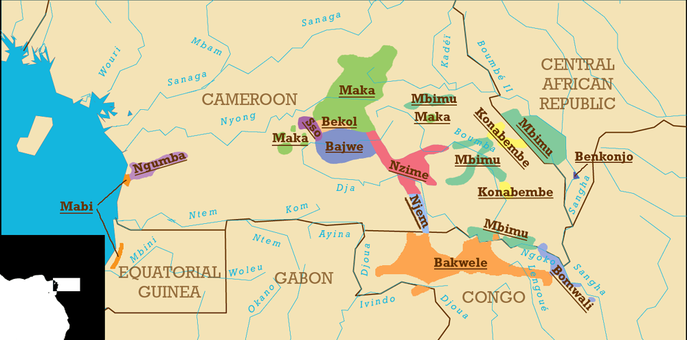
The Badwe'e (also ''Bajwe'e''; French ''Badjoué'') are an ethnic group inhabiting the rain forest zone of southeastern Cameroon. They recognize themselves as the descendants of Edwe'e, the youngest son of Koo and the brother of Njeme and Nzime. The Badwe'e live south of Messaména in the East Province in a region south of the Bekol and both north and west of the Nzime. Their territory includes much of the northern and western border of the Dja Biosphere Reserve. They speak a dialect of Koozime, together with the Nzime. History The ancestors of the Badwe'e lived in the Congo River basin or the present territory of Chad before moving into the present territory of Cameroon between the 14th and 17th centuries. Along with the other speakers of Makaa–Njyem languages, they lived along the northern Lom River near the present-day border between the Adamawa and East provinces. Under pressure from migrating Beti-Pahuin groups (themselves fleeing the Vute and Mbum), the Makaa†... [...More Info...] [...Related Items...] OR: [Wikipedia] [Google] [Baidu] |
Cameroon
Cameroon (; french: Cameroun, ff, Kamerun), officially the Republic of Cameroon (french: République du Cameroun, links=no), is a country in west-central Africa. It is bordered by Nigeria to the west and north; Chad to the northeast; the Central African Republic to the east; and Equatorial Guinea, Gabon and the Republic of the Congo to the south. Its coastline lies on the Bight of Biafra, part of the Gulf of Guinea and the Atlantic Ocean. Due to its strategic position at the crossroads between West Africa and Central Africa, it has been categorized as being in both camps. Its nearly 27 million people speak 250 native languages. Early inhabitants of the territory included the Sao civilisation around Lake Chad, and the Baka hunter-gatherers in the southeastern rainforest. Portuguese explorers reached the coast in the 15th century and named the area ''Rio dos Camarões'' (''Shrimp River''), which became ''Cameroon'' in English. Fulani soldiers founded the Adamawa Emirate ... [...More Info...] [...Related Items...] OR: [Wikipedia] [Google] [Baidu] |
Messaména
Messamena (also spelled Messaména) is a town and Communes of Cameroon, commune in Cameroon. Location The town of Messamena is the capital of the ''arrondissement'' (commune) of the same name. They are located in the Haut-Nyong, Haut-Nyong Department, East Region (Cameroon), East Region.Messamena , ''Communes et villes unies du Cameroun'' (2014) [based on Plan Communal de Developpement ' (Yaoundé: Centre de Reflexion et d'Action pour le Developpement Local, July 2012), pp. 15-25). The commune is bounded to the north by the commune of Atok, Cameroon, Atok (Maka-bebend), to the south by Somalomo, to the east b ... [...More Info...] [...Related Items...] OR: [Wikipedia] [Google] [Baidu] |
Mbum
Mbum Proper (also Mboum, Buna, Mboumtiba and Wuna) is a Adamawa–Ubangi language of Central Africa. It is spoken by about people in Cameroon and the Central African Republic. History The Mbum language is spoken by the Mbum people who inhabit Cameroon, the Central African Republic, and Chad. While their origins are unclear, some believe that the Mbum were one of the earliest ethnic groups of the Adamawa Region. The Mbum of Tibati claim to be ancestors of the Tikar people, who may have once been known as the ''Mboum'' people. However, this belief is disputed by some historians, linguists, and anthropologists who believe other groups attached themselves to the Tikar and Kirdi people as a political move to provide legitimacy to their claim of dynastic lineage. Professor and social anthropologist David Zeitlyn studied the theories of Tikar origin put forward by several historians, including Eldridge Mohammadou. Exploring those origin theories, Zeitlyn stated that "The main questio ... [...More Info...] [...Related Items...] OR: [Wikipedia] [Google] [Baidu] |
Vute
Vute is a Mambiloid language of Cameroon and Gabon, with a thousand speakers in Nigeria. The orthography was standardized on March 9, 1979. Noted dialect clusters are eastern, central, and Doume. Phonology Consonants Consonants in Vute are numerous and include pulmonic and implosive airstreams. Labialization is phonemic in many consonants, some of which is dialectal. Tones There are more phonemic tones than are marked in orthography, such as mid-high rising tone and mid tone being both unmarked for example. Phonologically conditioned downstep is unmarked. *Only in eastern dialects, on short vowels. All other dialects merge this class with low tone. Vowels * /É”/ only contrasts from /o/ in open syllables and before velar final consonants: /k/ and /Ĺ‹/. When preceding bilabial and alveolar final consonants, ”is understood to be an allophone In phonology, an allophone (; from the Greek , , 'other' and , , 'voice, sound') is a set of multiple possible spoken ... [...More Info...] [...Related Items...] OR: [Wikipedia] [Google] [Baidu] |
Beti-Pahuin
The Beti-Pahuin are a Bantu people, Bantu ethnic group located in rain forest regions of Cameroon, Republic of the Congo, Equatorial Guinea, Gabon, and SĂŁo TomĂ© and PrĂncipe. Though they separate themselves into several individual clans, they all share a common origin, history and culture Estimated to be well over 8 million individuals in the early 21st century, they form the largest ethnic group in central Cameroon and its capital city of YaoundĂ©, in Gabon, and in Equatorial Guinea. Their Beti language, Beti languages are Mutual intelligibility, mutually intelligible. Group distinctions The Beti-Pahuin are made up of over 20 individual clans. Altogether, they inhabit a territory of forests and rolling hills that stretches from the Sanaga River in the north to Equatorial Guinea and the northern halves of Gabon to Congo to the south, and from the Atlantic Ocean to the west to the Dja River in the east. Beti The first grouping, called the Beti, consists of the Ewondo (more pr ... [...More Info...] [...Related Items...] OR: [Wikipedia] [Google] [Baidu] |
East Province (Cameroon)
The East Region (french: RĂ©gion de l'Est) occupies the southeastern portion of the Republic of Cameroon. It is bordered to the east by the Central African Republic, to the south by Congo, to the north by the Adamawa Region, and to the west by the Centre and South Regions. With 109,002 km2 of territory, it is the largest region in the nation as well as the most sparsely populated. Historically, the peoples of the East have been settled in Cameroonian territory for longer than any other of the country's many ethnic groups, the first inhabitants being the Baka (or Babinga) pygmies. The East Region has very little industry, its main commerce consisting of logging, timber, and mining. Instead, the bulk of its inhabitants are subsistence farmers. The region is thus of little political import and is often ignored by Cameroonian politicians. This coupled with the low level of development in the province have led to its being dubbed "the forgotten province". The southwest region ... [...More Info...] [...Related Items...] OR: [Wikipedia] [Google] [Baidu] |
Adamawa Province
The Adamawa Region (french: RĂ©gion de l'Adamaoua) is a constituent region of the Republic of Cameroon. It borders the Centre and East regions to the south, the Northwest and West regions to the southwest, Nigeria to the west, the Central African Republic (CAR) to the east, and the North Region to the north. This mountainous area forms the barrier between Cameroon's forested south and savanna north. At almost 64,000 km2 in land area, the Adamawa is the third largest of Cameroon's ten regions. The land is rugged and sparsely populated, however, as most is devoted to the rearing of cattle. The Muslim Fulbe (Fulani) form the major ethnic group, though Tikar, Gbaya, and other peoples are present in lesser numbers. History Early population movements The Adamawa's oldest populations were various Paleo-Sudanese peoples. These were mostly displaced or absorbed by invading Sudanese groups in the 8th or 9th century. These included the Mbum (Mboum), Ndoro (Dourou), Ku ... [...More Info...] [...Related Items...] OR: [Wikipedia] [Google] [Baidu] |
Lom River
The Lom ( , ) is a river in northwestern Bulgaria, a right tributary of the Danube flowing into it 1 km east of the town of Lom. The river takes its source from the foot of Midzhur (2,168 m), the highest peak of western Stara Planina, on the Bulgarian-Serbian border, and mainly flows northeast until its upper course, where it heads north. It passes the villages of Gorni Lom, Dolni Lom, Sredogriv, Falkovets, Ruzhintsi, Drazhintsi, Belo Pole, Roglets, Drenovets, Topolovets, Knyazheva Mahala, Kriva Bara, Vasilovtsi, Staliyska Mahala, Traykovo Traykovo ( bg, Трайково) is a village in Northwestern Bulgaria. It is located in Lom Municipality, Montana Province. It is situated 10 km southwest of the town of Lom, 49 km north of Montana and about 150 km in the same di ..., as well as three quarters of the town of Lom: Momin Brod, Dalgoshevtsi and Golintsi. References Rivers of Bulgaria Landforms of Vidin Province Landforms of Montana Provinc ... [...More Info...] [...Related Items...] OR: [Wikipedia] [Google] [Baidu] |
Chad
Chad (; ar, تشاد , ; french: Tchad, ), officially the Republic of Chad, '; ) is a landlocked country at the crossroads of North and Central Africa. It is bordered by Libya to the north, Sudan to the east, the Central African Republic to the south, Cameroon to the southwest, Nigeria to the southwest (at Lake Chad), and Niger to the west. Chad has a population of 16 million, of which 1.6 million live in the capital and largest city of N'Djamena. Chad has several regions: a desert zone in the north, an arid Sahelian belt in the centre and a more fertile Sudanian Savanna zone in the south. Lake Chad, after which the country is named, is the second-largest wetland in Africa. Chad's official languages are Arabic and French. It is home to over 200 different ethnic and linguistic groups. Islam (55.1%) and Christianity (41.1%) are the main religions practiced in Chad. Beginning in the 7th millennium BC, human populations moved into the Chadian basin in great numbe ... [...More Info...] [...Related Items...] OR: [Wikipedia] [Google] [Baidu] |
Congo River Basin
The Congo River ( kg, Nzâdi Kôngo, french: Fleuve Congo, pt, Rio Congo), formerly also known as the Zaire River, is the second longest river in Africa, shorter only than the Nile, as well as the second largest river in the world by discharge volume, following only the Amazon. It is also the world's deepest recorded river, with measured depths around . The Congo- Lualaba- Chambeshi River system has an overall length of , which makes it the world's ninth- longest river. The Chambeshi is a tributary of the Lualaba River, and ''Lualaba'' is the name of the Congo River upstream of Boyoma Falls, extending for . Measured along with the Lualaba, the main tributary, the Congo River has a total length of . It is the only major river to cross the Equator twice. The Congo Basin has a total area of about , or 13% of the entire African landmass. Name The name ''Congo/Kongo'' originates from the Kingdom of Kongo once located on the southern bank of the river. The kingdom in turn was nam ... [...More Info...] [...Related Items...] OR: [Wikipedia] [Google] [Baidu] |


.jpg)


