|
Dunmail Park
Dunmail Park is a shopping centre located in Siddick, near Workington, in Cumbria, United Kingdom. It is located one-and-a-half miles north of the centre of Workington on the A596, and four-and-a-half miles south of the town of Maryport. It is named after Dunmail, a legendary king of Cumberland. Construction began in 1986, following the purchase of the site by J Dixon & Son, Ltd on land near Siddick ponds which had been in use since the late 19th century for mining and iron working. The iron works previously on the site had, at one time, employed 5000 workers. Dunmail Park opened to the public in 1988, and is open Monday-Saturday from 07:00 until 23:00, and on Sundays from 10:30 until 23:00. However, individual shop opening times vary, and with the exception of the supermarket, most do not open before 09:00. Shops By far the largest shop in terms of floor space at Dunmail Park is Asda, a supermarket, which took over the largest unit after previous anchor tenant Dixon's moved to ... [...More Info...] [...Related Items...] OR: [Wikipedia] [Google] [Baidu] |
Dunmail Park Main Entrance August 2019
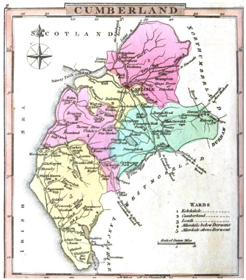
Dunmail is a legendary king of Cumberland associated with Dunmail Raise. According to tradition, Dunmail was the last king of Cumberland, and buried beneath the cairn at Dunmail Raise after having been slain by the English. Dunmail Raise, meaning "Dyfnwal's Cairn", may well be named after the historical Dyfnwal ab Owain, King of Strathclyde. Legend According to local legend, Dunmail, king of Cumberland, was attacked by the combined forces of Edmund I, Edmund and Malcolm I of Scotland, Malcolm and retreated into the heart of the Lake District. Dunmail met the kings in battle in the pass that divides Grasmere (lake), Grasmere from Thirlmere but was defeated, was killed in the fight (it is said at the hands of Edmund himself) and his sons were subsequently blinded by the victors. Some of the surviving Cumbrians, taken prisoner by Edmund, were ordered to collect rocks to pile on Dunmail's body, forming a cairn that still exists to this day and gives the pass its modern name, Dunmai ... [...More Info...] [...Related Items...] OR: [Wikipedia] [Google] [Baidu] |
Wigton
Wigton is a market town in the Allerdale borough of Cumbria, England. Historically in Cumberland, it lies just outside the Lake District in the borough of Allerdale. Wigton is at the centre of the Solway Plain, between the Caldbeck Fells and the Solway coast. It is served by Wigton railway station on the Cumbrian Coast Line, and the A596 road to Workington. The town of Silloth-on-Solway lies to the west, beyond Abbeytown. Etymology Wigton is "Wicga's tūn". "Wicga" is an Old English pre-7th-century personal name meaning "a beetle" (as in "earwig"), while "tūn" is Old English for a demarcated plot, a "homestead" or "village", so Wigton is "the hamlet belonging to Wicga". History On the River Wampool and Wiza Beck ( beck being a dialect word meaning "brook" or "stream" – from the Old Norse ''bekkr''), the market town of Wigton is an ancient settlement and evolved from a pre-medieval street plan, which can still be traced today. The Romans had a cavalry station, Maglo ... [...More Info...] [...Related Items...] OR: [Wikipedia] [Google] [Baidu] |
1988 Establishments In England
File:1988 Events Collage.png, From left, clockwise: The oil platform Piper Alpha explodes and collapses in the North Sea, killing 165 workers; The USS Vincennes (CG-49) mistakenly shoots down Iran Air Flight 655; Australia celebrates its Bicentennial on January 26; The 1988 Summer Olympics are held in Seoul, South Korea; Soviet troops begin their withdrawal from Afghanistan, which is completed the next year; The 1988 Armenian earthquake kills between 25,000-50,000 people; The 8888 Uprising in Myanmar, led by students, protests the Burma Socialist Programme Party; A bomb explodes on Pan Am Flight 103, causing the plane to crash down on the town of Lockerbie, Scotland- the event kills 270 people., 300x300px, thumb rect 0 0 200 200 Piper Alpha rect 200 0 400 200 Iran Air Flight 655 rect 400 0 600 200 Australian Bicentenary rect 0 200 300 400 Pan Am Flight 103 rect 300 200 600 400 1988 Summer Olympics rect 0 400 200 600 8888 Uprising rect 200 400 400 600 1988 Armenian earthquake r ... [...More Info...] [...Related Items...] OR: [Wikipedia] [Google] [Baidu] |
Workington Railway Station
Workington is a railway station on the Cumbrian Coast Line, which runs between and . The station, situated south-west of Carlisle, serves the town of Workington in Cumbria. It is owned by Network Rail and managed by Northern Trains. History The first Workington station on the Cumbrian Coast Line was built in the area known as Priestgate Marsh for the Whitehaven Junction Railway. Although the WJR was opened from Maryport to Workington in 1845 the WJR was advertising for tenders for building the station at Workington in October 1846. The WJR station had a single arrival and departure platform (the line was single until 1860) and no platform canopy "the platform is open to the prevailing winds, and " (we) " believe Workington is the only first-class station in Great Britain so unprovided with shelter" complained the Workington town trustees in 1858. In 1854 mis-set points led to a Maryport-Whitehaven goods train being routed into the end bay used by the Workington - Cockermout ... [...More Info...] [...Related Items...] OR: [Wikipedia] [Google] [Baidu] |
Maryport Railway Station
Maryport is a railway station on the Cumbrian Coast Line, which runs between and . The station, situated south-west of Carlisle, serves the town of Maryport in Cumbria. It is owned by Network Rail and managed by Northern Trains. It is unstaffed and passengers must buy their ticket on the train or at an automatic ticket machine outside the platform. Step-free access to the platform is available; train running information is provided by digital information screens and timetable posters. A new "eco-friendly" waiting shelter was erected at the station in the autumn 2011 (at a cost of £120,000) to replace the more basic facilities previously offered. The station is somewhat unusual in that it consists of a single bi-directional platform rather than the usual two side platforms used elsewhere on the double-track sections of the Cumbrian Coast line. Southbound trains have to cross over to the northbound line to reach the platform before returning to the correct line south o ... [...More Info...] [...Related Items...] OR: [Wikipedia] [Google] [Baidu] |
Workington North Railway Station
Workington North railway station was a temporary railway station in Cumbria, United Kingdom, constructed following floods which cut all road access to Workington town centre from north of the River Derwent. The station was located north of Workington station on the Cumbrian Coast Line. Until the new station opened, the closest station north of the River Derwent was Flimby railway station, which saw its passenger numbers increase enormously after the floods. Flimby had seen as many passengers on 24 November 2009 as would usually use the station in a fortnight. When the station first opened access to Workington by road from Northside involved a journey of because the bridges over the River Derwent for the A596 and A597 roads were destroyed or badly damaged by the flood. The construction of a temporary road bridge over the Derwent made vehicular access easier but the railway station remained open until 8 October 2010, when the last train called. Construction Network R ... [...More Info...] [...Related Items...] OR: [Wikipedia] [Google] [Baidu] |
2009 Cumbria And Southwest Scotland Floods
The 2009 Great Britain and Ireland floods were a weather event that affected parts of Great Britain and Ireland throughout November and into December 2009. November was the wettest month across the United Kingdom since records began in 1914 and had well above average temperatures. The worst affected area in Great Britain was the English county of Cumbria. The Irish counties of Clare, Cork, Galway and Westmeath were among the worst affected areas of Ireland. European windstorms bringing heavy rain and gale-force winds caused damage and flooding to the south of Great Britain on 13–14 November. Unsettled weather continued across the south and later to the north. On 19–20 November, many towns and villages in Cumbria and Dumfries and Galloway were affected. A number of bridges collapsed, one of which led to the death of a police officer, who was standing on the bridge when it collapsed. Another death occurred on 21 November as a canoeist was trapped against a tree near Poundsg ... [...More Info...] [...Related Items...] OR: [Wikipedia] [Google] [Baidu] |
Silloth-on-Solway
Silloth (sometimes known as Silloth-on-Solway) is a port town and civil parish in the Allerdale borough of Cumbria, England. Historically in the county of Cumberland, the town is an example of a Victorian seaside resort in the North of England. Silloth had a population of 2,932 at the 2001 Census, falling slightly to 2,906 at the 2011 Census. Location It sits on the shoreline of the Solway Firth, north of Workington and west of Carlisle. The town of Maryport lies south, down the B5300 coast road which also passes through the villages of Blitterlees, Beckfoot, Mawbray, and Allonby. Wigton is east, along the B5302 road, which also passes through the village of Abbeytown, southeast. History Silloth developed in the 1860s onwards around the terminus of the railway from Carlisle and associated docks which had begun construction in 1855 to replace Port Carlisle as the deep-water port for Carlisle. Workers from the factories of Carlisle were presented with access ... [...More Info...] [...Related Items...] OR: [Wikipedia] [Google] [Baidu] |
Blitterlees
Blitterlees is a small hamlet in the parish of Holme Low, one mile south of Silloth in Cumbria, United Kingdom. The hamlet of Wolsty is located approximately to the south as the crow flies, or by road, and Cumbria's county town, Carlisle, is located to the east. The B5300, known locally as the "coast road", runs through the village on its way to Beckfoot, Mawbray, Allonby, and ultimately Maryport. History and etymology The name "Blitterlees" comes from the Old English ''blaecфorn-læs'', meaning a blackthorn pasture. Previous variant spellings include Bletterliese, Bletherleese, and Bladderlies. During the Roman period, the coast around present-day Blitterlees was fortified, as a series of milefortlets were built along the Solway plain, extending beyond the western end of Hadrian's Wall. The closest milefortlet to the settlement was milefortlet 12, which was originally constructed of earth and timber. In the 19th century, the name was spelled Blitter Lees, with a space betw ... [...More Info...] [...Related Items...] OR: [Wikipedia] [Google] [Baidu] |
Beckfoot
Beckfoot is a hamlet in the civil parish of Holme St Cuthbert in Cumbria, England. It is located on the B5300 coast road, three miles south of Silloth-on-Solway and two miles north of the village of Mawbray. The county town of Carlisle is twenty-five miles away to the east. History and etymology The name "Beckfoot" is derived from the Old Norse ''bekkr-futr'', meaning "the mouth of a stream". Beck is a local word in Cumbrian dialect for a stream. Such a beck empties into the Solway Firth at the southern end of the hamlet, and it is this watercourse which gives the settlement its name. There are two known recorded variant spellings: Beck and Beckfoote. The area around Beckfoot was fortified during Roman times, as a series of milefortlets were constructed to guard the coast beyond the western end of Hadrian's Wall. The remains of milefortlets 14 and 15 are located nearby. In 2010 a broken pottery vessel containing 308 Roman coins was discovered by a local archaeologist using ... [...More Info...] [...Related Items...] OR: [Wikipedia] [Google] [Baidu] |
Mawbray
Mawbray is a village in the civil parish of Holme St Cuthbert in the Allerdale borough of Cumbria, England. Historically part of Cumberland. It is located on the Solway Plain, south west of Silloth, north of Maryport, and west of Carlisle. The B5300, known locally as the "coast road" runs to the west of the village. Mawbray serves as the hub of a community of several smaller hamlets, including Beckfoot, Goodyhills, Hailforth, Holme St Cuthbert, Jericho, Newtown, Salta, and Tarns. Etymology The name "Mawbray" is believed to be derived from Latin, meaning "a maiden's castle or fort". This would be consistent with Roman mile-forts known to exist nearby on the coast, especially in the Maryport area. A Roman fortlet, known as Milefortlet 16, has been located at the west end of the village.MILEFORTLET 16 Pastscape, retrieved 26 N ... [...More Info...] [...Related Items...] OR: [Wikipedia] [Google] [Baidu] |
Dubmill
Dubmill is a settlement in the civil parish of Holme St. Cuthbert in Cumbria, United Kingdom. It is located approximately one mile south-west of the village of Mawbray, half-a-mile to the west of the hamlet of Salta, three-quarters of a mile south-west of the hamlet of Hailforth, and one-and-a-half miles north of the village of Allonby. Carlisle, Cumbria's county town, lies approximately twenty-eight miles to the north-east. The B5300, known locally as the coast road, runs through Dubmill. Dubmill lends its name to both Dubmill Point and Dubmill Scar. Dubmill Point is the name for the headland at the northernmost tip of Allonby Bay, and Dubmill Scar is the name for the rocky beach off Dubmill Point. History and etymology The name of Dubmill comes from the Old English ''dub-myln'' meaning "a mill at the pool". Historical variant spellings include Dubmil, Dubmilne, Dubhime, Dub-horn, and Dubbmill. A beck called the Black Dub runs near to Dubmill, and may be related to the na ... [...More Info...] [...Related Items...] OR: [Wikipedia] [Google] [Baidu] |


