|
Dunajec River
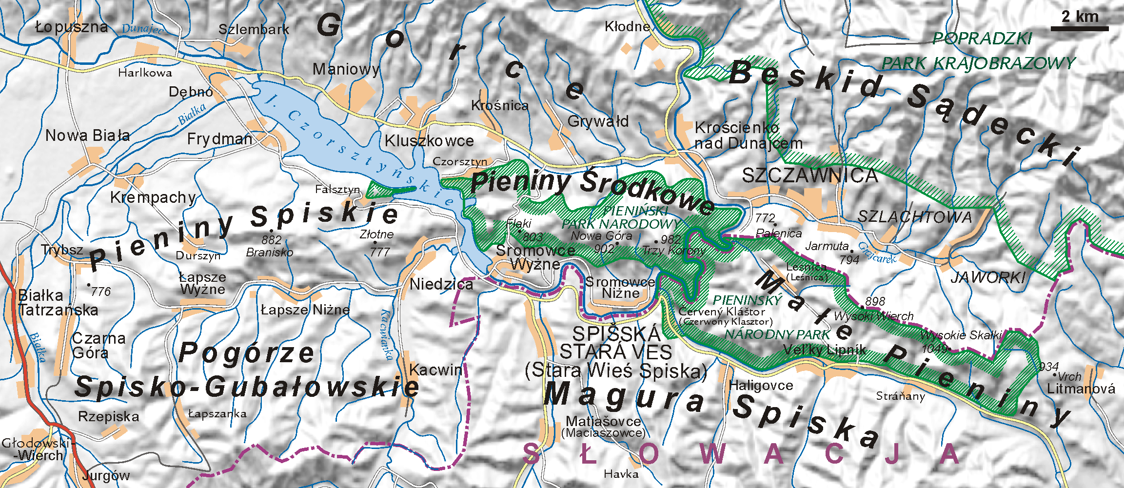
The Dunajec (); Goral dialects: ''Dónajec'') is a river running through northeastern Slovakia and southern Poland. It is also regarded as the main river of the Goral Lands. It is a right tributary of the Vistula River. It begins in Nowy Targ at the junction of two short mountain rivers, Czarny Dunajec and Biały Dunajec (Black and White Dunajec). Dunajec forms the border between Poland and Slovakia for in the Pieniny Środkowe (Slovak: Centrálne Pieniny) range, east of the Czorsztyn reservoir. Geography The Dunajec is long, including its source river Czarny Dunajec,Statistical Yearbook of the Republic of Poland 2017 |
Trzy Korony
Trzy Korony ( en, Three Crowns, sk, Tri Koruny) is the summit of the Three Crowns Massif, an independent portion of a range called Pieniny Mountains in the south of Poland. Trzy Korony forms the central part of a compact group of connected mountains known as Pieniny Środkowe, consisting mainly of the limestone and dolomite rock strata. Trzy Korony is located within the Pieniny National Park in Lesser Poland Voivodeship. 8.69 MB Geography The summit is separated from the surrounding peaks (known as Łysiny Group) by the Wyżni Łazek Pass, descending into deep valleys with streams surrounded by forested slopes. The Three Crowns consists of five sharp peaks, made of resistant limestone. The highest of the peaks is called Okrąglica. It stands 982 meters above sea level. At the top of Okrąglica there is an observation platform complete with metal barriers built for the tourists. – The platform, overlooking Dunajec River Gorge, can accommodate up to 15 people at a ... [...More Info...] [...Related Items...] OR: [Wikipedia] [Google] [Baidu] |
Červený Kláštor
Červený Kláštor () is a small village and municipality in the far north Kežmarok District in the Prešov Region of northern Slovakia, near the Polish border, in the Zamagurie region. History A Camaldolese monastery was established on this location, then part of the Habsburg-ruled Kingdom of Hungary, in 1710. In 1782, it was secularized as part of Emperor Joseph II's campaign against monastic orders that, in his view, didn't pursue useful activities. The monastery building still exists however (see photo). The present village was founded in 1828. Geography The municipality lies at an altitude of 465 metres and covers an area of 3.043 km2. It has a population of about 222 people. It lies 8 km east of the centre of Zamagurie region, Spišská Stará Ves. The governing body of the Pieniny national park is located in the village. Dunajec river, which makes border with Poland, flows near the village. It is used for tourist purposes for rafting. Other attractions in o ... [...More Info...] [...Related Items...] OR: [Wikipedia] [Google] [Baidu] |
Majere (village)
Places * Majere (village) is a village in Slovakia. Fiction Majere, in the fictional world of Dragonlance, may refer to: * Raistlin Majere * Caramon Majere * Tika Waylan, also known as Tika Waylan Majere * Palin Majere * Tanin Majere * Ulin Majere * Sturm Majere * Usha Majere * Linsha Majere * Dezra Majere This is a list of characters in the ''Dragonlance'' series of fantasy novels and related fantasy role-playing game materials. It includes accounts of their early lives in the series. Characters Alhana Starbreeze Alhana Starbreeze, Silvanesti El ... * Laura Majere {{disambig ... [...More Info...] [...Related Items...] OR: [Wikipedia] [Google] [Baidu] |
Spišská Stará Ves
Spišská Stará Ves (german: Alt(en)dorf; hu, Szepesófalu or hu, Ófalu; pl, (Stara) Spiska Wieś; la, Antiqua Villa; Goral: Golembarg) is a small town and urban municipality in Kežmarok District in the Prešov Region of north Slovakia. Prior to World War I, the town was part of Szepes county in the Kingdom of Hungary. History In historical records the town was first mentioned in 1272. Geography The town and municipality lies at an altitude of 505 metres and covers an area of . It has a population of about 2,200 people. Spišská Stará Ves is the centre of Zamagurie region and is close to the Dunajec River. Demographics According to the 2001 census, the town had 2,355 inhabitants. 93.76% of inhabitants were Slovaks, 4.50% Roma, 0.53% Polish, 0.30% Czechs and 0.25% Ukrainians. The religious makeup was 93.25% Roman Catholics, 2.93% Greek Catholics, 1.66% people with no religious affiliation and 0.85% Lutherans Lutheranism is one of the largest branches of Protestantis ... [...More Info...] [...Related Items...] OR: [Wikipedia] [Google] [Baidu] |
Opatowiec
Opatowiec is a small town in Kazimierza County, Świętokrzyskie Voivodeship, in south-central Poland. It is the seat of the gmina (administrative district) called Gmina Opatowiec. It lies in Lesser Poland, on the left bank of the River Vistula (opposite the confluence of the Dunajec), approximately east of Kazimierza Wielka and south of the regional capital Kielce. It regained its urban status on 1 January 2019, becoming the smallest town in Poland, with only 338 inhabitants. Opatowiec is situated on the National Road Nr. 79 (Warsaw–Bytom). Local points of interest include a 15th-century Dominican church and a central park. History The village of Opatowiec was first mentioned in 1085, when Judyta, the wife of Prince Władysław I Herman, presented it to the Benedictine monks from Tyniec. In 1271, Prince Boleslaw V the Chaste granted Opatowiec a town charter under Magdeburg rights, upon the request of abbot Modlibob. The town became a local trade center, due to its location ... [...More Info...] [...Related Items...] OR: [Wikipedia] [Google] [Baidu] |
Vistula River
The Vistula (; pl, Wisła, ) is the longest river in Poland and the ninth-longest river in Europe, at in length. The drainage basin, reaching into three other nations, covers , of which is in Poland. The Vistula rises at Barania Góra in the south of Poland, above sea level in the Silesian Beskids (western part of Carpathian Mountains), where it begins with the Little White Vistula (''Biała Wisełka'') and the Black Little Vistula (''Czarna Wisełka''). It flows through Poland's largest cities, including Kraków, Sandomierz, Warsaw, Płock, Włocławek, Toruń, Bydgoszcz, Świecie, Grudziądz, Tczew and Gdańsk. It empties into the Vistula Lagoon (''Zalew Wiślany'') or directly into the Gdańsk Bay of the Baltic Sea with a delta of six main branches (Leniwka, Przekop, Śmiała Wisła, Martwa Wisła, Nogat and Szkarpawa). The river is often associated with Polish culture, history and national identity. It is the country's most important waterway and natural symbol, an ... [...More Info...] [...Related Items...] OR: [Wikipedia] [Google] [Baidu] |
Sandomierz
Sandomierz (pronounced: ; la, Sandomiria) is a historic town in south-eastern Poland with 23,863 inhabitants (as of 2017), situated on the Vistula River in the Sandomierz Basin. It has been part of Świętokrzyskie Voivodeship (Holy Cross Province) since 1999, having previously been located in the Tarnobrzeg Voivodeship. It is the capital of Sandomierz County. Sandomierz is known for its preserved Old Town, a major cultural and tourist attraction which was declared a National Monument of Poland in 2017. In the past, Sandomierz used to be one of the most important urban centers not only of Lesser Poland, but also of the whole country. It was a royal city of the Polish Crown and a regional administrative centre from the High Middle Ages to the 19th century. Etymology The name of the city might have originated from the Old Polish ', composed of ' (from the verb ' "to judge") and ' ("peace"), or more likely from the antiquated given name Sędzimir, once popular in several Slavi ... [...More Info...] [...Related Items...] OR: [Wikipedia] [Google] [Baidu] |
Rożnów, Lesser Poland Voivodeship
Rożnów is a village in the administrative district of Gmina Gródek nad Dunajcem, within Nowy Sącz County, Lesser Poland Voivodeship, in southern Poland. It lies approximately north of Nowy Sącz and south-east of the regional capital Kraków. The village has a population of 1,700. Rożnów Dam Rożnów is the location of a dam on the Dunajec and a power station built in 1935-1941. The dam was constructed originally to prevent flooding after the disastrous 1934 flood in Poland which took the lives of 55 people and caused damages estimated at 60 million interbellum zlotys; the biggest flood in the Second Polish Republic. The construction of the Rożnów Dam resulted in the creation of the |
Beskids
The Beskids or Beskid Mountains ( pl, Beskidy, cs, Beskydy, sk, Beskydy, rue, Бескиды (''Beskydŷ''), ua, Бескиди (''Beskydy'')) are a series of mountain ranges in the Carpathians, stretching from the Czech Republic in the west along the border of Poland with Slovakia up to Ukraine in the east. The highest mountain in the Beskids is Hoverla, at 2,061 m metres (6,762 ft). Etymology The origin of the name ''beskydy'' has not been conclusively established. A Thracian or Illyrian origin has been suggested, however, as yet, no theory has majority support among linguists. The word appears in numerous mountain names throughout the Carpathians and the adjacent Balkan regions, like in Albanian ''bjeshkë''. According to linguists Çabej and Orel, it is possibly derived from Proto-Albanian "''*beškāi tāi''" (meaning the mountain pastures).The Slovak name ''Beskydy'' refers to the Polish Bieszczady Mountains, which is not a synonym for the entire Beskids but o ... [...More Info...] [...Related Items...] OR: [Wikipedia] [Google] [Baidu] |
Kotuńka
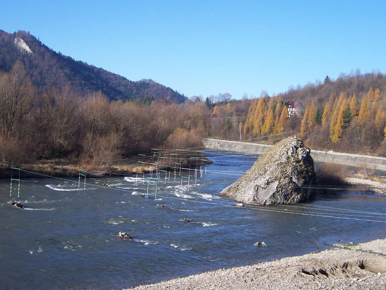
The Kotuńka Rock is a prominent rock found in the centre of the current of the river Dunajec just before the entry into Szczawnica. Built from limestone, the rock is well seen from the road and is a characteristic landmark in the area. Just above the rock the Grajcarek flows into the Dunajec. On from the rock is a bridge, after which begins the Pieniny Trail Road which heads to a border crossing. Around the Kotuńka rock the Dunajec river rapid is very strong and creates a swirl. This water feature is used by mountain kayakers, which often train in the area, to the left of the Kotuńka rock are embedded gates for such activities. As with many Pieniny rocks, the Kotuńka rock also has a legend. According to the legend, the devil carried a rock which he tried to bring to the Pieniny Castle on the Castle Mountain in the Pieniny, before which in the Tatra Mountains Kinga of Poland was hiding in. However along the way a rooster crowed and the devil's energy went away. The rock fell from ... [...More Info...] [...Related Items...] OR: [Wikipedia] [Google] [Baidu] |
Szczawnica
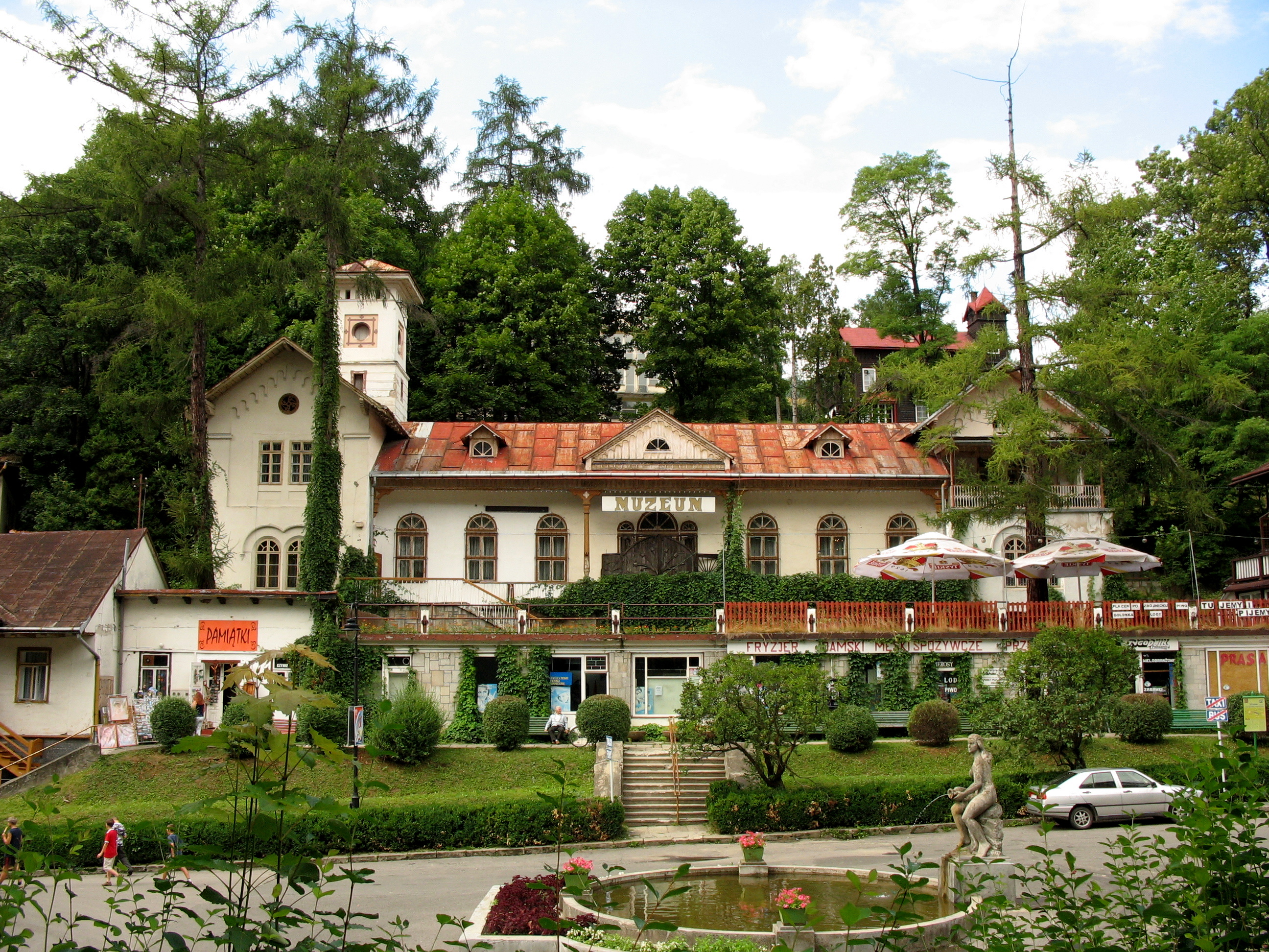
Szczawnica is a resort town in Nowy Targ County in Lesser Poland Voivodeship, in southern Poland. As of June 30, 2007, its population was 7,378. Szczawnica has been a well-known resort town since the mid nineteenth century. Due to the presence of alkali sorrel springs and favorable climatic conditions, many respiratory and digestive tract illnesses are treated there. In 2005 the popular local spa was officially returned by the Polish government to its prewar owners – Count Stadnicki family. The spa has almost two-hundred-year history. Its last private owner was Count Adam Stadnicki, whose grandson – Andrzej Mańkowski – is the founder of the new Spa Town Museum being fitted in the center of Szczawnica, at Dietl Square (2009). The museum of the Szczawnica resort aims to present more than 350 different types of artifacts associated with the local therapeutics, archival documents, drawings, plans of buildings, old photographs, postcards and books. Szczawnica has many skiing t ... [...More Info...] [...Related Items...] OR: [Wikipedia] [Google] [Baidu] |


