|
Dulverton Railway Station
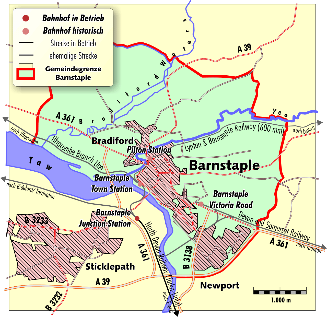
The Devon and Somerset Railway (D&SR) was a cross-country line that connected Barnstaple in Devon, England, to the network of the Bristol and Exeter Railway (B&ER) near Taunton. It was opened in stages between 1871 and 1873 and closed in 1966. It served a mostly rural area although it carried some through services from east of Taunton to the seaside resort of Ilfracombe. From 1988 onwards the route of the line west of South Molton was redeveloped to form the part of the North Devon Link Road. History The Act of Parliament that authorised the D&SR received assent on 29 July 1864. Eugenius Birch was appointed as Engineer, but he was replaced by Richard Hassard in 1870. The first section of the line was opened on 8 June 1871, from Watchet Junction (later Norton Fitzwarren) to on the edge of Exmoor. The remaining to Barnstaple opened on 1 November 1873. The line used its own station at Barnstaple (later to be named Victoria Road), some distance from the rival station at Barns ... [...More Info...] [...Related Items...] OR: [Wikipedia] [Google] [Baidu] |
Bristol And Exeter Railway
The Bristol & Exeter Railway (B&ER) was an English railway company formed to connect Bristol and Exeter. It was built on the broad gauge and its engineer was Isambard Kingdom Brunel. It opened in stages between 1841 and 1844. It was allied with the Great Western Railway (GWR), which built its main line between London and Bristol, and in time formed part of a through route between London and Cornwall. It became involved in the gauge wars, a protracted and expensive attempt to secure territory against rival companies supported by the London and South Western Railway (LSWR) which used the narrow gauge, later referred to as ''standard gauge''. At first it contracted with the GWR for that company to work the line, avoiding the expense of acquiring locomotives, but after that arrangement expired in 1849, the B&ER operated its own line. It opened a number of branches within the general area it served: to Clevedon, Cheddar, Wells, Weston-super-Mare, Chard, Yeovil and Tiverton. The B ... [...More Info...] [...Related Items...] OR: [Wikipedia] [Google] [Baidu] |
Nationalisation
Nationalization (nationalisation in British English) is the process of transforming privately-owned assets into public assets by bringing them under the public ownership of a national government or state. Nationalization usually refers to private assets or to assets owned by lower levels of government (such as municipalities) being transferred to the state. Nationalization contrasts with privatization and with demutualization. When previously nationalized assets are privatized and subsequently returned to public ownership at a later stage, they are said to have undergone renationalization. Industries often subject to nationalization include the commanding heights of the economy – telecommunications, electric power, fossil fuels, railways, airlines, iron ore, media, postal services, banks, and water – though, in many jurisdictions, many such entities have no history of private ownership. Nationalization may occur with or without financial compensation to the former owners. ... [...More Info...] [...Related Items...] OR: [Wikipedia] [Google] [Baidu] |
Wiveliscombe
Wiveliscombe (, ) is a small town and civil parish in Somerset, England, situated west of Taunton in the Somerset West and Taunton district. The town has a population of 2,893. The Square, fronted by several listed structures, held the former market. The parish includes the nearby hamlet of Maundown. History Settlement in the neighbourhood is of long standing. The Neolithic hillfort at King's Castle is east of the town. North west of the town is Clatworthy Camp, an Iron Age hillfort. Nearby is Elworthy Barrows, an unfinished Iron Age hillfort, rather than Bronze Age barrows. A rectangular enclosure south of Manor Farm is the remains of a Roman fort; in the 18th century, vestiges of its fortifications and foundations were identified as being of Roman origin, and it was locally called "the Castle". In the 18th century a hoard of about 1600 Roman coins of third and fourth century dates was uncovered. The Anglo-Saxon settlement, the ''combe'' or valley of a certain Wifele, was m ... [...More Info...] [...Related Items...] OR: [Wikipedia] [Google] [Baidu] |
Signal Box
In signal processing, a signal is a function that conveys information about a phenomenon. Any quantity that can vary over space or time can be used as a signal to share messages between observers. The ''IEEE Transactions on Signal Processing'' includes audio, video, speech, image, sonar, and radar as examples of signal. A signal may also be defined as observable change in a quantity over space or time (a time series), even if it does not carry information. In nature, signals can be actions done by an organism to alert other organisms, ranging from the release of plant chemicals to warn nearby plants of a predator, to sounds or motions made by animals to alert other animals of food. Signaling occurs in all organisms even at cellular levels, with cell signaling. Signaling theory, in evolutionary biology, proposes that a substantial driver for evolution is the ability of animals to communicate with each other by developing ways of signaling. In human engineering, signals are typi ... [...More Info...] [...Related Items...] OR: [Wikipedia] [Google] [Baidu] |
Milverton, Somerset
Milverton is a village and civil parish in Somerset, England, situated in the valley of the River Tone west of Taunton in the Somerset West and Taunton district. The village has a population of 1,438. The parish includes the hamlet of Preston Bowyer. It has one public house, ''The Globe'' (The ''White Hart'' public house closed in March 2008), a convenience store, a piano dealership and workshop, a post office, a taxi service and a hairdresser. History The name of the village is believed to come from the Old English and mean ''settlement at the mill ford''. There is evidence of a mill within the parish from the Domesday Book of 1086. These referred to the site of the Town Mills on Hillfarrence Brook. Neolithic flint arrowheads have been found to the west of the village and Bronze Age axe heads were discovered when the bypass, which opened in 1975, was being built. Just before the Norman Conquest, Milverton was granted by Queen Edith to Bishop Giso of Wells, but this was rev ... [...More Info...] [...Related Items...] OR: [Wikipedia] [Google] [Baidu] |
West Somerset Railway
The West Somerset Railway (WSR) is a heritage railway line in Somerset, England. The freehold of the line and stations is owned by Somerset County Council; the railway is leased to and operated by West Somerset Railway plc (WSR plc); which is supported and minority-owned by charitable trust the West Somerset Railway Association (WSRA) and the West Somerset Steam Railway Trust (WSSRT). The WSR plc operates services using both heritage steam and diesel trains. It originally opened in 1862 between and . In 1874 it was extended from Watchet to by the Minehead Railway. Although just a single line, improvements were needed in the first half of the twentieth century to accommodate the significant number of tourists that wished to travel to the Somerset coast. The line was closed by British Rail in 1971 and reopened in 1976 as a heritage line. It is the longest standard gauge independent heritage railway in the United Kingdom. Services normally operate over just the between Mine ... [...More Info...] [...Related Items...] OR: [Wikipedia] [Google] [Baidu] |
Norton Fitzwarren
Norton Fitzwarren is a village, electoral ward, and civil parish in Somerset, England, situated north west of Taunton in the Somerset West and Taunton district. The village has a population of 3,046. History The village is on the southern slope of Norton Camp, a large hillfort that shows evidence of occupation from neolithic times, through the Bronze Age, to the Roman occupation of Britain. The Church of All Saints dates from the late 13th and early 14th century. It has been designated as a Grade II* listed building. The parish of Norton Fitzwarren was part of the Taunton Deane Hundred. On 23 November, 2021 a double murder occurred in the village, involving a local IT teacher and coffee shop worker. Governance The parish council has responsibility for local issues, including setting an annual precept (local rate) to cover the council’s operating costs and producing annual accounts for public scrutiny. The parish council evaluates local planning applications and works with ... [...More Info...] [...Related Items...] OR: [Wikipedia] [Google] [Baidu] |
Ordnance Survey
, nativename_a = , nativename_r = , logo = Ordnance Survey 2015 Logo.svg , logo_width = 240px , logo_caption = , seal = , seal_width = , seal_caption = , picture = , picture_width = , picture_caption = , formed = , preceding1 = , dissolved = , superseding = , jurisdiction = Great BritainThe Ordnance Survey deals only with maps of Great Britain, and, to an extent, the Isle of Man, but not Northern Ireland, which has its own, separate government agency, the Ordnance Survey of Northern Ireland. , headquarters = Southampton, England, UK , region_code = GB , coordinates = , employees = 1,244 , budget = , minister1_name = , minister1_pfo = , chief1_name = Steve Blair , chief1_position = CEO , agency_type = , parent_agency = , child1_agency = , keydocument1 = , website = , footnotes = , map = , map_width = , map_caption = Ordnance Survey (OS) is the national mapping agency for Great Britain. The agency's name indicates its original military purpose (se ... [...More Info...] [...Related Items...] OR: [Wikipedia] [Google] [Baidu] |
Viaduct
A viaduct is a specific type of bridge that consists of a series of arches, piers or columns supporting a long elevated railway or road. Typically a viaduct connects two points of roughly equal elevation, allowing direct overpass across a wide valley, road, river, or other low-lying terrain features and obstacles. The term ''viaduct'' is derived from the Latin ''via'' meaning "road", and ''ducere'' meaning "to lead". It is a 19th-century derivation from an analogy with ancient Roman aqueducts. Like the Roman aqueducts, many early viaducts comprised a series of arches of roughly equal length. Over land The longest in antiquity may have been the Pont Serme which crossed wide marshes in southern France. At its longest point, it measured 2,679 meters with a width of 22 meters. Viaducts are commonly used in many cities that are railroad hubs, such as Chicago, Birmingham, London and Manchester. These viaducts cross the large railroad yards that are needed for freight trains there, ... [...More Info...] [...Related Items...] OR: [Wikipedia] [Google] [Baidu] |
Filleigh
Filleigh is a small village, civil parish and former manor in North Devon, on the southern edge of Exmoor, west of South Molton. The village centre's street was, until the 1980s opening of the North Devon Link Road, the main highway between the North Devon administrative centre of Barnstaple and South Molton, leading westwards to Taunton. Much of the village's land is contained within grade I listed park and garden, Castle Hill, which straddles both sides of the Link Road providing a glimpse of some of it. History Manor De Filleigh The manor was held in the 14th century by a family which took its name from the manor, de Filleigh. The family also held lands within the neighbouring settlements of East Buckland, Bray and Charles. Denzell On default of male heirs, the manor passed by marriage to the Denzell (or Densyll etc.) family. This family originated from Denzell manor in St Mawgan parish, near St Columb Major, near Newquay, Cornwall. The senior line became extinct in ... [...More Info...] [...Related Items...] OR: [Wikipedia] [Google] [Baidu] |
Castle Hill, Filleigh
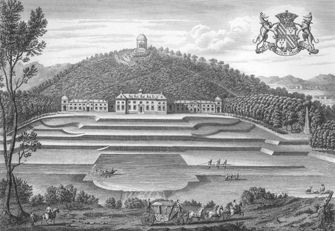
Castle Hill in the parish of Filleigh in North Devon, is an early Neo-Palladian country house situated north-west of South Molton and south-east of Barnstaple. It was built in 1730 by Hugh Fortescue, 14th Baron Clinton (1696–1751), who was later created in 1751 1st Baron Fortescue and 1st Earl of Clinton, the son of Hugh Fortescue (died 1719), lord of the manor of Filleigh, Weare Giffard, etc., whose family is earliest recorded as residing in the 12th century at the manor of Whympston in the parish of Modbury in South Devon. The Fortescue family became major land owners, influential in British and West Country history. Castle Hill is a rare example in Devon of an 18th-century country mansion "on the grand scale". The house was substantially reconstructed following a disastrous fire in 1934. It was designated a Grade II* listed building in 1967. The park and gardens are Grade I listed in the National Register of Historic Parks and Gardens. Today the property is leased ... [...More Info...] [...Related Items...] OR: [Wikipedia] [Google] [Baidu] |
Wrought Iron
Wrought iron is an iron alloy with a very low carbon content (less than 0.08%) in contrast to that of cast iron (2.1% to 4%). It is a semi-fused mass of iron with fibrous slag Inclusion (mineral), inclusions (up to 2% by weight), which give it a wood-like "grain" that is visible when it is etched, rusted, or bent to structural failure, failure. Wrought iron is tough, malleable, ductile, corrosion resistant, and easily forge welding, forge welded, but is more difficult to welding, weld electrically. Before the development of effective methods of steelmaking and the availability of large quantities of steel, wrought iron was the most common form of malleable iron. It was given the name ''wrought'' because it was hammered, rolled, or otherwise worked while hot enough to expel molten slag. The modern functional equivalent of wrought iron is Carbon steel#Mild or low-carbon steel, mild steel, also called low-carbon steel. Neither wrought iron nor mild steel contain enough carbon to be ... [...More Info...] [...Related Items...] OR: [Wikipedia] [Google] [Baidu] |


