|
Dreieck Havelland
The Dreieck Havelland (German: ''Autobahndreieck Havelland'', abbreviated ''AD Havelland'') is a trumpet interchange in the German state of Brandenburg in the metropolitan region of Berlin. The interchange connects the A24 coming from Hamburg to the A10, the Berlin-beltway. Geography The interchange lies in the region of Havelland after which it is named, in the municipal area of Oberkrämer and Kremmen in the Landkreis Oberhavel Oberhavel is a ''Kreis'' (district) in the northern part of Brandenburg, Germany. Its neighbouring districts are (clockwise from the north): Mecklenburg-Strelitz in Mecklenburg-Western Pomerania, the districts of Uckermark and Barnim, the ''Bundesl .... The nearby towns are Schönwalde-Glien und Nauen. It lies approximately 30 km northwest of the Berlin city centre. History Dreieck Havelland was built as a trumpet interchange between 1972 and 1979, as they were extending the Berlin-beltway. In July 2011, the plans were made to wid ... [...More Info...] [...Related Items...] OR: [Wikipedia] [Google] [Baidu] |
Oberkrämer
Oberkrämer is a municipality in the Oberhavel district, in Brandenburg, Germany. An experimental farm of wind turbines existed between 1941 and 1945 on the 50 m high Matthias mountain in the area. Subdivisions Oberkrämer consists of formerly separate municipalities, which as of 31 December 2001 merged with the new municipality of Oberkrämer. On 27 September 1998, the municipalities of Eichstädt, Neu-Vehlefanz and Vehlefanz merged into the new municipality of Oberkrämer. On 31 December 2001, the municipalities of Bärenklau, Bötzow, Marwitz and Schwante were merged into the municipality of Oberkrämer. Demography File:Bevölkerungsentwicklung Oberkrämer.pdf, Development of population since 1875 within the current Boundaries (Blue Line: Population; Dotted Line: Comparison to Population development in Brandenburg state; Grey Background: Time of Nazi Germany; Red Background: Time of communist East Germany) File:Bevölkerungsprognosen Oberkrämer.pdf, Recent Popula ... [...More Info...] [...Related Items...] OR: [Wikipedia] [Google] [Baidu] |
Havelland
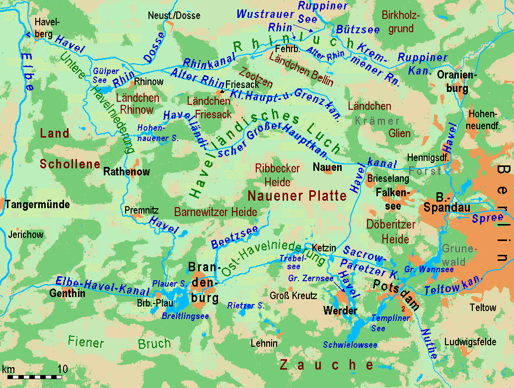
Geographically, the Havelland is the region around which the River Havel flows in a U-shape between Oranienburg to the northeast and Rhinow to the northwest. The northern boundary of the Havelland is formed by the River Rhin and the Rhin Canal. In the history of Brandenburg, the Havelland represents a historic region. In the heart of the Havelland is the county of the same name. In addition the Havelland includes the south of Ruppin Land with the Rhinluch, the western part of Berlin's Spandau, parts of Potsdam, the town of Brandenburg an der Havel and several villages in the county of Potsdam-Mittelmark. The Tourist Association of Havelland has chosen a rather different boundary. It covers the county of Havelland, the town of Brandenburg an der Havel and the northern part of the county of Potsdam-Mittelmark, including communities south of the Havel river, that belong to the region of Zauche. The writer Theodor Fontane described the Havelland as well as the other landscapes of ... [...More Info...] [...Related Items...] OR: [Wikipedia] [Google] [Baidu] |
Berliner Morgenpost
''Berliner Morgenpost'' is a German newspaper, based and mainly read in Berlin, where it is the second most read daily newspaper. History and profile Founded in 1898 by Leopold Ullstein, the paper was taken over by Axel Springer AG in 1959. It was sold to Funke Mediengruppe in 2013. The paper had a circulation of 145,556 issues in 2009, with an estimated 322,000 readers The current editor-in-chief is Carsten Erdmann. It was awarded the European Newspaper of the Year in the category of regional newspaper by the European Newspapers Congress in 2012. Editor-in-chiefs * 1952–1953 Wilhelm Schulze * 1953–1959 Helmut Meyer-Dietrich * 1960–1972 Heinz Köster * 1973–1976 Walter Brückmann * 1976–1978 Werner Marquardt * 1978–1981 Wolfgang Kryszohn * 1981–1987 Johannes Otto * 1988–1996 Bruno Waltert * 1996–1999 Peter Philipps * 1999–2002 Herbert Wessels * 2002 Wolfram Weimer Wolfram may refer to: * Wolfram (name) * Wolfram, an alternative name for the chemical ele ... [...More Info...] [...Related Items...] OR: [Wikipedia] [Google] [Baidu] |
Neuruppin
Neuruppin (; North Brandenburgisch: ''Reppin'') is a town in Brandenburg, Germany, the administrative seat of Ostprignitz-Ruppin district. It is the birthplace of the novelist Theodor Fontane (1819–1898) and therefore also referred to as ''Fontanestadt''. A garrison town since 1688 and largely rebuilt in a Neoclassical style after a devastating fire in 1787, Neuruppin has the reputation of being "the most Prussian of all Prussian towns". Geography Geographical position Neuruppin is one of the largest cities in Germany in terms of area. The city of Neuruppin, northwest of Berlin in the district of Ostprignitz-Ruppin (Ruppin Switzerland), consists in the south of the districts located on the shores of Ruppiner See, which is crossed by the Rhin River, including the actual core city of Neuruppin and Alt Ruppin. In the north, it stretches up to the Rheinsberg Lake Region and the border with Mecklenburg-Vorpommern. It is part of the Stechlin-Ruppiner Land Nature Park and is connected ... [...More Info...] [...Related Items...] OR: [Wikipedia] [Google] [Baidu] |
Nauen
Nauen is a small town in the Havelland district, in Brandenburg, Germany. It is chiefly known for Nauen Transmitter Station, the world's oldest preserved radio transmitting installation. Geography Nauen is situated within the Havelland Luch glacial lowland, the heart of the Havelland region north of the Nauen Plateau, about west of the Berlin's city center ( from the Berlin city limits) and northwest of Potsdam. It is one of Germany's largest municipalities by area, comprising Nauen proper and fourteen surrounding villages, including Ribbeck whose landowners were perpetuated in Theodor Fontane's poem ''Herr von Ribbeck auf Ribbeck im Havelland''. History The settlement of ''Nowen'' was first mentioned in an 1186 deed issued by the Bishop of Brandenburg. The citizens received town privileges by the Brandenburg margraves in 1292; a first town hall was built in 1302. The Ascanian margrave Waldemar vested Nauen with market rights in 1317. A Jewish community already existed in med ... [...More Info...] [...Related Items...] OR: [Wikipedia] [Google] [Baidu] |
Schönwalde-Glien
Schönwalde-Glien is a municipality in the Havelland district, in Brandenburg, Germany. History The municipality shared its borders with the former West Berlin, and so during the period 1961-1990 it was separated from it by the Berlin Wall. In 1951–2, the Havel Canal was constructed through the municipality to link Hennigsdorf with Paretz, thus avoiding a passage through the reach of the River Havel, between Spandau and Potsdam, that was under the political control of West Berlin. The single lock on the canal is located at Schönwalde. The canal is still in use, providing a shorter route for shipping from west of Berlin to the Oder–Havel Canal and Poland. Geography The municipality covers an area mainly north of the Havel Canal, north west of Spandau Forest (Berlin-Spandau) and about 10 km north east of Nauen. Only its most densely populated quarter, Schönwalde-Siedlung, is situated south of the Havel Canal and shares an immediate border with Berlin-Spandau. Schönwa ... [...More Info...] [...Related Items...] OR: [Wikipedia] [Google] [Baidu] |
Landkreis Oberhavel
Oberhavel is a ''Kreis'' (district) in the northern part of Brandenburg, Germany. Its neighbouring districts are (clockwise from the north): Mecklenburg-Strelitz in Mecklenburg-Western Pomerania, the districts of Uckermark and Barnim, the ''Bundesland'' of Berlin, and the districts of Havelland and Ostprignitz-Ruppin. Geography The district is located on the upper course of the Havel river from its source to the outskirts of Berlin. The north is characterised by many lakes including the Großer Stechlinsee, which is well known thanks to a novel by Theodor Fontane called ''Der Stechlin''. History The district was created on 6 December 1993 through the merging of the old Gransee and Oranienburg districts. Coat of arms The coat of arms shows the eagle as the symbol of Brandenburg in the upper part. In the lower half are two flying swans on green background representing nature with many lakes. The coat of arms was unofficially used by the precursor district of Oranienburg before the ... [...More Info...] [...Related Items...] OR: [Wikipedia] [Google] [Baidu] |
Bundesautobahn 10
is an orbital motorway around the German capital city of Berlin. Colloquially called ''Berliner Ring'', it is predominantly located in the state of Brandenburg, with a short stretch of in Berlin itself. It should not be confused with the ''Berliner Stadtring'' (Bundesautobahn 100) around Berlin's inner city. With a total length of , the BAB 10 is the longest orbital in Europe, being longer than the M25 motorway around London. Course The highway route markers run clockwise from the interchange at Schwanebeck (the former Prenzlau branch-off), where the Bundesautobahn 11 runs to Szczecin, Poland via the Pomellen/Kołbaskowo border crossing and the Polish A6 autostrada. From here the beltway leads southwards to the Spreeau interchange with the Bundesautobahn 12 to Frankfurt (Oder) and the Polish A2 autostrada. At the Schönefeld four-way interchange, the Bundesautobahn 13 leads to Dresden and the Bundesautobahn 113 to the ''Berliner Stadtring'' and the Berlin city ce ... [...More Info...] [...Related Items...] OR: [Wikipedia] [Google] [Baidu] |
Kremmen
Kremmen is a town in the district of Oberhavel, in Brandenburg, Germany. It is located 15 km (10 miles) west of Oranienburg and 38 km (24 miles) northwest of Berlin. It is known mostly for its castle Ziethen. The local church contains an organ (music), organ built in 1817 by Tobias Thurley. Demography File:Bevölkerungsentwicklung Kremmen.pdf, Development of Population since 1875 within the Current Boundaries (Blue Line: Population; Dotted Line: Comparison to Population Development of Brandenburg state; Grey background: Time of Nazi rule; Red background: Time of communist rule) File:Bevölkerungsprognosen Kremmen.pdf, Recent Population Development and Projections (Population Development before Census 2011 (blue line); Recent Population Development according to the Census in Germany in 2011 (blue bordered line); Official projections for 2005-2030 (yellow line); for 2014-2030 (red line); for 2017-2030 (scarlet line) Mayors Klaus-Jürgen Sasse (SPD) was elected in O ... [...More Info...] [...Related Items...] OR: [Wikipedia] [Google] [Baidu] |
Hamburg
(male), (female) en, Hamburger(s), Hamburgian(s) , timezone1 = Central (CET) , utc_offset1 = +1 , timezone1_DST = Central (CEST) , utc_offset1_DST = +2 , postal_code_type = Postal code(s) , postal_code = 20001–21149, 22001–22769 , area_code_type = Area code(s) , area_code = 040 , registration_plate = , blank_name_sec1 = GRP (nominal) , blank_info_sec1 = €123 billion (2019) , blank1_name_sec1 = GRP per capita , blank1_info_sec1 = €67,000 (2019) , blank1_name_sec2 = HDI (2018) , blank1_info_sec2 = 0.976 · 1st of 16 , iso_code = DE-HH , blank_name_sec2 = NUTS Region , blank_info_sec2 = DE6 , website = , footnotes ... [...More Info...] [...Related Items...] OR: [Wikipedia] [Google] [Baidu] |
Bundesautobahn 24
is an autobahn in northern Germany that connects the large metropolitan regions of Hamburg and Berlin. It was one of the three transit access roads to West Berlin during the Cold War. On that road, there is a 150 km (93 mi) long section that has no speed limit at all (only a recommended speed of 130 km/h), which means that about 65% of that Autobahn can be driven at very high speed. History Planning for the autobahn began as far back as the 1930s; before World War II numerous bridges and sections of roadside shoulder were built between Hamburg and Berlin. The German divide, however, put a hold on further work and it was not until 1978 that construction was resumed, carried out by a GDR work force and paid for by West Germany. In 1982 the A 24 could finally be opened. Most pre-war bridges could not be used, however, and were replaced by new structures. Exit list Pictures image:Autobahn 24 Dreieck Schwerin.jpg, Aut ... [...More Info...] [...Related Items...] OR: [Wikipedia] [Google] [Baidu] |


%2C_Ausschnitt.jpg)


