|
Dorćol
Dorćol ( sr-cyr, Дорћол; ) is an affluent urban neighborhood of Belgrade, the capital of Serbia. It is located in Belgrade's municipality of Stari Grad. Located along the right bank of the Danube, Dorćol is oldest surviving neighborhood in Belgrade. It is known for its specific urban charm and the mentality of its residents. The neighborhood has experienced artistic revival since the 2000s concurrently with the Savamala neighborhood on the opposite, Sava, bank. After being featured in numerous reports, including by the BBC and ''The Guardian'', '' Time Out'' magazine placed Dorćol on their list of "50 coolest neighborhoods". It has been described as a Belgrade "phenomenon", an "exciting, creative and inventive spot", and the "authentic, organic soul of the city". A section of Upper Dorćol was declared a spatial cultural-historical unit in 1989, and placed under protection as the "Area surrounding Dositej's Lyceum". Location Dorćol begins already some 700 meters ... [...More Info...] [...Related Items...] OR: [Wikipedia] [Google] [Baidu] |
Savamala
Savamala ( sr-cyr, Савамала) is an urban neighborhood of Belgrade, the capital of Serbia. It is located in Belgrade's municipalities of Savski Venac and Stari Grad. Location Savamala is located south of the Kalemegdan fortress and the neighborhood of Kosančićev Venac, and stretches along the right bank of the Sava river. Its northern section belongs to the municipality of Stari Grad, while central and southern sections belong to the municipality of Savski Venac. The central street in the neighborhood is ''Karađorđeva''. Originally, the entire western section ('' Terazije slopes'') of today's city center was called Savamala, roughly bounded by the modern streets and squares of Terazije, '' King Milan's'', Slavija, '' Nemanjina'' and '' Prince Miloš'''. The entire area was known as Zapadni Vračar, but that name completely disappeared from usage, while as Savamala today is considered only a section along the ''Karađorđeva'' street. Today, the zone of “pre ... [...More Info...] [...Related Items...] OR: [Wikipedia] [Google] [Baidu] |
Subdivisions Of Belgrade
Serbia's capital city of Belgrade is divided into 17 municipalities. Most of the municipalities are situated on the southern side of the Danube and Sava rivers, in the Šumadija region. Three municipalities (Zemun, Novi Beograd, and Surčin) are on the northern bank of the Sava, in the Syrmia region, and the municipality of Palilula, spanning the Danube, is in both the Šumadija and Banat regions. Municipalities Governmental structure A municipality is a part of the territory of the City of Belgrade, in which certain operations of local self-government laid down by the City Charter are run. Pursuant to the Constitution, legislation, present Charter and bylaws of the municipality, the citizens participate in conducting operations of the municipality through the councilors elected to the municipal assembly, civil initiative, local citizens’ meeting and referendum. The bodies of the municipality are: *Municipal Assembly *Municipal Council The number of councilors in the ... [...More Info...] [...Related Items...] OR: [Wikipedia] [Google] [Baidu] |
Stari Grad, Belgrade
Stari Grad ( sr-Cyrl, Стари Град, ) is a municipality of the city of Belgrade. It encompasses some of the oldest sections of urban Belgrade, thus the name (‘’stari grad’’, Serbian for “old city”). Stari Grad is one of the three municipalities that occupy the very center of Belgrade, together with Savski Venac and Vračar. History Despite some of the oldest sections of Belgrade belong to Stari Grad, the municipality itself is among the latest urban ones formed administratively. It was formed by the merger of the municipality of Skadarlija and part of the municipality of Terazije on January 1, 1957. Geography Stari Grad occupies the ending ridge of Šumadija geological bar .The cliff-like ridge, where the fortress of Kalemegdan is located, overlooks the Great War Island and the confluence of the Sava river into the Danube, and makes one of the most beautiful natural lookouts in Belgrade. With Novi Beograd, it is one of 2 municipalities of Belgrade (out of 17) w ... [...More Info...] [...Related Items...] OR: [Wikipedia] [Google] [Baidu] |
Republic Square (Belgrade)
The Republic Square or the Square of the Republic ( Serbian: Трг републике / Trg republike) is one of the central town squares and an urban neighborhood of Belgrade, located in the Stari Grad municipality. It is the site of some of Belgrade's most recognizable public buildings, including the National Museum, the National Theatre and the statue of Prince Michael. Location The square is located less than 100 meters away from Terazije, designated center of Belgrade, to which it is connected by the streets of ''Kolarčeva'' (traffic) and ''Knez Mihailova'' (pedestrian zone). Many people erroneously consider Square of the Republic to be the center of the city. Through ''Vasina'' street it is connected to the fortress and park of Kalemegdan to the west and through Sremska street it is connected to the neighborhood of Zeleni Venac and further to Novi Beograd. It also borders the neighborhoods of Stari Grad and Dorćol, to the north. Today, it makes one of the local co ... [...More Info...] [...Related Items...] OR: [Wikipedia] [Google] [Baidu] |
Belgrade
Belgrade ( , ;, ; Names of European cities in different languages: B, names in other languages) is the Capital city, capital and List of cities in Serbia, largest city in Serbia. It is located at the confluence of the Sava and Danube rivers and the crossroads of the Pannonian Basin, Pannonian Plain and the Balkan Peninsula. Nearly 1,166,763 million people live within the administrative limits of the City of Belgrade. It is the third largest of all List of cities and towns on Danube river, cities on the Danube river. Belgrade is one of the List of oldest continuously inhabited cities, oldest continuously inhabited cities in Europe and the world. One of the most important prehistoric cultures of Europe, the Vinča culture, evolved within the Belgrade area in the 6th millennium BC. In antiquity, Thracians, Thraco-Dacians inhabited the region and, after 279 BC, Celts settled the city, naming it ''Singidunum, Singidūn''. It was Roman Serbia, conquered by the Romans under the reign ... [...More Info...] [...Related Items...] OR: [Wikipedia] [Google] [Baidu] |
Kosančićev Venac
Kosančićev Venac ( sr-Cyrl, Косанчићев Венац) is an List of Belgrade neighborhoods, urban neighborhood of Belgrade, the capital of Serbia. It is located in Belgrade's municipality of Stari Grad, Belgrade, Stari Grad. It has been described as the most valuable and most representative veduta of Belgrade. In 1971, it has been declared a Protected Spatial Cultural-Historical Units (Serbia), spatial cultural-historical unit and placed under legal protection. Location Kosančićev Venac is located along the elbow-shaped street of the same name, west of downtown Belgrade (Terazije). It developed on the western edge of the ending section of the ridge of Šumadija geological bar which extends from Terazijska Terasa "via" Obilićev Venac to Kalemegdan, which is a continuation of Kosančićev Venac and overlooks the ''Sava'' port on the Sava river, the northernmost section of the neighborhood of Savamala. On southeast it borders the neighborhood of Zeleni Venac. History ... [...More Info...] [...Related Items...] OR: [Wikipedia] [Google] [Baidu] |
Singidunum
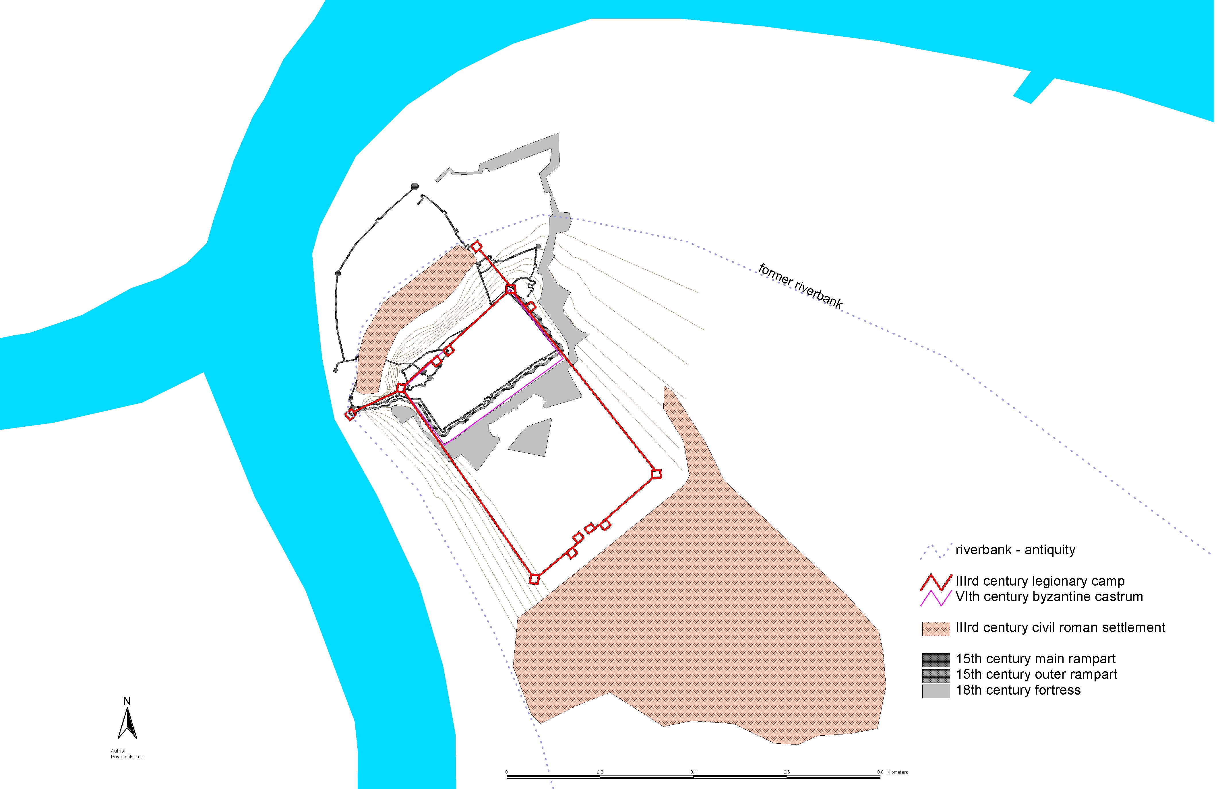
Singidunum ( sr, Сингидунум/''Singidunum'') was an ancient city which later evolved into modern Belgrade, the capital of Serbia. The name is of Celts, Celtic origin, going back to the time when Celtic tribe Scordisci settled the area in the 3rd century BC, following the Gallic invasion of the Balkans. Later on, the Roman Republic conquered the area in 75 BC and incorporated it into the province of Moesia. It was an important fort of the Danubian Limes and Roman Legio IV Flavia Felix was garrisoned there since 86 AD. Singidunum was the birthplace of the Roman Emperor Jovian (Emperor), Jovian. It was sacked by Huns in 441, and by Pannonian Avars, Avars and South Slavs, Slavs in 584. At the beginning of the 7th century, the Singidunum fort was finally destroyed. A large part of Belgrade's downtown belongs to the "Archaeological Site of Singidunum", which was declared a protected zone on 30 June 1964. Celtic period Origin The Scythian and Thracian-Cimmerian tribes tra ... [...More Info...] [...Related Items...] OR: [Wikipedia] [Google] [Baidu] |
Kalemegdan
The Kalemegdan Park ( sr, / ), or simply Kalemegdan ( sr-Cyrl, Калемегдан) is the largest park and the most important historical monument in Belgrade. It is located on a cliff, at the junction of the River Sava and the Danube. Kalemegdan Park, split in two as the Great and Little Parks, was developed in the area that once was the town field within the Belgrade Fortress. Today residents often erroneously refer to the entire fortress as the Kalemegdan Fortress or just Kalemegdan, even though the park occupies the smaller part, especially of the historical fortress, and it is some two millennia younger. The fortress, including the Kalemegdan, represents a cultural monument of exceptional importance (from 1979), the area where various sport, cultural and arts events take place, for all generations of Belgraders and numerous visitors of the city. History Pre-park history The name is formed from the two Turkish words: ''kale'' (meaning "fortress") and meydan' (mea ... [...More Info...] [...Related Items...] OR: [Wikipedia] [Google] [Baidu] |
Jevremovac
The Jevremovac Botanical Garden ( sr-cyr, Ботаничка башта Јевремовац, Botanička bašta Jevremovac) is the botanical garden of the University of Belgrade and also a surrounding urban neighborhood of Belgrade, Serbia. The garden is located in Belgrade's municipality of Stari Grad and is an administered by the University of Belgrade's Biology School. It has been declared a natural monument in 1995 and a cultural monument in 2007. Location Jevremovac is located in the westernmost part of the Palilula neighborhood, but after the changes of the municipal administrative borders in 1952, 1955 and 1957, it didn't become part of the municipality of Palilula but of Stari Grad. It is bounded by the ''Boulevard of despot Stefan'' and the streets of '' Takovska'', ''Dalmatinska'', ''Palmotićeva'' and ''Vojvode Dobrnjca''. Botanical garden History The botanical garden was founded in 1874 by the decree of the Ministry of Education of the Kingdom of Serbia, ... [...More Info...] [...Related Items...] OR: [Wikipedia] [Google] [Baidu] |
List Of Belgrade Neighbourhoods And Suburbs
Belgrade, the capital city of Serbia, is divided into seventeen municipalities, of which ten are urban and seven suburban. In this list, each neighbourhood or suburb is categorised by the municipality in which it is situated. Six of these ten urban municipalities are completely within the bounds of Belgrade City Proper, while the remaining four have both urban and suburban parts. The seven suburban municipalities, on the other hand, are completely located within suburban bounds. Municipalities of the City of Belgrade are officially divided into local communities ( Serbian: месна заједница / ''mesna zajednica''). These are arbitrary administrative units which on occasion correspond to the neighbourhoods and suburbs located in a municipality, though usually they don't. Their boundaries often change as the communities merge with each other, split from one another, or change names, so the historical and traditional names of the neighbourhoods survive. In the majority ... [...More Info...] [...Related Items...] OR: [Wikipedia] [Google] [Baidu] |
List Of Belgrade Neighborhoods
Belgrade, the capital city of Serbia, is divided into seventeen municipalities, of which ten are urban and seven suburban. In this list, each neighbourhood or suburb is categorised by the municipality in which it is situated. Six of these ten urban municipalities are completely within the bounds of Belgrade City Proper, while the remaining four have both urban and suburban parts. The seven suburban municipalities, on the other hand, are completely located within suburban bounds. Municipalities of the City of Belgrade are officially divided into local communities ( Serbian: месна заједница / ''mesna zajednica''). These are arbitrary administrative units which on occasion correspond to the neighbourhoods and suburbs located in a municipality, though usually they don't. Their boundaries often change as the communities merge with each other, split from one another, or change names, so the historical and traditional names of the neighbourhoods survive. In the majorit ... [...More Info...] [...Related Items...] OR: [Wikipedia] [Google] [Baidu] |
Dušan Of Serbia
Dušan ( sr-Cyrl, Душан) is a Slavic names, Slavic given name primarily used in countries of Yugoslavia; and among Slovaks and Czechs. The name is derived from the Slavic noun ''duša'' "soul". Occurrence In Serbia, it was the 29th most popular name for males, as of 2010. (in Slovenian). Statistical Office of the Republic of Slovenia. People *Stefan Uroš IV Dušan, Emperor of the Serbian Empire *Dušan Bajević, Serbian footballer and football manager *Dušan Bařica, Czech ice hockey player *Dušan Basta, Serbian footballer *Dušan Bogdanović, Serbian-born American composer and classical guitarist *Dusan Djuric, Swedish international footballer of Serbian descent *Dušan Domović Bulut, Se ...[...More Info...] [...Related Items...] OR: [Wikipedia] [Google] [Baidu] |


.png)

.jpg)


