|
Dondra Head Lighthouse
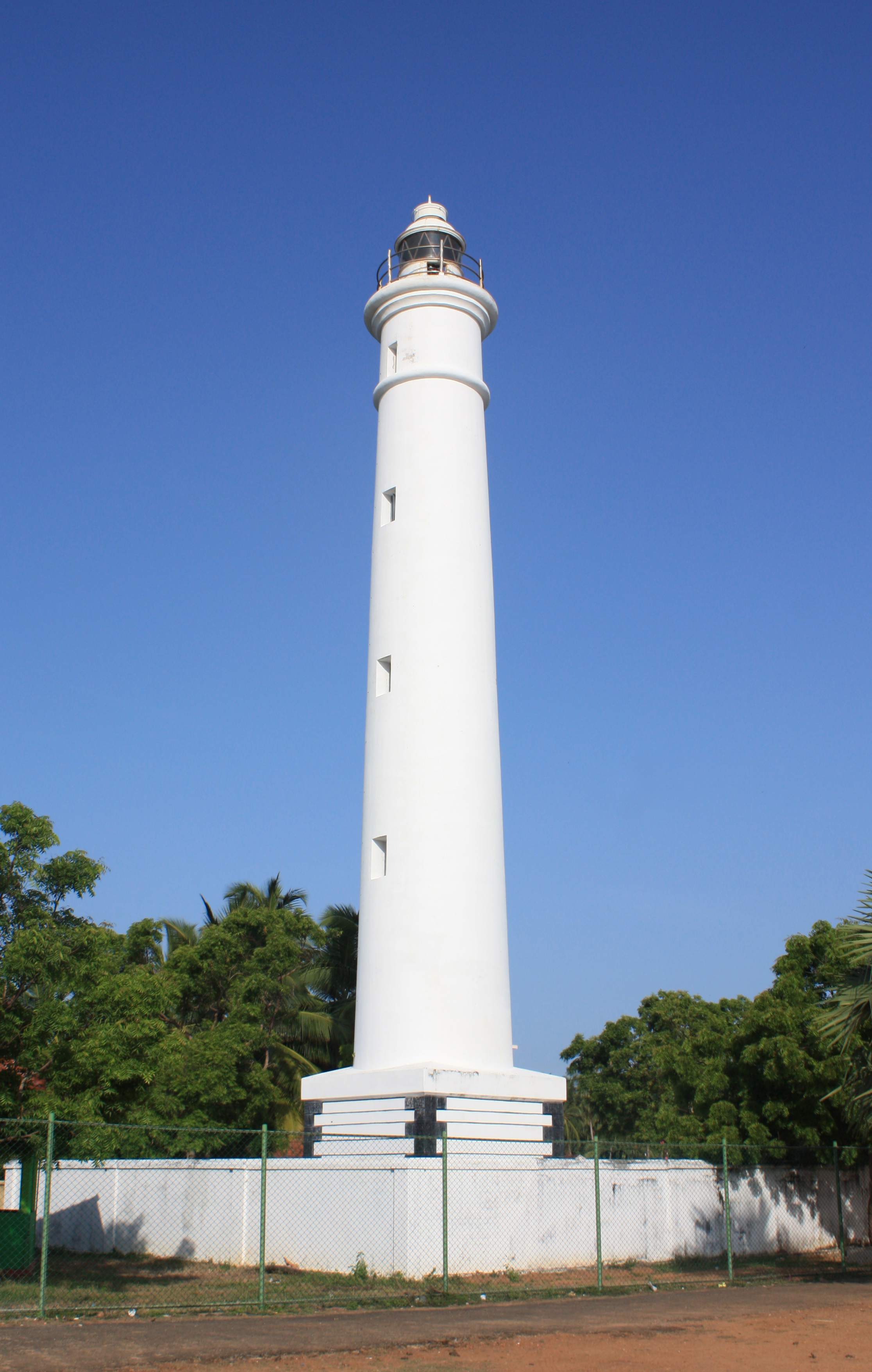
Dondra Head Lighthouse is a lighthouse located on Dondra Head, Dondra, the southernmost point in Sri Lanka and is Sri Lanka's tallest lighthouse, and also one of the tallest in South East Asia. Dondra Head lighthouse is operated and maintained by the Sri Lanka Ports Authority. The lighthouse is near the village of Dondra, and is approximately southeast of Matara. The name Dondra is a synonym for "Devi-Nuwara" in the local Sinhala language, "Devi" meaning "Gods" and "Nuwara" meaning "City". Dondra is therefore derived to mean "City of the Gods". History Dondra Head Lighthouse was designed by Sir James Nicholas Douglass, with construction, by William Douglass of the Imperial Lighthouse Service, commencing in November 1887. All the building materials including the bricks and steel were imported from England. The granite rock was supplied from quarries at Dalbeattie in Scotland and Penryn in Cornwall. The lighthouse was completed and commissioned in March 1890. The combine ... [...More Info...] [...Related Items...] OR: [Wikipedia] [Google] [Baidu] |
Dondra
Dondra (, ) is a settlement on the extreme southernmost tip of Sri Lanka, in the Indian Ocean near Matara, Southern Province, Sri Lanka. The Dondra Head Lighthouse, ruins of several Hindu shrines of Tenavaram and a Vihara (Buddhist temple) are located in the vicinity. Etymology King Nissankamalla's (1187-1196 A.D.) Dambulla Vihara rock inscription is considered the oldest document that mentions the name Devi-nuwara which means the "City of Gods". The Pali form of the name, Deva-nagara appears for the first time in the Mahavamsa with reference to the reign of King Vijayabahu I (1058-1114 A.D.).The Buddhist Vishnu: Religious Transformation, Politics, and Culture By John C. Holt, pp. 5, 67-87, 97-100, 113, 257, 343, 413 (Columbia University Press) The name Dondra is the ... [...More Info...] [...Related Items...] OR: [Wikipedia] [Google] [Baidu] |
Penryn, Cornwall
Penryn (; kw, Pennrynn, meaning 'promontory') is a civil parish and town in west Cornwall, England, United Kingdom. It is on the Penryn River about northwest of Falmouth. The population was 7,166 in the 2001 census and had been reduced to 6,812 in the 2011 census, a drop of more than 300 people across the ten-year time gap. There are two electoral wards covering Penryn: 'Penryn East and Mylor' and 'Penryn West'. The total population of both wards in the 2011 census was 9,790. Though now the town is overshadowed by the larger nearby town of Falmouth, Penryn was once an important harbour in its own right, lading granite and tin to be shipped to other parts of the country and world during the medieval period. History Early history The ancient town first appears in the Domesday Book under the name of "Trelivel", and was since founded and named Penryn in 1216 by the Bishop of Exeter. The borough was enfranchised and its Charter of Incorporation was made in 1236. The content ... [...More Info...] [...Related Items...] OR: [Wikipedia] [Google] [Baidu] |
Lighthouses In Sri Lanka
This is a list of lighthouses in Sri Lanka. There are 14 active lighthouses in Sri Lanka. Most of the lighthouses in Sri Lanka are operated and maintained by the Sri Lanka Ports Authority (SLPA). However several are operated by the Sri Lanka Navy, while some are inactive. Retrieved 14 November 2016 History Most of the lighthouses in Sri Lanka were built during the rule of the country (then known as Ceylon). These were operated and maintained by the Imperial Lighthouse Serv ...[...More Info...] [...Related Items...] OR: [Wikipedia] [Google] [Baidu] |
Lighthouses Completed In 1889
A lighthouse is a tower, building, or other type of physical structure designed to emit light from a system of lamps and lenses and to serve as a beacon for navigational aid, for maritime pilots at sea or on inland waterways. Lighthouses mark dangerous coastlines, hazardous shoals, reefs, rocks, and safe entries to harbors; they also assist in aerial navigation. Once widely used, the number of operational lighthouses has declined due to the expense of maintenance and has become uneconomical since the advent of much cheaper, more sophisticated and effective electronic navigational systems. History Ancient lighthouses Before the development of clearly defined ports, mariners were guided by fires built on hilltops. Since elevating the fire would improve the visibility, placing the fire on a platform became a practice that led to the development of the lighthouse. In antiquity, the lighthouse functioned more as an entrance marker to ports than as a warning signal for reefs a ... [...More Info...] [...Related Items...] OR: [Wikipedia] [Google] [Baidu] |
List Of Lighthouses In Sri Lanka
This is a list of lighthouses in Sri Lanka. There are 14 active lighthouses in Sri Lanka. Most of the lighthouses in Sri Lanka are operated and maintained by the Sri Lanka Ports Authority (SLPA). However several are operated by the Sri Lanka Navy, while some are inactive. Retrieved 14 November 2016 History Most of the lighthouses in Sri Lanka were built during the rule of the country (then known as Ceylon). These were operated and maintained by the |
Differential Global Positioning System
Differential Global Positioning Systems (DGPSs) supplement and enhance the positional data available from global navigation satellite systems (GNSSs). A DGPS for GPS can increase accuracy by about a thousandfold, from approximately to . DGPSs consist of networks of fixed position, ground-based reference stations. Each reference station calculates the difference between its highly accurate known position and its less accurate satellite-derived position. The stations broadcast this data locally—typically using ground-based transmitters of shorter range. Non-fixed (mobile) receivers use it to correct their position by the same amount, thereby improving their accuracy. The United States Coast Guard (USCG) and the Canadian Coast Guard (CCG) each run DGPSs in the United States and Canada on longwave radio frequencies between and near major waterways and harbors. The USCG's DGPS was named NDGPS (Nationwide DGPS) and was jointly administered by the Coast Guard and the U.S. Departmen ... [...More Info...] [...Related Items...] OR: [Wikipedia] [Google] [Baidu] |
Chance Brothers
Chance Brothers and Company was a glassworks originally based in Spon Lane, Smethwick, West Midlands (formerly in Staffordshire), in England. It was a leading glass manufacturer and a pioneer of British glassmaking technology. The Chance family originated in Bromsgrove in Worcestershire as farmers and craftsmen, before setting up business in Smethwick in 1822. Situated between Birmingham and the Black Country in the agglomeration of the Midlands industrial heartland, they took advantage of the skilled workers, canals and many advances that were taking place in the industrial West Midlands at the time. Throughout its almost two centuries of history many changes affected the company which, now privatised, continues to function as Chance Glass Limited, a specialised industrial glass manufacturer in Malvern, Worcestershire at one of its small subsidiary factories. The social and economic impact of the company on the region is the subject of a project sponsored by the Heritage Lo ... [...More Info...] [...Related Items...] OR: [Wikipedia] [Google] [Baidu] |
Hyperradiant Fresnel Lens
Hyper-radial or hyperradiant Fresnel lenses are Fresnel lenses used in lighthouses. They are larger than "first-order" lenses, having a focal length (radius) of 1330 mm (52.36 inches). The idea was mentioned by Thomas Stevenson in 1869 and first proposed by John Richardson Wigham in 1872, and again proposed by Thomas Stevenson in 1885 (infringing Wigham's patent). The hyper-radial lens was made in 1885 by the F. Barbier Company in Paris as a test lens for the lighthouse illumination trials then going on at the South Foreland Lighthouse in the United Kingdom (UK). Chance Brothers Glass Company made their first hyper-radial lens in 1887 in the UK. These lenses were originally named biform, and later triform and quadriform lenses, by Wigham. Thomas Stevenson used the term hyperradiant lens, and later they were renamed the hyper-radial lens by James Kenward of the Chance Brothers Glass Company. The hyper-radial Fresnel lenses were the largest ever put into use and were installe ... [...More Info...] [...Related Items...] OR: [Wikipedia] [Google] [Baidu] |
Barberyn Lighthouse
Barberyn Lighthouse (also known as Beruwala Lighthouse) is a lighthouse located on Barberyn Island. Barberyn Island a island situated offshore from the town of Beruwala on the south-west coast of Sri Lanka, south of Colombo.The lighthouse is a high round white conical granite tower. The lighthouse was completed in November 1889, and operated by the Imperial Lighthouse Service. In 1969 it was upgraded with the replacement of the old dioptric apparatus (produced by Chance Brothers) and with a pedestal rotating beacon (Pharos Marine PRB-21 sealed beam optic and drive pedestal). It was further modernised in 2000, with the introduction of a Differential Global Positioning System (DGPS) and is computer linked to the other major lighthouses around the country. The Barberyn Lighthouse is one of the four international lighthouses in Sri Lanka. See also * List of lighthouses in Sri Lanka This is a list of lighthouses in Sri Lanka. There are 14 active lighthouses in Sri Lanka. Most o ... [...More Info...] [...Related Items...] OR: [Wikipedia] [Google] [Baidu] |
Dalbeattie
Dalbeattie (, sco, Dawbeattie, gd, Dail Bheithe meaning 'haugh of the birch' or ''Dail'' ''bhàite'' 'drowned (''i.e.'' liable to flood) haugh') is a town in the historical county of Kirkcudbrightshire in Dumfries and Galloway, Scotland. Dalbeattie is in a wooded valley on the Urr Water east of Castle Douglas and south west of Dumfries. The town is famed for its granite industry and for being the home town of William McMaster Murdoch, the First Officer of the RMS ''Titanic''. Etymology Dalbeattie is a Gaelic name, recorded in 1469 as ''Dalbaty''. The first element of the name is Gaelic ''dail'' 'water-meadow, haugh'. There are two possible interpretations for the second element. The most common is Gaelic ''beithich'', genitive singular of ''beitheach'' 'abounding in or relating to birch trees', derived from ''beith'' 'birch'. Dalbeattie would thus mean 'haugh of the birch'. The second interpretation takes -''beattie'' to be ''bhàite'' (from ''bàite'') 'drowned', meaning ' ... [...More Info...] [...Related Items...] OR: [Wikipedia] [Google] [Baidu] |
Southern Province, Sri Lanka
The Southern Province ( si, දකුණු පළාත ''Dakuṇu Paḷāta'', ta, தென் மாகாணம் ''Theṉ Mākāṇam'') of Sri Lanka is one of the nine provinces of Sri Lanka, the first level administrative division of the country. The provinces have existed since the 19th century but did not have any legal status until 1987 when the 13th Amendment to the Constitution of Sri Lanka established provincial councils. It is the 7th largest province by area and is home to 2.5 million people, the 3rd most populated province. The province is bordered by Sabaragamuwa Province and Uva Province to the North, Eastern Province to the Northeast, Western Province to the Northwest and the Indian Ocean to the South, West and East. The Province's capital is Galle. The Southern Province is a geographic area consisting of the districts of Galle, Matara and Hambantota. Subsistence farming and fishing is the main source of income for the vast majority of the people of this ... [...More Info...] [...Related Items...] OR: [Wikipedia] [Google] [Baidu] |
Imperial Lighthouse Service
The Imperial Lighthouse Service was the official general lighthouse authority for the British Empire. This was with the exception of: England and Wales, the Channel Islands, Gibraltar and the Falkland Islands (all dealt with by Trinity House); Scotland and the Isle of Man (dealt with by the Northern Lighthouse Board); and Ireland (dealt with by the Commissioners of Irish Lights). The Imperial Lighthouse Service came under the control of the Board of Trade and was responsible for the provision and maintenance of navigational aids such as lighthouses, lightvessels, and buoys in all colonies of the British Empire The British Empire was composed of the dominions, colonies, protectorates, mandates, and other territories ruled or administered by the United Kingdom and its predecessor states. It began with the overseas possessions and trading posts e .... With the end of the British Empire most of these lighthouses were taken over by the newly independent countries and the ... [...More Info...] [...Related Items...] OR: [Wikipedia] [Google] [Baidu] |


